5TH EUROPEAN MEETING ON GEOLOGICAL 3D MODELLING - EUROGEOSURVEYS
←
→
Page content transcription
If your browser does not render page correctly, please read the page content below
5th European Meeting on Geological 3D Modelling
                               “The role of 3D geology in spatial planning”

                                          First call & Save the date

To continue the tradition of European workshops on 3D geological modelling that took place in the past
years, the Swiss Geological Survey cordially invites you to join the community between

                                         May 21st – 24th 2019
                                         Berne - Switzerland

                                                           The mistakes we make in the subsurface today
                                                           can hardly be corrected in the future. First-come,
                                                           first-serve mentalities have been dominating the
                                                           usage of the underground in many countries for
                                                           a long time now. It is widely accepted that
                                                           increased usage of the underground will lead to
                                                           conflicts without proper planning. Combined 3D
                                                           representations of the surface and subsurface
                                                           will be key to providing sustainability of one of
                                                           our most important resources. This is especially
        © swisstopo 2012
                                                           true in the heavily utilized metropolitan areas
                                                           throughout Europe.
                                                           However, in most cases, spatial planning has
                                                           been dealing with issues above the surface up to
now, only. Given the ideas mentioned above, real spatial planning should also comprise the subsurface and,
therefore, must urgently incorporate 3D geological data, its abilities and capabilities into its concepts. On
the other hand, geological 3D modelling performed a rapid rise from specialist’s toys to highly relevant
fundamentals in today’s societies during the last decades.

The emerging role of 3D geological modelling with respect to spatial planning in the underground is the
inspiration for this meeting. Besides the benefits of 3D geological modelling for society, the meeting shall
also address case studies, advances in research and software development, trends, data dissemination,
data infrastructure, application in resource management and demos related to the main topic.

The conference focus on European GSOs, their needs, practical solutions and open knowledge exchange.
However, exchange with academia and industry is much appreciated. The meeting relies on your
contribution! We invite you and/or your delegates to contribute to the conference with either a talk in one
of the sessions described below, or a poster or demonstration. Thematic suggestions for the breakout
sessions during the conference are also welcome.

PRE-REGISTRATION
Please pre-register here (without obligation): https://de.surveymonkey.com/r/LX5FX29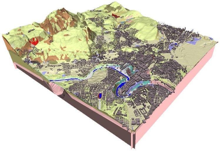
GOOD TO KNOW
Venue                   “Kursaal Congress Center + Hotel”
Costs                   The meeting is free of charge, as are the excursions, the Ice Breaker event and,
                        presumably, the conference dinner.
Program                 The program is divided into four conference blocks (slots for 30 talks of 15 min.,
                        poster sessions and two break-out sessions), accompanied by two excursions and
                        two social events. Please refer to the preliminary program below.
Participants            The number of attendees is limited to 100 participants, which allows for three or at
                        the most four participants per organization.
Travel                  Closest international airports are Zurich, Basel-Mulhouse (F) and Geneva, from
                        where you can reach Bern within 90 minutes and 120 minutes by train, respectively.
                        Train tickets are available at the airport train stations. Train tickets cannot be
                        purchased on the trains.
Accommodation           Please refer to your preferred booking website.
Public Transport        All meeting locations in the city of Berne are within walking distance of each other.
                        Bern also features an excellent public transport network – check with your hotel for
                        a free public transportation card.
Sports                  The 3D Modelers Running Group (jointly led by Swiss Geological Survey and British
                        Geological Survey) will organize daily pre-conference runs.

THE SESSIONS

3D geological modelling and the benefit for society
Recently, 3D geological modelling reached the Yellow Press in Switzerland, which underpins the importance
of geological data for everyday life. Geological data is one of the foundations for the assurance of supply,
civil protection, development of infrastructure or the supply of goods, where it plays a substantial role.
Other topics such as waste disposal, georesource management, public health and hygiene, culture, civil
engineering, etc. also heavily rely on geological data and information.
This session covers best practices within these topics, but also deals with the economic benefit of 3D
geological modelling, data access, spatial planning, political and societal impacts. It also hosts the practical
application of 3D geological modelling, modelling methodologies, workflows, collaborative modelling,
Public Private Partnerships, data integration and data manipulation etc.

The 5th dimension: Model certainty and reliability
Certainty is the new uncertainty! How can certainty of a model be computed, visualized, delivered and
conveyed to the client? Societal awareness of the underground (incl. 3D geological data) is steadily rising.
Geologists play an important role as knowledge facilitators between their playground and the citizen’s
backyard. What are the newest and most promising approaches to act responsibly?
This session covers all the aspects, results and findings related to certainty modelling, predictive modelling
approaches, workflows, instruments, tools etc. Despite these topics having been under debate for a long
time, their recent developments are as important as never before.

                                                                                                              2/5
Advances in research and software development
Research and industry push continuous advancements in 3D modelling. Recent improvements with respect
to methodologies, processes, large scale modelling approaches, as well as practical software development
continuously make their way into to practical application of 3D geological modelling.
This session allows insights into new results of fundamental or applied research, while covering
methodologies, process modelling, field data acquisition, implicit and explicit modelling, back coupling
between 2D and 3D data, etc.
Trends and innovation
Increasing demands, requirements that increase in complexity and technical progress constantly require a
rethinking of our processes, enhancing our knowledge and upskilling our capabilities. BIM is poised to
become one of the main drivers for innovation in the near future, including applied geology. Buzzwords
such as Machine Learning, Neural Networks, Big Data etc. have been used in earth sciences for many years,
their broad range of possible practical applications is, however, still being discovered.
What stands behind these terms, what are the most recent developments, how is geology affected and
how can 3D geology benefit from their application? These are only few of the questions this session will
cover.
Data dissemination, data infrastructure and data management
The emerging importance of 3D geological models parallels the need for innovative approaches and
powerful solutions for data dissemination. In our role as earth science professionals in a public service or as
a consultant, one of our most important tasks is to communicate our work and its results to clients or the
general public. Convincing communication depends on reliable data and therefore standards,
infrastructure, visualization and access possibilities. What are possible business models for effective
communication? Which infrastructure do we really need? What is best practice in data management? Are
there any further prerequisites for these topics? What can we learn from other disciplines?
Even though the conference will be taking place in over half a years’ time, we are already looking forward
to welcoming you to Bern. Please do not hesitate to contact us should you have any questions.
Sincerely, on behalf of the Swiss Geological Survey
Roland Baumberger Robin Allenbach
roland.baumberger[at]swisstopo.ch robin.allenbach[at]swisstopo.ch
+41 58 469 05 75 +41 58 463 03 63
3/5PRELIMINARY PROGRAM
TUE 21/05/2019 WED 22/05/2019 THU 23/05/2019 FRI 24/05/2019
PRE-CONFERENCE RUN PRE-CONFERENCE RUN PRE-CONFERENCE RUN PRE-CONFERENCE RUN
Early morning guided by Roland and Holger guided by Roland and Holger guided by Roland and Holger guided by Roland and Holger
45 – 60 minutes 45 – 60 minutes 45 – 60 minutes 45 – 60 minutes
PRE-CONFERENCE PRE-CONFERENCE CONFERENCE #2 CONFERENCE #4
9:00 – 12:00 9:00 – 12:30 9:00 – 12:30
Morning Mont Terri Historical-geological city tour Talks Talks
Underground Rock Laboratory Guided by the University of Bern Posters Posters
10:00/11:00 – 19:00h free of charge Break-out session 1
https://www.mont-
terri.ch/en/homepage.html CONFERENCE #1 CONFERENCE #3
guided visit 13:30 – 17:30 13:30 – 17:30
Afternoon incl. transport and lunch Talks Talks
free of charge Posters Posters
Break-out session 2
SPONTANEOUS PROGRAM ICE BREAKER CONFERENCE DINNER
19:00 – 22:00 19:00 – 23:00
Museum of Natural History Restaurant “Zunft zu Webern”
Evening
https://www.nmbe.ch/en http://www.restwebern.ch
free of charge presumably free of charge
Legend: Pre-conference program | Conference program | Social program | Sports
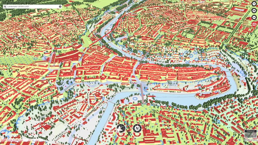
4/5MAP – THE CITY CENTRE OF BERN AND THE MEETING LOCATIONS
2D map: https://s.geo.admin.ch/7d84aa4b91
3D view: https://s.geo.admin.ch/7d84b056f6
Conference venue
Train station
Conference dinner
Bears!
Ice Breaker
5/5You can also read