Hurricane Survival Guide for New Jersey - ready.nj.gov facebook.com/READYNEWJERSEY twitter.com/@READYNJ instagram.com/ReadyNJ - New Jersey ...
←
→
Page content transcription
If your browser does not render page correctly, please read the page content below
Hurricane Survival Guide
                 for New Jersey

                             ready.nj.gov
facebook.com/READYNEWJERSEY • twitter.com/@READYNJ • instagram.com/ReadyNJ
Time to Get Ready...
             Hazardous weather impacts New Jersey residents on a regular basis. Many
             of us have experienced the long-term power outages, flooding, evacuations,
             property destruction, debris and other impacts to our daily lives that can
             result from the onset of nature’s fury. We can’t stop the onset of a natural
hazard; but there are steps you can take to increase your safety and comfort when ad-
verse conditions occur.
We encourage you to read through this “Hurricane Survival Guide for New Jersey,” and
take the actions necessary to secure your family and home. The preparations you make
for hurricanes will also help you survive all types of natural disasters.
The first step is to stay informed, via traditional or social media. The second step is to
discuss hurricanes and other natural hazards with family members and determine ways
to stay close and connected regarding your evacuation plans and locations. Consider
those in your family or community who might need extra assistance, due to age or dis-
ability, regarding emergency plans. Don’t forget your pets! The third step involves gath-
ering emergency supplies; many of these items can be found around your home.
Get ready now, be an example for others, share this information with those who need it.
And thank you for being part of a more prepared New Jersey.
                                THE NEW JERSEY OFFICE OF EMERGENCY MANAGEMENT

 Tropical Storm Watch                         Hurricane Watch
 A tropical storm watch is issued             A hurricane watch is issued for
 when tropical storm conditions,              a specified area when hurricane
 including winds from 39 to 73                conditions, including sustained winds
 mph, pose a possible threat to a             of 74 mph or greater, are possible
 specified area within 48 hours.              within 48 hours.

 Tropical Storm Warning                       Hurricane Warning
 A tropical storm warning is issued           A hurricane warning is issued for
 when tropical storm conditions are           a specified area when hurricane
 expected to affect a specified area           conditions are expected within 36
 within 36 hours.                             hours. In coastal or near-coastal
                                              areas, a hurricane warning can remain
                                              in effect when dangerously high water
                                              and exceptionally high waves continue
                                              even though the winds may have
                                              subsided below hurricane intensity.

      The Atlantic hurricane season lasts from June 1 to
     November 30. New Jersey’s tropical storm activity is
         typically between August and late October.
                                                             NJ Hurricane Survival Guide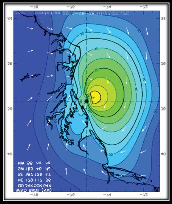
STEP 1:

Stay Informed
On The Web:
Use credible websites to get information about natural hazards and emergency
preparedness. The NJOEM works closely with the National Weather Service and the
National Hurricane Center regarding storm predictions and forecasts.
Nat. Weather Service Philadelphia/Mt. Holly - www.weather.gov/phi
Nat. Weather Service NYC (NE NJ Counties) - www.weather.gov/nyc
National Hurricane Center - http://www.nhc.noaa.gov/
N.J. Office of Emergency Management - ready.nj.gov
                                                                             Scan for
                                                                             NJOEM on
NJ 2-1-1 - NJ Residents can dial 2-1-1, toll-free, for preparedness and
                                                                             Facebook
disaster-related info 24/7 or www.nj211.org.
Federal Emergency Management Agency – www.ready.gov

Social Media:
Social media and other advanced communications technologies are used
by the EMS and by emergency managers statewide. Find out if your
community has a “reverse 9-1-1” system or if you can opt-in for email        Scan for
                                                                             NJOEM on
updates from municipal officials.

           {
                                                                             Twitter
NJOEM            Facebook: http://www.facebook.com/READYNEWJERSEY
 on:             Twitter:      www.twitter.com/READYNJ
                 Instagram: www.Instagram.com/READYNJ

           {
NJ State         Facebook: www.facebook.com/NewJerseyStatePolice
 Police          Twitter:      www.twitter.com/NJSP
  on:            Instagram: www.Instagram.com/NewJerseyStatePolice           Scan for
                                                                             NJOEM on
                                                                             Instagram
                            Nextdoor
                            Nextdoor is the world’s largest social
                            network for the neighborhood. As a member
                            of Nextdoor that lives in New Jersey, you will
                            automatically receive our safety notifications
                            and updates during times of emergency.
                            Go to: www.nextdoor.com                          Scan for
                                                                             NJOEM on
                                                                             Nextdoor
ready.nj.gov                                                                         1
Alerts - Mobile/Text (SMS) & Email:
Nixle: Subscribe to the NJ State Police on Nixle Connect:
http://local.nixle.com/new-jersey-state-police
Nixle is an application that allows verified government agencies to communicate with
the public via text/SMS, email, and internet posts. This service is provided at no cost
to the department, taxpayers, or residents. Unlike other social media applications,
Nixle does not contain any third-party advertisements. New Jersey residents can
register to receive messages by sending a text message with their zip code to
888777 (data rates may apply depending on your plan). Online registration is also
available at: www.nixle.com.
CMAS (Community Mobile Alert System) is a nationwide system now being
employed by the National Weather Service to transmit weather Warnings (but not
Watches) to your cell phone. A warning means the hazard is imminent; a watch
means conditions are favorable for the hazard to occur. Your cell phone must be WEA
(Wireless Emergency Alert) enabled to receive these messages, so it depends on the
make/model of the phone. There is an opt-out option, but we recommend that
you do not opt-out of receiving these NWS messages. Read about WEA alerts
here: https://www.weather.gov/wrn/wea
NOAA Weather Radio:
NOAA Weather Radio is a nationwide network of radio stations broadcasting
continuous weather information directly from the nearest National Weather Service
Office. NOAA Weather Radio broadcasts official Weather Service warnings, watches,
forecasts and other hazard information 24 hours a day, 7 days a week. NOAA
Weather Radios are typically inexpensive, easily available in stores and can
often be programmed for your specific area.
National Weather Service Phila./Mt. Holly
http://www.nws.noaa.gov/nwr/Maps/PHP/NJ.php
National Weather Service NYC (for NE NJ Counties)
https://www.weather.gov/okx/wxradio
Traditional Media:
Continue to monitor traditional media sources — TV, newspapers and radio — to
stay informed of breaking news and continued coverage of emergency events.
Find out if your community has a “reverse 9-1-1” system or if you can opt-in for
email updates from municipal officials.
This NJOEM website contains a link to New Jersey’s 21 County Offices of
Emergency Management with county websites, social media tools and county
alert and warning systems listed as well. Sign up, opt-in or connect to receive
important local alerts. http://ready.nj.gov/about-us/county-coordinators.shtml
2 NJ Hurricane Survival Guide
STEP 2:
Make a Plan
Get together with your family and create a communications plan ahead of time.
This will help you and your family to connect as quickly and easily as possible
after the storm.
Keep a written record of all important phone numbers.
Designate an individual outside of the state to serve as a family point of contact.
(After a disaster it is often easier to call out-of-state than within the affected
area.)
Make sure that all family members know who this person is and how to contact
them.
After a disaster or evacuation, all family members should make contact with the
designated individual. Try choosing a certain time for everyone to check in.
Our Family Communications Plan
Setting up a Family Communications Plan ahead of time will make sure you and
your family can connect as easily and quickly as possible.
ready.nj.gov 3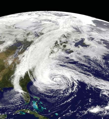
STEP 3:
Build a Hurricane Kit
Use these suggestions as a guide for gathering your hurricane
supplies. Remember these critical points:
• Stock a 2 week supply of these emergency necessities.
• Store clean-up and repair supplies in a safe place.
• Make your hurricane kit portable in case you need to evacuate.
• Don’t forget special supplies for babies, the elderly, and those with access or
functional needs.
• Review homeowner’s or renter’s insurance plan as it relates to natural disasters.
the basics.
Alarm clock (battery operated) Eating & cooking utensils
Battery or crank-operated radio/TV Emergency cooking facilities (grill/
NOAA All-Hazards radio camp stove)
}
Gas for the grill CAUTION: Store
Flashlights (one per person) properly in approved
Batteries for radio/flashlights to Cans, gas & oil containers.
last several days Butane lighter
Fire extinguisher Work boots/shoes
First aid kit & manual Change of clothes
Cash, credit cards Sleeping bags, sheets & towels
Driver’s license Blankets & pillows
Cellular phones & chargers Bleach without scents/additives (in
Important phone numbers a secure, well-marked container)
Prescriptions, including eyeglasses Soap, shampoo & toiletries
Water, 1 gallon per person per day Sponges/paper towels
Water purification tablets Toilet paper & towelettes
Coolers for food & water Feminine hygiene products
Canned & dried food Baby food, diapers & formula
Non-electric can opener Toys (to occupy children)
Pots & pans Pet food
4 NJ Hurricane Survival Guide
important papers.
Social security cards Stocks & bonds
Birth certificates Inventory of household goods
Marriage & death records Computer file backups
Wills Pictures (both personal & of
Insurance policies belongings)
Deeds & mortgages Savings & checking books
cleanup & repair supplies.
Axes, hammers & hatchets Extension cords
Bars, wrecking & crow Generators
Brooms Heavy plastic tarps
Camera to record damage Inflatable raft
Chain, steel Ladders
Chain saw & fuels Lanterns & fuel
Caulk & caulking gun Lumber
Cleaning supplies Mosquito repellent
Duct & masking tape Plastic trash bags
*
Drills & bits Nails, screw, bolts
Store your kit in a convenient place known to all family members.
Keep a smaller version of the supply kit in the trunk of your car.
Change your stored water supply every six months so it stays
fresh. Replace batteries, update clothes.
ready.nj.gov 5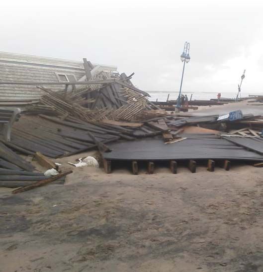
s T o R e m e m ber
                 p
    Important Ti
                                                                 !
                             to  ld  to    evacuate, GO                                                         ou
    • If you        a re
                                                                   o  r  w  it h   y o  u  at ALL times. Y
                                                         oes o n
        M  a k e  su  re    y ou have your sh
    •                                                      .
                                   vacuate quickly
         may need to e                                                        so     a re   the ATMs and
                                                       power    is  o  u  t,
         H  av e  ca  sh     o n hand. If the
     •
                                   chines.
         credit card ma                                                      h  e   g a s  pumps will not
                                                      f the sto   rm    .  T                                       s.
            a s  u p   y  o u r cars ahead o                         d  a m   a  g e d   to   open afterward
     •    G                                                 e to o
                                     ower or may b
          work without p                                                     o  rs   w  h  o  have access o
                                                                                                                 r
                                                          and n    e ig h  b
           B e  su  re   to   ch   eck on friends
      •
                                    ds.
           functional nee                                                      a  n d   a n d   keep them in a
                                                         ications     o n   h
           B e  su   re   to   h ave extra med
       •
                                     t container.
            water resistan                                                       ce    p a p ers together N
                                                                                                                 OW.
                                                         s and in    su   ra  n                                   d
            G e t  a ll  o f  y o ur vital record                   n  ta  in  e  r.  If  y o u can, scan an
       •                                                     nt co                                                bers
                                     a water resista                                         important num
            Keep them in                                     u ha  v  e   a  co    p y  o f
                                      yourself so yo
             email them to
                                      tc.
             and policies, e                                                       to   u se   them if the po
                                                                                                                   wer
                                                          s and    tr y    n o  t                                 t
             C h  a rg  e  u  p  y our cell phone                 e r   th  a n    a  ce  ll call, so use tex
         •                                                    ow
                                        ng uses less p
              goes out. Texti                    ss ib le to  save power.
                                       e n   p o
              messaging wh                                                         W   h e th er you are the
                                                             plan   s   n o w   .                                ued
              D  iscu   ss    b u siness continuity                   y  o u  r  g  a m   e  plan for contin
          •                                                      ss
                                         to a boss, discu
              boss or report
                                         tions.
               business opera                                                        a ra  g e s, crawlspaces,
                                                           side h   o m    e s,   g                             doors
                                    a generator in                                          ns or opening
           • NEVER use                                           w  h e  n  u  si  n g   fa
                                                                                                                oxide
                                         ar areas, even                                    of carbon mon
               sheds, or simil                                       a d  ly   le  v e ls
                           in d  o w s  fo  r  ventilation. D      e
                                                                                      ca  n  li n g e r fo r hours, even
               and      w                                              as an      d
                        q u  ic k ly  b u il d up in these are
                can                                                ff.
                          th  e   g e n e ra  tor has shut o                                                       r)
                aft  e  r
                                                                  o ff   v  a lv  e s   (g a  s, electric, wate
                                                               t
                                        your utility shu
            • Know where
                                              use them.
                 are and how to

6                                                                                    NJ Hurricane Survival Guide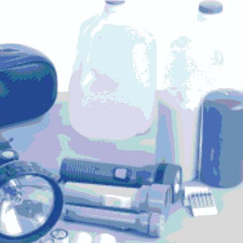
People with Access &                           and medical care. Some examples of these
                                               needs might be:
Functional Needs                               • People who are deaf or hard of hearing
Each person’s needs and abilities are            may need to make special arrangements
unique, but every individual can take            to receive emergency warnings.
important steps to prepare for all kinds of    • Single working parents and people with
emergencies and put plans in place. By           limited English proficiency may need help
evaluating your own personal needs and           planning for disasters and emergencies.
making an emergency plan, you can be             Community, faith-based, and cultural
better prepared for any situation.               groups may be able to help keep people
• Consider how a disaster might affect            informed.
   your individual needs.                      • People without vehicles may need to
• Plan to make it on your own, at least          arrange for transportation.
   for a period of time. It’s possible that    People with special dietary needs should
   you will not have access to caregivers,     take precautions to have an adequate
   medication or electricity.                  emergency food supply. For comprehensive
• Identify what kind of resources you use      information regarding AFN planning visit
   on a daily basis, like medications or       ready.nj.gov. Information is available for
   durable medical equipment, and what         consumers, service-providing agencies,
   you might do if they are limited or not     and government officials.
   available.                                  Additional Support
• Build a kit with your unique consideration   The Dept. of Human Services Division of
   in mind. What do you need to maintain       Mental Health and Addictions Services
   your health, safety, and independence?      Office of Disaster and Terrorism:
If you or someone close to you has a           http://nj.gov/health/integratedhealth/
disability or other access or functional       Office: 609-438-HEAL (609-438-4325)
need, you may have to take additional          Helpline:
steps to protect yourself and your family.
                                               1-877-294-HELP (1-877-294-4357)
Find out about individual assistance that
                                               1-877-294-4356 TTY (voice callers use
may be available in your community.
                                               7-1-1 NJ Relay)
Register in advance with the office
of emergency services, the local fire          Addictions Hotline of NJ:1-844-276-2777
department, and other government               NJ SNAP/Food Stamps: 1-800-687-9512
agencies or non-profit groups. Tell them of    or visit http://www.nj.gov/humanservices/
your individual needs or those of a family     dfd/programs/njsnap/
member and find out what assistance or         Medicaid Call Center: 1-800-356-1561
services can be provided.
                                               Work First NJ/General Assistance: 1-800-
Who are Individuals with Access &              792-9773 or visit http://www.state.nj.us/
Functional Needs?                              humanservices/dfd/programs/workfirstnj/
People with access and functional needs
may have disaster-related
needs before, during,
and after an incident in
functional areas, including
but not limited to:
maintaining independence,
communication,
transportation, supervision,
ready.nj.gov                                                                            7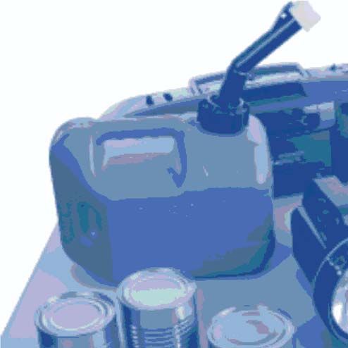
Travel Trailer/Mobile Home Safety
NO TRAVEL TRAILER OR MOBILE HOME – NO MATTER
HOW NEW IT IS – CAN BE A SAFE SHELTER FROM
STORM FORCE WINDS.

IF COUNTY OR STATE OFFICIALS TELL YOU TO EVACUATE:
• LEAVE AS SOON AS POSSIBLE.
• Make a Family Communication Plan. Tell someone outside of the storm area
  where you are going.
• Take emergency supplies, warm protective clothing, and blankets/sleeping
  bags to shelter.
• Protect your home by unplugging appliances and turning off electricity and wa-
  ter.
• Turn off the main electrical power switch.
• Turn off the main water valve and disconnect the hose.
• Turn propane tanks off.
• Lock up your travel or mobile home and leave.

DURING A HURRICANE OR TROPICAL STORM WATCH OR WARNING:
• Listen to radio/television for storm progress reports.
• Check emergency supplies.
• Fuel your car.
• Board up windows and check tie-downs on your travel trailer or mobile home.
• Turn refrigerator and freezer to coldest settings.
• Store drinking water.
• Review evacuation plan.

AFTER THE STORM
• Stay tuned to local radio or television for information from your local or state
  officials.
• Return home only after state or local officials advise that it is safe to do so.

!
8
    Any individual who lives in a travel trailer should pay close attention
    to radio and television reports to receive important information from
    local and state officials concerning hurricane precautions.                      !
                                                           NJ Hurricane Survival Guide
Plain Talk On Protecting Pets
Natural disasters, such as flash floods, hurricanes, or forest fires, and man-
made problems such as gas explosions, leaking tank cars, and terrorist
incidents, can arrive with little, if any, warning. The type of disaster will determine
whether to shelter in place or evacuate the area. Your county/local emergency
management coordinator will have the most current updates and recommendations
at the time of the disaster. This number can be found in the blue pages of your
telephone book. By developing a disaster action plan for yourselves and your pets,
you can improve the chances that all of you can make it through a disaster safely.
If you are ever instructed to evacuate, please remember your pets!
Take Steps to Protect Your Pets
Have a safe place to take your pets. Listen for public service
Do this research ahead of time, before announcements during a disaster that
a disaster strikes. Prepare a list of may instruct you to take your pets to a
emergency phone numbers, and keep it temporary emergency animal shelter.
handy. If your pet has any special needs, For these places, you must do the
such as a special diet or medication, or following:
is an exotic pet (including reptiles, birds, Get a portable pet carrier for each
and fish), consider their requirements in pet. These carriers should be large
your disaster planning before you need enough for the pet to stand up and
to evacuate these animals. turn around in. Get your pet used to
Ask a dependable friend or relative the carrier ahead of time. Snakes may
who lives some distance away if you be kept in plastic containers, and birds
and/or your pets can stay with them need their cages.
during an emergency. Have identification for each pet. Be
Contact hotels and motels outside sure your pet ALWAYS wears a well-
your immediate area to check policies fitted collar with proper identification,
on accepting pets during times of and has been micro-chipped or tattooed.
emergencies and any restrictions they ID tags and pet carriers should include
may have. your phone number(s) as well as the
Make arrangements with number of a contact outside the affected
trustworthy neighbors for pet care region.
if a disaster strikes and you cannot get
home in time to evacuate.
Find boarding kennels within and
outside your area. Know where they
are, who stays on the premises with the
animals in the event of a disaster, and
what provisions would be made if the
kennel should have to evacuate during a
disaster.
ready.nj.gov 9Prepare a Disaster Travel Kit For Your Pet
In case you must leave the area with In addition, sharp objects, downed
your pet, this kit should include: electric lines, fallen trees and other
debris, or contaminated water could
present real danger to your pet.
Copies of pet license, microchip,
Raccoons, skunks or other wild animals
tattoo and/or ID, photos of pet
may have entered the area and could
(from all angles and with owner(s)),
potentially be a danger to your pets.
and plastic bag with proof of
vaccination. If any animals are lost during the
disaster, contact veterinarians, humane
Proper size metal or plastic pet societies, pet shelters, and other
carrier facilities that might house animals.
Be prepared to identify and document
Leashes and obedience aids ownership when claiming lost livestock.
The United States Department of
Non-spill water and food bowls
Agriculture Missing Pet Network at www.
Pet foods, including special diets missingpet.net may be of assistance.
If you own horses, livestock,
Water in sanitized non-breakable or poultry, you need to develop
containers emergency evacuation plans for them
Motion sickness pills prescribed by also. http://www.nj.gov/agriculture/
your veterinarian, if needed animalemergency/prepare/livestock_
resources_preparing.shtml for livestock
Special medications, with resources, your county emergency
instructions management coordinator’s office, or
from the New Jersey Department of
Special needs items for exotic pets, Agriculture Division of Animal Health at
such as a heat source 609-671-6400.
Newspapers, paper towels, handy-
wipes, can openers, a flashlight, For More Information
and blankets
New Jersey Department of Agriculture:
http://www.animalemergency.nj.gov/
What to do when the “All Clear” Humane Society of the United States:
Sounds: www.hsus.org/disaster
Once the all clear has sounded and you New Jersey Veterinary Medical
and your pets return to your home, Association: www.njvma.org
be careful about allowing your pets
outdoors unattended and off leash. The
disaster may have altered familiar scents
and landmarks and your pet could easily
get confused and become lost.
10 NJ Hurricane Survival GuideHurricane Hazards...
High Winds
Hurricane-force winds can easily destroy
poorly constructed buildings and mobile
homes. Debris such as signs, roofing
material, and small items left outside
become flying missiles in hurricanes.
Extensive damage to trees, towers,
water and underground utility lines
(from uprooted trees), and fallen poles
cause considerable disruption.
The eye wall and innermost rain bands
of hurricanes are extremely dangerous
in that they can produce very localized
devastation. The strongest winds are
typically associated with the eye wall of
a hurricane. When winds of 111 mph
(category three) or more are expected
in an area, an extreme wind warning will Graphic courtesy of NOAA
be issued by the National Weather Service.
The strongest winds usually occur on the right side of the eye wall of the hurricane.
This can be seen in the wind analysis above from Hurricane Irene in 2011.
Wind damage increases dramatically as a storm grows stronger. A category four
hurricane with winds 131 to 155 mph, would be expected to cause 100 times the
damage of a category one storm.
Locations well inland
can still experience
destructive wind
damage. Wind
gusts can actually
increase inland due
to turbulence mixing
faster moving air to the
surface.
ready.nj.gov 11Hurricane Hazards... these areas, conditions could become
life-threatening.
Storm Surge • Follow directions of emergency
officials. Evacuation zones consider
many critical factors that affect public
safety; so evacuation zones can be
different from the areas shown on
the storm surge map. Storm surge
can sometimes cut off evacuation
routes, so do not delay leaving if an
Storm surge is a dome of water often 50 evacuation instruction is given for
to 100 miles wide that sweeps across the
your area
coastline along and to the right of where
the eye makes landfall. In general, the • Potential water depths are shown as
stronger the winds, the higher the storm above ground, not above mean sea
surge. If the hurricane makes landfall level or normal tide levels. Local land
during high tide, the impact is even elevations are taken into account,
greater. along with tides, when creating the
Storm surge does not take into account map. However, the depicted water
wave height, which is added on the top levels do not account for rainfall or
of the storm surge, to produce even waves.
more destruction. The size, speed, and • Storm surge is not just a coastal
strength of a storm and the angle it threat. Storm surge can cause
approaches the coast contribute to the dangerous flooding well inland from
damage storm surge can cause. the coast, and the map will show this
Starting in 2014, the National Hurricane potential flooding.
Center (NHC) and National Weather • Storm surge can cause water levels
Service (NWS) will be communicating to rise quickly and flood large areas—
information regarding the potential sometimes in just minutes. You could
impacts of storm surge. The “Potential be left with no time to take action
Storm Surge Flooding Map” is an
if you haven’t already evacuated
experimental National Weather Service
as instructed. During the peak of
(NWS) product. According to the NHC,
a storm surge, it is unlikely that
“storm surge is often the greatest threat
emergency responders will be able to
to life and property from a tropical storm
or hurricane.” The map will contain reach you if you are in danger.
information regarding areas that might
be potentially impacted by storm surge,
and how high above ground the water
could reach in those areas.
Keep in the mind the following
information regarding storm surge:
• Storm surge maps may reflect a
range of possible impacts for regions
of New Jersey. For someone living in
12 NJ Hurricane Survival GuideHurricane Hazards...
Flooding
A FLASH FLOOD occurs within a few hours (usually
less than 6 hours) of heavy or excessive rainfall, a
dam or levee failure, or the sudden release of water.
A FLOOD develops more slowly, normally taking
more than 6 hours.
Many flash flood fatalities occur at night.
SIX INCHES of fast-moving water can knock you off your feet.
TWO FEET of rushing water can carry away most vehicles, including SUVs and
pickups.
Floods are long-term events and may last days, weeks, or even longer! The
National Weather issues flood watches well ahead of expected arrival. This is the
time to make preparations, including planning an escape route if you live in a flood-
prone area.
Flash flood warnings and area-based flood warnings are issued as tropical systems
make landfall. Area-based flood warnings may continue for days or weeks until
flood waters have receded.
Most flooding deaths occur in automobiles. Always avoid driving
into flooded areas! Remember to “Turn Around, Don’t Drown.”
ready.nj.gov 13Hurricane Hazards...
Tornadoes
Hurricanes can produce tornadoes as they move onto land. These tornadoes add
to a hurricane’s destructive power. The National Weather Service will issue tornado
warnings when they are spotted on Doppler radar or reported.
Most tornadoes associated with hurricanes are less intense than those that occur
in the plains, typically EF0 to EF1 on the new Enhanced Fujita Scale. However, the
effects of tornadoes added to the larger area of hurricane-force winds can produce
substantial damage.
ENHANCED FUJITA SCALE: The
National Weather Service (NWS) uses
the EF-Scale to assign a tornado a
rating based on estimated wind speeds
and related damage.
3 Second Wind
EF Rating
Gust (MPH)
0 65 - 85
1 86 - 110
2 111 - 135
3 136 - 165
4 166-200
5 Over 200
14 NJ Hurricane Survival GuideHurricane Hazards...
Rip Currents
Unlike most hazards
associated with
hurricanes, rip currents
differ in that they can be
a threat days in advance
of a hurricane, and
cause deaths even when
there is no threat of a
hurricane strike in our
area.
Rip currents are powerful,
channeled currents of water
flowing away from the
shore. A Rip current is often
not seen by a swimmer
before being caught in its
grip. They can be present
on what appears to be a
perfect day at the beach
with bright sunny skies and
no hint of danger.
Although a variety of factors
can cause rip currents,
hurricanes produce them
due to a powerful ocean
swell wave that their strong
winds generate. The swell
wave radiates outward from
the center of the storm
and can affect beaches
thousands of miles away. Graphic courtesy of NOAA
Rip current safety signs are placed along area
beaches. For more information on rip currents, visit
www.ripcurrents.noaa.gov
ready.nj.gov
ready nj gov 15information about housing rental
After a Hurricane... resources at www.fema.gov.
• Continue listening to a NOAA weather • Drive only if necessary and avoid
radio or the local news for the latest flooded roads and washed-out bridges.
updates. Stay off the streets. If you must go
• Stay alert for extended rainfall and out, watch for fallen objects, downed
subsequent flooding even after the electrical wires, and weakened walls,
hurricane or tropical storm has ended. bridges, roads, and sidewalks.
• If you have become separated • Keep away from loose or dangling
from your family, use your family power lines and report them
communications plan or contact FEMA immediately to the power company.
or the American Red Cross. • Walk carefully around the outside of
• FEMA has established the National your home and check for loose power
Emergency Family Registry and Locator lines, gas leaks, and structural damage
System (NEFRLS) which has been before entering.
developed to help reunite families who • Stay out of any building if you smell
are separated during a disaster. The gas, if floodwaters remain around the
NEFRLS system will enable displaced building, or if your home was damaged
individuals the ability to enter personal by fire and the authorities have not
information into a website database declared it safe.
so that they can be located by others • Inspect your home for damage.
during a disaster. Take pictures of damage, both of the
• The American Red Cross also maintains building and its contents for insurance
a system called “Safe and Well” (www. purposes. If you have any doubts about
redcross.org/safeandwell) which can safety, have your residence inspected
help you register yourself safe or find by a qualified building inspector or
family members. Go online to inquire, structural engineer before entering.
call 2-1-1 or 800-RED-CROSS for more • Use battery-powered flashlights in
information. the dark. Do NOT use candles. Note:
• If you evacuated, return home only The flashlight should be turned on
when officials say it is safe. outside before entering - the battery
• If you cannot return home and have may produce a spark that could ignite
immediate housing needs, text leaking gas, if present.
SHELTER + your ZIP code to 43362 • Watch your pets closely and keep them
(4FEMA) to find the nearest shelter in under your direct control. Watch out
your area (example: shelter 12345). for wild animals, especially poisonous
You can also call 2-1-1 or go online snakes. Use a stick to poke through
to www.redcross.org to find shelters. debris.
Smartphone users can find Red Cross • Avoid drinking or preparing food with
shelters with the Hurricane App. tap water until you are sure it’s not
• For those who have longer-term contaminated.
housing needs, FEMA offers several • Check refrigerated food for spoilage. If
types of assistance, including services in doubt, throw it out.
and grants to help people repair their
• Wear protective clothing and be
homes and find replacement housing.
cautious when cleaning up to avoid
Apply for assistance or search for
injury.
16 NJ Hurricane Survival GuideThe Saffir-Simpson Hurricane Wind Scale is a 1 to 5 rating based on a hurricane’s
sustained wind speed. This scale estimates potential property damage. Hurricanes
reaching Category 3 and higher are considered major hurricanes because of their
potential for significant loss of life and damage. Category 1 and 2 storms are still
dangerous, however, and require preventative measures.
Sustained
Category Type of Damage Due to Hurricane Winds
Winds
Tropical 39-73 mph Scattered trees down, scattered power outages, some
Storm 63-117 km/h roads blocked by downed trees and power lines.
Saffir-Simpson Hurricane Wind Scale
74-95 mph Very dangerous winds will produce some damage: Well-
64-82 kt constructed frame homes could have damage to roof,
shingles, siding, and gutters. Large branches of trees will
1 119-153 snap and shallowly rooted trees may be toppled. Exten-
km/h sive damage to power lines and poles likely will result in
power outages that could last a few to several days.
96-110 mph Extremely dangerous winds will cause extensive damage:
83-95 kt Well-constructed frame homes could sustain major roof
and siding damage. Many shallowly rooted trees will be
2 154-177 snapped or uprooted and block numerous roads. Near-
km/h total power loss is expected with outages that could last
from several days to weeks.
111-129 mph Devastating damage will occur: Well-built framed homes
96-112 kt may incur major damage or removal of roof decking and
gable ends. Many trees will be snapped or uprooted,
3 178-208 blocking numerous roads. Electricity and water will be
km/h unavailable for several days to weeks after the storm
passes.
130-156 mph Catastrophic damage will occur: Well-built framed homes
113-136 kt can sustain severe damage with loss of most of the roof
structure and/or some exterior walls. Most trees will be
4 209-251 snapped or uprooted and power poles downed. Fallen
km/h trees and power poles will isolate residential areas. Power
outages will last weeks to possibly months. Most of the
area will be uninhabitable for weeks or months.
157 mph or Catastrophic damage will occur: A high percentage of
higher framed homes will be destroyed, with total roof failure
137 kt or and wall collapse. Fallen trees and power poles will iso-
5 higher late residential areas. Power outages will last for weeks
to possibly months. Most of the area will be uninhabitable
252 km/h or for weeks or months.
higher
NOTE: These damage descriptions pertain to the effects of wind only.
Heavy rains, which can occur at any level, can cause river flooding and/
or flash flooding anywhere in New Jersey, regardless of storm intensity.Agency Contact Information
Scan this with your smartphone to go
to the ready.nj.gov website.
American Red Cross NJ Dept. of Environmental Protection
www.redcross.org If residents need to report an
1-800-RED-CROSS environmental incident impacting the
state, please call the DEP 24-Hour Hotline
NJ Office of Emergency Management at: 1-877-WARN-DEP.
ready.nj.gov
NJ Office of Homeland Security & NJ Dept. of Health
Preparedness http://www.nj.gov/health
www.njhomelandsecurity.gov Directory of Local Health Departments in
Tips & Leads: 866-4-SAFE-NJ New Jersey:
https://www.nj.gov/health/lh/
NJ Office of the Attorney General documents/LocalHealthDirectory.pdf
http://nj.gov/oag
Consumer Affairs: 800-242-5846 NJ Dept. of Human Services -
NJ Dept. of Transportation Division of Aging Services
www.state.nj.us/transportation https://www.state.nj.us/humanservices/
For Motor Vehicle Services, the general doas/home/
customer service number is 609-292- Senior Services and Benefits – NJ EASE
6500 or, for the hearing impaired, 609- 1-877-222-3737
292-5120.
Centers for Disease Control and
For maintenance issues such as
Prevention
malfunctioning traffic signals and
https://emergency.cdc.gov/
potholes, direct calls to 1-800-POTHOLE.
Note: if you have a pothole damage FEMA
claim you must call 609-984-7294. www.fema.gov
Find all the necessary information
regarding area road conditions by dialing NJ Poison Control
511 or toll free 1.866.511.NJDT (6538). www.njpies.org
The site offers a map indicating flooded 1-800-222-1222
or obstructed roads and detours. You can
also log on to: www.511nj.org. Volunteers and Donations
www.HELPNJNOW.org
NJ 2-1-1
Residents can dial 2-1-1, toll-free, for
preparedness & disaster-related info 24/7 or
www.nj211.org
Effective 2020You can also read