Improving Telecommunications for Atihau Whanganui and surrounding rural communities - 30 June 2012
←
→
Page content transcription
If your browser does not render page correctly, please read the page content below
Improving Telecommunications
for Atihau Whanganui and
surrounding rural communities

30 June 2012

Telco2 Limited   3/123-125 Austin St. Mt. Victoria, Wellington 6011   T 04 913 8123 M 027 502 8230   jon.brewer@telco2.co.nz   http://telco2.co.nz/

Improving Telecommunications for Atihau Whanganui and Surrounding Communities 1
Atihau Whanganui Incorporation
Māori owned Atihau Whanganui Incorporation has been farming Mãori land in the Whanganui River Valley since the 1970s.
The group manages nearly 42,000 hectares of land used for pastoral farming, forestry, and dairy, and maintains more than
110,000 stock units. Some sites have RFID enabled technologies such as automated weighing crates and drafters, and all
use the FarmIQ system “in the cloud” for farm management. A satellite system connects eight Atihau farms, but does not
connect to or otherwise benefit the surrounding communities. Four Atihau locations have ADSL broadband connections.
Atihau Whanganui Incorporation
Farms are clustered around
Raetihi, to the South and East
Atihau’s Community
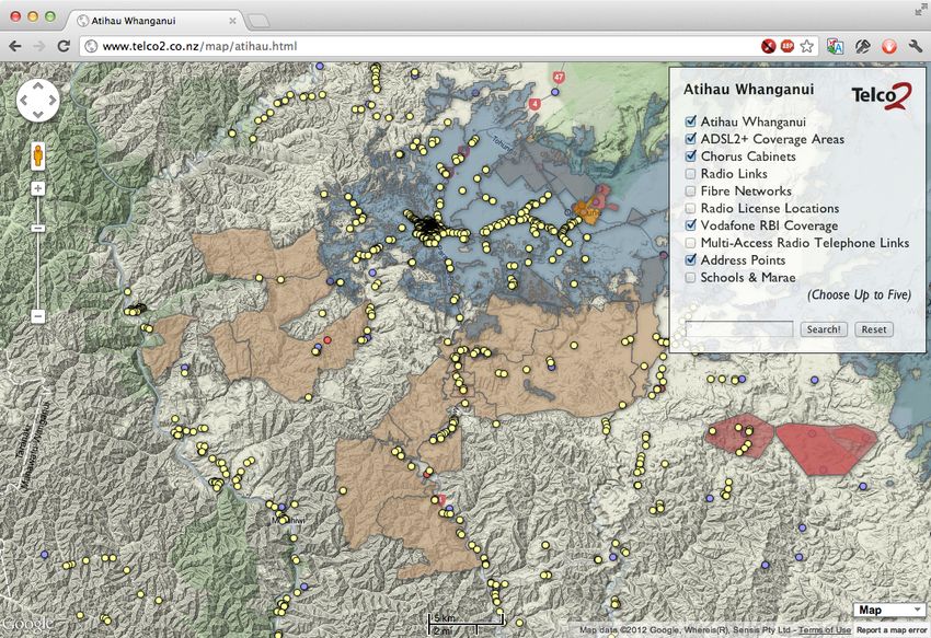
The majority of people in Atihau’s Community live in Ohakune and Raetihi. Smaller settlements around the farms include
Rangatatua, Tohunga Junction, Waimarino, Pipiriki, Ranana, and Matahiwi, and groups of people live in houses along
Whangaehu Valley Road and State Highway 4. Considering meshblock level data from the 2006 census, and excluding
Ohakune, there were only 1,100 people living in 390 households in meshblocks on or adjacent to Atihau land. All households
in the area (including those outside the scope of this study) are indicated with yellow dots in the image below.
Telco2 Limited 1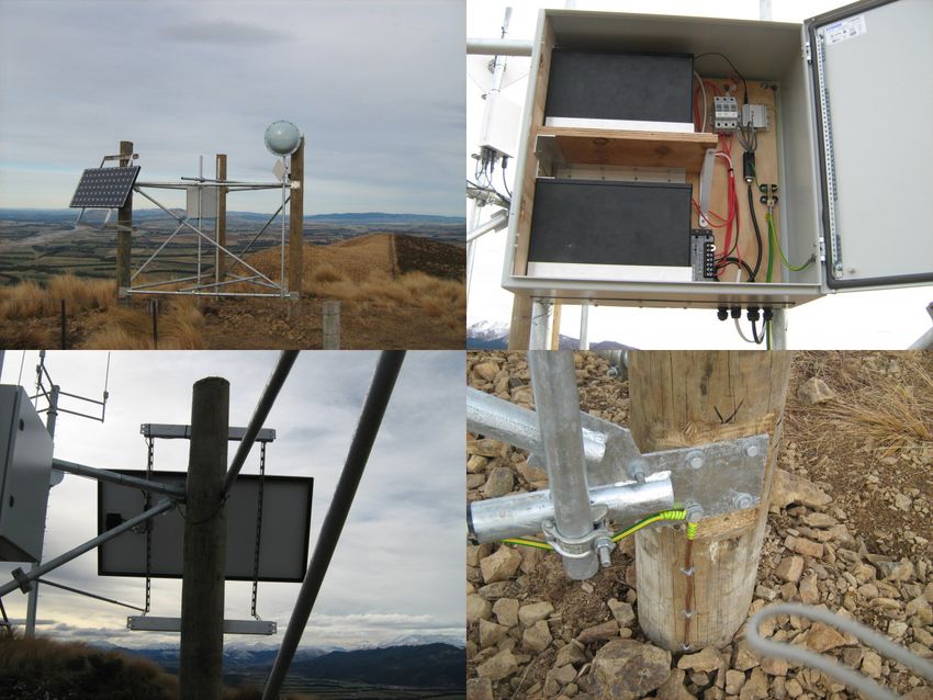
Improving Telecommunications for Atihau Whanganui and Surrounding Communities                                                                                                               2

Telecommunications Services for Remote Communities
With around two people per square kilometre across the region, providing telecommunications services to Atihau and their
rural neighbours is difficult. The chart below, derived from a 2003 submission to the IEEE by Canada’s Communications
Research Centre, shows relative cost and complexity curves of delivering service by various technologies. From their
findings, we can infer Raetihi is around the smallest community for which providing fixed line telecommunications services is
a viable commercial, and most other households would be best serviced by fixed wireless or satellite.

                                                                              Atihau Communities                                        Raetihi
                                                                                                                                                                Hamilton

                                                      100
                                                                                                                               Cable Modem
                                                      90
                       Relative complexity/cost (%)

                                                      80
                                                                                                                                                  Fibre Optic
                                                      70
                                                                                                                        ADSL
                                                      60
                                                                                                    Fixed Wireless
                                                      50
                                                                  Satellite

                                                      40

                                                      30

                                                      20

                                                      10

                                                       0
                                                            0.1                  1                       10                       100                1,000
                                                                                               Population density (per km2)

Existing Fixed Line Infrastructure
Telephones had been installed in Raetihi by the time of the 1918 bush fire, but it took until the 1980s before most remote
communities received modern single-user systems. Since the privatisation of Telecom in 1990, these systems have been
well maintained, but not necessarily upgraded to support broadband. Fibre optic cables have been installed in some
locations, but are not always configured for high bandwidth use or even connected to a national fibre backbone. The image
below shows fibre availability, and points out a section of fibre that is isolated from the backbone by a radio link.

 Fibre connected
 to Raetihi

                                                                                                                                                                           Isolated Fibre
                                                                                                                                                                           Loop

Telco2 Limited                                                                                                                                                                              2
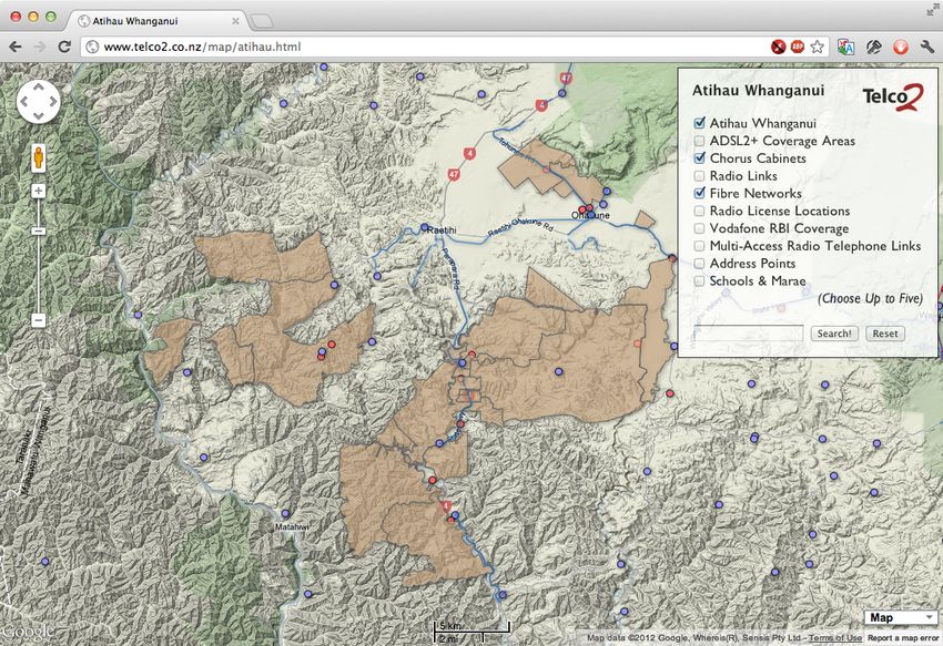
Improving Telecommunications for Atihau Whanganui and Surrounding Communities                                                   3

While telephone service is delivered to these communities via copper local loops, the backhaul in place for these loops is
most often not fibre, but copper or radio. Chorus does not publish maps of their copper backhaul links as they do for fibre,
but when radio links are used, the details are published by the Ministry of Economic Development’s Radio Spectrum
Management group. The image below shows all radio links licensed in the area, and some unlicensed links operated by a
local wireless provider. Purple coloured lines are low-frequency radio links, yellow are unlicensed wireless links, and green are
high frequency microwave links. Line thickness relates to the amount of spectrum in use; narrow lines indicate a low capacity
link and wide lines indicate high capacity links.

Communications over radio and isolated fibre loops does not generally support broadband, and in fact Chorus do not claim
broadband availability across any of the Atihau area. In cases where high capacity microwave links are licensed, broadband
is sometimes supported by a “Conklin-Intracom FASTmux”, also known as a
Conklin, and pictured to the right. These small, rack mount devices are
modular and each module supports four ADSL1 circuits, allowing the
regulated BUBA product, but not the regulated EUBA product. Chorus have
around 2,200 Conklin deployments in rural areas, but do not have coverage
information and will not release details on where they are deployed. In an email
to the Commerce Commission in May 2012, Craig Young of Chorus indicated
that some of these details may be released in October.

Rural Broadband Initiative
The government’s Rural Broadband Initiative (RBI) was designed primarily to improve broadband connectivity to rural
schools, and is providing Chorus funding for installing around 3,100km of new fibre optic cables. A secondary goal of the
RBI is improving broadband connectivity to the communities surrounding these schools, and improving cellular coverage to
rural areas in general. Vodafone has been funded to build 154 new cellphone towers and upgrade an additional 387 towers
to support fixed 3G broadband for houses beyond the reach of ADSL, and through the RBI Chorus will connect these
towers with fibre and high capacity Microwave radio.

In addition to RBI funded improvements, many communities will receive upgraded ADSL2+ broadband as Chorus upgrades
cabinets passed by new fibre. Around 1000 cabinets will be upgraded, delivering better service to nearly 105,000 lines.

Telco2 Limited                                                                                                                  3
Improving Telecommunications for Atihau Whanganui and Surrounding Communities                                                   4

Only the town of Raetihi and immediate neighbourhoods will receive an upgrade of ADSL2+ broadband as a part of the RBI.
Vodafone fixed wireless upgrades and new cellular coverage will be much more significant, but still geographically limited by
the rough terrain of the area. The next images show ADSL2+ in green and cellular and wireless coverage in blue.

                                                                                       Vodafone Fixed Wireless Coverage

         New RBI ADSL2+ Coverage

Not all schools will be receiving fibre through the RBI, and not all communities will be able to take advantage of upgraded
ADSL or Vodafone wireless, or new cellular coverage. The following image shows households superimposed on a coverage
map which includes the Atihau properties. Only the AWHI Dairy property West of Ohakune will be completely covered by RBI
and cellular coverage broadband, while the majority of Atihau’s farms and neighbouring communities will be missed.

                                                                                    AHWI Dairy: Covered

                        AHWI Pastoral and Forestry and Surrounding Communities: Not Covered by the RBI

Telco2 Limited                                                                                                                  4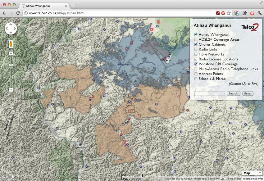
Improving Telecommunications for Atihau Whanganui and Surrounding Communities 5
A separate program exists to connect the most remote 60 schools in the country via alternative wireless providers, called the
“Remote Schools Broadband Initiative” (RSBI). Araneo, Gisborne.Net, and Inspire Net were selected to connect schools with
10mbps symmetric wireless - a modest speed but far faster than satellite options.
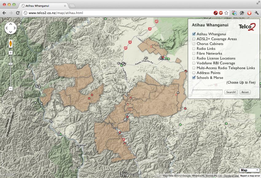
The next image shows the schools (green dots) in the Atihau area, and notes the provider for each.
Orautoha: Inspire Net
Ohakune: RBI Fibre
Raetihi: RBI Fibre
Rangiwea: RBI Fibre
Ngamatea: Inspire Net
Whanganui Awa: Inspire Net
RSBI Spill Over
The RSBI program does not provide for connectivity to communities, but some providers have decided to bring consumer
level services in to the areas around RSBI schools. The map below displays the coverage Inspire Net expects to be provided
as they build new infrastructure to cover Whanganui Awa, Ngamatea, and Orautoha Schools. This coverage is confidential
and commercially sensitive, and use has been granted by Inspire Net for viewing by Nga Pu Waea and Te Puni Kokiri only.
Inspire Net Commercial In Confidence
The red areas outlined above are where new coverage will intersect with area residents. Of note to AWHI, two properties
currently on satellite could potentially be serviced by Inspire Net’s existing network. This could provide a quick and easy trial
of the service while meeting an immediate need.
Telco2 Limited 5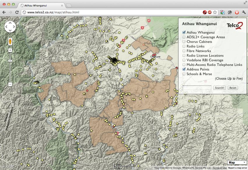
Improving Telecommunications for Atihau Whanganui and Surrounding Communities                                                   6

Cellular Coverage

Both Telecom and Vodafone have existing cell sites providing excellent coverage of the Waiouru to Raetihi corridor, with fair
to good coverage continuing North to National Park. Telecom’s footprint, displayed below in purple, dips slightly further
South than Vodafone’s, but coverage by Vodafone is set to catch up with the installation of their new RBI towers.

Both carriers provide coverage of Atihau farms and communities restricted to hilltops and major roads, with minor roads,
houses in valleys, and all communities along the Whanganui River valley missing out on cellular service.

Where To Improve?
Upcoming network build by Inspire Net will bring high speed wireless broadband to some of the communities surrounding
Atihau Whanganui. New Vodafone RBI towers will bring good cellular coverage and fixed wireless broadband to the northern
ends of Tawanui and Ohotu farms. Unfortunately large blocks of farmland and many communities will be left without
broadband or cellular coverage. Given the growing use of technology on the farm, and the great benefits to the health and
safety of workers who have mobile coverage in remote areas, improvement should concentrate on bringing high speed
broadband to all farm offices and staff homes, and mobile coverage to as much of the farms as financially viable.

Telco2 Limited                                                                                                                  6
Improving Telecommunications for Atihau Whanganui and Surrounding Communities                                                  7

Principles of Remote Communications
Tens of millions of dollars have been poured in to rural and remote communications projects over the last decade, and one
by one those projects have been abandoned. Kordia’s Extend, Woosh’s Southland network, and Counties Power’s Wired
Country networks were all nearing obsolescence by the time they were deployed, both in terms of technology and
configuration. Expensive, proprietary infrastructure was installed on towers with the expectation that hundreds of subscribers
would connect to each sector and pay a premium to use a small amount of data. Today none of these networks are in
widespread use or even being upgraded to modern standards.

A new model for remote communications should learn from both the technical and commercial failings of these projects, and
design for decades of use. This section will deal with solution principles - the essential issues to consider when designing
remote communications networks. These principles are important to acknowledge when contracting or cooperating with a
provider of remote communications.

Plan for Growth
Over the last decade, Cisco’s Visual Networking Index has tracked the growth of Internet traffic around the world. It has
consistently predicted year-on-year growth rates, and has never been shown to over-estimate growth. It shows New
Zealand traffic growth tracking that of the US and Western Europe at a 34% compound annual growth rate, but with average
utilisation four or five years behind the US. The model below shows New Zealand four years behind the US, with 2012
average utilisation of 12GB per month.

Given a demand for 12GB/month/user, and with the understanding that around 18% of monthly traffic caps will be
consumed during “peak hours” of 8-10PM, a network engineered to keep up with today’s loading requirements must have
around 75kbps of capacity per user to start, a figure that will grow 34% year on year, with no end in sight.

Any network design must take into consideration both its predicted loading and a 34% compound annual traffic growth rate.

Eight Year Upgrade Cycles
2004 saw the first mass production of 802.11a/g Wi-Fi chipsets, with their revolutionary peak speeds of 54mbps. Many are
still in operation today, but are beginning to show their age. 2012 will see the first mass produced 802.11ac chipsets
operating at 867mbps. In eight years the speed of wireless technologies has increased by more than an order of magnitude.

Telco2 Limited                                                                                                                 7
Improving Telecommunications for Atihau Whanganui and Surrounding Communities                                                       8

Cellular technology operates on similar time spans. Telecom’s CDMA network was launched in 2001 and it’s XT network was
launched eight years later in 2009. The difference in their capabilities is tremendous.

A network deployed today should be designed to cope with peak loads in its last year before retirement. For a broadband
network deployed in 2013, that means 2021 capacities of just over 1mbps per subscriber will be required to meet demand
during peak hours. Access equipment has a finite lifespan, but rural telecommunications requirements do not.

Build Long Lasting but Inexpensive Infrastructure
A piece of steel pipe, a couple of sacks of concrete, stock fencing and some number 8 wire is the standard for most rural
wireless operators in New Zealand. Unfortunately such a strategy often fails within a few years. Wireless network equipment
may only have a useful lifespan of eight years, but the infrastructure around it should last much longer. Utility poles and
towers should last between 25-40 years, as should equipment enclosures. Photovoltaic panels, rectifier systems, and high
quality batteries should all last through at least two eight year network hardware cycles, if not three. Stock fencing and
access tracks should be built with the assumption they will be used for decades. Building proper infrastructure can double
the initial cost of a rural telecommunications site, but will pay dividends over the long term.

The three radio towers pictured above have roughly the same type and value of wireless and installed on them. The Scorch
and Primo sites use two 80W solar panels to Araneo’s one 160W panel. Charge controllers and battery banks for the Scorch
and Primo sites are unknown, but the Araneo site has 17 days of battery capacity, and a panel that will provide a charge
even in cloudy weather. Around $3k was spent on the Araneo structure of utility poles and 76M galvanised steel and another
$3k on the power system. The Scorch tower and enclosure was welded together with free bits from a scrap yard. Taranaki’s
Primo used a 50mm diameter steel water pipe mast and 34mm steel pipes for bracing.

All three sites will perform equally well in the first few years of use, but the while the first was designed for thirty years of
operation, both the second and third will be struggling in five. Even though the Primo site is tidy, their light weight assembly
will flex and vibrate in high winds, leading to problems with equipment and eventual failure of the tower.

Key to the economics of remote communications, all three examples come in at under $10,000 per site as deployed. This
amount is around 10% of the least expensive rural site built by 2Degrees, Kordia, Telecom, Vodafone, or Woosh, and can be
recovered over the long term on remote sites with only a handful of users.

Use Licensed Fixed Wireless for Backhaul
Traditional cellular access networks, and large wireless networks like Woosh and Kordia use fibre or licensed microwave for
backhaul. In remote networks, both are impractical. Fibre is expensive to deploy for just a few people. Licensed Microwave
can require large antennas that can mean significant investments in tower engineering and installation, and uses licenses
resulting in additional fixed operational expenses. Unlicensed linking is used by most rural carriers, but while appropriate for
general broadband use, is not able to provide the quality of service required by cellular providers.

Telco2 Limited                                                                                                                      8

Improving Telecommunications for Atihau Whanganui and Surrounding Communities                                                   9

Fixed wireless spectrum is plentiful in 2GHz, 2.2GHz, 2.3GHz, and 2.5GHz TDD bands, and the 3.5GHz FDD band. A broad
selection of multi-access equipment exists in 2.3, 2.5. and 3.5GHz and can be had in proprietary systems, WiMAX (802.16)
systems, or TD-LTE systems. Antennas can be relatively small and easy to align, and a number of small repeater towers can
be fed from a single high site. Should licensed fixed wireless spectrum be available to a provider, it is the best choice for
providing backhaul to remote tower sites.

Build Access Networks With Standards Based Equipment
Rural access networks built by Woosh, Kordia, and Wired Country were locked in to expensive, proprietary subscriber units.
Adding new subscribers to those networks today would be difficult, if not impossible. Conversely, rural networks built by
ThePacific.Net, Inspire Net, and Araneo around the same time were built on standards based equipment. Hundreds of
vendors around the world make subscriber units that could be used with these networks today.

The specific standards recommended for a new rural network are the IEEE 802.11 series, GSM technologies, or 3GPP
technologies in common band plans; for example UMTS or FD-LTE equipment in Bands 1 or 3, or TD-LTE in band 40.

Solution Options
Four options are presented below, ranging from a strict hands-off contract model through to a scenario where AWHI would
build, own, and operate its own telecommunications infrastructure. A basic evaluation is made of the strengths and
weaknesses of each model, and capital and operational expenses are discussed.

Engage a Regional Wireless Internet Service Provider (WISP)
Almost every region of New Zealand has a local or regional wireless WISP. They range in size from a guy and his dog to
teams of dozens of employees. The following list provides the largest WISP in each region, from North to South.

      • Northland: Uber Net
      • Auckland: Bush Wireless
      • Waikato: No8 Wireless (nee Ruralink)
      • Bay of Plenty: NetSmart
      • Gisborne: Gisborne.Net
      • Hawke’s Bay: Now (nee Airnet)
      • Taranaki: Primo Wireless
      • Manawatu-Whanganui: Inspire Net
      • Wellington/Wairarapa: Wiz Wireless
      • Tasman/Marlborough: NetSolutionz (nee ThePacific.Net)
      • West Coast: Zelan Wireless
      • Canterbury: Amuri Net
      • Otago: WIC (Wireless Internet Connections)
      • Southland: Woosh Wireless
Across the Whanganui River Valley and Atihau properties, Inspire Net is the only established provider. Inspire are a full-service
telecommunications provider offering Internet and phone service over their own fibre and wireless based network. Their rural
wireless network is unlicensed, based on hardware from manufacturers Mikrotik, Trango, and Ubiquiti, and is run from more
than 150 tower sites across the Manawatu, Wairarapa, and Whanganui regions. Inspire’s voice offerings are based on Voice
over Internet Protocol (VoIP). They are also a reseller of Chorus, and can provide connectivity via Chorus ADSL or fibre.

Inspire offer peak-rate connectivity of 5mbps/1mbps, or 5mbps/5mbps with low but unpublished contention rates, and data
caps of between 1-2000GB/month. Business wireless plans start at $170/month, and include 20GB of data. While this
monthly charge is 40% higher than Atihau’s existing satellite service, it is lower than Farmside’s nearest equivalent current
plan (Satellite 2012 Pro), which offers only 1/3 the data cap.

A radio tower operated by Inspire at Hukaroa has the ability to connect the AWHI Dairy, Tohunga, and both Waipuna Station
locations. A forest interrupts an otherwise good terrain path to the two Ohotu Station locations. As all except the Waipuna
locations have existing ADSL broadband, Inspire service from an existing tower will only be attractive in two cases.

Telco2 Limited                                                                                                                  9
Improving Telecommunications for Atihau Whanganui and Surrounding Communities 10
Three more new radio towers would be required in order to provide basic broadband service to the eight other Atihau
locations on satellite plans, as shown in the illustration below. Blue ovals are existing sites, light orange ovals are Atihau sites
currently on satellite, green are sites on ADSL, and bright orange ovals represent required new towers.
Tohunga Station
Bruce Thompson
Chorus
ADSL
AWHI Dairy
Stephen Wilson
Ohotu Station
Dean Francois
Ohotu Station
Inspire Existing Site
Vacant
Hukaroa 1
Proposed New Site
Te Pa Station Dana Blackburn
Waipuna Station
Wayne Brownlie
Waipuna Station Te Pa Station
Mike Amey Larry Walker
Tawanui Station
Steve Tapa
Whatarangi
Murphy Peehi
Proposed New Site Farm Services Asst
Ohorea NW2 Rodney O'Neill
Ohorea Station
Rex Martin
Papahau Station
ANO
Proposed New Site
Papahau Station
Proposed New Site Papahau Station
Papahau Passive Bruce McDougal
In discussions with James Watts at Inspire, I was informed that Inspire will build a new radio tower in any location that sees
their existing network where they are guaranteed a minimum revenue stream that meets their internal financial targets. This
typically means twenty residential broadband connections, five business connections, or some balance of the two for each
tower. They require free or near-free access to land to build their rural towers, but provide their own quad bikes for
maintenance and use solar power for their sites. In order to secure new towers to service Atihau locations currently on
satellite, the company has three likely options, all subject to negotiation:
• Sign up enough Atihau neighbours to Inspire’s service to meet Inspire’s financial targets
• 15 new subscribers at $37.50/month might be required on top of Atihau’s 10 business connections
• Atihau’s up-front commitment would be $3k, OpEx would jump from $1220/month to $1700/month ex GST
• Connect 14 locations to Inspire’s business broadband plan
• Atihau’s up-front commitment would be $4.2k and OpEx would jump from ~$1460/month to $2380/month
• Subsidise Inspire’s tower build
• Ten sites would connect to Inspire. OpEx on these sites would jump from $1220/month to $1700/month ex GST
• Inspire would likely seek around $10k in build subsidy in addition to up-front installation charges.
• Inspire’s published rate card shows a 12 month minimum contract period for business connections
• Given average NZ traffic use, Atihau should budget for a $20/month/farm data cap upgrade in years 2 & 3
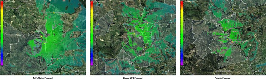
Of the three new sites required, only the one at Te Pa Station provides significant community benefit, with around 30
properties covered in addition to those required by AWHI. The site designated Ohorea-NW-2 covers fifteen properties in
addition to the three Atihau locations. The site at Papahau covers only Papahau Station, and with a passive repeater (around
$1,500 installed) will cover Bruce McDougal’s office. The image below shows the coverage of the three required sites.
Telco2 Limited 10Improving Telecommunications for Atihau Whanganui and Surrounding Communities 11
Inspire’s service, like that of most regional WISPs, is vastly superior to even the best of satellite broadband, and usually
outperforms rural ADSL in cases where the exchange or serving cabinet is more than 2km away. It is still a traffic-limited
service, which while acceptable for some businesses, may not be acceptable for companies who move their businesses in
to the cloud. For that, a solution with dedicated bandwidth and no caps is required.
The Inspire service as discussed above provides little spill-over benefit to the community in terms of increased access to
services. Only the fifteen properties around Ohorea have no other access to broadband. It also does not bring the possibility
of mobile coverage.
Inspire design for growth by installing access and backhaul equipment far faster than the 5mbps circuits they sell. They have
progressively upgraded the equipment on their older wireless sites in cycles quicker than eight years to keep pace with their
customers’ ever growing demand for data. They have not however invested in long-lasting sites with utility grade power
infrastructure or licensed backhaul, as the cost of such an investment would limit their growth. While Inspire provides a great
level of service to its business and residential customers, none of the mobile carriers are interested in cooperating with
Inspire or using their sites or backhaul for providing rural cellular coverage.
Engage an Open Access Wireless Carrier
State Owned Enterprise Kordia and Araneo, a subsidiary of sharemarket listed TeamTalk, are New Zealand’s two open
access wireless carriers. They both provide wireless access unbundled from Internet and telephone access, a product suited
mainly for resale by Internet Service Providers or integration by large companies. While Araneo provides a generally available
rural focussed product, Kordia do not have a current rural product since withdrawing their Extend product from the market.
Such wireless services are sold with committed information rates, typically between 2mbps and 100mbps. Committed rates
are offered for businesses who require the full capability of their service to be available all the time. The table below
compares committed rates between services.
Service Peak Download Rate Peak Upload Rate Committed Rate Up/Down
Araneo 2mbps Rural 2,000 kbps 2,000 kbps 2,000/2,000 kbps
Araneo 5mbps Rural 5,000 kbps 5,000 kbps 5,000/5,000 kbps
Chorus EUBA180 ADSL up to 24,000 kbps up to 1,400 kbps 180/180kbps
Chorus UBA ADSL up to 24,000 kbs up to 1,400 kbps 45/45kbps
Farmside Lite Satellite 2,000 kbps 1,000 kbps N/A
Farmside Regular/Plus/Pro Unknown Unknown N/A
Inspire Lite 5,000 kbps 1,000 kbps N/A
Inspire Faster Upload 5,000 kbps 5,000 kbps N/A
Vodafone RBI Wireless 5,000 kbps 512 kbps 45/45kbps
New Zealand’s largest corporate farmer, State Owned Landcorp Farming, contracts Araneo to provide 2mbps and 5mbps
connectivity for all of its farms nationwide. Given CEO Chris Kelly’s public comments about budgeting $500k for broadband
connectivity for Landcorp’s Farms, it can be concluded they spend around $400/month per farm for what is essentially a
private network between the sites.
Telco2 Limited 11Improving Telecommunications for Atihau Whanganui and Surrounding Communities 12
A network for Atihau would, similar to the Inspire solution discussed above, use Araneo’s site at Hukaroa as a linking
platform. Unlike Inspire’s site, Araneo’s Hukaroa installation has mains power and licensed microwave backhaul, and has a
four hour fault response time in place for its primary user, NZDF. Since Araneo is a wireless provider and not an ISP, a likely
configuration would have the area’s farms linked to a central hub at the Dairy Unit, where an ISP connection via Chorus
VDSL or HSNS could provide Internet connectivity for all of the facilities. The diagram below presents such a topology.
Tohunga Station
Bruce Thompson ADSL
Chorus
VDSL/HSNS
AWHI Dairy
Stephen Wilson
ADSL
ADSL
Ohotu Station
Araneo Existing Site
Dean Francois
Hukaroa
Ohotu Station
Vacant
Waipuna Station
Wayne Brownlie Proposed New Site
Te Pa Station Dana Blackburn
Waipuna Station
Mike Amey
Tawanui Station Te Pa Station
Steve Tapa Larry Walker
Proposed New Site Farm Services Asst
Ohorea NW2 Rodney O'Neill
Whatarangi
Murphy Peehi
Ohorea Station
Rex Martin
Papahau Station
ANO
Proposed New Site
Papahau Station
Proposed New Site Papahau Station
Papahau Passive Bruce McDougal
Araneo’s latest published rate card (Effective 1 October 2010) lists regional 2mbps circuits at $350/month and 5mbps
circuits at $500/month. Both services have a $1000 installation fee. Cost savings could be achieved by connecting only ten
of Atihau’s 14 sites, however the scenario below considers connecting all sites. While special deals can be negotiated, the
realities of providing high service levels to rural networks mean that for the network above, likely costs would be:
• Thirteen remote sites: $13k installation fee and $4,550/month
• One hub site (AWHI Dairy Unit) $1k installation fee and $500/month
• Araneo requires a 36 month contract term for rural circuits
• An ISP connection would be required for any Internet traffic, budget $500/month for VDSL or HSNS + 200GB/data
• Data between farms is unlimited, only Internet bound traffic would exit the network via an ISP
• Given average data use, a $100/month ISP data cap increase should be budgeted for in years 2 & 3
Araneo design for growth by installing access and backhaul equipment far faster than the circuits they sell. Their committed
information rate service agreements require them to upgrade infrastructure as necessary to always provide the contracted
amount of bandwidth. They invest in long-lasting sites with towers and power infrastructure rated at 20 years of life or better.
All primary tower sites (~100 nationwide) use microwave or fibre backhaul. Many carriers are comfortable using Araneo
services to provide connectivity to hospitals, power stations, airports, and as in the case of Waiouru, defence applications. It
is reasonable to expect that a cellular carrier would cooperate with Araneo on remote build in Atihau’s community if it were
incentivised to provide coverage of this otherwise uneconomic area.
Joint Venture with a Wireless ISP, Wireless Carrier, or Cellular Provider
Wireless ISPs are a recent phenomenon in telecommunications. Ten years ago only a handful existed in the world, while
today there are more than twenty in New Zealand. As a new technology and business model, they have attracted investors
with an eye towards short term gain. Early commercial failures such as Woosh and Indranet have suppressed investor
appetite for providing favourable finance to wireless ventures, making it difficult for them to think about building for the future.
Telco2 Limited 12Improving Telecommunications for Atihau Whanganui and Surrounding Communities 13
A company with a strong balance sheet and a long term view of rural communications could be an ideal partner for a
wireless ISP or carrier. Much of the expense in remote wireless communications can be attributed to the building of remote
sites and power systems, and the subsequent basic maintenance of such sites.
Were Atihau to own the towers, cabinets, and power at the new sites required, they could finance the sites with longer and
more favourable terms than a wireless provider could achieve, thus significantly reducing upfront and ongoing service
charges. Depending on the level of capital available to Atihau, the towers could be built to a specification either for use
exclusively by wireless broadband and perhaps a weather station or other remote sensing, or to a standard that would allow
use by a cellular carrier. Some tower designs, power systems, and costs are discussed in the next section.
Owning and operating the towers and power systems would enable Atihau to ensure appropriate infrastructure was built and
maintained. It would give Atihau negotiating power in ensuring the sites are designed for growth, provisioned with
appropriate backhaul technologies, and upgraded in regular cycles. It would also protect Atihau in the event of the financial
collapse of their partner or long-term issues with service performance. Acquiring a new wireless partner to install on existing
owned and powered sites could be done quickly and with minimal outage time.
Alternatively a joint venture with a cellular provider could be formed, where Atihau builds and owns their own private network
as in the example below, and hosts femto or micro cellular sites at each tower. These sites could be used to provide not only
mobile coverage, but 3G broadband to houses in the coverage area. In order to make such a scenario work, Atihau would
require access to licensed radio spectrum for backhaul, ideally in the 2.3 or 3.5GHz frequency bands.
Given the tiny population covered by the towers required to service Atihau’s locations, any such Joint Venture should be
viewed as a cost-saving and community enhancement measure and not a business profit centre.
Build and Operate a Private Network
The major capital components of a rural wireless access network are few and relatively simple: land, towers, power systems,
backhaul radios, and access radios. The access network will have to connect to the Internet at some point, and a
subscription to an ISP will be necessary. The network will be designed only to service the needs of Atihau Whanganui, and
will not provide an opportunity for cellular service or spill-over coverage unless cellular coverage is added.
As the network will be planned for traffic loads in the eighth year, backhaul and access radios discussed will assume average
user traffic consumption of 168GB/month, which given normal traffic patterns should result in a requirement for around
1.5mbps of committed bandwidth per end user site.
To provide certainty over access and ongoing costs, the network proposed below utilises only Atihau Whanganui owned
land for tower locations. An additional tower is built over the Inspire and Araneo plans to eliminate use of Hukaroa. The
network design is as in the image below. It is proposed that existing ADSL circuits be replaced with wireless.
Tohunga Station
Bruce Thompson ADSL
Chorus
VDSL/HSNS
AWHI Dairy
Stephen Wilson
ADSL
ADSL
Ohotu Station
Proposed New Site
Dean Francois
Waipuna
Ohotu Station
Vacant
Waipuna Station
Wayne Brownlie
Proposed New Site
Te Pa Station Dana Blackburn
Waipuna Station
Mike Amey
Tawanui Station Te Pa Station
Steve Tapa Larry Walker
Proposed New Site
Ohorea NW3
Proposed New Site Farm Services Asst
Ohorea NW2 Rodney O'Neill
Whatarangi
Murphy Peehi
Ohorea Station
Rex Martin
Papahau Station
ANO
Proposed New Site
Papahau Station
Proposed New Site Papahau Station
Papahau Passive Bruce McDougal
Telco2 Limited 13Improving Telecommunications for Atihau Whanganui and Surrounding Communities 14
Tower and Cabinet
A tower for a remote site can be as simple as a steel pipe and a bag of concrete, or as complex as a lattice tower. Several
options are listed below, costs as installed during actual projects across rural New Zealand, with all designed for a minimum
of twenty years lifespan.
• 6M wooden pole hand-dug 1M in the ground with concrete. Ladder access. $1000
• 6M wooden pole + steel gantry hand-dug 1M in ground. No concrete required. Ladder access. $3,580
• 13M wooden utility pole buried 2M in the ground with concrete and rubble. Climbing pegs. $6,000
• 20M guyed mast, with professional installation. Crane + man cage access only. $8,000
• 6M steel monopole for 1.2M microwave dish, galvanised and painted. Ladder access. $12,000
• 6M Steel gantry to suit 1.8M + 1.2M Microwave Dishes. Ladder access. $17,000
• 13M Spun-Lite tapered steel monopole suitable for cellular antennas. Climbing pegs. $28,000
Cabinets can be mounted on a poured concrete pedestal or directly to a tower. They should be watertight to IP66 or better,
yet have some heat protection and ventilation sufficient for housing batteries which can emit gasses and fumes.
• Generic powder coat metal IP66 cabinet, 300x300x600, passive ventilation, ex Australia: $290
• $100 miscellaneous mounting hardware from Multistrut required per cabinet
• 2x cabinets required if 4 batteries are used
• General Electric 1000x800x300mm Aria outdoor cabinet, uPVC, passive ventilation: $1300
• Pole-mount broadband cabinet with active DC powered ventilation, A.L.T. Thailand: $2200
Given the use of a wind turbine and a solar panel, and the potential exposure to harsh weather, it is recommended that a
wooden pole plus steel gantry design be used, along with the Thai cabinet which is designed to withstand Southeast Asian
monsoon conditions. An example of a gantry is shown below, but coupled with the lowest-cost generic powder-coat cabinet
option and using 4.5M poles buried 700mm into the ground, instead of 6M poles buried 1M into the ground. The cabinet
shown is unsuitable for use with the charge controller specified, which should have an enclosure with active ventilation.
The total estimated cost for a single tower and cabinet as installed is $5780. Five towers and cabinets would be required for
a total of $28,900. A special passive repeater site will be required to provide service to Bruce McDougal. This will consist of a
fence post with two antennas connected by a cable to channel the signal from the access point down in to the valley where
his office is located. This site will require around $1500 in materials and will not need power or radio equipment.
Telco2 Limited 14Improving Telecommunications for Atihau Whanganui and Surrounding Communities 15
Power System
The equipment proposed will operate at 24V and will consume a peak of 8W for backhaul, 3W for site management and
routing, and 5.5W for access, and will have use 50% or less of peak power during off-hours. Total power draw is expected
to be around 300 Watt hours per day, which is 12.5 Amp hours per day from a 24V system.
Given the Whanganui River Valley’s comparatively low winter sunlight hours, a solar panel plus a small wind turbine will be
the most reliable solution for providing continuous power. The turbine will generate 50W in a 24kph wind, rising to 500W in
winds of 50kph, then providing only 50W in winds above 30kph. The panel will provide around 20W in cloudy weather or
160W in full sun. The charge controller can handle 60 amps of current, which is twice the power that would be provided by
both devices operating at full capacity. Batteries will provide 104 Amp hours of capacity at 24V, or around 2,500 Watt hours,
allowing for a period of eight days of full system operation with no wind or sun.
• AirX Wind Generator, 400W, 24V: $1600
• Generic 160W Solar Panel @ $4.50/watt (2x wholesale cost): $720
• Solar panel mounting frame: $150
• TriStar TSMPPT60 Charge Controller: $700
• Relay Gel 12V 104Ah Batteries, 2 @ $380 each: $760
• Cables, connectors, terminals: $100
The total cost for a system with a basic amount of autonomy suitable for easily accessible sites is $4030. In the case a site is
difficult to access, it is recommended battery capacity be doubled for 16 days autonomy at an additional $760. One spare
should be purchased for each component, so the total power system cost for five sites will be $23,800 if planned for eight
days of autonomy, or $27,600 if planned for sixteen days.
Backhaul
For a private system limited in use to Atihau Whanganui, unlicensed spectrum in the 5.8GHz range is the most practical
option. Suitable low power systems range in cost from $300 per link up to $8,000 per link. Given the low bandwidth
requirements the 12 Atihau sites, the Ubiquiti PowerBridge M5 system has been selected, as it can reliably provide between
20-100mbps across long distances. The same units will be used at subscriber locations, allowing for common spares. A
router will be deployed at each hub site to allow for network management and power monitoring. The Mikrotik RB750UP has
been selected as a robust but low cost device capable of routing 100mbps of traffic. One at each tower plus one at the
Dairy Unit will be required.
• PowerBridge M5, eleven units at $400 each to provide five backhaul links and a spare: $4,400
• Mikrotik RB750UP, seven units at $100 each to provide six routers and a spare: $700
• Cable, connectors, and lightning Arrestors: $500
• Total backhaul cost: $5,600
Using a different model of the same Ubiquiti equipment, this system could be operated in the licensed 3.5GHz band at a
premium of less than 30%. This would enable the quality of service required by a cellular provider who might allow use of a
femto or micro cellular site.
Access
As with backhaul, for a private system limited in use to Atihau Whanganui, unlicensed spectrum is again the most practical
option. The same model access point can be used throughout the network, with four APs operating in the low power
5.4GHz band, and two APs operating in the high power 5.8GHz band. Because of the properties of their linking situations,
both Dana Blackburn and Bruce McDougal will require their units to operate in the 5.8GHz band. The Ubiquiti NanoStation
M5 has been chosen as an appropriate access radio, and PowerBridge M5 as a good subscriber unit. Six access radios
plus a spare, and ten subscriber units plus a spare will be required.
• NanoStation M5, nine units at $160 each to provide six access points and a spare: $1,440
• PowerBridge M5, 14 units at $400 each to provide for ten end users and a spare: $5,600
• Cable, connectors, and lightning arrestors: $1,400
• Total access network cost: $8,440
Telco2 Limited 15Improving Telecommunications for Atihau Whanganui and Surrounding Communities 16
Should 2.3GHz licensed spectrum be made available to Atihau, a different model of the same Ubiquiti equipment could be
operated in the band, allowing higher bandwidth links at longer distances and higher quality of service.
Engineering and Installation
Once materials are delivered to a site, an engineer with the assistance of three competent farm staff can build a tower in a
day. With the site built, antennas are initially aimed by sight or compass. Once all towers are built the backhaul links are
aligned using a light indicator on the radio. Home installations can be contracted to a local Sky or wireless installer once the
towers are in place. Budgeting for some bad weather days and use of farm staff and vehicles for materials transportation,
engineering and installation charges should be as follows:
• Consulting Engineer: $1000/day * 10 days: $10,000
• Engineer expenses, mileage, hotel nights: $2,000
• 3x labourers at internal rates * 10 days: $9,000 (internal expense)
• Use of tractors, utes, quad bikes to deliver materials and assemble towers: $5,000 (internal expense)
• Installation charge per house from private installer, $250/house * 14: $3,500
• Stock fencing per tower location, $1000 * 5: $5,000
• Total engineering and installation charges: $34,500
Ongoing Maintenance
Open source network monitoring tools, once correctly configured, can keep tabs on a network and alert its manager of
problems before they affect service. Such tools can be configured to run in a virtual machine on an existing server.
Staff should visit each of the towers at least twice a year to inspect them for any damage from the elements or animals, cut
the grass inside the stock fence, and make sure seals and connections are still water tight.
Two days a year of engineering time should be set aside for network monitoring, consulting, and/or a site visit in the event of
a problem that can’t be resolved by local staff.
• Configure and install monitoring system, document and train IT support staff in its use: 2 days: $2,000
• Contingency for engineering visits per year, 2 days @ $1,000 + expenses $200/day: $2,400/year
• Staff visits to towers, 2 days per year plus use of resources: $1,000/year
• Total Maintenance over 36 months: $12,200
Summary of Costs
Land, towers, power systems, backhaul radios, access radios, installation, and maintenance are all required for a successful
network. The elements discussed above are summarised below:
• Land: all towers are on Atihau properties: $0
• Towers: five towers plus a passive repeater will be constructed for: $30,400
• Power: for sixteen days of autonomy, the cost will be: $27,600
• Backhaul: links and controlling routers will be: $5,600
• Access Network: all house and office connections: $8,440
• Engineering and Installation: including estimated internal resource costs: $34,500
• Maintenance: 36 months of charges: $12,200
• Internet connectivity per month $500, 36 months: $18,000
• Total cost for 36 months: $136,740
Comparing Options
The table below outlines speeds and costs for various broadband options at 36, 60, and 96 months, for services generally
available to rural businesses. It includes satellite, Vodafone’s RBI wireless, Inspire, Araneo, and self-build costs. The
Vodafone option is present only for comparison, it is not available at eight of Atihau Whanganui’s fourteen locations. 96
months is the latest point at which a technology should be refreshed. Atihau would likely need to spend another $15k on
upgraded backhaul and access equipment and $10k in engineering and installation after eight years.
Telco2 Limited 16Improving Telecommunications for Atihau Whanganui and Surrounding Communities 17
Data caps in this comparison are left at default. For Farmside and Vodafone services, exceeding or increasing them during
the first 36 months could lead to significant additional charges. For Inspire and Snap (used by Araneo and own-network)
additional required data in the first three years should not change the overall cost by more than 2%. It is expected that data
caps will rise for Inspire and Snap connections at little or no cost with the opening of new undersea cables to Australia and
the US. Neither Farmside nor Vodafone have the radio spectrum resources available to keep up with this demand using their
current systems. They would need new satellite or cellular systems before they could offer significantly increased data caps.
Service PIR/CIR Cap/Site Startup Monthly Month 36 Month 60 Month 96
Farmside Satellite PIR: 3/1mbps 4GB NIL $1,386 $49,896 $83,160 $133,056
2012 Plus CIR: NA
Farmside Satellite PIR: ?/? mbps 7GB NIL $2,646 $95,256 $158,760 $254,016
2012 Pro CIR: NA
Vodafone Wireless PIR: 5/0.5mbps 10GB $598 $1,540 $56,038 $92,998 $148,438
Broadband 4 CIR: .045/.045mbps
Inspire Business Lite PIR: 5/1mbps 20GB $4,200 $2,380 $89,880 $147,000 $232,680
CIR: NA
Inspire Business PIR: 5/5mbps 20GB $4,200 $3,290 $122,640 $201,600 $320,040
Faster Upload CIR: NA
Araneo 2mbps with PIR: 2/2mbps 14GB $14,000 $5,550 $213,800 $347,000 $546,800
Snap Internet 200GB CIR: 2/2mbps
Araneo 5mbps with PIR: 5/5mbps 14GB $14,000 $8000 $302,000 $494,000 $782,000
Snap Internet 200GB CIR: 5/5mbps
Own Network with PIR: 20/20mbps 14GB $106,540 $839 $136,744 $156,880 $187,084
Snap Internet 200GB CIR: 2/2mbps
Discussion
Of viable long term alternatives given Atihau’s likely network demands, only Araneo, Inspire, or a self operated network are
viable from a technology standpoint. All are likely to provide a similar quality of experience for the end user. At the 36 month
point, both of Inspire’s solutions are less expensive than Araneo or own network scenarios, and at the end of 60 months,
Inspire’s Business Lite product still edges out an Atihau-owned network in terms of cost.
After cost, the most positive benefit of outsourcing the work to Inspire would be the fact that the service will be made
available to Atihau’s neighbours at rates as low as $37.50/month. A joint venture arrangement with inspire as proposed
above could potentially reduce costs or improve service quality at the same cost. The drawback of this scenario is that
cellular companies are unlikely to want to host infrastructure on Inspire’s network.
With either the Araneo service or an Atihau owned network on licensed spectrum it should be possible to engage a cellular
provider to supply a femto or micro cell for each of the towers involved. Alcatel-Lucent’s 9364 Metrocell, under consideration
for use by both Telecom and 2Degrees Mobile would be compatible with the infrastructure detailed above at a cost of
around $10k per site, and would provide line of sight coverage at up to ten kilometres from each tower.
Conclusion
Atihau’s existing broadband situation is barely adequate today, and insufficient for its future needs given the rapid pace of
farming automation and its demands on broadband systems. By surveying available services, it was shown that the four
properties already connected via ADSL could now connect via Vodafone’s RBI wireless product, but given its performance
and costs this is unlikely to be an improvement. Two Atihau properties currently on satellite or 3G can be serviced by Inspire,
via coverage that can in part be attributed to spill over from the government’s Remote Schools program. The remaining eight
properties will not receive upgraded coverage from the RBI or RSBI spill-over, and a solution must be developed for them.
Several solutions capable of meeting Atihau’s needs were presented with various capabilities, benefits to the local
community, price points, and commercial models. Telco2 looks forward to discussing these solutions with Atihau Whanganui
in order to clarify or expand on any of the topics presented in this report.
Telco2 Limited 17Engineering Notes
The following 26 pages are path plots showing the availability of microwave or wireless line of sight between Atihau’s
fourteen sites, existing Inspire towers, existing Araneo towers, and the new towers that would be required to provide service
to all properties. Appropriate sites and working paths were identified using a combination of tools including AWE’s WinProp,
Google Earth, and Micropath’s Pathanal. Dozens of potential paths were discarded due to terrain and or vegetation issues
preventing line of sight. None of the paths proposed are difficult or exceptional in any way except the link to Bruce
McDougal’s house. That path is considered below.
Proposed Papahau Passive Repeater
An active base station will be passively repeated in order to provide service to Mike McDougal at Papahau Station. The link
will be designed as a point to point backhaul link in order to provide maximum radio and spectrum resources to the task. As
designed, 16dB of fade margin is available, and data rates of around 50mbps half-duplex should be available. Should the
link fail to achieve expected signal levels, dishes could be installed at the tower and/or user sites to increase system gain.
PTx = Power of the Transmitter: 27dBm
LTx = Loss at the Transmit End: -1dB
Passive Repeater
900mm parabolic x2
GTx = Transmit Antenna Gain: 25
1.1km
LFS1 = Free Space Loss 20*log[4∏*distance/wavelength] : -107dB
GP = Gain of Passive 34dBi x2 - 4dB 62dBi (2dB cable/connector loss)
Papahau McDougal 1km
LFS2 = Free Space Loss 20*log[4∏*distance/wavelength] : -108.5 300mm panel antenna
LM = Miscellaneous Loss: -2dB
GRx = Receive Antenna Gain: 25dBi
Base Station
LRx = Loss at the Receive End: -1dB 300mm panel antenna
PRx = Power received at remote: -80.5dB
Telco2 Limited 3/123-125 Austin St. Mt. Victoria, Wellington 6011 T 04 913 8123 M 027 502 8230 jon.brewer@telco2.co.nz http://telco2.co.nz/Path Distance: 13.089 km.
Tx LOS Path Inclination: -0.8326 deg. Tx LOS Path Inclination: 0.8326 deg.
850 850
800 800
750 750
M
e
700 700
t
e
r
650 650
s
600 600
550 550
500 500
0 1 2 3 4 5 6 7 8 9 10 11 12 13
Inspire Hukaroa 39° 27' 42.60" S Kilometers AWHI Dairy 39° 24' 47.57" S
175° 15' 32.03" E 175° 23' 50.66" E
Elevation 773.9 m. Elevation 583.7 m.
Ant. AGL - Tx/Rx/Div 13.0/13.0/0.0 m. Ant. AGL - Tx/Rx/Div 13.0/13.0/0.0 m.
Frequency - Tx 3500.00000 MHz Frequency - Tx 3500.00000 MHz
Azimuth 065.690 deg T Azimuth 245.602 deg T
KEY: Profile
K = 4/3 K = 4/3, F = 0.6Path Distance: 27.864 km.
Tx LOS Path Inclination: 0.1251 deg. Tx LOS Path Inclination: -0.1251 deg.
800 800
700 700
600 600
M
e
t
500 500
e
r
s
400 400
300 300
200 200
0 2 4 6 8 10 12 14 16 18 20 22 24 26
Inspire Hales Rd 39° 43' 59.95" S Kilometers Proposed Te Pa Station 39° 28' 58.17" S
175° 27' 01.91" E 175° 25' 49.85" E
Elevation 647.7 m. Elevation 708.6 m.
Ant. AGL - Tx/Rx/Div 13.0/13.0/0.0 m. Ant. AGL - Tx/Rx/Div 13.0/13.0/0.0 m.
Frequency - Tx 3500.00000 MHz Frequency - Tx 3500.00000 MHz
Azimuth 356.456 deg T Azimuth 176.469 deg T
KEY: Profile
K = 4/3 K = 4/3, F = 0.6Path Distance: 17.614 km.
Tx LOS Path Inclination: -0.3497 deg. Tx LOS Path Inclination: 0.3497 deg.
850 850
800 800
750 750
M
e
700 700
t
e
r
650 650
s
600 600
550 550
500 500
0 1 2 3 4 5 6 7 8 9 10 11 12 13 14 15 16 17
Inspire Hukaroa 39° 27' 42.60" S Kilometers AWHI Ohotu Station Dean Francois
39° 26' 37.28" S
175° 15' 32.03" E 175° 27' 43.88" E
Elevation 773.9 m. Elevation 666.4 m.
Ant. AGL - Tx/Rx/Div 13.0/13.0/0.0 m. Ant. AGL - Tx/Rx/Div 13.0/13.0/0.0 m.
Frequency - Tx 3500.00000 MHz Frequency - Tx 3500.00000 MHz
Azimuth 083.498 deg T Azimuth 263.369 deg T
KEY: Profile
K = 4/3 K = 4/3, F = 0.6Path Distance: 12.049 km.
Tx LOS Path Inclination: -0.881 deg. Tx LOS Path Inclination: 0.881 deg.
850 850
800 800
750 750
M
e
700 700
t
e
r
650 650
s
600 600
550 550
500 500
0 1 2 3 4 5 6 7 8 9 10 11 12
Inspire Hukaroa 39° 27' 42.60" S Kilometers AWHI Tohunga Station 39° 23' 24.26" S
175° 15' 32.03" E 175° 21' 49.94" E
Elevation 773.9 m. Elevation 588.6 m.
Ant. AGL - Tx/Rx/Div 13.0/13.0/0.0 m. Ant. AGL - Tx/Rx/Div 13.0/13.0/0.0 m.
Frequency - Tx 3500.00000 MHz Frequency - Tx 3500.00000 MHz
Azimuth 048.641 deg T Azimuth 228.574 deg T
KEY: Profile
K = 4/3 K = 4/3, F = 0.6Path Distance: 7.689 km.
Tx LOS Path Inclination: -1.2412 deg. Tx LOS Path Inclination: 1.2412 deg.
850 850
800 800
750 750
M 700 700
e
t 650 650
e
r
600 600
s
550 550
500 500
450 450
400 400
0 1 2 3 4 5 6 7
Inspire Hukaroa 39° 27' 42.60" S Kilometers AWHI Waipuna Station Mike 39°
Amey30' 12.60" S
175° 15' 32.03" E 175° 11' 15.03" E
Elevation 773.9 m. Elevation 607.3 m.
Ant. AGL - Tx/Rx/Div 13.0/13.0/0.0 m. Ant. AGL - Tx/Rx/Div 13.0/13.0/0.0 m.
Frequency - Tx 3500.00000 MHz Frequency - Tx 3500.00000 MHz
Azimuth 232.991 deg T Azimuth 053.036 deg T
KEY: Profile
K = 4/3 K = 4/3, F = 0.6Path Distance: 6.647 km.
Tx LOS Path Inclination: -1.7292 deg. Tx LOS Path Inclination: 1.7292 deg.
850 850
800 800
750 750
M 700 700
e
t 650 650
e
r
600 600
s
550 550
500 500
450 450
400 400
0 1 2 3 4 5 6
Inspire Hukaroa 39° 27' 42.60" S Kilometers AWHI Waipuna Station Wayne
39°Brownlie
29' 45.11" S
175° 15' 32.03" E 175° 11' 43.19" E
Elevation 773.9 m. Elevation 573.2 m.
Ant. AGL - Tx/Rx/Div 13.0/13.0/0.0 m. Ant. AGL - Tx/Rx/Div 13.0/13.0/0.0 m.
Frequency - Tx 3500.00000 MHz Frequency - Tx 3500.00000 MHz
Azimuth 235.342 deg T Azimuth 055.383 deg T
KEY: Profile
K = 4/3 K = 4/3, F = 0.6Path Distance: 14.122 km.
Tx LOS Path Inclination: 0.2975 deg. Tx LOS Path Inclination: -0.2975 deg.
800 800
700 700
M
600 600
e
t
e
r
s 500 500
400 400
300 300
0 1 2 3 4 5 6 7 8 9 10 11 12 13 14
Proposed Ohorea NW2 39° 31' 07.77" S Kilometers Proposed Te Pa Station 39° 28' 58.17" S
175° 16' 22.97" E 175° 25' 49.85" E
Elevation 635.3 m. Elevation 708.6 m.
Ant. AGL - Tx/Rx/Div 13.0/13.0/0.0 m. Ant. AGL - Tx/Rx/Div 13.0/13.0/0.0 m.
Frequency - Tx 3500.00000 MHz Frequency - Tx 3500.00000 MHz
Azimuth 073.608 deg T Azimuth 253.508 deg T
KEY: Profile
K = 4/3 K = 4/3, F = 0.6Path Distance: 8.542 km.
Tx LOS Path Inclination: 0.4212 deg. Tx LOS Path Inclination: -0.4212 deg.
800 800
750 750
700 700
M
e 650 650
t
e
600 600
r
s
550 550
500 500
450 450
400 400
0 1 2 3 4 5 6 7 8
Proposed Ohorea NW3 39° 31' 10.21" S Kilometers Proposed Waipuna 39° 27' 34.67" S
175° 15' 35.05" E 175° 11' 50.54" E
Elevation 652.6 m. Elevation 715.4 m.
Ant. AGL - Tx/Rx/Div 13.0/13.0/0.0 m. Ant. AGL - Tx/Rx/Div 13.0/13.0/0.0 m.
Frequency - Tx 3500.00000 MHz Frequency - Tx 3500.00000 MHz
Azimuth 321.072 deg T Azimuth 141.112 deg T
KEY: Profile
K = 4/3 K = 4/3, F = 0.6Path Distance: 6.461 km.
Tx LOS Path Inclination: -0.4016 deg. Tx LOS Path Inclination: 0.4016 deg.
750 750
700 700
650 650
600 600
M
e 550 550
t
e
500 500
r
s
450 450
400 400
350 350
300 300
0 1 2 3 4 5 6
Proposed Ohorea NW3 39° 31' 10.21" S Kilometers AWHI Waipuna Station Mike 39°
Amey30' 12.60" S
175° 15' 35.05" E 175° 11' 15.03" E
Elevation 652.6 m. Elevation 607.3 m.
Ant. AGL - Tx/Rx/Div 13.0/13.0/0.0 m. Ant. AGL - Tx/Rx/Div 13.0/13.0/0.0 m.
Frequency - Tx 3500.00000 MHz Frequency - Tx 3500.00000 MHz
Azimuth 285.939 deg T Azimuth 105.985 deg T
KEY: Profile
K = 4/3 K = 4/3, F = 0.6Path Distance: 6.13 km.
Tx LOS Path Inclination: -0.7419 deg. Tx LOS Path Inclination: 0.7419 deg.
750 750
700 700
650 650
600 600
M
e 550 550
t
e
500 500
r
s
450 450
400 400
350 350
300 300
0 1 2 3 4 5 6
Proposed Ohorea NW3 39° 31' 10.21" S Kilometers AWHI Waipuna Station Wayne
39°Brownlie
29' 45.11" S
175° 15' 35.05" E 175° 11' 43.19" E
Elevation 652.6 m. Elevation 573.2 m.
Ant. AGL - Tx/Rx/Div 13.0/13.0/0.0 m. Ant. AGL - Tx/Rx/Div 13.0/13.0/0.0 m.
Frequency - Tx 3500.00000 MHz Frequency - Tx 3500.00000 MHz
Azimuth 295.331 deg T Azimuth 115.372 deg T
KEY: Profile
K = 4/3 K = 4/3, F = 0.6You can also read