INSTITUTE OF ARCHAEOLOGY, UCL ARCL 1015 FIELD METHODS
←
→
Page content transcription
If your browser does not render page correctly, please read the page content below
INSTITUTE OF ARCHAEOLOGY, UCL
ARCL 1015 FIELD METHODS
2018
1ST YEAR CORE COURSE (0.5 unit)
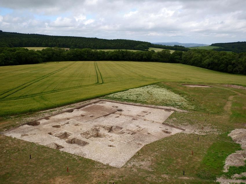
The site of the first year training course at Downley, Singleton, West Sussex. Drone photograph
taken at the end of June 2017, looking north.
Course co-ordinator and lecturer: Mark Roberts (Tutor for Fieldwork)
mark.roberts@ucl.ac.uk
Rm 307. 0207 679 7535.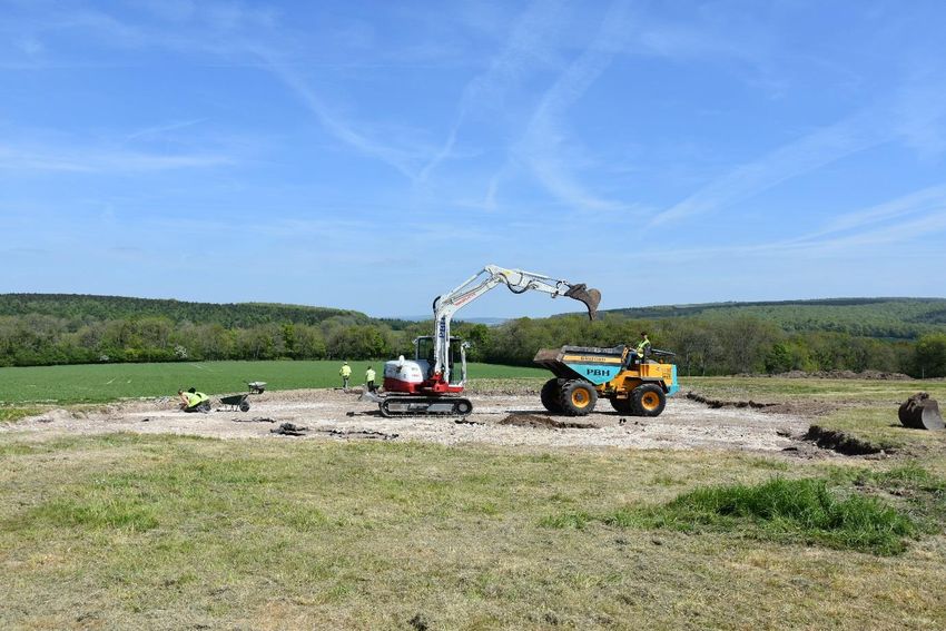
Synopsis

This document is available on-line at:-

http://www.ucl.ac.uk/archaeology/studying/undergraduate/courses/coursehandbooks/ARCL1015
and on the course Moodle page.

Turnitin Code: 3545202

Year password: IoA1718

Lectures:       Term 2. Student Central, Malet Suite 2nd floor. Tuesdays 11.00-12.00.

Practicals:     Term 2. Room 412 at the Institute. Thursdays 10.00-13.00. The practicals/tutorials
                run on alternate weeks throughout Term 2. The class has been subdivided into eight
                groups four of whom attend for one week with the remaining four coming the following
                week.

Archive Course
                This part of the course will run during the Term 2 Reading Week. The year group will
                visit the London Archaeological Archive Centre on one day of the week beginning
                February 12th, after a tour of the centre and lecture you will take away a work package
                that has to be completed and written up in your green books. The course begins at
                10.00 at Mortimer Wheeler House.

The Summer Field Course
                This course will be based at West Dean and runs from the 7th of May until the 29th of
                June for student supervisors, and from the 13th May until the 22nd of June for first year
                students. The year group has been subdivided into five sub-groups, each of whom will
                be on the course for a fortnight. The dates are as follows:- Group 1 May 13th – May
                25th, Group 2 May 20th – June 1st, Group 3 May 27th – June 8th, Group 4 June 3rd – Jun
                15th, Group 5 June 10th – 22nd.

M.B. Roberts December 2017

                                                   2
Overview
ARCL 1015 comprises an introduction to archaeological field methods and techniques taught by
lectures, small group practical classes and fieldwork. All of the teaching takes place in the latter two
terms of the academic year, and is supported by an archive course in the Reading Week of Term 2 and
a two-week field training course during May/June 2018.
Course composition
The distribution of learning hours is as follows: lectures 10 hours; practicals 6 hours;
laboratory/museum work 8 hours; private study and reading 35 hours; fieldwork 90 hours; written work
40 hours
Course contents and delivery
Topics covered will include: locating archaeological sites; methods of archaeological survey; planning
and costing field projects and excavation; excavating archaeological sites – general principles;
excavating archaeological sites – specific techniques; recording archaeological sites; dating and
sampling archaeological sites; post-fieldwork planning post-excavation analysis and research and the
publication of fieldwork reports. Taught through lectures, smaller group practical classes and a
fieldwork training course. The teaching will take place in the second term and culminate in a two-week
field training course in Sussex during May / June, where students will undertake a broad range of the
archaeological excavation, recording and survey techniques previously discussed in lectures. In the
Reading Week of Term 2 all students attend a one day demonstration and practical at the London
Archaeological Archive Centre (LAARC).
Course aims
The aims of this course are to provide students with a broad understanding of archaeological field
techniques and methods: it highlights the aims and limitations of these techniques and demonstrates
their use in a variety of different archaeological scenarios. The course will provide taught and practical
training in desk-top and field survey techniques; excavation; the uses and application of paper and
electronic resources, including archival material, together with mapping and GIS data. . Students are
also taught about the implications and responsibilities arising from invasive excavation techniques, and
the necessity for the publication and dissemination of the ensuing results. The taught course and field
course are thoroughly interlinked, in order to provide students with a working example of
research-led teaching.
3Intended learning outcomes
1. To give the students the degree of competency and confidence to enable them to participate in
fieldwork, across the globe, and in any time period.
2. To raise awareness of the methodological issues surrounding archaeological survey and fieldwork.
3. To critically consider the process of designing and managing a project from initial survey to the
final publication.
4. Develop the student’s group working skills.
5. Expand and improve basic observation and recording skills.
6. Emphasise and develop the many transferable and key skills that are implicit in the execution of
fieldwork and its subsequent, analysis and publication stages.
Application of the learning outcomes
Subject knowledge, understanding and skills. To:-
a) demonstrate a good understanding of the principles and methods by which archaeological
data are acquired and analysed.
b) demonstrate a range of practical experience of the recovery of primary archaeological data
and associated post-excavation methods.
c) show an awareness of the issues involved in planning, designing, and executing a programme
of field, laboratory or museum-based study.
Generic skills. To:-
a) work as a participant or leader of a team, contributing effectively to decision making and the
achievement of objectives.
b) demonstrate visual skills in recognising and describing material remains, and recognising
anomalies.
c) understand the importance of health and safety in the work environment.
Lectures
Lecture 1: 9/1/18. Archaeological Field Methods: an introduction.
Lecture 2: 16/1/18. Locating archaeological sites.
4Lecture 3: 23/1/18. Methods of archaeological survey.
Lecture 4: 30/1/18. Excavating archaeological sites – general principles.
Lecture 5: 6/2/18. Recording archaeological sites.
READING WEEK 12-16th FEB Group visit the LAARC, day to be confirmed.
Lecture 6: 20/2/18. Commercial archaeology.
Lecture 7: 27/2/18. .The River Thames: intertidal and foreshore archaeology.
Lecture 8: 6/3/18. Stratigraphy and the Harris Matrix
Lecture 9: 13/3/18. . Dating and sampling archaeological sites.
Lecture 10: 20/3/18. Post-fieldwork planning, post-excavation analysis and research and the
publication of fieldwork reports.
Practicals/tutorials
Practical 1: 11/1/18. Map reading.
Practical 1: 18/1/18. Map reading
Practical 2: 25/1/18. Working with on-line resources: HERs, the Archaeology Data Service & EH’s
Pastscape.
Practical 2: 1/2/18. Working with on-line resources: HERs, the Archaeology Data Service & EH’s
Pastscape.
Practical 3: 8/2/18. Working with aerial photographs.
READING WEEK 12-16th February - group visit to the LAARC, day to be confirmed.
Practical 3: 22/2/18. Working with aerial photographs.
Practical 4: 1/3/18. Visit to Thames foreshore, with the TDP. (All the year).
Practical 5: 8/3/18. Stratigraphy, context recording and the Harris Matrix.
Practical 5: 15/3/18. Stratigraphy, context recording and the Harris Matrix.
Practical 6: 22/3/18. Tutorial, revision, essay assignment and the forthcoming field course (All the
year).
5Practical/Tutorial Groups
Practicals/tutorials are held in Room 412 at the Institute.
Practical Group 1 Thursday 10.00 - 11.00. Alternate weeks on January 11th, 25th, February 8th,
March 1st, 8th, 22nd.
Sacha Cummins, Sophia Robinson, Alexander Salikan, Lydia Bramley, Rachel Rudkin,
Caitlin Nathan-Maister, Finn Stileman, Katherine Bettis.
Practical Group 2 Thursday 11.00 - 12.00. Alternate weeks on January 11th, 25th, February 8th,
March 1st, 8th, 22nd.
Shu Wai Chung, Raffaele Bellino, Emmy Davies, Hannah Gibbs, Tonia Lawes, Huan Qu, Lan Shi,
Veena Jayanth, Yick Ching Lee, Fabio Spalla, Shunzi Zhang.
Practical Group 3 Thursday 12.00 - 13.00. Alternate weeks on January 11th, 25th, February 8th,
March 1st, 8th, 22nd.
Yixuan Peng, Georgina Harris, Louise Brochard-Lebrun, Nurul Hamizah Binti Afandi, Maksymilian
Debrowski, Claudia Harrington, Min Seo Jung, Flora Peychere, Sam Stewart, Louise Prior.
Practical Group 4 Thursday 09.00 - 10.00. Alternate weeks on January 18th, February 1st, 22nd,
March 1st, 15th, 22nd.
Samuel Atkins, Talia Cohen, David Faddoul, Darcy Inchboard, Caragh Murphy-Collinson, Isabelle
Willcocks, Ines de Larrinaga, Molly Vowles, Fahmida Begum.
Practical Group 5 Thursday 10.00 - 11.00. Alternate weeks on January 18th, February 1st, 22nd,
March 1st, 15th, 22nd.
Ines Fernandez-Pontes, Eve Drysdale, Liv Estrup Udsen, Lan Jin, Loren McGrave, Yin Man Chan,
Christopher Green, Lily Carter, Mimaansa Ghildiyal, Jakov Mlinarevic.
Practical Group 6 Thursday 11.00 - 12.00. Alternate weeks on January 18th, February 1st, 22nd,
March 1st, 15th, 22nd.
Karna Reinmoeller, Sovanna Carnell Guyon, Tarsha Coleman, Max Currer, Han Jung Jae, Adrien
Benabou, Beca Davies, Eugenia Pacheco Aisa, Katerina Theodoraki.
Methods of assessment
A 2000 word essay (from a choice of three). 40% Hand in 23/4/18
1/. Knowing what you have been taught and learnt about Downley, outline the procedure you would
follow for producing a proposal for the future excavation of the nearby deer park and lodge at East Dean
Park, West Sussex, also part of the Honor of Arundel and a possession of the Earl. Specify the types
of data you need to gather to inform your report, and their sources. Describe who you would need to
collaborate with to achieve your goal.
62/. Having attended lectures that have drawn heavily on the 2014-2017 excavations at Downley, along
with reading the published interim report (Roberts 2014) and preliminary post-excavation reports posted
on Moodle, construct a project design for the 2018 excavations at the site. You will need to outline and
justify your plans and explain how you will implement them with the resources at your disposal.
Finally, you will consider the post-excavation planning required, given the scale of the project you are
going to undertake and what you are likely to find.
3/. You have been asked to direct the write-up of a lapsed project that involved the excavation of a
Roman cemetery site, inland from the banks of the River Thames, in the 1980s. Outline the team you
will put together and their specialist areas of research. Describe the type of archive and finds your team
will be working with and how you will integrate the archive and the finds. Outline your liaison
procedure with the LAARC for storage of the finds and the archive.
Two practical assignments. 30% Hand-in 2nd* & 16th#/3/18 & 23/4/18
The assignments are given out during the practical/tutorial classes and then go up on Moodle for the
whole class to see and draw down the accompanying information electronically.
*Practical groups 1-3, # Practical groups 4-6.
Marking of the Field notebook. 30% Late May and June 2018
Your notes taken at the LAARC and during the field course at Downley are assessed and marked.
Attendance
A register will be taken at each class. If you are unable to attend a class, please notify the lecturer by
email. Departments are required to report each student’s attendance to UCL Registry at frequent
intervals throughout each term. Students are expected to attend at least 70% of classes.
Information for intercollegiate and interdepartmental students
Students enrolled in Departments outside the Institute should collect hard copy of the Institute’s
coursework guidelines from Judy Medrington’s office (411A).
Dyslexia
If you have dyslexia or any other disability, please make your Course Co-ordinators aware of this fact
and discuss with them whether there is any way in which they can help you. Students with dyslexia are
reminded to indicate this on each piece of coursework.
7Feedback
In trying to make this course as effective as possible, we welcome feedback from students during the
course of the year. All students are asked to give their views on the course in an anonymous
questionnaire which will be circulated at one of the last sessions of the course. These questionnaires
are taken seriously and help the co-ordinator to develop the course. The summarised responses are
considered by the Institute's Staff-Student Consultative Committee, Teaching Committee, and by the
Faculty Teaching Committee.
If students are concerned about any aspect of this course we hope they will feel able to talk to the Course
Co-ordinator, but if they feel this approach is not appropriate, they should consult their Personal Tutor,
the Academic Administrator (Judy Medrington), or the Chair of Teaching Committee.
Health and safety
The Institute has a Health and Safety policy and code of practice which provides guidance on field
work, site visits, laboratory work etc. This policy is revised annually and the new edition will be issued
in due course. All work undertaken in the Institute is governed by these guidelines, and students have
a duty to be aware of them and to adhere to them at all times. This is particularly important in the
context of the laboratory/field/placement work which will be undertaken as part of this course. Specific
information pertaining to activities associated with this course shall be given prior to their undertaking.
Written and pro forma risk assessments are prepared for the field course and field trips and lodged with
Sandra Bond at the Institute.
Lecture 1. 9/1/18. Archaeological field methods: an introduction.
The lecture runs through all the topics to be covered in the course and constitutes an informal
introduction to its contents and aims. The lecture also covers the structure of the course in terms of the
practical work to be undertaken on Thursdays, together with the required coursework, submissions dates
and procedures. The lecture and all subsequent lectures are made available on-line. In this course,
especial emphasis is placed on research-led teaching, this means applying the methods and techniques
taught in the course back to the specific object of this year’s Field Course, the excavation and survey
of the “lost” deer park and lodge at the site of Downley, Singleton, West Sussex, and the preparation
for the continuation of a new project, begun in 2017, researching the forest and lodge at Lamb Lea 5km
to the east. Many of the maps, photographs and digital terrain models (DTMs) are available via the
Powerpoint presentation for this lecture.
8Principal texts
The principal texts are Renfrew and Bahn (2008) and Carver (2009), multiple copies of which are
available in the library. There are various other texts on archaeological field methods including
Drewett’s textbook (1999) and his seminal work on Bullock Down (1982); Barker (1993), and that by
McIntosh (1986). The Downley interim report is available in Archaeology International (Roberts 2014)
and in a more detailed format on the Moodle site.
Barker, P.A. 1993. Techniques of Archaeological Excavation. London: Batsford (3rd
Edition). ISSE DESK INST ARCH AL BAR & INST ARCH AL BAR.
Carver, M. 2009. Archaeological Investigation. London: Routledge. ISSUE DESK IOA CAR 6 &
INST ARCH AL 10 CAR 6.
Drewett, P.L. 1982. The Archaeology of Bullock Down, Eastbourne, East Sussex. The development of
a landscape. Lewes: Sussex Archaeological Society. ISSUE DESK INST ARCH DRE & INST ARCH
DAA 410 S.10 DRE.
Drewett, P.L. 2011. Field Archaeology: an introduction. (2nd Edition) Oxford: Routledge. ISSUE
DESK IOA DRE 2 & INST ARCH AL 10 DRE.
McIntosh, J. 1999. The practical archaeologist: how we know what we know about the past. London:
Thames and Hudson. 2nd revised edition. INST ARCH AH MCI.
Morrison, W., Thomas, R. and Gosden, C. (2014). Laying Bare the Landscape: commercial archaeology
and the potential of digital spatial data. Internet Archaeology. http://dx.doi.org/10.11141/ia.36.9
Renfrew, C. and Bahn, P. 2008. Archaeology, Theories, Methods, and Practice. London: Thames and
Hudson. (5th edition). ISSUE DESK INST ARCH AH REN & INST ARCH AH REN.
Roberts, M.B. 2014. The Institute of Archaeology Field Course 2014: the search for the lost
hunting lodge of the Earls of Arundel at Downley, Singleton, West Sussex, UK. Archaeology
International
9Practical 1. 11 & 18/1/18. Maps and map reading.
Orientating the map.
In the field you must know how to orientate the map so that you can relate features on the map to the
physical features around you. To do this you will need a magnetic compass, which you line up with
Eastings lines. The top of the map is always orientated to the North. See the OS guide which outlines
the three types of north.
The scale of the map.
There are many different map scales: essentially, the larger the number the larger the amount of ground
covered. Compare the 1:25,000 and 1:10,000 examples you have been given. 1:25,000 means that 1cm
on the map equals 25,000 on the ground or 1cm = 250m; 1:10,000 means that 1cm on the map equals
10,000 on the ground or 1cm = 100m.
Locating your OS identifier square.
Great Britain is divided up by the Ordnance Survey into 100km2 blocks each of which is given a unique
two letter code e.g. TQ, SU. You must always use these prior to giving your grid reference. You can
find these letters on the map you have been given. Each 100km2 also has two identifier numbers for
example SU is 41, 400km to the east and 100km to the north (see handout).
Eastings and Northings.
Read the Easting first; these are the numbers along the bottom of the map that increase eastwards, and
then the Northing; these are the numbers along the side of the map which increase northwards.
Finding places and features.
You will be given a grid reference and told to find a place, and then you will be given a place and told
to provide a grid reference.
How contours work.
The contour lines on your map indicate the height of the ground above sea level AOD (above Ordnance
Datum). The lines join up spots of identical height. The further the lines are apart the gentler the relief,
the closer together the steeper the relief.
Other types of map used by archaeologists.
Archaeologists use many other different types of map, including geological and marine maps. We shall
have an attempt at using a geological map.
Ordnance Survey. 2013. Map Reading: from the beginner to the advanced map reader.
Available on-line at www.ordnance.survey.co.uk or from the Moodle site.
Lecture 2. 16/1/18. Locating archaeological sites
Archaeological sites are to be found both beneath our feet and all around us. Many sites are extant and
visible in the modern landscape: some continue their original function into the present day, whereas
others might now be used for a purpose unintended and unimagined by their constructors. There are
also sites whose landscape setting has completely changed due to a combination of topographic and
environmental change; these might be now buried by substantial depths of sediment or perhaps been
overtaken by marine transgression.
10It is axiomatic that sites and landscapes are preserved in many differing states dependent upon the
taphonomic processes operating over time; in addition to natural taphonomic processes, the actions of
successive generations of humans in the landscape must also be considered. Archaeologists have to be
able to recognise and interpret sites at these many preservation levels. Similarly, project planning, the
type and scale of interventions, survey and sampling, will all be facilitated by understanding the
landscape type and history, together with the past and present physical and biological processes and
conditions that could affect a site and its associated archaeological material.
In any given area, past find spots and sites are contained within the Historic Environment Record of
local authorities, these records are in some instances further supported by data held by the national
statutory bodies such as Historic England, the Royal Commission, the National Archives, etc. From
these organisations the prospective excavator can gain access to scheduling data, maps and plans, a
description of the site types mentioned, and a bibliography of past investigation history. More mapping
information is available through Edina Digimap, where it is possible to view and download maps and
map data, including different scale Ordnance Survey (OS) maps, old versions of maps, geological and
marine maps.
Aerial photography constitutes one of the key tools in the identification of archaeological sites. The
principles behind its methods and applications are given in your key texts and in more detail below.
Key elements that reveal sites are crop marks, shadow marks, and parch marks but there are many
further nuances of these main categories which are shown in the lecture. Today the technology also
exists to see sites and topography where the ground surface is covered by woodland; this technique is
known as LiDAR (Light Detection and Ranging) and has been used to locate archaeological sites, with
great success, in both Britain and other parts of the world. We shall look at the recent Lidar project
undertaken in the area of our fieldwork – “The secrets of the High Woods Project”. On a larger scale
remote sensing from satellites has produced detailed LANDSAT images that are of immense use to
archaeologists working on a landscape and regional scale, especially in otherwise inaccessible areas.
Clark, J., Darlington J. and Fairclough, G. 2004. Using Historic Landscape Characterisation. English
Heritage. Download at http://www.english-heritage.org.uk/publications/using-historic-landscape-
characterisation/using-historic-landscape-characterisation2004.pdf
English Heritage 2007. Understanding the Archaeology of Landscapes: a Guide to Good Recording
Practices. Download at http://www.english-heritage.org.uk/publications/understanding-archaeology-
of-landscapes/understandingthearchaeologyoflandscapespart1pp1-9.pdf
Fairclough G. 2005. Boundless Horizons: Historic Landscape Characterization. English Heritage.
Download at http://www.english-heritage.org.uk/publications/boundless-horizons-historic-landscape-
characterisation/boudlesshorizons.pdf
Riley, D.N. 1987. Air Photography and Archaeology. London: Duckworth. INST ARCH AL 21 QTO
RIL.
11Riley, D.N. 1996. Aerial Archaeology in Britain. Princes Risborough: Shire. ISSUE DESK INST
ARCH AL 21 RIL.
Scollar, I., Tabbagh, A., Hesse, A. and Herzog, I. 1990. Archaeological Prospecting and Remote
Sensing. Cambridge: CUP. (Latest edition CUP 2009).
South Downs National Park Authority (SDNP), 2016. Secrets of the High Woods Project.
http://www.southdowns.gov.uk/secretsofthehighwoods
Tilley, C. 2004. Round Barrows and Dykes as landscape Metaphors. Cambridge Archaeological
Journal. 14 (2), 185-203.
Tilley, C. 2010. Interpreting landscapes: geologies, topographies, identities. Walnut Creek CA:
Left Coast Press.
Wilson, D.R. 1975. Aerial reconnaissance for archaeology. London: CBA Research Report 12. INST
ARCH DAA QTO SERIES COU 12. Also available through the on-line reading list.
Wilson, D.R. 1982. Air Photo Interpretation for Archaeologists. London: Batsford. ISSUE DESK
INST ARCH WIL 12; see also 3rd edition by Tempus Publishing. INST ARCH AL21 WIL.
Lecture 3. 23/1/18. Methods of archaeological survey.
Having identified a site/landscape for investigation from the Historic Environment Record (HER)
and/or by means of aerial analyses, the archaeologist’s attention now turns to on the ground field
surveys. An effective method of physically covering large areas of terrain, especially under tree cover,
is to undertake a landscape survey, using a line of people to record potential archaeological features.
The exercise is normally undertaken in a series of transects, whereby the line stops each time a feature
is observed, its characteristics are recorded and a grid reference taken using a hand-held GPS. During
the 2009 field course, the students located one of the best examples of a downland burnt mound in
Southern England using this method of survey. An example sheet is given in the appendices at the end
of the handbook. Once a site or site complex has been discovered, other non-invasive methods of
investigation can be employed. In essence these methods produce data that is converted into a visual
image: thus, informing the archaeologist of the type and nature of structures buried at the site. These
methods are used to locate sites within an archaeological landscape or to provide detail on specific areas
within sites; for example, a considerable amount of investigation and analysis has been applied to the
interior of Iron Age hillforts (see English Heritage 2008 below). The main methods considered in the
lecture are resistivity, magnetometry and ground penetrating radar. In the first instance you should gain
a general working knowledge of the techniques and the suitability of their application by reading the
appropriate sections in Renfrew and Bahn, and Carver, and then expand your reading by choosing
something from the list below. In terms of the fieldwork we are going to carry out, the Historic England
(English Heritage) 2008 publication is excellent.
12Clark, A. 1996. Seeing Beneath the Soil: Prospecting Methods in Archaeology. London: Batsford.
ISSUE DESK INST ARCH AL 13 CLA.
David, A. 1995. Geophysical Survey in Archaeological Field Evaluation. London: English Heritage.
INST ARCH AL 12 QTO DAV & available through the on-line reading list.
Drewett, P.L. 1982. The Archaeology of Bullock Down, Eastbourne, East Sussex. The Development of
a Landscape. Lewes: Sussex Archaeological Society. (p. 99). ISSUE DESK INST ARCH DRE and
INST ARCH DAA 410 S 10 DRE.
*English Heritage. 2008. Geophysical Survey in Archaeological Field Evaluation. Swindon: English
Heritage. This is the updated version of David, A. 1995 given above, and is available on line with free
download at:
http://www.english-heritage.org/upload/pdf/GeophysicsGuidlines.pdf
*Gaffeny, C. And Gator, J. 2003. Revealing the Buried Past. Geophysics for Archaeologists. Stroud:
Tempus. INST ARCH AL 12 GAF. (The best introduction to modern archaeological geophysics).
Gaffeny, C., Gator, J. and Ovenden S. 2002. The use of Geophysical Techniques in Archaeological
Field Evaluations. IFA Paper No. 6. Reading: Institute of Field Archaeologists. (Quite a thin
pamphlet.).
Johnson, J.K. (ed.) 2006. Remote sensing in archaeology: an explicitly North American perspective.
Tuscaloosa: University of Alabama Press. I NST ARCH AL 13 JOH. (Excellent and very useful book,
and not just for North America.)
Use also Renfrew and Bahn (pp.95-106) and Carver (pp.89-112) from the main reading list.
If you would like to follow up this topic have a look at the journal Archaeological Prospection.
Available online from volume 54, number 1.
Practical 2: 25/1/18 & 1/2/18. Working with on-line resources: Historic Environment Records
(HERs), British History On-Line, the National Archives, the Archaeology Data Service & HE’s
Pastscape.
The internet has made a wide range of resources available to archaeologists; as little as twenty
years ago the amount of data you can collect and store in an hour would have taken months to
find, study and copy. Today’s practical will begin with us creating a Downley File, with three
sub-folders, Texts, Maps and Figures, into which you will begin to put material from the
lectures and practicals. We shall look for the Downley site in a conventional Google search;
you will learn how to refine your search using other parameters, such as county suffixes and
other relevant identifiers, paying attention to the caveat that there are many variations in place
names both at the time and through time. We shall then look for information on Downley from
historical records and the main archaeological data bases, and see how information is linked
through bodies such as The Archaeology Data Service and English Heritage. You will be asked
to locate the data pertaining to the Downley site and link this to other tools such as Google
13Earth and Edina Digimap. Part of your fortnightly course work will be to download the SU81
25k tile from Edina and crop it to include the deer park perimeter. You will also have to find
some correspondence dating from the reign of Henry VIII that pertains to or was sent from
Downley. Finally, you should search some other field relevant to Downley (i.e. Medieval
hunting with dogs) and capture some relevant images for your folder.
Lecture 4: 30/1/18. Excavating archaeological sites – general principles.
Excavation of archaeological sites is conducted at various scales that are dependent on factors such as:
the size of the archaeological feature(s) under investigation; the time allowed to carry out the work,
time can be determined by contractual parameters or physical restraints such as daylight etc.; the budget
available for the works; the fieldwork methods chosen to effect the aims of the research design and
many other factors, some which might be anticipated and others that might be unanticipated.
Preliminary physical investigation might take the form of test pits, and auger or boreholes depending
on the depth of stratigraphy; within these individual categories the rigour and precision of execution
and recording may vary according to constraints. Having established a case for excavation there are
many different techniques and methods that can be employed to achieve the final objective. In many
cases today, full or complete excavation of a site or landscape is not possible and in these cases the
intervention will constitute a sample, normally defined in square metres, of the complete area. In
addition to the factors mentioned above, the excavation of a site will also be dictated by the physical
nature of the site, which includes varied factors e.g. sedimentology; depth of deposits; survivability of
standing structures like banks, walls or barrow mounds; deep structures such as wells and ritual shafts;
the presence of groundwater and waterlogging; presence and preservation of associated
palaeoenvironmental remains; and many more. Specific techniques have been developed to cope with
all these factors and this lecture will examine a sample of them. In preparation for next week’s talk we
will examine the relationship between excavation and recording and how the streamlining of these
processes will aid the writing –up and dissemination of the data generated by excavation. The lecture
will also look at the integration of excavation and land restoration during the course of a project, this is
especially germane on many big commercial projects where the site might be incorporated into the
finished structure, in the case of some buildings or where the design of a project is altered and the site
is largely preserved beneath a structure.
English Heritage. 1991. Management of Archaeological Projects (MAP 2). London: English
Heritage. INST ARCH DAA 100 ENS. Available through the on-line reading list.
English Heritage. 2006. Management of Research Projects in the Historic Environment: the MoRPHE
Project Managers’ Guide. Swindon: English Heritage.
14English Heritage. 2008. MoRPHE Technical Guide 2 Project Inception and Project Governance for
the Governance for the English Heritage Research Department. http://www.english-
heritage.org.uk/publications/morphe-technical-guide-2/intmorphetechnicalguide2.pdf
English Heritage. 2008. SHAPE 2008: a strategic framework for historic environment activities and
programmes in English Heritage. London; English Heritage.
English Heritage. 2008. MoRPHE PPN 3: Archaeological Excavation. Swindon: English Heritage.
The articles given above concern the procedure and standards required for archaeological project
management and strategy by the statutory body English Heritage. Have a look at summaries of these
on-line as they will give you a background to this particular facet of archaeological techniques and
methods.
Baker, D. 1993. Model Briefs and Specifications for Archaeological Assessments and Field
Evaluations. Association of County Archaeological Officers. I NST ARCH AL 10 ASS.
Barker, P.A. 1993. Techniques of Archaeological Excavation. London: Batsford (3rd
Edition). ISSUE DESK INST ARCH AL BAR & INST ARCH AL BAR.
Collis, J. 2001. Digging up the Past. Stroud: Sutton. (Chapter 2). ISSUE DESK IOA COL 8 & INST
ARCH AL 11 COL. Also available through the on-line reading list.
Drewett, P.L. 1999. Field Archaeology: an Introduction. London: UCL Press. (Chapters 5 and 6).
ISSUE DESK IOA DRE 2 & INST ARCH AL 10 DRE.
Greene, K. 2002. Archaeology, an Introduction. London: Batsford. (Chapter 3). (4th Edition). INST
ARCH AL GRE. Also available through the on-line reading list.
Roskams, S. 2001. Excavation. Cambridge: Cambridge University Press.
Westman, A. (ed.) 1994. Archaeological Site Manual. London: Museum of London. ISSUE DESK
INST ARCH AL WES & INST ARCH AL WES. Also available through the on-line reading list and as
a free download.
Lecture 5: 6/2/18. Recording archaeological sites.
The course has covered the location and non–invasive recording of archaeological landscapes, through
the media of desk-based surveys, field surveys, metal detecting, geophysics and aerial photography, in
earlier lectures. Having also considered the physical aspects of excavation we now come to recording
what we excavate. The bottom line of recording is to use the best practices and equipment available to
us, to effect the virtual reconstruction of both the site and the excavation. There will always be
constraints placed upon recording as there are on excavation but the archaeologists should do their best
to obviate them or work with them. If it is considered that the constraints are such that the site cannot
be adequately recorded then excavation should not take place.
In the field there are three main types of record: the written record; the drawn record and the
photographic record. Within these broad categories sit numerous sub-categories such as context sheets
and bulk recording sheets; plans and sections; and film and digital photographs. The recording of the
15site is an integral part of the excavation process and is a key facilitator in the post-excavation process;
the quality of the records kept will determine the quality of the post-excavation methodology and
analysis, and ultimately the publication of the work.
Most sites across the world now employ the system of single context recording system although you
should still be cognisant of other methods such as Area/Feature/Layer. The single context system can
be illustrated during and after excavation by the construction of Harris matrices which can be used to
illustrate the chronological relationship of the excavated contexts. Further work on Harris matrices will
be undertaken in the next set of practicals. The key to success in recording excavations is to keep
detailed records; these might then be additionally supported by the use of site notebooks and an informal
photographic record. The database produce should be fully integrated so that context sheets link up to
feature sheets, specialist recording sheets, drawings and photographs. The records should also include
details of other activities such as metal detecting of spoil heaps, geophysics carried out on areas of the
excavation, samples taken for dating etc.
When considering the recording methodology to be used on site, the archaeologist must also consider
how the data will be used off-site; for example how do the records lend themselves to construction of
computerised data bases? Does the system lend itself to effective comparison with other databases? It
is vital that these sorts of questions are weighed and solved before excavation begins but the responses
and methods must also be flexible enough to allow for manipulation and change during the excavation
stage.
Barham, A.J. and Macphail, R.I. (eds.) 1995. Archaeological Sediments and Soils: Analysis,
Interpretation and Management. London: Institute of Archaeology. ISSUE DESK INST ARCH BA
23 BAR & INSTARCH BA 23 BAR.
Barker, P.A. 1993. Techniques of Archaeological Excavation. London: Batsford (3rd
Edition). ISSUE DESK INST ARCH AL BAR & INST ARCH AL BAR.
Bettess, F., 1998. Surveying for Archaeologists. Durham: University of Durham. [ARCH AL 12 BET;
TEACHING COLLN ARCH 2518]
Courty, M.A., Goldberg, P.A. and Macphail R.I. 1989. Soils and Micromorphology in Archaeology.
Manuals in Archaeology. Cambridge: Cambridge University Press. ISSUE DESK INST ARCH COU.
Drewett, P.L. 1982. The Archaeology of Bullock Down, Eastbourne, East Sussex. The development of
a landscape. Lewes: Sussex Archaeological Society. Various relevant pages but look at 9–12 and the
Roman farmstead excavation 97–142. ISSUE DESK INST ARCH DRE & INST ARCH DAA 410
S.10 DRE. Available through the on-line reading list.
Harris, E.C. 1975. The stratigraphic sequence: a question of time. World Archaeology. 7: 109–121.
INST ARCH PERS. Available through the on-line reading list.
Harris, E.C. 1977. Units of archaeological stratification. Norwegian Archaeological
16Review. 10: 84–94. INST ARCH PERS
Harris, E.C. 1989. Principles of Archaeological Stratigraphy. (2nd edition). London: Academic Press.
(See especially chapters 7, 8, 9 and 11, although this is quite a short book and fundamental). INST
ARCH AL HAR (028). Now available as a PDF file http://www.harrismatrix.com/
Harris, E.C., Brown M.R. and Brown G.J. (eds.) 1993. Practices of Archaeological Stratigraphy.
Academic Press: London. INST ARCH AL HAR.
Renfrew, C. and Bahn, P. 2008. Archaeology, Theories, Methods and Practice. (5th edition) . London:
Thames and Hudson. Pages 107–117. INST ARCH AH REN.
Roskams, S. (ed.) 2000. Interpreting Stratigraphy: site evaluation, recording procedures
and stratigraphic analysis: papers presented to the Interpreting Stratigraphy Conferences 1993–1997.
Oxford: British Archaeological Reports International Series 910.
INST ARCH AL 10 QTO ROS.
Westman, A. (ed.) 1994. Archaeological Site Manual. London: Museum of London. ISSUE DESK
INST ARCH AL WES & INST ARCH AL WES. Also available through the on-line reading list and as
a free download.
Wheeler, R.E.M. 1954. Archaeology from the Earth. Oxford: Oxford University Press. (Especially
chapter 4). INST ARCH AL WHE.
Practical 3: 8 & 22/2/18. Working with aerial photographs.
See the reading list for Lecture 2 above. You can download the aerial photographs and the maps used
in the class practical (SU91) from the Moodle site.
In this class we are going to combine the information given in the first set of lectures, with some
practical examples of studying aerial photographs and combining them with information given on the
OS map. The photographs of the Heyshott Down Barrow Group were taken six years apart, see what
has changed in the time between the two images, you should also look for clues as to what time of year
they were taken and how the archaeological monuments appear in each. Taking these images, and the
one showing a range of archaeological sites from a location to the east, you then need to locate them on
the OS map; use the hints and guides we discussed in Practical 1 to work out where the images are on
the map. The third photograph is accompanied by a Digital Terrain Model (DTM) made by the students
on the 201 surveying course, using this model in conjunction with the aerial photograph, locate their
site on the map (SU81) and describe the class of monument they were surveying. At the end of the
class you will be given Assignment 1. Groups 1-3 hand in on the 9th march and groups 4-6 on the 16th.
Lecture 6: 20/2/18. Commercial archaeology.
Developer Funded Archaeology comprises the largest single source of field work and excavations in
Britain today. Archaeological assessments, both desk-based and physical, watching briefs, and full
17scale excavation mitigation are now integrated into the planning and development framework. Under
the recent, 2012, National Planning Policy Framework (NPFF), an easing of planning restrictions has
been thought by the archaeological profession to be potentially deleterious to the buried archaeological
record, although this fear has yet to be realised. The lecture covers the range of work covered by
commercial archaeologists and discusses the pros and cons of the developer funded system. The
implications for assess to archaeological excavations for amateurs and students and the re-emergence
of the local society as sources of fieldwork are examined.
Rather than adding a reading list here, I have attached some relevant articles on the Moodle site, some
of which contain interesting further reading. The Current Archaeology article is a good place to start
as it covers a wide range of opinion across many sectors, at the beginning of the Millennium. My own
general list of pros and cons is available from the Powerpoint slides. The three web sites below give a
good example of the potential of liaison between the sectors to produce high quality research and the
effect of developer funding on the availability of places on excavations.
http://www.cotswoldarchaeology.co.uk/developer-funded-roman-archaeology-in-england
http://www.archaeologyuk.org/participation/recommendations/non-developer
https://www.ucl.ac.uk/archaeologyse
Lecture 7: 27/2/18. Stratigraphy and the Harris Matrix.
This session builds on the introduction given in Lecture 5 and looks at the laws/rules pertaining to the
elucidating of geological and archaeological stratigraphy and, specifically, the Law of Superposition.
The lecture will go on to examine two different recording systems: the feature/layer method and single
context recording. From the single context system we shall look at the powerful tool that is the Harris
Matrix and study some specific examples using this method. The lecture will also address the
description of archaeological sections, looking at key features and the descriptive terms utilised to
describe them.
In addition to the references for Lecture 5 you should also try and look at:-
Hodgson, J.M. 1976. Soil Survey Field Handbook. Soil Survey Technical Monograph 5. Hapenden:
Soil Survey.
Jones, A.P., Tucker, M.E. and Hart, J.K (eds.). 1999. The description and analysis of Quaternary
stratigraphic field sections. QRA Technical Guide No. 7. London: Quaternary Research Association.
Trudgill, S. 1989. Soil Types: a Field Identification Guide. Field Studies Council, AIDGAP Guide
196.
Tucker, M.E. 1996. Sedimentary rocks in the field (2nd edition). Chichester: Wiley.
The MoLAS excavation manual available from the Moodle page and referenced in Lecture 6 under its
editor A. Westman.
18[Practical 4 is the visit to the Thames foreshore on March 1st 2018
The River Thames cuts a long geological and archaeological section through London and its environs.
The sediments of the Thames contain a vast repository of archaeological material ranging from
Palaeolithic flintwork and Pleistocene fauna, through Bronze Age fish traps and votive offerings, to the
Medieval and modern development of the capital city of a growing maritime state and its empire.
A visit to the river with experts from the Thames Discovery Programme brings the archaeology to life
and will enable you to understand the complexity of multi-layered stratigraphy and virtually continual
occupation over a millennial time scale.
Please see the Moodle site, nearer to the date of the trip, for more information.]
Practical 5: 8 & 15/3/18. Stratigraphy, context recording and the Harris Matrix.
This practical builds on what you have learnt in Lecture 7 and involves the classes working through
some examples of archaeological section drawings and photographs in order to establish a stratigraphic
description of the sections and discuss the context numbering system which the excavators employed.
We shall then look at a hypothetical Harris Matrix, details of which are downloadable from the Moodle
site. The pdf of Ed Harris’s seminal work is available on the Moodle site for reading and download.
At the conclusion of the class you will be given your second assignment, which will involve the
description of a section photograph and the construction of a Harris Matrix from archaeological plan
and section drawings.
Lecture 8: 6/3/18. Dating and sampling archaeological sites.
Methods of dating sites is covered by ARCL1014, during the first term, thus in this lecture we shall
concentrate on looking at how we shall go about dating the very different occupation horizons at
Downley and Boxgrove, and also the Bronze Age Burnt Mounds excavated as part of the field course
between 2010 & 2015. Having excavated, recorded and established the stratigraphy at the sites we shall
move on to looking at our sampling strategies; thinking about the rationale behind sampling, constraints
on sampling and the practical application of the various methodologies.
Dobney, K., Hall, A., Kenward, H. and Miles, A., 1992. A working classification of samples types for
environmental archaeology. Circaea 9 (for 1991): 24–26. INST ARCH PERS. Available through the
on-line reading list.
Evans, J. and O’Connor, T 1999. Environmental Archaeology. Stroud: Sutton Publishing. Chapter 8.
INST ARCH BB 6 EVA. Available through the on-line reading list.
Holden, T. and Gerber-Parfitt, S., 1992. Environmental sampling, processing and some preliminary
results from Bull Wharf. London Archaeologist 6: 427-34. INST ARCH PERS; TEACHING COLL.
INST ARCH 118. Available through the on-line reading list.
19Murphy, P. L., and Wiltshire, P. E. J. W. 1994. A guide to sampling archaeological deposits for
environmental analysis. Unpublished manuscript. INST. ARCH. TEACHING COLLECTION 1178.
Available through the on-line reading list.
Westman, A (ed.)., 1994. Archaeological Site Manual. London: Museum of London. Read the section
on Environmental Sampling. INST ARCH AL WES. Available through the on-line reading list.
Lecture 9: 13/3/18. Post-fieldwork planning, post-excavation analyses and research.
This lecture will outline and discuss the important stages of work which must follow any archaeological
fieldwork, i.e., the reporting and analysis of what was undertaken and found. Post-fieldwork planning
is often an overlooked part of the archaeological process both in terms of fiscal and time budgeting,
which in turn has an axiomatic knock-on effect on the ensuing analyses, research and publication. Your
visit to the LAARC will have given you a good idea about the end product of archaeological excavations
and the corollary logistics concerning the storage of the physical, paper and electronic archives. In the
lecture we shall consider what type of planning we need to undertake for our excavations at Downley,
what analyses are likely to be required and how we shall have to structure the research. Although now
replaced, we shall also analyse the Historic England guidelines for this type of work using the MoRPHE
and SHAPE blueprints and also the more specific data given in the relevant MoRPHE Project Planning
Notes.
Andrews, G. 1991. Management of Archaeological Projects (MAP 2). London: English
Heritage. INST ARCH DAA 100 ENS Available through the on-line reading list.
Boulton, P. 1991. Signposts for Archaeological Publication (3rd edition). London: Council for
British Archaeology. ISSUE DESK INST ARCH CoU.
Drewett, P.L. 1982. The Archaeology of Bullock Down, Eastbourne, East Sussex. The development
of a landscape. Lewes: Sussex Archaeological Society. Issue desk: INST ARCH DRE; main
collections: INST ARCH DAA 410 S.10 DRE. This volume is an example of an end product of the
post excavation process.
Drewett, P.L. 1999. Field Archaeology: an Introduction. London: UCL Press, chapter 8. INST
ARCH AL 10 DRE; ISSUE DESK IoA DRE 2.
English Heritage. 2008. SHAPE 2008: a strategic framework for historic environment activities and
programmes in English Heritage. London: English Heritage.
English Heritage. 2013. MoRPHE PPN 6: Writing standards and guidance. Swindon: English
Heritage.
Grinsell, L., Rahtz, P. and Williams, D.P. 1974. The Preparation of Archaeological Reports (2nd
edition). London: Barker. ISSUE DESK INST ARCH GRI
20Historic England. 2015. Management of Research Projects in the Historic Environment: the
MoRPHE Project Managers’ Guide. Swindon: English Heritage.
https://historicengland.org.uk/images-books/publications/morphe-project-managers-guide/
Lecture 10: 20/3/18. The publication of fieldwork reports.
The lecture examines the publication process, in the first instance deciding what the appropriate vehicle
for publication might be, including both conventional and web-based media. We shall look at
submitting a journal article, getting a book proposal accepted, using the internet and grey literature.
The lecture also considers different ways of publishing archaeological fieldwork and considers how
texts, images and pictures shape our perceptions and expectations of the past.
Ancient Monuments Board (DoE). 1975. Principles of Publication in Rescue Archaeology. INST
ARCH AL 30 ANC; ISSUE DESK INST ARCH ANC.
Andrews, G. 1991. Management of Archaeological Projects (MAP 2). London: English Heritage.
INST ARCH DAA 100 ENS Available through the on-line reading list.
Boulton, P. 1991. Signposts for Archaeological Publication (3rd edition). London: Council for
British Archaeology. ISSUE DESK INST ARCH COU.
Council for British Archaeology. 2001. From the ground up: the publication of archaeological projects.
http://www.archaeologyuk.org/publications/puns
Grinsell, L., Rahtz, P. and Williams, D.P. 1974. The Preparation of Archaeological Reports (2nd
edition). London: Barker. ISSUE DESK INST ARCH GRI
The current debate on publication ‘styles’ and the use of imagery:-
Hamilton, S. 1996. Reassessing Archaeological illustrations: breaking the mould. Graphic
Archaeology, 20–27. IOA TEACHING COLLECTION: INST ARCH 1402.
Hamilton, S. 1999. Lost in translation? A comment on the excavation report. Papers
from the Institute of Archaeology 10: 1–8. INST ARCH PERS.
Hodder, I. 1995. Theory and Practice in Archaeology. Routledge: London/New York.
Chapter 18. TEACHING COLL INST ARCH 326; ISSUE DESK INST ARCH AH HOD. /
Hodder, I. 1999. The Archaeological Process. An Introduction. Oxford: Blackwell. INST
ARCH AH HOD.
Molyneaux, B. L. (ed.) 1997. The Cultural Life of Images. Routledge (Theoretical Archaeology
Group): London/New York. ISSUE DESK INST ARCH AL MOL; INST ARCH AL MOL.
Shanks, M. 1991. Experiencing the Past. Routledge: London/New York. SHORT LOAN COLL
ANTHROPOLOGY C9 SHA; INST ARCH AH SHA.
Tilley, C. 1989. Excavation as Theatre. Antiquity 63, 275–80. INST ARCH PERS; INST ARCH
TEACHING COLLECTION 1612.
21An example of a standard project publication format:
Drewett, P.L. 1982. The Archaeology of Bullock Down, Eastbourne, East Sussex. The development
of a landscape. Lewes: Sussex Archaeological Society. Issue desk: INST ARCH DRE; main
collections: INST ARCH DAA 410 S.10 DRE.
Two examples of ‘non-standard’ project publication formats:
Bender, B., Hamilto, S., and Tilley, C. 1997. Leskernick: stone worlds; alternative narratives; nested
landscapes. Proceedings of the Prehistoric Society 63. INST ARCH PERS; SCIENCE TEACHING
COLLECTION 3961.
Pitts, M., and Roberts, M.B. 1997. Fairweather Eden: the Excavation of Boxgrove and the First
Europeans. London: Century. INST ARCH DAA 410 S.8 PIT.
Relevant web sites:
http://catal.arch.cam.ac.uk/catal/catal.html http://www.ucl.ac.uk/leskernick
Practical 6: 22/3/18. Final Tutorial.
The final Thursday class of the term will involve the merging of the two groups for a final
tutorial where we shall discuss the topics covered in the course and the forthcoming field
course.
22Appendices 2017/18
Word counts
The following should not be included in the word-count: title page, contents pages, lists of
figure and tables, abstract, preface, acknowledgements, bibliography, lists of references,
captions and contents of tables and figures, appendices.
2017/18
Past Present
5,000 4,750-5,250
4,500 4,275-4,725
4,000 3,800-4,200
3,500 3,325-3,675
3,000 2,850-3,150
2,500 2,375-2,625
2,000 1,900-2,100
1,500 1,425-1,575
1,000 950-1,050
Penalties will only be imposed if you exceed the upper figure in the range. There is no penalty
for using fewer words than the lower figure in the range; the lower figure is simply for your
guidance to indicate the sort of length that is expected by the course co-ordinator.
In the 2017-18 session penalties for over-length work will be as follows:
• For work that exceeds the specified maximum length by less than 10%, the mark will
be reduced by five percentage marks but the penalised mark will not be reduced below
the pass mark, assuming the work merited a Pass.
• For work that exceeds the specified maximum length by 10% or more the mark will be
reduced by ten percentage marks, but the penalised mark will not be reduced below the
pass mark, assuming the work merited a Pass.
Coursework submission procedures
• All coursework must normally be submitted both as hard copy and electronically.
(The only exceptions are bulky portfolios and lab books which are normally submitted
as hard copy only.)
• You should staple the appropriate colour-coded IoA coversheet (available in the IoA
library and outside room 411a) to the front of each piece of work and submit it to the
red box at the Reception Desk (or room 411a in the case of Year 1 undergraduate work).
For ARCL 3056, the hard copies and Fieldwork notebooks are submitted to Charlotte
Frearson.
• All coursework should be uploaded to Turnitin by midnight on the day of the deadline.
This will date-stamp your work. It is essential to upload all parts of your work as this
is sometimes the version that will be marked.
• Instructions are given below.
Note that Turnitin uses the term ‘class’ for what we normally call a ‘course’.
231. Ensure that your essay or other item of coursework has been saved as a Word doc.,
docx. or PDF document, and that you have the Class ID for the course (available from
the course handbook) and enrolment password (this is IoA1718 for all courses this
session - note that this is capital letter I, lower case letter o, upper case A, followed by
the current academic year).
2. Click on http://www.turnitinuk.com/en_gb/login
3. Click on ‘Create account’.
4. Select your category as ‘Student’.
5. Create an account using your UCL email address. Note that you will be asked to
specify a new password for your account - do not use your UCL password or the
enrolment password, but invent one of your own (Turnitin will permanently associate
this with your account, so you will not have to change it every 6 months, unlike your
UCL password). In addition, you will be asked for a “Class ID” and a “Class enrolment
password” (see point 1 above).
6. Once you have created an account you can just log in at
http://www.turnitinuk.com/en_gb/login and enrol for your other classes without going
through the new user process again. Simply click on ‘Enrol in a class’. Make sure you
have all the relevant “class IDs” at hand.
7. Click on the course to which you wish to submit your work.
8. Click on the correct assignment (e.g. Essay 1).
9. Double-check that you are in the correct course and assignment and then click
‘Submit’
10. Attach document as a “Single file upload”
11. Enter your name (the examiner will not be able to see this)
12. Fill in the “Submission title” field with the right details: It is essential that the
first word in the title is your examination candidate number (e.g. YGBR8 In what
sense can culture be said to evolve?),
13. Click “Upload”. When the upload is finished, you will be able to see a text-only
version of your submission.
14. Click on “Submit”
If you have problems, please email the IoA Turnitin Advisers on ioa-turnitin@ucl.ac.uk,
explaining the nature of the problem and the exact course and assignment involved.
One of the Turnitin Advisers will normally respond within 24 hours, Monday-Friday
during term. Please be sure to email the Turnitin Advisers if technical problems prevent
you from uploading work in time to meet a submission deadline - even if you do not
obtain an immediate response from one of the Advisers they will be able to notify the
relevant Course Coordinator that you had attempted to submit the work before the
deadline.
The marks for coursework received up to two working days after the published date and time will incur
a 10 percentage point deduction in marks but no lower than the pass mark.
24The marks for coursework received more than two working days and up to five working days after the
published date and time will receive no more than the pass mark.
Work submitted more than five working days after the published date and time, but before the second
week of the third term will receive a mark of zero but will be considered complete.
25Opening up the excavation area for the 2017 summer field course at Downley, Singleton, West
Sussex, UK.
26You can also read