Hawke's Bay Earthquake Memorial Complex, NAPIER (List No. 2807, Category 2) - Go to ...
←
→
Page content transcription
If your browser does not render page correctly, please read the page content below
New Zealand Heritage List/Rārangi Kōrero – Report for a Historic Place
 Hawke’s Bay Earthquake Memorial Complex, NAPIER (List No.
 2807, Category 2)

Hawke’s Bay Earthquake Memorial Complex, Napier
(Joanna Barnes-Wylie, Heritage New Zealand, 5 August 2020)

Miranda Williamson
DRAFT: Last amended 04 November 2020
Heritage New Zealand Pouhere Taonga
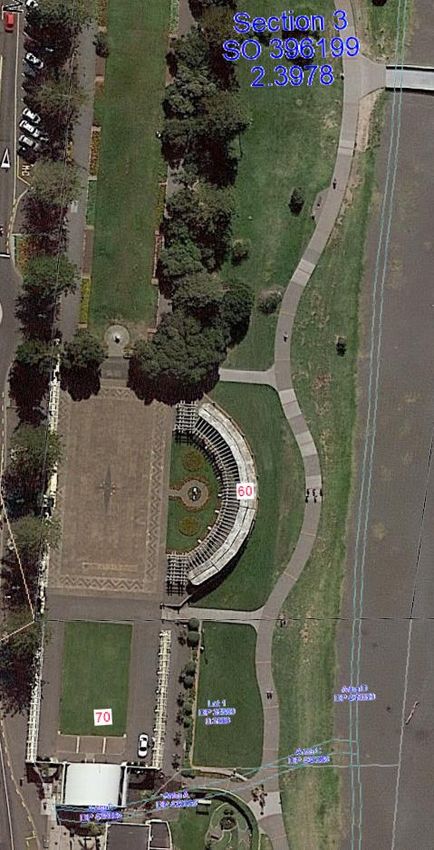
TABLE OF CONTENTS

EXECUTIVE SUMMARY                                                                                            3

1.       IDENTIFICATION                                                                                      4
1.1.     Name of Place                                                                                       4
1.2.     Location Information                                                                                4
1.3.     Legal Description                                                                                   5
1.4.     Extent of List Entry                                                                                5
1.5.     Eligibility                                                                                         5
1.6.     Existing Heritage Recognition                                                                       5

2.       SUPPORTING INFORMATION                                                                              6
2.1.     Historical Information                                                                              6
2.2.     Physical Information                                                                               15
2.3.     Chattels                                                                                           21
2.4.     Sources                                                                                            21

3.       SIGNIFICANCE ASSESSMENT                                                                            22
3.1.     Section 66 (1) Assessment                                                                          22
3.2.     Section 66 (3) Assessment                                                                          23

4.       APPENDICES                                                                                         26
4.1.     Appendix 1: Visual Identification Aids                                                             26
4.2.     Appendix 2: Visual Aids to Historical Information                                                  40
4.3.     Appendix 3: Visual Aids to Physical Information                                                    45
4.4.     Appendix 4: Significance Assessment Information                                                    47

Disclaimer

Please note that entry on the New Zealand Heritage List/Rārangi Kōrero identifies only the heritage values of
the property concerned, and should not be construed as advice on the state of the property, or as a comment of
its soundness or safety, including in regard to earthquake risk, safety in the event of fire, or insanitary
conditions.
Archaeological sites are protected by the Heritage New Zealand Pouhere Taonga Act 2014, regardless of
whether they are entered on the New Zealand Heritage List/Rārangi Kōrero or not. Archaeological sites include
‘places associated with pre-1900 human activity, where there may be evidence relating to the history of New
Zealand’. This List entry report should not be read as a statement on whether or not the archaeological
provisions of the Act apply to the property (s) concerned. Please contact your local Heritage New Zealand office
for archaeological advice.

              Heritage New Zealand Pouhere Taonga – List Entry Report for a Historic Place, List No. 2807          2
EXECUTIVE SUMMARY

Purpose of this report
The purpose of this report is to provide evidence to support the inclusion of the Hawke’s Bay
Earthquake Memorial Complex in the New Zealand Heritage List/Rārangi Kōrero as a Category 2
historic place.

Summary
The Hawke’s Bay Earthquake Memorial Complex, located on Napier’s Marine Parade, comprises of
several structures designed in the 1930s, which together form a public memorial in Napier
commemorating the broad social impact of the 1931 Hawke’s Bay Earthquake. The complex consists of
the Kirk Sundial (1933), Harold Latham Arch (1936), New Napier Arch and Robert Wright Arch (1938),
connecting colonnades (1936-38), and the Veronica Sunbay (1934, rebuilt 1991). The complex’s
historic significance derives from its part in the wider development of Marine Parade, as well as its
importance for memorialising the earthquake and celebrating the rebuild of Napier. The complex has
architectural consistency and significance as each element (with the exception of the sundial) is
designed in the Classical architectural style. A scenic and peaceful place located within sight and sound
of the Napier city-centre and the ocean, the complex has aesthetic significance. It also has social
significance as a site which brings locals and visitors together for recreation or to reflect on the
devastation of the earthquake and Napier’s subsequent rebirth.

Mayor George Swan (1833-1913) had a vision for Marine Parade as a ‘grand esplanade’, like that of a
British seaside town and began developing the Napier seafront with that in mind. This idea was given
new life in the aftermath of the Hawke’s Bay Earthquake when the people of Napier had the unique
opportunity to reconsider the look and design of their township. They built-up and levelled the newly
raised foreshore and built the complex to commemorate both the devastating earthquake and the
courage shown in response to that traumatic event.

The pergola, known as the Veronica Sunbay, encloses the eastern side of the complex. The imposing
New Napier Arch and the two identical but more modest arches, the Harold Latham Arch and the
Robert Wright Arch, line the street-front and are all inscribed with aspirational quotes. The arches are
linked by colonnades which extend north from the Sound Shell at the southern end of the complex
features. All, with the exception of the sundial, are examples of the work of local architect John
Thomas Watson, who went on to become Borough Architect of Napier. Much of the funding came
from local civic group the Thirty Thousand Club, except for the Kirk Sundial, which was designed by

                  Heritage New Zealand Pouhere Taonga – List Entry Report for a Historic Place, List No. 2807   3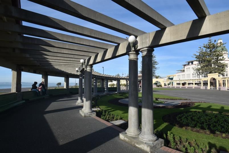
notable architect James Augustus Louis Hay and constructed in 1933, a gift to the town by former
Mayor of Gisborne, James Robert Kirk.

The complex looks much as it did when first built in the 1930s. The Veronica Sunbay became unsafe
and was demolished in 1988. It was entirely rebuilt through community initiatives in 1991 to its
original 1934 design. It continues to be an important and well-used contributing element to this
complex, providing visitors with a sheltered view of the Pacific Ocean. The complex defines and is a key
focus of an important civic space used for events, such as the annual Art Deco Festival, and has social
significance as an iconic part of the commemorative landscape of the Marine Parade.

1.          IDENTIFICATION1
1.1.        Name of Place

             Name
             Hawke’s Bay Earthquake Memorial Complex

             Other Names
             Colonnades Memorial; Circular Bay; Veronica Sunbay; Memorial Arch; New Napier Arch;
             Harold Latham Arch; Robert C Wright Arch; Robert Wright Arch; Kirk Sundial; Spiller
             Reflecting Ball

1.2.        Location Information

             Address
             60-70 Marine Parade
             NAPIER

             Additional Location Information
             New Napier Arch – NZTM Easting: 1937090 Northing: 5621552 (+/- 4m)
             Harold Latham Arch – NZTM Easting: 1937086 Northing: 5621526 (+/- 3m)
             Robert C. Wright Arch – NZTM Easting: 1937093 Northing: 5621579 (+/- 3m)
             Veronica Sunbay – NZTM Easting: 1937125 Northing: 5621550 (+/- 3m)
             Kirk Sundial – NZTM Easting: 1937109 Northing: 5621584 (+/- 3m)
             Northern end of Western Colonnade – NZTM Easting: 1937095 Northing: 5621583 (+/- 3m)
             Southern end of Western Colonnade – NZTM Easting: 1937079 Northing: 5621495 (+/- 4m)

1
    This section is supplemented by visual aids in Appendix 1 of the report.

                   Heritage New Zealand Pouhere Taonga – List Entry Report for a Historic Place, List No. 2807   4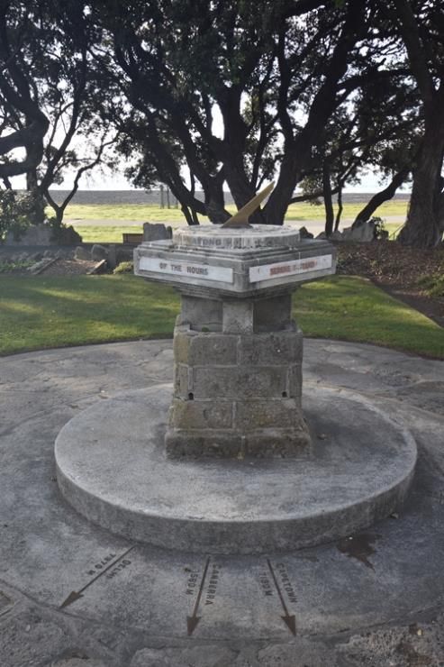
Southern end of Eastern Colonnade – NZTM Easting: 1937114 Northing: 5621489 (+/- 3m)
       Northern end of Eastern Colonnade – NZTM Easting: 1937116 Northing: 5621515 (+/- 3m)

       Local Authority
       Napier City Council

1.3.   Legal Description

       Sec 3 SO 396199 (RT 462213, NZ Gazette 2008, p.5188); Lot 1 DP25889 (RT HBV4/537, NZ
       Gazette 1996, p.4644); Legal Road, Hawke’s Bay Land District.

1.4.   Extent of List Entry

       Extent includes part of the land described as Sec 3 SO 396199 (RT 462213, NZ Gazette 2008,
       p.5188); part of the land described as of Lot 1 DP 25889 (RT HBV4/537 NZ Gazette 1996,
       p.4644); and part of the land described as Legal Road, Hawkes Bay Land District, and the
       structures known as the Kirk Sundial, colonnades, the Harold Latham Arch, the New Napier
       Arch, the Robert Wright Arch and the Veronica Sunbay (including the Reflecting Ball) thereon.
       The extent does not include the central paved area (also known as the skating area) or the
       Sound Shell (see List No. 4822 for both) or the Marine Parade Sea Wall (Former) (see List No.
       1164) as that structure was interrupted for the construction of the colonnade and arches.
       (Refer to map in Appendix 1 of the List entry report for further information).

1.5.   Eligibility

       There is sufficient information included in this report to identify this place. This place is
       physically eligible for consideration as a historic place. It consists of a structure fixed to land
       which lies within the territorial limits of New Zealand.

1.6.   Existing Heritage Recognition

       Local Authority and Regional Authority Plan Scheduling
       Scheduled in City of Napier District Plan, Operative (21 November 2011, as updated)
       Appendix 13: Heritage Items, Ref. No. 123 (New Napier Arch), 181 (The Sunbay) and 182 (The
       Colonnade), Heritage Group 1. Demolition and relocation are discretionary activities.

            Heritage New Zealand Pouhere Taonga – List Entry Report for a Historic Place, List No. 2807      5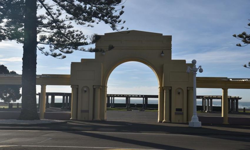
Reserve
              This place is part of a reserve: Local Purpose (Passive Recreation) Reserve (NZ Gazette 2008,
              p.5188.); Local Purpose (Tourist and Visitor Facilities) Reserve (NZ Gazette 1996, p.4644.).

2.           SUPPORTING INFORMATION
2.1.         Historical Information

              Early Napier
              Māori settled in the Hawke’s Bay area relatively early in New Zealand’s history.2 Settlement
              would have been encouraged by food sources which were plentiful both inland, in the
              lagoon, and along the coast. Whatumamoa, Rangitāne, Ngāti Awa and Ngāi Tara became
              established in the areas of Pētane, Te Whanganui-a-Orotū and Waiohiki.3 From the 16th
              century these iwi were displaced by Ngāti Kahungunu, whose influence eventually spread
              from Poverty Bay to as far south as Wellington.4 In the 1840s and 50s contact between these
              iwi and Europeans was limited to the whalers, missionaries and itinerant traders who plied
              their trade along the coast, but in 1851 a key land deal was struck.5 The Ahuriri Purchase was
              negotiated by Land Commissioner Donald McLean on behalf of the Crown.6 It was followed
              by other smaller land purchases in the area.7 Europeans settled in the region to grow crops
              and farm animals and the township of Napier was founded in 1855.8 Other land in the area
              changed hands and by 1859, the Crown had purchased an estimated 1,404,700 acres
              (568,462 hectares) of land from iwi in the area.9

              Napier, in its early days, was an area nearly entirely surrounded by swamp and sea. It was
              described as ‘a precipitous island of barren, uninhabited ridges, covered with fern and rough
              grass, dissected by gorges and ravines, with a narrow strip of shingle skirting the cliffs, and

2
 Kerryn Pollock, 'Hawke’s Bay region - Māori settlement and occupation', Te Ara - the Encyclopedia of New Zealand, 2015,
http://www.TeAra.govt.nz/en/hawkes-bay-region/page-4, accessed 7 May 2020.
3
 Napier City Council, ‘A brief history of Napier’, n.d., https://www.napier.govt.nz/napier/about/history, accessed 7 May
2020.
4
    Kerryn Pollock, 2015, http://www.TeAra.govt.nz/en/hawkes-bay-region/page-4, accessed 7 May 2020.
5
 John Barry Annabell, ‘Planning Napier 1850-1968’ Thesis for Doctor of Philosophy in Planning, Massey University, 2012, p.6,
https://ref.coastalrestorationtrust.org.nz/site/assets/files/7203/02 whole 1.pdf, accessed 7 May 2020.
6
 ‘The Maungaharuru-Tangitū Trust and the Trustees of the Maungaharuru-Tangitū Trust and the Crown, Deed of Settlement
of historical claims: historical account’, 2013, pp.15-16, https://tangoio.maori.nz/wp-
content/uploads/2015/12/Maungaharuru-TangituHapuDOS.pdf, accessed 15 May 2020.
7
    Annabell, 2012, p.6.
8
    Kerryn Pollock, 2015, http://www.TeAra.govt.nz/en/hawkes-bay-places/page-1, accessed 7 May 2020.
9
 Mere Whaanga, 'Ngāti Kahungunu - European contact', Te Ara - the Encyclopedia of New Zealand, 2017,
http://www.TeAra.govt.nz/en/ngati-kahungunu/page-6, accessed 7 May 2020.

                   Heritage New Zealand Pouhere Taonga – List Entry Report for a Historic Place, List No. 2807                 6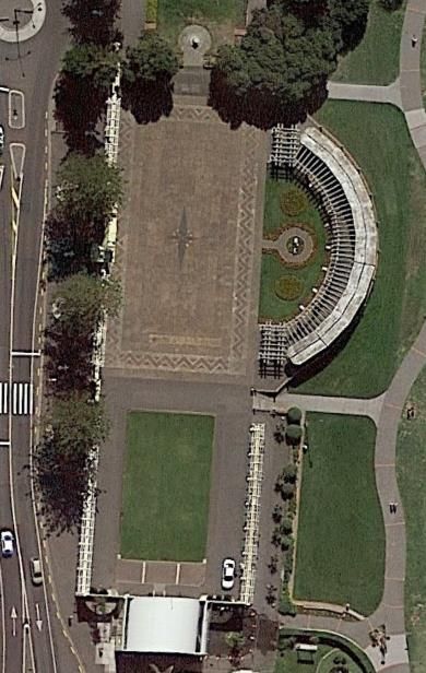
joined to the mainland south by a five mile shingle bank… A hopeless spot for a town site’.10
              Despite this inauspicious assessment, Napier developed to become a busy port town–
              servicing the Hawke’s Bay area and exporting meat, wool and dairy from those working the
              land.11 Napier grew steadily to become the administrative, commercial, and social hub for the
              area.12 It formally changed its status from borough to city in 1950 when its population hit
              20,000.13

              As Napier prospered, Marine Parade (originally called Beach Road) became a feature of the
              waterfront. Mayor George Swan (1833-1913) described a vision he had for the Marine Parade
              – that of a ‘grand esplanade’ inspired by the promenades of iconic British seaside towns.14 To
              this end, he had Norfolk pines planted along the foreshore, footpaths built and a band
              rotunda constructed.15 The township was threatened by encroaching waves during bad
              weather, so Swan’s vision for Marine Parade required a solid seawall and in 1888 the problem
              of the inadequacies of the existing seawall was again before the council.16 Eventually further
              sections of a new seawall were undertaken, with a concrete parapet above the road level,
              constructed with prison labour.17 The final section was finished in 1892 and allowed further
              development along the foreshore.18

              The Earthquake
              By 1930 Napier, like the rest of the nation, was in the grip of the Great Depression, but worse
              lay ahead. On 3 February 1931 Hawke’s Bay was struck by an earthquake measuring 7.8 on
              the Richter Scale; in the townships of Napier and Hastings, and the surrounding district, 256
              people died and countless more were injured.19 In terms of the number of people killed, the
              Hawke’s Bay Earthquake ‘remains the worst civil disaster to have occurred in New Zealand’.20

10
     J.G. Wilson, History of Hawke’s Bay, Christchurch: 1976, p.143.
11
     Michael King, Penguin History of New Zealand Illustrated, Auckland, 2007, p.215.
12
  Kerryn Pollock, 'Hawke’s Bay places - Napier', Te Ara - the Encyclopedia of New Zealand, 2015,
http://www.TeAra.govt.nz/en/hawkes-bay-places/page-1, accessed 7 May 2020.
13
     Annabell, 2012, p.12.
14
     Daily Telegraph, 19 Aug 1886, p.3.
15
     Annabell, 2012, p.312.
16
     Daily Telegraph, 5 Apr 1888, p.2.
17
     Daily Telegraph, 18 Apr 1889, p.2.
18
     Daily Telegraph, 6 Oct 1892, p.3.
19
  Eileen McSaveney, 'Historic earthquakes - The 1931 Hawke’s Bay earthquake', Te Ara - the Encyclopedia of New Zealand,
2017, http://www.TeAra.govt.nz/en/historic-earthquakes/page-6, accessed 5 May 2020.
20
  'Hawke's Bay earthquake strikes', Ministry for Culture and Heritage, https://nzhistory.govt.nz/hawkes-bay-earthquake-0,
updated 4 Aug 2017.

                    Heritage New Zealand Pouhere Taonga – List Entry Report for a Historic Place, List No. 2807             7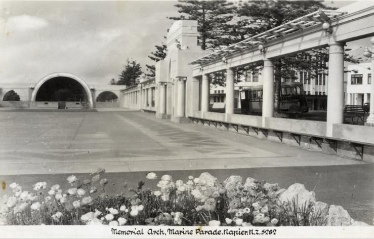
The earthquake destroyed many buildings beyond repair, particularly in the Napier city
              centre, and the fires and aftershocks that followed the earthquake contributed to further
              devastation. Historian Michael King wrote that in the surrounding area ‘whole hillsides
              disappeared, rivers were dammed, great fissures appeared in the earth and ran for
              kilometres’.21 In places land was uplifted by eight feet.22 The challenge of organising the
              rebuild of Napier was taken on by magistrate John Saxon Barton and engineer Lachlan Bain
              Campbell, who worked in collaboration with local committees.23 They worked to restore
              crucial services, clear debris, issue permits for building repairs and restart the area’s
              economy.24

              Post-earthquake, the local government and the people of Napier were in the unique situation
              of being able to reconsider the look and design of their township. Commissioner Barton
              argued that they should seize the ‘glorious opportunity to correct the errors of the past and
              have a well-laid-out town’.25 Prior to the earthquake, architectural styles in Napier were
              already moving away from Victorian and Edwardian styles, but new building regulations post-
              earthquake embedded a focus on seismically resistant materials, such as reinforced concrete
              and reduced ornamentation, especially for commercial and public buildings and structures.26
              Although Stripped Classical continued to be a dignified choice for banks and public
              structures, and Moderne and Spanish Mission styles were also popular, the overwhelming
              choice was Art Deco. This style had the advantage of being a fashionable, safe form of
              building which was inexpensive to construct.27

              The recently uplifted foreshore provided new space for the town’s development. Debris from
              the devastated Napier town centre was shifted to the water’s edge to build up and level what
              is now the foreshore. Workers, employed under a Great Depression work scheme organised

21
     King, 2007, p.308.
22
  Napier City Council, ‘A brief history of Napier’, n.d., https://www.napier.govt.nz/napier/about/history, accessed 7 May
2020.
23
  Eileen McSaveney, 'Historic earthquakes - Rebuilding Napier', Te Ara - the Encyclopedia of New Zealand,
http://www.TeAra.govt.nz/en/historic-earthquakes/page-8, accessed 5 May 2020.
24
     Annabell, 2012, p.155.
25
     “The re-planning of Napier”, Community Planning, 2:3, 1932, p.73.
26
  For example, Napier’s Chief Post Office, completed in 1930, was an early exercise in the Public Works Department’s drive
to develop earthquake resistant buildings, following the Murchison Earthquake of 1929. The Post Office’s design was a
success, withstanding the Hawke’s Bay Earthquake, but being subsequently damaged by fires in the aftermath. The building’s
architectural style was Stripped Classical.
27
     Robert McGregor, The Art Deco City, Napier: Art Deco Trust, 1998, p.2.

                    Heritage New Zealand Pouhere Taonga – List Entry Report for a Historic Place, List No. 2807              8
by the Napier Borough Council Parks and Reserves Department, mixed the rubble with local
              limestone, clay and topsoil to create an entirely new space.28 Large sections of the, now
              unnecessary, seawall were demolished.29

              Marine Parade develops
              The 1930s saw extensive development along Marine Parade in the form of both structures
              and gardens. This redevelopment was not just central government of local council-led. In
              particular, community and civic clubs were integral to the development of Marine Parade.
              The Rotary Club of Napier, established in 1924, was active in the reconstruction. The Club
              President at the time said that ‘no Rotary Club ever had a better opportunity of rendering
              service to its community than that presented at the moment.’30 The Thirty Thousand Club
              also had a vision for this area. Formed in February 1912 to motivate a township ‘tired with
              the drowsiness of doing nothing’, the Club was a community service organisation which
              worked to support the tourism and economic development of Napier.31 Their founding goal
              was to increase the population of Napier to 30,000 at a time when the township was less
              than 15,000.32 It sought to foster the ‘spirit of civic pride and enthusiasm’ within Napier.33
              Prior to the earthquake, their most notable project had been the installation of lighting along
              the Marine Parade in 1914.34 The Thirty Thousand Club funded the Veronica Sunbay,
              colonnades and arches, structures grouped around the adjacent Sound Shell and Skating Rink
              that were constructed from 1932-1934 (List No. 4822, Historic Place Category 2).

              Some of these new features took on new meaning as symbols of the rebirth of the city.35
              Landscape historian Robin Woodward writes that this memorial landscape:

                      ‘…trumpeted Napier’s intention not just to rise from the rubble and ashes of the
                      earthquake and fires, but to reinvent itself in the process. Not from Brighton Beach did

28
     Hawkes Bay Today, 20 Feb 2016, p.14.
29
  ‘Marine Parade, Napier’, Post, 3 Feb 1931, MTG Hawke’s Bay Collection,
https://collection.mtghawkesbay.com/objects/72517, accessed 15 May 2020. For further information about the seawall see
report for Marine Parade Sea Wall HNZPT List No. 1164. https://www.heritage.org.nz/the-list/details/1164
30
     ‘Rotary Club of Napier’, https://www.rotarynapier.org, accessed 5 June 2020.
31
  Michael Fowler, Hastings, Havelock North and Napier: a collage of history, Havelock North: Michael Fowler Publishing
Limited, 2015, p.142.
32
  Annabell, 2012, p.236. They were to achieve their population target 56 years later, but the Club elected to continue in
operation until the mid-1970s (Annabell, 2012, p.237).
33
     Poverty Bay Herald, 16 Nov 1912, p.2.
34
     Poverty Bay Herald, 2 Feb 1914, p.3.
35
     Robin Woodward, Cultivating Paradise: Aspects of Napier’s Botanical History, Napier: 2002, p.28.

                   Heritage New Zealand Pouhere Taonga – List Entry Report for a Historic Place, List No. 2807              9
this design come – but from tinsel town, from Hollywood. And with it went the
Veronica Sun Bay, a colonnade, three grand arches – including the so-called ‘New
Napier Arch’ and, most daring of all – an outdoor dancing area … Napier was being
restyled as a modern city of the future, a place for fun and pleasure.’36
The Hawke’s Bay Earthquake Memorial Complex is not the only earthquake memorial in
Napier. The remains of 101 of the Napier victims of the earthquake were interred in a
common grave at Napier’s Park Island Recreation Ground. Prominent Napier architect James
Augustus Louis Hay designed an associated memorial, in the form of an obelisk, which was
erected there in 1932.37 Hay was an important figure after the earthquake because he was a
member of the Napier Reconstruction Committee and part of the group of local architects
who banded together to come up with a coordinated architectural approach to the rebuild.38
In a separate undertaking, the Rotary Club of Ahuriri commissioned artist Frank Szirmay to
construct a sculpture celebrating the rebirth of the city. His ‘Spirit of Napier’ was unveiled in
1971, overlooking the southern part of Marine Parade.39 While the Park Island memorial
focusses on loss, the Spirit focusses on hope for the future. The Hawke’s Bay Earthquake
Memorial Complex embraces both these aspects.
Kirk Sundial
The Kirk Sundial was the first of the Hawke’s Bay Earthquake Memorial Complex’s group of
elements to be installed. It was also constructed in 1933 also to a design by Louis Hay. The
sundial was a gift from James Robert Kirk, former Mayor of Gisborne, who was ‘struck with
the spirit of rehabilitation’ in Napier.40 This sentiment was echoed by the inscription:
‘Calamity is man’s true touchstone’ incised on a bronze plate. On the top section are two
additional inscriptions: ‘Serene I stand amid the flowers to tell the passing of the hours’ and
‘Smiles equal sunshine in helping folks along’. The Poverty Bay Herald described the
36
Woodward, 2002, p.29.
37
‘Napier Earthquake Memorial’, https://nzhistory.govt.nz/media/photo/napier-earthquake-memorial, accessed 3 Sept
2020.
38
Peter Shaw. ‘Hay, James Augustus Louis’, Dictionary of New Zealand Biography, first published in 1998. Te Ara - the
Encyclopedia of New Zealand, https://teara.govt.nz/en/biographies/4h20/hay-james-augustus-louis (accessed 31 August
2020)
39
‘Rotary Club of Ahuriri’, http://www.ahuriri-rotary.org.nz/spirit/spirit.html, accessed 3 Sept 2020.
40
‘The History and Development of the Parks, Gardens and Recreation Grounds of Napier’, Conference Paper, Napier, 1947.
copy held on HNZPT Central Region file 12018-156.
Heritage New Zealand Pouhere Taonga – List Entry Report for a Historic Place, List No. 2807 10structure: ‘the bronze arrows have been inserted in the bottom concrete steps, the great
cities and notable places of the Empire, their directions and distances being indicated’.41
Veronica Sunbay
The next element of this memorial complex was the Veronica Sunbay, which was
constructed in 1934.42 It was originally called the Circular Bay.43 The structure was built to a
design drawn up by John Thomas Watson.44 Watson was originally from England. He initially
worked in Napier in private practice, but went on to become the Napier Borough Architect
and designed many buildings around Napier in that capacity.45 One of his best known designs
is the Art Deco Municipal Theatre (1938). His design for the Sunbay was one of his early
works. It consists of a flat-roofed curved pergola with seating where visitors could relax and
enjoy a sheltered view of the sea.46 The construction was funded mainly by the Thirty
Thousand Club and the Borough Council, with smaller contributions from the Carnival
Committee and Retailers’ Association.47 It ran over budget to a total cost of just over
£1,400.48
The structure became a memorial when it was renamed the ‘Veronica Sunbay’ in 1937. It
was named in honour of the crew of the HMS Veronica who provided crucial assistance as
first responders in the aftermath of the earthquake. The Naval ship was berthed at Port
Ahuriri when the earthquake struck its crew were the first to report the event, by the ship’s
Morse Code.49 The sailors then went onshore and are remembered as ‘brave, disciplined and
efficient’ as they bought ‘renewed order and confidence to the stricken town’.50 Their ship’s
bell was gifted to the city as a reminder of the events of the earthquake and hung beneath
the ‘VERONICA’ signage on the Sunbay. During the New Zealand Centennial celebrations in
41
‘Untitlled’, Poverty Bay Herald, 5 Aug 1933, p.7.
42
‘Veronica Sunbay’,Napier City Council, https://www.napier.govt.nz/napier/memorials/napiers-memorials/, accessed 11
June 2020.
43
Napier Borough Council Minutes of Ordinary Meeting 15 December 1930 to 11 March 1935, Code A49-0009-28, p.529,
Napier City Council Archives.
44
ibid., p.339.
45
‘Obituary Mr JT Watson’, Napier Daily Telegraph, 12 Dec 1960.
46
Annabell, 2012, p.313.
47
Napier Borough Council Minutes of Ordinary Meeting 15 December 1930 to 11 March 1935, Code A49-0009-28, p.575,
Napier City Council Archives.
48
ibid., p.623
49
Michael Fowler, ‘Quake-hit Napier thanked God for Rpyal Navy’, Hawke’s Bay Today, 3 Feb 2018,
https://www.nzherald.co.nz/hawkes-bay-today/opinion/news/article.cfm?c_id=1503459&objectid=11986734, accessed 31
Aug 2020.
50
M Campbell, The Story of Napier: 1874-1974, Napier City Council: 1975, p.133.
Heritage New Zealand Pouhere Taonga – List Entry Report for a Historic Place, List No. 2807 111940 three painted panels were temporarily fixed on the top of the Sunbay. They depicted
the arrival of an immigrant ship, two men in a waka and the ruins of a building and the New
Zealand coat of arms.51 The bell was removed from the Sunbay in the 1990s, due to
vandalism, and in 1998 it was provided on loan to MTG Hawke’s Bay Tai Ahuriri’s collection.52
It is rung ceremonially at New Years and during the annual Art Deco festivities.
The original stainless steel reflecting bowl, situated in centre of the Sunbay’s circular garden,
was removed at some point in the 1970s.53 In March 1993 a new Art Deco-inspired, polished,
stainless steel ball was gifted to Napier by Corinne and Russ Spiller in memory of Percy Spiller
MBE.54 Percy Spiller was one of the original members of the Napier Frivolity Minstrels. In this
capacity, he served at various times as performer, secretary and producer. For thirty years he
was also secretary of the Thirty Thousand Club and the Napier Competition Society. After the
1931 Hawke’s Bay Earthquake he served as the secretary of the Napier Reconstruction
Committee.55 Given his close connection to these local groups, the complex is a fitting place
to honour his memory.
Arches and colonnades
These arches and colonnades, like the Veronica Sunbay, were designed by John Thomas
Watson.56 The three arches and the colonnades which link them are a central feature of the
memorial space. Like the Sunbay, they were designed in a Classical architectural style and
partially enclose the complex. The first phase of construction was in 1936, and included the
Harold Latham Memorial Arch, the Sound Shell and the colonnades that link the two, as well
as the colonnade on the eastern side. Two years later in March 1938 it was decided to extend
the western colonnade and construct two additional arches at a total cost of £780.57 One of
these arches was to be identical in size and proportion to the existing Latham Memorial Arch
and called the ‘Robert C. Wright Arch’. Both Latham and Wright had recently passed on at
the time of construction, having been active members of the Thirty Thousand Club who
sought to develop the Marine Parade.58 Wright was a former member of the Hawke’s Bay
51
‘Veronica Sunbay, Napier’, https://collection.mtghawkesbay.com/objects/76654, accessed 24 June 2020.
52
Email from Sara Perrett, Collections Coordinator MTG Hawke’s Bay, 2 Sept 2020.
53
‘Ordinary and Committee minutes 29 July 1991 to 20 December 1991’, Doc ID 348955, Napier City Council Archives.
54
‘Reflecting Ball’, https://www.napier.govt.nz/napier/memorials/napiers-memorials/, accessed 3 Sept 2020.
55
‘Percy Spiller, MBE’, https://knowledgebank.org.nz/text/percy-spiller/, accessed 2 August 2020.
56
Geoff Mew and Adrian Humphris, Raupo to Deco: Wellington Styles and Architects 1840-1940, Wellington, 2014, p.277.
57
Hawke’s Bay Today, 20 Feb 2016, p.14.
58
Annabell, 2012, p.313.
Heritage New Zealand Pouhere Taonga – List Entry Report for a Historic Place, List No. 2807 12Education Board.59 Both ‘had seen the possibility of making the Marine Parade an
outstanding resort’.60 As at March 1938 the Poverty Bay Herald reported that the larger
central arch was yet unnamed.61 The suggestion of ‘Arch of Remembrance’ was rejected and
it was finally settled on the name ‘New Napier Arch’.62 It was completed in 1939.63 In
accordance with the commemorative complex’s theme of resilience and recovery, each of the
three arches is inscribed with an aspirational quote. On the more imposing and dominant
central New Napier Arch is the writing ‘Courage is the thing: all goes when courage goes’.
This quote was coined in 1922 by J.M. Barrie, a playwright and writer (most famous for his
character Peter Pan).64 The Latham Arch is inscribed with ‘Without vision the people perish’
and the Wright Arch with ‘The pathway to power lies through service’. In this context they
are a reflective tribute to the resilience of Napier during its ‘darkest days’, as it ‘celebrates
triumph over adversity as well as the enduring nature of human courage and perseverance’.65
Use
The complex has fulfilled its original purpose by becoming a landmark and focal point on the
Marine Parade and as a dedicated recreational space. In the 1930s and 40s, people had
limited access to transportation by car and this area was an accessible space in the central
business district (CBD).66 Since then, people of all ages have gathered to walk, rest, enjoy
views of the ocean and sit in the Sunbay or on the colonnade seating to watch people
dancing, skating for leisure and competition or watch concerts. The iconic Howard Morrison
Quartet was just one of the acts which performed in the Sound Shell in the early 1960s, with
the New Napier Arch and the complex’s other structures as a backdrop.67 A wide variety of
more recent performances have included the Royal New Zealand Navy Concert, Diwali,
Matariki Festival, Christmas concerts, New Year’s Eve fireworks displays, musical
performances and theatrical productions.68
59
‘Obituary’, Evening Post, 27 March 1937, p.15.
60
Annabell, 2012, p.313.
61
Poverty Bay Herald, 4 Mar 1938, p.4.
62
Undated document, ARC-0543, NCC-01926, Archive Box No: 172, File No: [9/29], File Name: 9/29 Sound Shell – Auditorium,
1934-1976, Napier City Council Archive.
63
‘Colonnade and Arches,’ Daily Telegraph, 20 January 1939, copy held on HNZPT Central Region file 12018-156.
64
‘Tales of courage in tragedy echoes heroism of the past’, Napier Mail, 2001.
65
Ian Lochhead, ‘Art Deco Napier: An assessment of Outstanding Universal Value for the New Zealand World Heritage
Tentative List’, Department of Conservation, Aug 2011, p.32.
66
Robert McGregor, The Art Deco City, Napier, New Zealand, Napier, 1998, p.40.
67
‘Historic Hawke’s Bay: Mardi Gras festival envy of other towns’, New Zealand Herald, https://www.nzherald.co.nz/hawkes-
bay-today/opinion/news/article.cfm?c_id=1503459&objectid=12168329, accessed 8 June 2020.
68
‘Napier Soundshell’, Eventfinda, https://www.eventfinda.co.nz/venue/napier-soundshell, accessed 8 June 2020.
Heritage New Zealand Pouhere Taonga – List Entry Report for a Historic Place, List No. 2807 13Yet it is the Art Deco Festivities to which this complex has become indelibly linked. The Art
Deco Group formed in 1985 and was incorporated in 1987 as the Art Deco Trust. Their
mission is ‘to be committed to the preservation, restoration, promotion and celebration of
Napier’s Art Deco era heritage’.69 The group organises regular guided tours of the Napier CBD,
but their flagship event is the Art Deco Festival held each February, marking the anniversary
of the earthquake. With help from around 120 volunteers, the Festival has flourished as a
fixture on the Hawke’s Bay social calendar.70 The complex defines a popular venue for jazz
concerts, parades, picnics, fashion shows and the Depression Dinner.71 The Festival has grown
rapidly in popularity and has been described as putting Napier ‘not just on the map, but the
globe’.72
Although these elements all look very similar in appearance to how they looked when they
were constructed in the 1930s, the Sound Shell, colonnade and arches have all undergone
work to be ‘restored to their former glory’.73 However, it is the Veronica Sunbay which has
undergone the most change to stay the same. By the late 1980s the Sunbay had become
badly corroded, which meant it was completely demolished. It was then entirely rebuilt to
the original design in 1991 with funding from the Rotary Club of Napier, Napier City Council
and private donations.74 The total reconstruction cost for the Veronica Sunbay was $200,000
- the Rotary Club saved $20,000 by undertaking the demolition work themselves.75 A
ceremony to rededicate the Sunbay was held on the 60th anniversary of the earthquake in
1991.76 The ongoing care for these structures indicates the esteem in which the complex is
held.
The complex is significant to the people of Napier as a place which marks their shared past
and identity forged through the experience of the earthquake and rebuild. The continued
69
‘Art Deco Trust’, https://www.artdeconapier.com/The+Trust.html, accessed 11 June 2020.
70
ibid.
71
‘World Famous in New Zealand: Art Deco Festival, Napier’, Stuff, 2019,
https://www.stuff.co.nz/travel/destinations/nz/109864320/world-famous-in-new-zealand-art-deco-festival-napier, accessed
8 June 2020.
72
McGregor, The Art Deco City: Napier, New Zealand, Napier: 1998, p.5.
73
Woodward, 2002, p.31.
74
‘Veronica Sunbay and Soundshell’, https://knowledgebank.org.nz/still_image/veronica-sunbay-and-soundshell-
3/?searchterm=sunbay, accessed 1 May 2020.
75
‘Bell rings in new sun bay’, Daily Telegraph, 1 Jul 1991, p.37.
76
‘Veronica Sunbay and Soundshell’, https://knowledgebank.org.nz/still image/veronica-sunbay-and-soundshell-3/,
accessed: 25 June 2020.
Heritage New Zealand Pouhere Taonga – List Entry Report for a Historic Place, List No. 2807 14importance of this experience is evident from anniversary celebrations in 1981 and 1991
when many gathered at the complex to mark the earthquake’s 50th and then 60th
anniversary.77 The complex continues to be a meaningful memorial and ‘enduring asset’ to
the people of Napier.78
Associated List Entries
Skating Rink (Former) and Sound Shell, Napier (List No. 4822)
Napier City Centre Historic Area (List No. 7022)
2.2. Physical Information
Current Description
Context
The Hawke’s Bay Earthquake Memorial Complex is located towards the northern end of
Marine Parade on Napier’s waterfront. This section of the coastline is long, straight and flat.
The complex is situated within sight and sound of the Pacific Ocean and is aligned to be
within easy access to the Napier CBD. This complex is part of a number of other memorial
structures along Marine Parade. Situated north of the Hawke’s Bay Earthquake Memorial
Complex is the 1918 Swan Memorial Pool Shelter (List No. 1165, Historic Place Category 2),
the 1897 Flood Heroism Memorial (List No. 1115, Historic Place Category 2), the Napier War
Memorial and Conference Centre and the Tom Parker Fountain. West of the complex is the
South African War Memorial (List No. 1111, Historic Place Category 2). To its south is the
1971 Spirit of Napier, which also memorialises the town’s response to the Hawke’s Bay
Earthquake. The complex sits within the Napier City Centre Historic Area (List No. 7022).
Shaded on its western side by regularly planted mature Norfolk Island pine trees, the
Hawke’s Bay Memorial Complex is built around a central paved area which is very worn with
uneven concrete pavers in a faded, Art Deco pattern with a star-shape at its centre and a red
and grey zigzag border. The Kirk Sundial is located to the north of this plaza space. The Sound
Shell, a stage set within a circular dome, sits to the south of the area, but faces north.
Matching colonnades, running parallel to each other, extend north from the Sound Shell. The
77 th
‘Commemorative Service 50 anniversary of the H.B. Earthquake 1981’, Napier Earthquake Commemoration Committee,
1981; ‘Veronica Sunbay and Soundshell’, https://knowledgebank.org.nz/still image/veronica-sunbay-and-soundshell-3/,
accessed: 25 June 2020.
78
Woodward, 2002, p.31.
Heritage New Zealand Pouhere Taonga – List Entry Report for a Historic Place, List No. 2807 15extension of the western colonnade links the Harold Latham Arch, the New Napier Arch, and
Robert Wright Arch. To the east of the complex the Veronica Sunbay overlooks the sea.
Between the eastern, seaward colonnade and the Veronica Sunbay is a flight of steps down
to the beach. Despite its proximity to the busy inner-city of Napier, this complex is an area
which is both peaceful and scenic.
Kirk Sundial
Louis Hay designed the Kirk Sundial located at the northern extent of the memorial and at
the southern end of a strip of lawn edged with flower gardens. It is made of marble, bronze,
limestone and concrete. The structure, completed in 1933, sits on a low platform in the
centre of a circular area of crazy paving. The sundial is approximately 1.5 meters in height. On
the southern face of the plinth it has a bronze plate inscribed with ‘Calamity is man’s true
touchstone’. Another small bronze plaque below this indicates it is ‘The Gift of J.R. Kirk Esq
MBE 1933’. Bronze arrows on the bottom concrete steps point to major cities, notable places
in the Empire and their distances. On the marble sundial face is inscribed with ‘Smiles equal
sunshine in helping folks along’ and on the square base is ‘Serene I stand amidst the flowers
to tell of the passing of the hours’. Instruction on the dial directs the reader to calculate the
time by looking at the shadow of the bronze gnomon on the weathered marble dial.
Veronica Sunbay
The Veronica Sunbay is a curved, pergola structure on the eastern, seaward side of this
complex, built in 1934.79 It was designed by Napier architect John Thomas Watson.80 Like the
colonnade and arches, he designed it in a Classical architectural style. There are two groups
of 16 polished concrete Doric columns set in groups of four at the northern and southern
ends. They support an open roof of concrete beams and crossing rafters. These groupings are
linked to each other by a further eight pairs of Doric columns and rectangular concrete
supports for a partial roof on the seaward side. Each Doric column and each concrete support
has a small dedication plaque at the base of each, acknowledging benefactors who
contributed to the cost of the structure. The Sunbay has seating on both seaward and inland
sides and window openings through which visitors can enjoy a view of the ocean protected
from the elements by the shallow roof. There are Art Deco globe lights fixed to both sides of
79
‘Veronica Sunbay’, Napier City Council, https://www.napier.govt.nz/napier/memorials/napiers-memorials/, accessed 11
June 2020.
80
Napier Borough Council Minutes of Ordinary Meeting 15 December 1930 to 11 March 1935, Code A49-0009-28, p.339,
Napier City Council Archives.
Heritage New Zealand Pouhere Taonga – List Entry Report for a Historic Place, List No. 2807 16the Sunbay. The signage ‘VERONICA’ is mounted above the central, west-facing concrete
beam. The Sunbay curves around a tidy lawn with garden plantings, a central paved area with
brick edging, large dedication plaque. It reads:
‘Originally erected in 1934 to commemorate the Hawke's Bay earthquake of 3rd
February 1931, this memorial is named in honour of HMS Veronica and the
outstanding service given by her officers and crew at the time of the disaster.
Rebuilding of the Sun Bay was accomplished through the initiative and leadership of
the Rotary Club of Napier and contributions from the citizens of Hawke's Bay and the
Napier City Council. This plaque was unveiled at the dedication of the rebuilt
memorial, which took place on the Sixtieth Anniversary of the earthquake - 3rd
February 1991.’
A polished, stainless steel reflecting ball sits, on a plinth, in the centre of the circular floral
garden on the western side of the Sunbay. It creates a visual focal point and reflects the
colours and shapes of the environment around it.
Inscribed on a plaque on the wall of the Sunbay is a poem written by Gertrude Ryder
Bennett, describing similar destruction caused by the San Francisco earthquake, half a world
away in 1905:
‘I never understood how man could dare
To watch a city shaken to the ground,
To feel tremors, hear the tragic sound
Of houses twisting, crashing everywhere
And not be conquered by a sick despair.
Within my soul I made my towers high.
They lie in ruins, yet I have begun
To build again, now planning to restore
What life has shaken to the Earth; and I
In faith shall build my towers toward the sun,
A stronger city than was there before.’
Heritage New Zealand Pouhere Taonga – List Entry Report for a Historic Place, List No. 2807 17In 1995 the glass panes in the Sunbay were permanently removed after vandals repeatedly
broke them.81
Latham and Wright Arches
The Harold Latham and Robert C. Wright Arches are relatively modest in scale, Classical-
inspired memorial arches, also designed by Watson. They are linked by a Classical style
colonnade that runs north to south connecting to each other, the New Napier Arch between
them, and the Sound Shell at the south. Each side of the semi-circular arch is supported by a
simple capital at the top of a column set against the Doric column of the colonnade. The
Harold Latham Arch was constructed in 1936 and the Robert C. Wright Arch completed in
1939. The only visual difference between the two arches is their inscriptions on their
pediments which face the Marine Parade road. The Latham Arch is inscribed with ‘Harold
Latham Arch’ above the arch and with ‘Without vision the people perish’ on the pediment.
The Robert Wright Arch further north is inscribed with ‘Robert C Wright’ above the arch and
with ‘The pathway to power lies through service’ inscribed on the pediment. The arches are
plain, but ornamented with dentils on both the seaward side and the city side of each arch.
New Napier Arch
The central New Napier Arch is the centrepiece of the memorial complex and was specifically
designed to be reminiscent of a Classical triumphal arch, because of its associations with
victory and overcoming adversity. Built in concrete, it is located between the Latham and
Wright arches and linked to them by the colonnade. This arch also faces the Marine Parade
road and is more ornate and substantial than the other two. It’s two Doric columns are
symmetrically placed on either side of the arch, each capped with a volute. The intrados of
the arch has recessed patterning. There are four electric lights on each side of the arch within
arched niches and one upper pair just below, an ornate fascia and frieze which in turn is
surmounted by the pediment. The text above the arch on the city side reads: ‘New Napier
Arch’ and the on the pediment reads: ‘Courage is the thing: all goes if courage goes’. The arch
is painted in yellow and purple, with inscriptions picked out in white. There is no inscription
on the seaward side. At the bottom of the street side of the Arch is a plaque which reads:
‘The Colonnade & Sound Shell Presented by the Napier Thirty-Thousand Club Inc. J.T.
Watson FIAA Architect Napier.’
81
‘Ordinary and Committee Minutes 5 April 1995-28 June 1995’, Doc ID 350010, Napier City Council Archive.
Heritage New Zealand Pouhere Taonga – List Entry Report for a Historic Place, List No. 2807 18Colonnades
There are two sections of colonnade in this complex, designed by Watson and constructed in
1936 and 1939, which echo the architectural style of the adjacent Veronica Sunbay. They are
both designed in Classical style and, like the arches, are reinforced concrete which has been
painted. The western colonnade links the northern extent to the Robert C Wright Arch, the
New Napier Arch and the Harold Latham Arch in turn to the Sound Shell. A shorter matching
section, without arches, sits on the other side of the rectangular central lawn, starting by the
southern end of the Veronica Sunbay, also terminating at the Sound Shell. Both sections of
colonnade run on a north-south line parallel to the foreshore and Marine Parade road. A low
concrete wall connects each Doric column. Stretched above and along the length of the
columns is a concrete band supporting an awning of painted wooden slats.
Both sections of colonnade have green timber seating facing inwards to the lawn. The
colonnade seating may have been added some time after the construction of the colonnades
themselves.82 The identically designed seating fixed to the longer northern section of the
western colonnade may have been built earlier, possibly as part of the original design. By
1945 plans were afoot to develop new ‘foundations, floodlighting, seating, fencing and
shelters’ around the colonnade.83 The seating was in place by the 1950s and well-used by
recreational skaters. The hooks from which the 78 gramophone speakers were hung are still
evident on the colonnade.84 There are regularly spaced Art Deco globe lights and several
modern electric lights positioned to light up the auditorium space and Sound Shell for
evening events. The colonnades and their seating are painted in yellow, purple and green,
typical Art Deco colours – bold, lively, and energetic. In 1994 Apacs undertook repairs to the
plasterwork and beams on the arches and colonnade at a cost of $30,000.85
Construction Professionals
James Augustus Louis Hay (Architect, Kirk Sundial)
John Thomas Watson (Architect, Latham, Wright and New Napier Arches, colonnades and
Veronica Sunbay)
82
‘Colonnades Memorial, Marine Parade, Napier, https://collection.mtghawkesbay.com/objects/78093, accessed 21 August
2020.
83
Campbell, 1975, p.180.
84
‘Wheels still turning despite a new era’, Daily Telegraph, 15 Feb 1997, p.26.
85
‘Columns getting $30,000 facelift’, Daily Telegraph, 26 Mar 1994, copy held on HNZPT Central Region file 12018-156.
Heritage New Zealand Pouhere Taonga – List Entry Report for a Historic Place, List No. 2807 19Construction Materials
Veronica Sunbay – reinforced concrete plaster, timber seating, glass globe lamps
Arches and colonnade – reinforced concrete plaster, timber seating, timber awning, glass
globe lamps
Kirk Sundial – bronze, marble, concrete and limestone
Key Physical Dates
1933 Kirk Sundial constructed
1934 Veronica Sunbay constructed
1936 Harold Latham Arch and colonnades from Sound Shell constructed
1938 Western extension of Colonnade and New Napier Arch and Wright Arch
constructed
c. 1945 Seating added to the colonnade
1988 Veronica Sunbay demolished
1991 Veronica Sunbay rebuilt in replica
1994 Plasterwork and beams of arch and colonnade are repaired and resealed
Uses
Civic Facilities – Archway
Civic Facilities – Sundial
Civic Facilities – Garden
Civic Facilities – Recreation Area/Picnic Ground
Civic Facilities – Shelter
Civic Facilities – Square – Public
Civic Facilities – Wall/Fence
Commemoration – Monuments, memorial, site of particular event – other
Commemoration – Memorial – Disaster
Commemoration – Memorial gate/fence/wall/arch
Commemoration – Memorial – Particular person or group
Commemoration – Memorial marker/plaque
Commemoration – Site of a particular event
Cultural Landscape – Streetscape
Heritage New Zealand Pouhere Taonga – List Entry Report for a Historic Place, List No. 2807 202.3. Chattels
There are no chattels included in this List entry.
2.4. Sources
Sources Available and Accessed
Secondary sources on the history of Napier have been accessed, including M. Campbell’s
1975 publication Story of Napier 1874-1974: Footprints along the shore, and entries on the
Manatū Taonga Ministry for Culture and Heritage websites NZ History and Te Ara –
Encyclopedia of New Zealand. Both national and local historic newspapers have been
accessed online through Papers Past. Digitised photos have also been accessed from the
Alexander Turnbull Library, Upper Hutt City Libraries, MTG Hawke’s Bay. Material was also
sourced from the Napier City Council Archives.
Site visits were conducted on 4 and 5 August 2020.
Further Reading
Annabell, John Barry. ‘Planning Napier, 1850-1968,’ Thesis, Doctor of Philosophy in Planning,
Massey University, 2012,
http://ref.coastalrestorationtrust.org.nz/site/assets/files/7203/02_whole_1.pdf, accessed 8
May 2020.
Campbell, M. Story of Napier 1874-1974: Footprints along the shore, Napier: Napier City
Council, 1975.
McGregor, Robert. The Art Deco City: Napier, New Zealand, Napier: Art Deco Trust, 1998.
McGregor, Robert. The New Napier: The Art Deco City in the 1930s, Napier: Art Deco Trust,
1999.
Woodward, Robin. Cultivating Paradise: Aspects of Napier’s Botanical History, Napier:
Hawke’s Bay Cultural Trust, 2002.
Heritage New Zealand Pouhere Taonga – List Entry Report for a Historic Place, List No. 2807 213. SIGNIFICANCE ASSESSMENT86
3.1. Section 66 (1) Assessment
This place has been assessed for all criteria, and found to possess aesthetic, architectural,
historical and social significance or value. It is considered that this place qualifies as part of
New Zealand’s historic and cultural heritage.
Aesthetic Significance or Value
The Classical and Art Deco styling of the Hawke’s Bay Earthquake Memorial Complex’s
structures unites them to create a cohesive sense of place within a wider recreational and
commemorative landscape. Located against the backdrop of the sparkling sea and
surrounded by gardens and promenades, the place feels both peaceful and timeless,
promoting reflection and contemplation in the visitor. The grandeur of the Classical
colonnade and employment of the ‘triumphal arch’ element invokes sentiments of grief for
the memory of the lost, civic pride for the town and hope for a brighter future.
Architectural Significance or Value
The Hawke’s Bay Memorial Earthquake Complex has architectural significance because of the
design of the place, with its Classically-inspired triumphal arches, colonnades and sunbay, is a
continuance of the architectural vocabulary typically used for important public monuments
and buildings. Notable architect John Thomas Watson adapted this to the aesthetic of the
1930s era by restraining the ornamentation, without sacrificing grandeur.
Historical Significance or Value
This group of structures has historical significance for their association with the 1931 Hawke’s
Bay Earthquake, a nationally significant event and a turning point for the history and
development of Napier and the Hawke’s Bay area. They are part of the wider development
along Napier’s Marine Parade in the 1930s that was made possible by land having been
raised by the earthquake, and the hard work and vision of those who were determined to
make the best of the opportunities of the rebuild. Much of this work was funded by civic
groups - particularly the Napier Thirty Thousand Club who had a significant influence on the
development and promotion of Napier in the 1930s. The inclusion of the Kirk Sundial in the
complex has historic value, because its architect, James Augustus Louis Hay, was a key figure
86
For the relevant sections of the Heritage New Zealand Pouhere Taonga Act 2014 see Appendix 4: Significance
Assessment Information.
Heritage New Zealand Pouhere Taonga – List Entry Report for a Historic Place, List No. 2807 22in the planning and rebuilding of central Napier. The Hawke’s Bay Memorial Complex has
historic importance because it was constructed to commemorate the past and promote a
new, forward looking township, reinventing itself and rising from the ashes to a brighter and
more prosperous future.
Social Significance or Value
The Hawke’s Bay Earthquake Memorial Complex has social significance as purpose-built
space to bring the people of Napier and its visitors together. As a highly accessible public
memorial to the earthquake, and the site where people have gathered to commemorate this
significant event, the complex contributes to a sense of a shared past and identity for the
people of Napier and has become a local landmark for this reason. The structures create a
‘town square’-like space that hosts various high-profile events and civic and recreation
activities. In particular, the Veronica Sunbay is a place where many people congregate to
socialise, rest and enjoy a view of the ocean. As well as contributing to the overall
commemorative function of the space, the Harold Latham and Robert C. Wright Arches and
the Kirk Sundial honour important supporters of the rejuvenation project. Together, the
elements in the complex, and the adjoining Sound Shell, are a popular venue for annual Art
Deco Festival events, and other civic and community occasions.
3.2. Section 66 (3) Assessment
This place was assessed against the Section 66(3) criteria and found to qualify under the
following criteria: b, f, h and k. The assessment concludes that this place should be listed as a
Category 2 historic place.
(b) The association of the place with events, persons, or ideas of importance in New Zealand
history
The Hawke’s Bay Memorial Complex is associated with one of the most significant natural
disasters in New Zealand’s history, the Hawke’s Bay earthquake of 3 February 1931. The
earthquake caused widespread damage throughout the region and the death toll is the
highest in the country’s history for a natural disaster. The complex was constructed in the
aftermath of the event to commemorate it, and as the centrepiece of the complex
proclaims, celebrate the New Napier. The complex’s features are examples of the work of
prominent Napier architects John Thomas Watson and James Augustus Louis Hay. Hay, in
his capacity as a private architect, was important in the rebuild of Napier’s central city,
Heritage New Zealand Pouhere Taonga – List Entry Report for a Historic Place, List No. 2807 23being a member of the Napier Reconstruction Committee and also designing many new
buildings and the Napier Earthquake Memorial at Park Island. Watson was Borough
Architect and was influential in shaping the vision for a new Napier and its iconic
promenade Marine Parade.
(f) The potential of the place for public education
The complex is situated in an easily accessible location on Marine Parade in central
Napier. It provides an opportunity for both locals and visitors to visit, walk under the
arches and reflect on the impact and devastation of the 1931 earthquake to the area, and
how positive and forward-looking locals felt at the time about the rebuild of their town.
The arches’ inscriptions teach visitors about the stalwart attitude of the locals to the
rebuild of their township. The Veronica Sunbay has a central plaque which explains how
the Sunbay was renamed and dedicated to the memory of the assistance by the crew of
the HMS Veronica after the earthquake.
(h) The symbolic or commemorative value of the place
The complex has great symbolic and commemorative significance to the people of Napier.
Constructed as a memorial, the complex commemorate not just in the recollection of the
disaster, but the triumph of the human spirit in adversity. The 50th and 60th anniversaries
of the Hawke’s Bay earthquake were commemorated at services amid the memorial
complex on February 1981 and 1991. It continues to function as a public memorial in
Napier commemorating the Hawke’s Bay Earthquake.
(k) The extent to which the place forms part of a wider historical and cultural area
The memorial complex is one of many important memorials along Napier’s Marine Parade
and is a significant contributor to this wider commemorative landscape. Others include
the 1918 Swan Memorial Pool Shelter (List No. 1165), the 1897 Flood Heroism Memorial
(List No. 1115), Napier War Memorial Centre and the Tom Parker Fountain. West of the
complex is the South African War Memorial (List No. 1111). To its south is the 1971 Spirit
of Napier. The complex sits within the Napier City Centre Historic Area (List No. 7022).
Summary of Significance or Values
The Hawke’s Bay Earthquake Memorial Complex has historic significance as one of the
main memorials to the 1931 Hawke’s Bay Earthquake and, in particular, the rebuild of
Napier which was devastated by the event. It has social importance as a community-
Heritage New Zealand Pouhere Taonga – List Entry Report for a Historic Place, List No. 2807 24You can also read