1964 Great Alaska Earthquake-A Photographic Tour of Anchorage, Alaska - Open-File Report 2014-1086
←
→
Page content transcription
If your browser does not render page correctly, please read the page content below
1964 Great Alaska Earthquake—A Photographic Tour of
Anchorage, Alaska

Open-File Report 2014–1086

U.S. Department of the Interior
U.S. Geological Survey
Cover:
Comparison photographs taken from the same location on 4th Avenue looking east
through the intersection with C Street, Anchorage, Alaska. (Top photograph taken by
U.S. Army, 1964; bottom photograph taken by Robert G. McGimsey, 2013)
1964 Great Alaska Earthquake—A Photographic Tour of
Anchorage, Alaska
By Evan E. Thoms, Peter J. Haeussler, Rebecca D. Anderson, and Robert G. McGimsey

Open-File Report 2014–1086

U.S. Department of the Interior
U.S. Geological Survey
U.S. Department of the Interior
SALLY JEWELL, Secretary

U.S. Geological Survey
Suzette M. Kimball, Acting Director

U.S. Geological Survey, Reston, Virginia: 2014

For more information on the USGS—the Federal source for science about the Earth,
its natural and living resources, natural hazards, and the environment—visit
http://www.usgs.gov or call 1–888–ASK–USGS

For an overview of USGS information products, including maps, imagery, and publications,
visit http://www.usgs.gov/pubprod

To order this and other USGS information products, visit http://store.usgs.gov

Suggested citation:
Thoms, E.E., Haeussler, P.J., Anderson, R.D., and McGimsey, R.G., 2014, 1964 Great Alaska Earthquake—A
photographic tour of Anchorage, Alaska: U.S. Geological Survey Open-File Report 2014-1086, 48 p.,
http://dx.doi.org/10.3133/ofr20141086.

ISSN 2331-1258 (online)

Any use of trade, product, or firm names is for descriptive purposes only and does not imply
endorsement by the U.S. Government.

Although this report is in the public domain, permission must be secured from the individual
copyright owners to reproduce any copyrighted material contained within this report.
Contents
Introduction .................................................................................................................................................................... 1
How to Use This Guide .................................................................................................................................................. 2
Photographic Tour Stops ............................................................................................................................................... 7
   1. 5th Avenue Chrysler Building ................................................................................................................................ 7
   2. Alaska Sales and Service Building ........................................................................................................................ 8
   3. Compressional Fold at Toe of Native Hospital Slide ............................................................................................. 9
   4. Native Hospital Slide ...........................................................................................................................................10
   5. Government Hill Slide–Sunset Park .....................................................................................................................12
   6. McKinley Tower ...................................................................................................................................................14
   7. Compressional Folding at Toe of 4th Avenue Slide .............................................................................................15
   8. Port of Anchorage Overlook–Suzan Nightingale McKay Park ..............................................................................16
   9. Instrumentation of the Port Access Bridge ...........................................................................................................17
   10. 4th Avenue Slide .................................................................................................................................................17
   11. Buttress Park ......................................................................................................................................................21
   12. J.C. Penny Store .................................................................................................................................................22
   13. Westward (Hilton) Hotel ......................................................................................................................................24
   14. Robert Atwood Government Building ..................................................................................................................25
   15. Delaney Park Borehole Array..............................................................................................................................26
   16. Hillside Apartment Building .................................................................................................................................27
   17. Nesbett Courthouse ............................................................................................................................................28
   18. Earthquake Warning Signs at Unreinforced Masonry Wall .................................................................................31
   19. Inlet Tower ..........................................................................................................................................................32
   20. L Street Slide–715 L Street Apartment Building ..................................................................................................33
   21. L Street Bend ......................................................................................................................................................35
   22. St. Mary’s Residence – Old Providence Hospital ................................................................................................36
   23. Four Seasons Apartment Building.......................................................................................................................37
   24. Graben and Main Scarp at the Head of the L Street Slide ..................................................................................38
   25. Pre-1964 Landslide Scarp at the Maxine and Frank Reed Family Staircase ......................................................39
   26. Turnagain Heights Slide at Earthquake Park ......................................................................................................39
   27. Anchorage International Airport Control Tower ...................................................................................................45
Acknowledgments ........................................................................................................................................................45
References Cited ..........................................................................................................................................................45
Glossary .......................................................................................................................................................................47

                                                                                        iii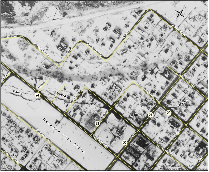
Figures
Figure 1. Overview map showing epicenter of the 1964 Great Alaska Earthquake (red star), the area on the
megathrust contact that ruptured (red polygon), and lines enclosing areas of similar Modified Mercalli Intensity
(Roman Numerals; Stover and Coffman, 1993), Alaska ................................................................................................ 2
Figure 2. Overview map (A) of Anchorage, Alaska, showing locations of photographic tour stops and boundaries
of three larger scale maps (B, C, and D) ....................................................................................................................... 3
Figure 3. The 5th Avenue Chrysler Building, Anchorage, Alaska, 1964........................................................................ 7
Figure 4. The Alaska Sales and Service Building, Anchorage, Alaska, 1964 ............................................................... 8
Figure 5. Fuel tank damaged by compressional folding at the toe of the Native Hospital Slide,
Anchorage, Alaska, 1964............................................................................................................................................... 9
Figure 6. Oblique aerial view looking south of the Native Hospital Slide and the former Alaska Native
Service Hospital , Anchorage, Alaska, 1964 ................................................................................................................ 10
Figure 7. Re-creation of the view south of the Native Hospital Slide and the former Alaska Native Service
Hospital from satellite imagery and 2011 lidar elevation data, Anchorage, Alaska ...................................................... 11
Figure 8. Annotated March 30, 1964, aerial photograph of the Government Hill Slide, Anchorage, Alaska, 1964...... 12
Figure 9. Comparison photographs taken from the same location at the Government Hill Slide area, Anchorage,
Alaska, in 1964 (top) and 2013 (bottom) looking west near the middle of the uppermost occurrence of the word
“graben” in figure 8 ...................................................................................................................................................... 13
Figure 10. Damage to the McKinley Tower (Mount McKinley Building at the time of the earthquake), Anchorage,
Alaska, 1964. Compare the x-shaped cracks below the windows with those on the Inlet Tower (Stop 19) ................. 14
Figure 11. View looking southwest from 1st Avenue of warehouses damaged by compressional deformation
at the toe of the 4th Avenue Slide, Anchorage, Alaska, 1964 ...................................................................................... 15
Figure 12. Anchorage municipal wharf area at low tide, shortly after the earthquake, Anchorage, Alaska, 1964 ....... 16
Figure 13. View looking north from Buttress Park of the Port Access Bridge (photograph from Yang, 2006, p. 4),
Anchorage, Alaska....................................................................................................................................................... 17
Figure 14. Comparison photographs taken from the same location on 4th Avenue about 1 block east of the
main area of damage, Anchorage, Alaska. In 1964 (top), the ground just to the left of the sidewalk dropped
about 8 feet bringing the marquee of the Denali Theater down to street-level ............................................................. 18
Figure 15. Comparison photographs taken from the same location on 4th Avenue near the intersection
with C Street and looking west. Red arrows point to the west wall of the Army Navy store in both images ................. 19
Figure 16. Comparison photographs taken from the same location on 4th Avenue looking east through the
intersection with C Street, Anchorage, Alaska. Red arrows point to the McKinley Tower (Stop 6) in both images ...... 20
Figure 17. Figure 4 from Long and George (1966), showing cross-section views of the 4th Avenue Slide and
the post-earthquake design of the stabilizing gravel buttress ...................................................................................... 21
Figure 18. Comparison photographs of the J.C. Penney Building from D Street looking southwest,
Anchorage, Alaska....................................................................................................................................................... 22
Figure 19. Comparison photographs of the J.C. Penney Building from 5th Avenue looking west,
Anchorage, Alaska....................................................................................................................................................... 23
Figure 20. View looking east in late 1964 of the Westward Hotel ............................................................................... 24
Figure 22. Generalized cross-section view of the seven accelerometers in the Delaney Park
borehole array and the local stratigraphy (Delaney Park Alaska Digital Array, 2014) .................................................. 26
Figure 23. View looking northeast of the Hillside Apartment Building, Anchorage, Alaska ......................................... 27
Figure 24. Simplified diagram showing how the Nesbett Courthouse is meant to accommodate
ground motion below or beside the foundation without collapsing completely (Coffman Engineers, Inc., 1987) ......... 28

                                                                                     iv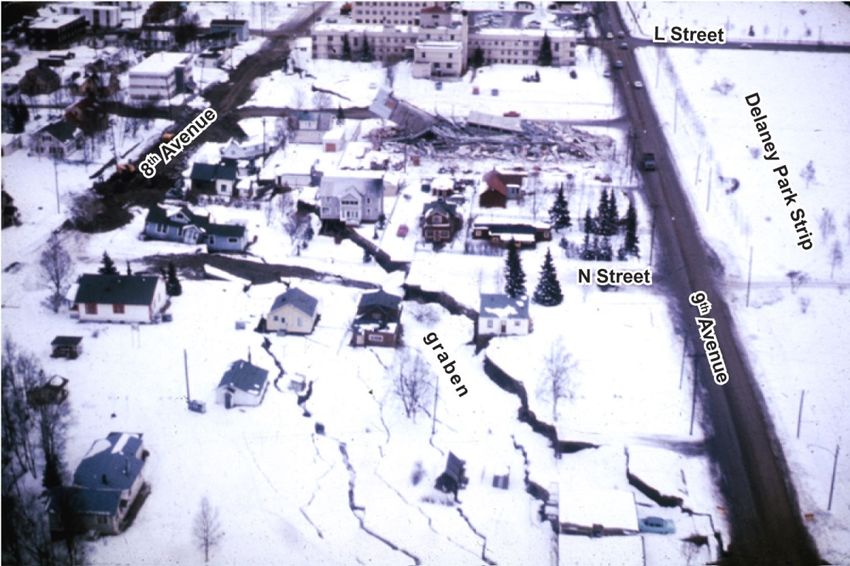
Figure 25. Detailed diagram of moment frame component within the Nesbett Courthouse
(McCool Carlson Green, 1993) .................................................................................................................................... 29
Figure 26. Detailed diagram of foundation mat and shear wall connection (McCool Carlson Green, 1993) .............. 30
Figure 27. Signs along a wall adjacent to a parking lot warn motorists and passersby about the hazard
presented by unreinforced masonry walls, Anchorage, Alaska.................................................................................... 31
Figure 28. Comparison photographs of the Inlet Tower taken from the same location on 13th Avenue ..................... 32
Figure 29. Annotated aerial photograph of most of the area affected by the L Street Slide, Anchorage, Alaska ........ 33
Figure 30. The apartment building behind the largely undamaged house in the foreground was sheared almost
equally in two when the western half dropped 7 feet down the main scarp at the head of the L Street Slide,
Anchorage, Alaska, 1964............................................................................................................................................. 34
Figure 31. View looking south down L Street from a just south of 6th Avenue, Anchorage, Alaska............................ 35
Figure 32. 1964 aerial photograph of St. Mary’s Residence and the nearby Four Seasons Apartment
Building (Stop 23), Anchorage, Alaska ........................................................................................................................ 36
Figure 33. The remains of the Four Seasons Apartment Building, Anchorage, Alaska, 1964 ..................................... 37
Figure 34. In this annotated view looking east, the graben at the head of the L Street Slide, Anchorage,
Alaska, 1964 cuts through properties between 8th and 9th Avenues from upper left to lower right ............................. 38
Figure 35. Annotated lidar-based hillshade elevation model of the probable landslide scar in the South Addition
neighborhood, Anchorage, Alaska ............................................................................................................................... 39
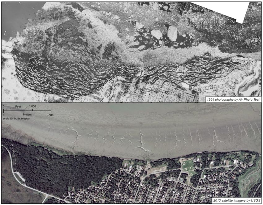
Figure 36. 1964 photo-mosaic showing the extent of the Turnagain Height Slide (top) and 2013 satellite imagery
(bottom) for comparison, Anchorage, Alaska ............................................................................................................... 40
Figure 37. View of part of the Turnagain Heights Slide looking roughly southeast shortly after the earthquake,
Anchorage, Alaska, 1964............................................................................................................................................. 41
Figure 38. View from within the Turnagain Heights Slide mass looking roughly south, Anchorage, Alaska, 1964..... 42
Figure 39. Tree split in half by a crack in frozen ground near in the Turnagain Heights Slide area,
Anchorage, Alaska, 1964............................................................................................................................................. 43
Figure 40. Part of a sand boil in the Turnagain Heights Slide area, Anchorage, Alaska, 1964 ................................... 44
Figure 41. Slip surface in the Bootlegger Cove Formation exposed near the west margin of the
Turnagain Heights Slide, Anchorage, Alaska. View is roughly to the west with Point Woronzof in the distance.......... 44
Figure 42. The destroyed control tower at the Anchorage International Airport, Anchorage, Alaska, 1964 ................ 45
v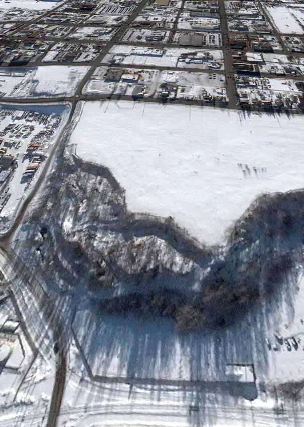
Conversion Factors and Datum
Conversion Factors
Inch/Pound to SI
                Multiply                               By                        To obtain
                                               Length

inch (in.)                                     2.54                  centimeter (cm)
inch (in.)                                    25.4                   millimeter (mm)
foot (ft)                                      0.3048                meter (m)
mile (mi)                                      1.609                 kilometer (km)
                                                Area
acre                                       4,047                     square meter (m2)
acre                                           0.4047                hectare (ha)
acre                                           0.4047                square hectometer (hm2)
acre                                           0.004047              square kilometer (km2)

Datum
Horizontal coordinate information is referenced to the North American Datum of 1983 (NAD 83).

                                                              vi
1964 Great Alaska Earthquake—A Photographic Tour of
Anchorage, Alaska
By Evan E. Thoms, Peter J. Haeussler, Rebecca C. Anderson, and Robert G. McGimsey

Introduction
        On March 27, 1964, at 5:36 p.m., a magnitude 9.2 earthquake, the largest recorded earthquake in
U.S. history, struck southcentral Alaska (fig. 1). The Great Alaska Earthquake (also known as the Good
Friday Earthquake) occurred at a pivotal time in the history of earth science, and helped lead to the
acceptance of plate tectonic theory (Cox, 1973; Brocher and others, 2014). All large subduction zone
earthquakes are understood through insights learned from the 1964 event, and observations and
interpretations of the earthquake have influenced the design of infrastructure and seismic monitoring
systems now in place. The earthquake caused extensive damage across the State, and triggered local
tsunamis that devastated the Alaskan towns of Whittier, Valdez, and Seward. In Anchorage, the main
cause of damage was ground shaking, which lasted approximately 4.5 minutes. Many buildings could
not withstand this motion and were damaged or collapsed even though their foundations remained
intact. More significantly, ground shaking triggered a number of landslides along coastal and drainage
valley bluffs underlain by the Bootlegger Cove Formation, a composite of facies containing variably
mixed gravel, sand, silt, and clay which were deposited over much of upper Cook Inlet during the Late
Pleistocene (Ulery and others, 1983). Cyclic (or strain) softening of the more sensitive clay facies
caused overlying blocks of soil to slide sideways along surfaces dipping by only a few degrees.
        This guide is the document version of an interactive web map that was created as part of the
commemoration events for the 50th anniversary of the 1964 Great Alaska Earthquake. It is accessible at
the U.S. Geological Survey (USGS) Alaska Science Center website:
http://alaska.usgs.gov/announcements/news/1964Earthquake/. The website features a map display with
suggested tour stops in Anchorage, historical photographs taken shortly after the earthquake, repeat
photography of selected sites, scanned documents, and small-scale maps, as well as links to slideshows
of additional photographs and Google Street View™ scenes. Buildings in Anchorage that were severely
damaged, sites of major landslides, and locations of post-earthquake engineering responses are
highlighted. The web map can be used online as a virtual tour or in a physical self-guided tour using a
web-enabled Global Positioning System (GPS) device. This publication serves the purpose of
committing most of the content of the web map to a single distributable document. As such, some of the
content differs from the online version.

                                                    1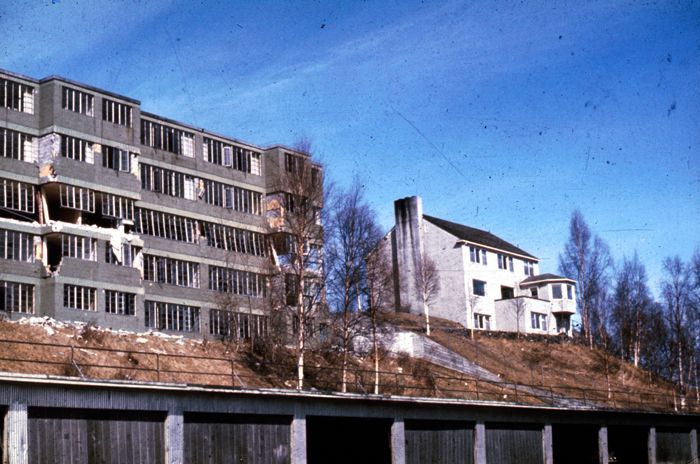
Figure 1. Overview map showing epicenter of the 1964 Great Alaska Earthquake (red star), the area on the
megathrust contact that ruptured (red polygon), and lines enclosing areas of similar Modified Mercalli Intensity
(Roman Numerals; Stover and Coffman, 1993), Alaska.
How to Use This Guide
The tour area only covers the City of Anchorage. An overview map (fig. 2) shows the three areas
covered by the tour with numbered icons for each tour stop described in the “Photographic Tour Stops”
section. For simplicity, the stops have been sorted from east to west, so the numbers do not imply the
order in which they should be visited, and directions to the stops are not given in this guide. Although
the map uses high-resolution and accurate base layers, it should not be used as the sole source of
navigation. Many of the stops are at locations where nearby parking is available or at public parks, but
some are on private land where businesses are operating. Please be considerate of their business; park
away from entrances and exits, make your visit short, and be polite if approached.
The stops are broadly organized into two groups: (1) sites where there was notable damage as a
result of the earthquake, and (2) sites that illustrate the post-earthquake response in terms of engineering
meant to reduce the potential for further damage or instrumentation that collects data used by scientists
and engineers to better understand seismic hazards. Many sites of historic damage show no present-day
(2013) evidence of the earthquake as most of the massive landslides have been re-graded and developed,
and some buildings that were damaged have been repaired whereas others have been removed for other
reasons.
Many of the images used in the guide can be accessed at the USGS Photographic Library (USGS
PL) website (http://libraryphoto.cr.usgs.gov/) on the Key Word Search page by searching for the
photograph identification (ID) given in figure captions (for example, USGS PL, ID aeq00025, search for
“aeq00025”). Tour stop and photograph descriptions come verbatim from Hansen (1965), photograph
captions accessed at the USGS Photographic Library, or modified from other sources.
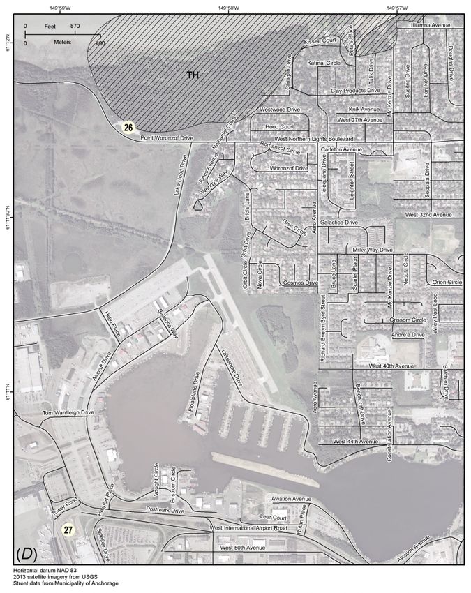
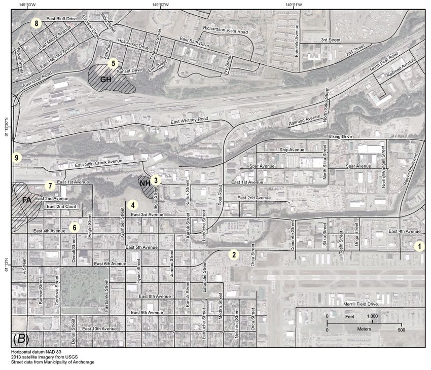
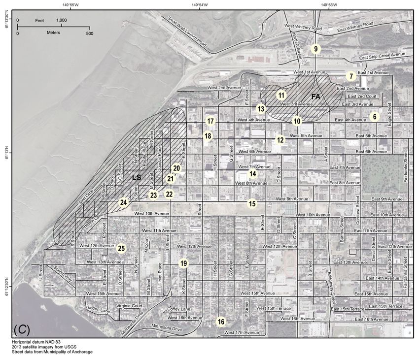
2Figure 2. Overview map (A) of Anchorage, Alaska, showing locations of photographic tour stops and boundaries of
three larger scale maps (B, C, and D).The larger scale maps include numbered icons that refer to tour stop
headings in the text where the sites are described and include the generalized extents of the more notable
landslides, shown with cross-hatching (generalized from Hansen [1965]). (FA, Fourth Avenue Slide; GH,
Government Hill Slide; LS, L Street Slide; NH, Native Hospital Slide; TH, Turnagain Heights Slide.)
3Figure 2.—Continued.
4Figure 2.—Continued.
5Figure 2.—Continued.
6Photographic Tour Stops
1. 5th Avenue Chrysler Building
“The one-story 5th Avenue Chrysler Center just north of Merrill Field was a total loss. It had a
precast- and prestressed-concrete T-beam roof supported by concrete-block walls. The front of the
building collapsed and the T-beam roof fell in on the showroom. The hollow-core concrete block side
walls failed at the rear corners of the building” (Hansen, 1965, p. A24) (fig. 3).
Figure 3. The 5th Avenue Chrysler Building, Anchorage, Alaska, 1964. (Photograph from U.S. Geological Survey
Photographic Library, ID aeq00025.)
72. Alaska Sales and Service Building
“The one-story Alaska Sales and Service Building on East 5th Avenue at Medfra Street was
under construction but was structurally almost complete at the time of the earthquake; it was a total loss.
Collapse is attributed chiefly to failure of melded connections between T-shaped precast-concrete
columns and roof beams, caused either by the breaking of welds or tearing out of bar inserts. The
exterior precast-concrete walls of the building partly collapsed when the roof gave way” (Hansen, 1965,
p. A23; fig. 4).
Figure 4. The Alaska Sales and Service Building, Anchorage, Alaska, 1964. (Photograph from U.S. Geological
Survey Photographic Library , ID aeq00024.)
83. Compressional Fold at Toe of Native Hospital Slide
Like a rug being pushed along a floor, landslides can cause folding of the ground in front of
them as they slide. A fuel tank (fig. 5) at the toe of the Native Hospital Slide (stop 4) was damaged by
this type of folding because of shortening when the bluff upslope failed and slid downhill (Hansen,
1965). Deformation like this also caused damage to buildings at the toes of the 4th Avenue and L Street
Slides (Hansen, 1965, p. A23).
Figure 5. Fuel tank damaged by compressional folding at the toe of the Native Hospital Slide, Anchorage, Alaska,
1964. Red arrow indicates the direction of push from the landslide and the dashed red line indicates the crest of the
resulting fold in the ground. (Photograph from U.S. Geological Survey Photographic Library, ID aeq00053.)
94. Native Hospital Slide
“The Native Hospital Slide, or 1st Avenue Slide as it has occasionally been called, disrupted part
of the grounds of the Alaska Native Service Hospital and wrecked a fuel-storage tank at the foot of the
bluff. Although it was a small slide and not a very destructive one, it was of unusual scientific interest
because of its clear portrayal of repeated translatory landsliding in the same area. The slide of March 27,
1964, transected an earlier slide of identical habit and exposed the older graben in full cross section in
the headward scarp of the present graben. This site of failure, therefore, seems to answer the question as
to whether natural remolding and consolidation of the clay after sliding is sufficient in itself to forestall
further sliding—it obviously was not, in the Native Hospital Slide. Most other slide areas at Anchorage
and vicinity also presented evidence of multiple sliding, but none did it as clearly as the Native Hospital
Slide” (Hansen, 1965, p. A49; fig. 6).
Figure 6. Oblique aerial view looking south of the Native Hospital Slide and the former Alaska Native Service
Hospital , Anchorage, Alaska, 1964. The damaged fuel tank from Stop 3 (fig. 5) can be seen below the middle of
the left margin of the photograph. (Photograph from U.S. Geological Survey Photographic Library, ID ake00065.)
10The hospital remained in service until the occupation of a new building in 1997 and was
demolished shortly thereafter (Rife and Dellapenna, 2009). The scars of both the 1964 landslide and the
undated landslide before 1964 are visible at the present day (2013) (fig. 7).
Figure 7. Re-creation of the view south of the Native Hospital Slide and the former Alaska Native Service Hospital
from satellite imagery and 2011 lidar elevation data, Anchorage, Alaska. (Satellite imagery from 2014, ©Digital
Globe, NextView License; 2011 lidar data from Federal Emergency Management Agency, project number
400000072.)
115. Government Hill Slide–Sunset Park
The Government Hill Elementary School was destroyed when part of the bluff on which it was
built slid southward about 35 feet toward Ship Creek and caused lowering of the ground in the form of
two major troughs, or grabens, and many smaller fractures (fig. 8; Hansen, 1965, p. A54). The surface
along where the sliding occurred was within a sensitive facies of the underlying Bootlegger Cove
Formation (Hansen, 1965, p. A58). Because school was not in session (the earthquake occurred in the
evening and March 27, 1964, fell on Good Friday, observed as a holiday in Alaska at the time) and the
building was empty, no lives were lost (Hansen, 1965). The school was rebuilt two blocks to the north
in 1965 and the former school site was developed into a park in 1985 (Municipality of Anchorage, 2013;
fig. 9).
Figure 8. Annotated March 30, 1964, aerial photograph of the Government Hill Slide, Anchorage, Alaska, 1964.
(Photograph taken by Air Photo Tech.)
12Figure 9. Comparison photographs taken from the same location at the Government Hill Slide area, Anchorage,
Alaska, in 1964 (top) and 2013 (bottom) looking west near the middle of the uppermost occurrence of the word
“graben” in figure 8. The same watertower is visible in the background of both images. (Top photograph from U.S.
Geological Survey Photographic Library, ID ake00067; bottom photograph taken by R.G. McGimsey, U.S.
Geological Survey, 2013.)
136. McKinley Tower
The McKinley Tower (historically known as the Mount McKinley Building and the MacKay
Building) and the Inlet Tower (historically known as the 1200 L Street Building) (Stop 19) are identical
14-story apartment buildings completed in 1951 about 1 mi apart. Both towers sustained similar
damage, the most obvious being classic x-shaped shear cracks in the exterior stucco below many of the
windows (fig. 10; Hansen, 1965, p. A26). During retrofitting, beginning in the late 1990s, structural
elements in the Mckinley Tower building were reinforced with an epoxy-saturated carbon fabric in
order help meet seismic building codes (Martin, 2005).
Figure 10. Damage to the McKinley Tower (Mount McKinley Building at the time of the earthquake), Anchorage,
Alaska, 1964. Compare the x-shaped cracks below the windows with those on the Inlet Tower (Stop 19).
(Photograph from Judith and Malcolm McDonald papers, Archives and Special Collections, Consortium Library,
University of Alaska Anchorage ID uaa-hmc-0619-s2-f22-20.)
147. Compressional Folding at Toe of 4th Avenue Slide
While tensional fractures and deep grabens characterized the 4th Avenue Slide between 2nd and
4th Avenue, warehouses along 1st Avenue were heavily damaged by compressional deformation at the
toe of the slide (Hansen, 1965, p. A23; fig. 11). This area remains an important distribution center for
goods, but the risk of damage similar to that incurred in 1964 is ostensibly reduced by the construction
of Buttress Park (Stop 11).
Figure 11. View looking southwest from 1st Avenue of warehouses damaged by compressional deformation at the
toe of the 4th Avenue Slide, Anchorage, Alaska, 1964. The Westward Hotel (Stop 13) can be seen in the
background. (Photograph from U.S. Geological Survey Photographic Library, ID aeq00051.)
158. Port of Anchorage Overlook–Suzan Nightingale McKay Park
“Much of the damage in the Port of Anchorage area was caused by ground displacements along
fractures, but some damage is attributable to direct seismic shaking. The main pier lurched laterally 5 to
19 inches. Large longitudinal cracks and several transverse ones opened up, and the walls of several
buildings were cracked. All four gantry cranes were damaged. Steel piles penetrated the deck of a
subordinate pier. Approach roads and railroads settled as much as 18 inches. Two cement-storage tanks
were toppled, one at the property of the Permanente Cement Co. at the entrance to the U.S. Army Dock
and one at the Alaska Aggregate Corp. facility just north of Ship Creek. Oil-storage tanks in the dock
area were mostly superficially damaged, but some tanks were bulged outward at the bottom, probably
by rocking and pounding back and forth as the contents sloshed to and fro” (Hansen, 1965, p. A27; fig.
12).
Figure 12. Anchorage municipal wharf area at low tide, shortly after the earthquake, Anchorage, Alaska, 1964. The
main dock was slightly damaged, but the older U.S. Army dock (upper left) was ruined. Vibration and ground
fractures damaged some structures in the port area, including the fuel tank seen in the lower right. (Photograph
from U.S. Geological Survey Photographic Library, ID ake00243.)
169. Instrumentation of the Port Access Bridge
In an effort to understand more about how bridges react to earthquakes, the Port Access Bridge,
constructed in 1975 and retrofitted through the years, was instrumented with accelerometers beginning
in 2003 (Yang and others, 2004; Yang, 2006). In all, 39 sensors along its length record earthquake- and
train-induced vibrations and collect data used by scientists and engineers (Yang, 2006).
Figure 13. View looking north from Buttress Park of the Port Access Bridge (photograph from Yang, 2006, p. 4),
Anchorage, Alaska. Accelerometers are installed near the tops of many of the support columns.
10. 4th Avenue Slide
“The 4th Avenue Slide involved all or parts of 14 city blocks in a roughly oval area of about 36
acres, containing perhaps 2 million cubic yards of earth, centered at the northern side of downtown
Anchorage. It was bounded headward on the south by 4th Avenue, on the west by E Street, on the north
approximately by 1st Avenue, and on the east somewhat indefinitely by Barrow Street. Its length north
to south in the direction of slippage was about 1,050 feet; east to west it was about 1,800 feet across.
Strong fracturing and related ground displacements extended 1-1/2 blocks (about 450 feet) or so south
of the slide proper, where considerable damage was inflicted on buildings, streets, and sidewalks. Minor
displacements extended as far south as 600 feet. Eyewitnesses reported that sliding began about 2
minutes after the earthquake started and stopped about the same time as the earthquake” (Hansen, 1965,
p. A41; figs. 14, 15, and 16).
17Figure 14. Comparison photographs taken from the same location on 4th Avenue about 1 block east of the main
area of damage, Anchorage, Alaska. In 1964 (top), the ground just to the left of the sidewalk dropped about 8 feet
bringing the marquee of the Denali Theater down to street-level. (Top photograph from U.S. Geological Survey
Photographic Library, ID aeq00046, 1964; bottom photograph taken by R.G. McGimsey, U.S. Geological Survey,
2013.)
18Figure 15. Comparison photographs taken from the same location on 4th Avenue near the intersection with
C Street and looking west. Red arrows point to the west wall of the Army Navy store in both images. (Top
photograph [1964] from U.S. Geological Survey Photographic Library, ID aeq00045; bottom photograph [2013]
taken by R.G. McGimsey, U.S. Geological Survey, 2013.)
19Figure 16. Comparison photographs taken from the same location on 4th Avenue looking east through the
intersection with C Street, Anchorage, Alaska. Red arrows point to the McKinley Tower (Stop 6) in both images.
(Top photograph [1964] taken by U.S. Army, U.S. Geological Survey Photographic Library, ID ake00144; bottom
photograph [2013] taken by R.G. McGimsey, U.S. Geological Survey.)
2011. Buttress Park
Much of the 4th Avenue Slide area north of 3rd Avenue has been re-graded since the earthquake
and turned into Buttress Park. The north-facing slope dropping into Ship Creek has been reinforced at
its toe with a buried gravel buttress, giving the park its name (fig. 17). Details of the design can be
found in Long and George (1966).
Immediately following the earthquake, 25 boreholes in and around a number of the major
Anchorage landslides were installed with slope-inclinometer casings. Measurements were taken
frequently through 1965, but rarely thereafter. All recoverable casings were resurveyed in 1979 and a
comparison was made between the old and new data. Updike (1983) reported that negligible strain had
occurred in the area of the L Street and Turnagain Heights Slides since the earthquake. There were,
however, three zones of up to 3 inches of deflection in the Buttress Park area of the 4th Avenue Slide.
The zones of strain have strong correlations with known weak layers in the Bootlegger Cove Formation
which were probably the zones of failure for the landslide. Nearly all of the strain apparently happened
before 1976, but Updike (1983) still expressed concern about the potential for movement in this area.
Figure 17. Figure 4 from Long and George (1966), showing cross-section views of the 4th Avenue Slide and the
post-earthquake design of the stabilizing gravel buttress. (Used with permission from American Society of Civil
Engineers.)
2112. J.C. Penny Store
At the time of the earthquake, the J.C. Penney store was five stories tall. The building was
damaged beyond repair and torn down (figs. 18 and 19). The principal cause of damage is attributed to
rotational motion of the foundation which caused the shearing of various support walls throughout the
building (Hansen, 1965, p. A26). At least one death occurred when the north wall of the building fell on
a parked car as the owner was attempting to move it to safety (Hansen, 1965, p. A27).
Figure 18. Comparison photographs of the J.C. Penney Building from D Street looking southwest, Anchorage,
Alaska. (Top photograph [1964] taken by George Plafker, U.S. Geological Survey Photographic Library, ID
ake00055; bottom photograph [2013] taken by R.G. McGimsey, U.S. Geological Survey.)
22Figure 19. Comparison photographs of the J.C. Penney Building from 5th Avenue looking west, Anchorage,
Alaska. (Top photograph [1964] taken by U.S. Geological Survey; bottom photograph [2013] taken by R.G.
McGimsey, U.S. Geological Survey.)
2313. Westward (Hilton) Hotel
There was little visible damage to the 14-story Westward Hotel, but damage to the interior
structural elements was severe (Hansen, 1965, p. A23; fig. 20). The building was repaired, expanded to
the west in the 1980s, and is now known as the Hilton Anchorage West Tower (Tundra Times, 1984).
Figure 20. View looking east in late 1964 of the Westward Hotel. The lower building in the foreground sits where
the Hilton Anchorage East Tower is presently located (2014). (Photograph from Alaska’s Digital Archives, Ward
Wells Collection, ID AMRC-wws-4231-1.)
2414. Robert Atwood Government Building
Through the direction of the Advanced National Seismic System (ANSS), seismometers were
installed throughout the 20-story Atwood Building in 2003 (fig. 21) to provide improved information
about how some buildings respond to earthquakes (Ҫelebi and others, 2004). The sensors record lateral
swaying, twisting, rocking, and drift (displacement) between floors. For comparison with ground
motion at sites unaffected by infrastructure, the array in the Atwood Building is complemented by the
Delaney Park borehole array two blocks south (Stop 15).
Figure 21. Schematic of the Atwood Building depicting the general locations of seismometers that have been
installed to record motion from seismicity (from Çelebi and others, 2004).
2515. Delaney Park Borehole Array
Seven accelerometers at Delaney Park, along with accelerometers installed throughout the
Atwood Building (Stop 14) two blocks to the north, make up one of the first monitoring systems of its
kind (Ҫelebi and others, 2004; Delaney Park Alaska Digital Array, 2014; fig. 22). The sensors have
been installed at depths between the surface and 200 feet, within the undisturbed glacial stratigraphy, to
give engineers detailed information on the interaction between the soil and infrastructure.
Figure 22. Generalized cross-section view of the seven accelerometers in the Delaney Park borehole array and the
local stratigraphy (Delaney Park Alaska Digital Array, 2014).
2616. Hillside Apartment Building
“The Hillside Apartments were on the south side of 16th Avenue between G and H Streets on a
bluff overlooking Chester Creek. They were damaged beyond repair and have since been dismantled.
This was a split-level building, five stories high on the south side and three stories high on the street
side. It had a post-and-lintel frame with steel-pipe columns, rolled-steel beams and concrete floor slabs
on steel joists. Walls were unreinforced hollow concrete block. The building was sheared in an east-
west direction at the third-story level on the south side and in the lower two stories on the north side—
the upper stories lurched west relative to the lower stories” (Hansen, 1965, p. A25–A26; fig. 23).
Although built on a bluff, there was no landsliding here; the building was damaged as a result of ground
shaking alone.
Figure 23. View looking northeast of the Hillside Apartment Building, Anchorage, Alaska. The adjacent white wood-
framed house received little damage and is standing at the present day (2014). (Photograph from U.S. Geological
Survey Photographic Library, ID aeq00021.)
2717. Nesbett Courthouse
The Nesbett Courthouse is a 6-story building designed according to the 1991 Uniform Building
Code and constructed in the mid-1990s. The site lies within Anchorage's Seismic Hazard Zone 4, which
means it has a “high” potential for earthquake-induced ground failure. The building was designed to fail
in a controlled way in order to accommodate ground displacements up to 4 feet horizontally and almost
3 feet vertically (fig. 24). The main structural support for the building is on steel beams, girders, and
columns bearing on a continuous 3-foot thick reinforced concrete slab foundation. Wind and seismic
forces (that is, lateral loads on the building) are resisted by a dual system of eccentric braced frames and
special moment frames. These lateral loads are transmitted to the slab foundation through concrete shear
walls in the basement. The predicted lateral and vertical displacements during a major earthquake-
induced landslide were designed to be taken up by rotation and deflection within unbraced sections of
the building frame, or “flexible bays,” in order to avoid complete collapse. Figures 25 and 26 are
examples of the structural and foundation details in the construction plans for this building.
Figure 24. Simplified diagram showing how the Nesbett Courthouse is meant to accommodate ground motion
below or beside the foundation without collapsing completely (Coffman Engineers, Inc., 1987). Unbraced “flexible
bays” are designed to take up displacements (DH = 4 feet, DV ≈ 3 feet) while allowing other sections of the building
to remain intact. Letters A-F are reference names for the sides of the frames in the building. DH and DV are the
vertical and horizontal, respectively, projected displacement due to landsliding.
28Figure 25. Detailed diagram of moment frame component within the Nesbett Courthouse (McCool Carlson Green,
1993).
29Figure 26. Detailed diagram of foundation mat and shear wall connection (McCool Carlson Green, 1993).
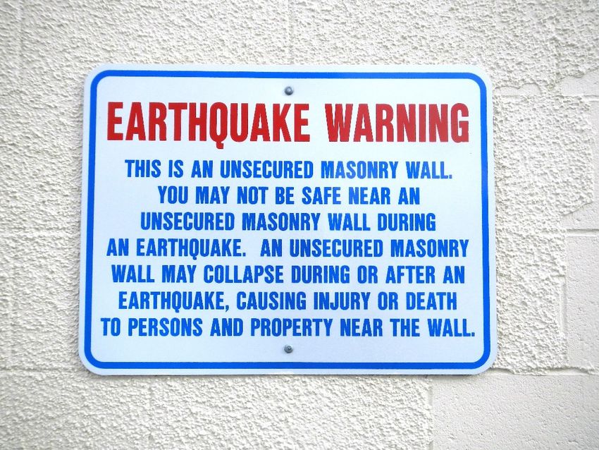
3018. Earthquake Warning Signs at Unreinforced Masonry Wall
Unreinforced masonry walls consist of brick, concrete block, or other masonry material that is
stacked and mortared without steel reinforcement, such as a grid of rebarthem. Although most
unreinforced masonry structures in Anchorage fared well during the earthquake (Hansen, 1965, p. A23),
they are of great concern worldwide because of the high rate of injury and property damage caused by
their collapse during earthquakes (Reitherman, 2009; fig. 27). Retrofitting of existing buildings,
however, is expensive and not required by most municipalities.
Figure 27. Signs along a wall adjacent to a parking lot warn motorists and passersby about the hazard presented
by unreinforced masonry walls, Anchorage, Alaska. (Photograph courtesy of Robert Scher, Anchorage
Geotechnical Advisory Commission [2013].)
3119. Inlet Tower
The Inlet Tower was moderately damaged because of ground shaking (fig. 28) in much the same
way as its twin, the McKinley Tower (Stop 6; Hansen, 1965, p. A26).
Figure 28. Comparison photographs of the Inlet Tower taken from the same location on 13th Avenue. (Left
photograph [1964] from U.S. Geological Survey Photographic Library, ID aeq00019; right photograph [2013] taken
by R.G. McGimsey, U. S. Geological Survey.)
3220. L Street Slide–715 L Street Apartment Building
Perhaps the most notable feature of the L Street Slide was the long arcuate graben that formed at
its head (fig. 29). It was concave toward the shoreline, about 3,600 feet long, with a maximum width of
about 250 feet (Hansen, 1965, p. A43). There were fractures on both sides of the graben and pressure
ridges at the toe of the slide which were damaging, but much of the slide mass showed little disturbance
despite moving toward the shoreline at distances of up to 14 feet (Hansen, 1965, p. A43). Much of the
damage occurred at the graben where the ground under foundations subsided as much as 10 feet
(Hansen, 1965, p. A43), as it did underneath the apartment building in figure 30.
Figure 29. Annotated aerial photograph of most of the area affected by the L Street Slide, Anchorage, Alaska.
Photographic tour stops are marked by number: (20) 715 L Street Apartment Building, (21) L Street Bend, (22) St.
Mary’s Residence, (23) Four Seasons Apartment Building, and (24) L Street Slide scarp. (Photograph taken by Air
Photo Tech, 1964.)
33Figure 30. The apartment building behind the largely undamaged house in the foreground was sheared almost
equally in two when the western half dropped 7 feet down the main scarp at the head of the L Street Slide,
Anchorage, Alaska, 1964. The apartments have been removed but the Anchorage Medical and Surgical Building to
the east was undamaged. (Photograph from U.S. Geological Survey Photographic Library, ID ake00327.)
3421. L Street Bend
The main scarp of the L Street Slide cut across L Street between 7th and 8th Avenues. Because
the slide mass west and north of the scarp moved seaward while the ground headward of the scarp
remained in place, the centerline of L Street now bends about 12 feet to the east, just south of 7th
Avenue (fig. 31).
Figure 31. View looking south down L Street from a just south of 6th Avenue, Anchorage, Alaska. The two subtle
but distinct kinks in the centerline, as it is traced from lower left toward the upper right, represent the re-alignment
of L Street where it crossed the main scarp at the head of the L Street Slide. (Photograph taken by Evan Thoms,
U.S. Geological Survey [2014].)
3522. St. Mary’s Residence – Old Providence Hospital
Completed in 1939, the original Providence Hospital became a nursing home known as St.
Mary’s Residence in 1962 and was a well-known landmark at the time of the earthquake. Despite its
proximity to the graben that formed at the head of the L Street Slide (fig. 32), the building survived the
earthquake with minimal damage and remained in use until it was demolished in the mid-1970s.
Figure 32. 1964 aerial photograph of St. Mary’s Residence and the nearby Four Seasons Apartment Building (Stop
23), Anchorage, Alaska. (Photograph taken by Air Photo Tech, 1964.)
3623. Four Seasons Apartment Building
The Four Seasons Apartment Building was a new 6-story lift-slab reinforced concrete building
nearing completion in 1964 (fig. 33). It reportedly withstood 2–3 minutes of shaking before collapsing
just before the end of the earthquake. The main shear-resistant structural elements of the building, a
poured-in-place reinforced concrete stairwell and a combined elevator shaft and stairwell, fractured at
the first floor, toppled over, and came to rest on top of building rubble, all the while remaining largely
intact (Hansen, 1965, p. A24–A25).
Figure 33. The remains of the Four Seasons Apartment Building, Anchorage, Alaska, 1964. The tilted column on
the right was the combined elevator shaft and stairwell. (Photograph from U.S. Geological Survey Photographic
Library, ID aeq00026.)
3724. Graben and Main Scarp at the Head of the L Street Slide
At this location, the graben at the head of the L Street Slide cut across 9th Avenue and continued
to the southwest across the Delaney Park Strip (fig. 34). The degraded main scarp is visible today as the
small rise in slope to the east between here and the Centennial Rose Garden.
Figure 34. In this annotated view looking east, the graben at the head of the L Street Slide, Anchorage, Alaska,
1964 cuts through properties between 8th and 9th Avenues from upper left to lower right. The collapsed Four
Seasons Apartment Building (Stop 23) and the relatively undamaged St. Mary’s Residence (Stop 22) lie beyond the
graben on undisturbed ground. The present-day Centennial Rose Garden is just off the right margin of this
photograph, near the N Street easement. (Photograph from U.S. Geological Survey Photographic Library, ID
aeq00043.)
3825. Pre-1964 Landslide Scarp at the Maxine and Frank Reed Family Staircase
The staircase at this stop (named in 2007 in honor of the philanthropic residents who lived at the
top of the staircase for more than 60 years) was built to accommodate pedestrian traffic over a steep
bluff that some (Hansen, 1965, p. A67; Schmoll and Dobrovolny, 1972) interpreted to be evidence of
landsliding during a pre-1964 earthquake of unknown age (fig. 35). Similar steep and arcuate bluffs
exist throughout the Anchorage area indicating that landsliding is a common process in this area. There
was no reported sliding on this feature in 1964 (Hansen, 1965, p. A67).
Figure 35. Annotated lidar-based hillshade elevation model of the probable landslide scar in the South Addition
neighborhood, Anchorage, Alaska. (2011 lidar data from Federal Emergency Management Agency, project number
400000072.)
26. Turnagain Heights Slide at Earthquake Park
The Turnagain Heights Slide occurred along a steep bluff fronting Knik Arm on Cook Inlet. Its
length east to west, parallel to the former shoreline, was about 1.5 miles, and the bluff retreated
southward a maximum of 1,200 feet into the Turnagain Heights neighborhood (fig. 36; Hansen, 1965 p.
A59). In all, about 130 acres were completely disrupted and 75 homes were reportedly destroyed
(Hansen, 1965, p. A59; figs. 36–41). Failure here and in the L Street, 4th Avenue, and Government Hill
landslides in Anchorage occurred on horizontal or near horizontal slip surfaces in a sensitive clay facies
of the underlying Bootlegger Cove Formation, prone to cyclic softening (Hansen, 1965, p. A65) . The
Tony Knowles Coastal Trail passes along the toe of the slide mass, where relics of the disturbed ground
surface are still visible near Earthquake Park, just north of the Ted Stevens Anchorage International
Airport.
39Figure 36. 1964 photo-mosaic showing the extent of the Turnagain Height Slide (top) and 2013 satellite imagery (bottom) for comparison,
Anchorage, Alaska. A portion of the area covered by the landslide has been turned into parks, but the rest remains residential in use. (Top
photograph taken by Air Photo Tech, 1964; bottom satellite imagery by U.S. Geological Survey, 2013.)
40Figure 37. View of part of the Turnagain Heights Slide looking roughly southeast shortly after the earthquake,
Anchorage, Alaska, 1964. (Photograph from U.S. Geological Survey Photographic Library, ID ake00087.)
41Figure 38. View from within the Turnagain Heights Slide mass looking roughly south, Anchorage, Alaska, 1964.
Note the structures on the new bluff in the background. The ground surface was lowered about 35 feet from the
pre-quake level. After the earthquake this area was regraded and gradually redeveloped with single-family
residences. (Photograph from U.S. Geological Survey Photographic Library, ID eib00337.)
42Figure 39. Tree split in half by a crack in frozen ground near in the Turnagain Heights Slide area, Anchorage,
Alaska, 1964. (Photograph from U.S. Geological Survey Photographic Library, ID ake00070.)
43Figure 40. Part of a sand boil in the Turnagain Heights Slide area, Anchorage, Alaska, 1964. Ridges 2–3 feet high
and 100 feet or more long were formed as fountains of water ejected through frozen ground. (Photograph from U.S.
Geological Survey Photographic Library, ID ake00060.)
Figure 41. Slip surface in the Bootlegger Cove Formation exposed near the west margin of the Turnagain Heights
Slide, Anchorage, Alaska. View is roughly to the west with Point Woronzof in the distance. (Photograph from
Hansen, 1965, fig. 43, p. A63).
4427. Anchorage International Airport Control Tower
The control tower at the Anchorage International Airport (now the Ted Stevens Anchorage
International Airport) collapsed because of ground shaking, killing one occupant (fig. 42) (Hansen,
1965, p. A23) . At seven stories high, this was the tallest structure in Anchorage that was completely
destroyed.
Figure 42. The destroyed control tower at the Anchorage International Airport, Anchorage, Alaska, 1964.
(Photograph from U.S. Geological Survey Photographic Library, ID aeq00027.)
Acknowledgments
This manuscript benefitted greatly from comments and suggestions from Robert Scher, Scott
Haefner, Robert Witter, Emily Roland, Yvette Gillies, and John Aho.
References Cited
Tundra Times, 1984, Bristol Bay to expand Westward Hilton: , Fairbanks, Alaska, March, 21, 1984, v.
21, no. 12.
Brocher, T.M., Filson, J.R., Fuis, G.S., Haeussler, P.J., Holzer, T.L., Plafker, G., and Blair, J.L., 2014,
The 1964 Great Alaska Earthquake and tsunamis—A modern perspective and enduring legacies: U.S.
Geological Survey Fact Sheet 2014–3018, 6 p., http://dx.doi.org/10.3133/fs20143018.
Cox, A., ed., 1973, Plate tectonics and geomagnetic reversals: San Francisco, W. H. Freeman and Co.,
702 p.
Ҫelebi, M., McCarthy, J., Biswas, N., Wald, L., Page, R., and Steidl, J., 2004, Seismic monitoring of the
Atwood Building in Anchorage, Alaska: U.S. Geological Survey Fact Sheet 2004-3103.
45Coffman Engineers, Inc., 1987, Anchorage courthouse expansion, Alaska Court System, State of
Alaska: Structural Design Narrative, Alaska Court System, State of Alaska, March 1987, various
pagination.
Delaney Park Alaska Digital Array, 2014, The George E. Brown Jr. network for earthquake engineering
simulation: NEES@UCSB, accessed April 8, 2014 at http://www.nees.ucsb.edu/dpk.
Hansen, W.R., 1965, Effects of the earthquake of March 27, 1964, at Anchorage, Alaska: U.S.
Geological Survey Professional Paper 542-A, p. A1–A68, 2 sheets, scale 1:480.
Long, E., and George, W., 1966, Buttress design earthquake-induced slides: Journal of the Soil
Mechanics and Foundations Division, Proceedings of the American Society of Civil Engineers, v. 93,
no. 4, July/August 1967, p. 595–609.
Martin, G.L., 2005, A new life for an old building—Once condemned, the old MacKay Building will
again stand tall with a new name and makeover: Alaska Business Monthly, October 1, 2005.
McCool Carlson Green, 1993, Anchorage courthouse expansion: Structural Bid Package, Project No.
4140001, Prepared for the Alaska Court System, Anchorage, Alaska.
Municipality of Anchorage, 2013, Anchorage original neighborhoods historic preservation plan:
Community Development Department–Planning Division, Page and Turnbull, BGES, Inc., Allied
GIS, AO 2013-12, 310 p., accessed April 1, 2014 at
http://www.muni.org/Departments/OCPD/Planning/Publications/Historic%20Preservation%20Plan/
00-Anchorage%20HPP-Complete.pdf.
Reitherman, R., 2009, Unreinforced masonry buildings and earthquakes: Developing Successful Risk
Reduction Programs, Federal Emergency Management Agency, FEMA P-774/October 2009, 47 p.,
accessed April 8, 2014 at http://www.fema.gov/media-library-data/20130726-1728-25045-
2959/femap774.pdf.
Rife, J.P., and Dellapenna, A.J., 2009, Caring and curing—A history of the Indian Health Service:
USPHS COF, 118 p., ISBN 978-0-9773149-2-8.
Schmoll, H.R., and Dobrovolny, E., 1972, Generalized geologic map of Anchorage and vicinity, Alaska:
U.S. Geological Survey Miscellaneous Geologic Investigations Map 787-A, 1 sheet, scale 1:24,000.
Stover, C.W., and Coffman, J.L., 1993, Seismicity of the United States, 1568-1989 (revised): U.S.
Geological Survey Professional Paper 1527, 418 p.
Ulery, C.A., Updike, R.G., and USGS Office of Earthquakes, 1983, Subsurface structure of the cohesive
facies of the Bootlegger Cove Formation, southwest Anchorage: Alaska Division of Geological &
Geophysical Surveys Professional Report 84, 5 p., 3 sheets, scale 1:15,840.
Updike, R.G., 1983, Inclinometer strain analyses of Anchorage landslides, 1965–1980: Alaska Division
of Geological & Geophysical Surveys Professional Report 80, 141 p.
Yang, J., 2006, Seismic response and structural health monitoring of the Port Access Viaduct in
Anchorage, Alaska: Presentation to Alaska Seismic Hazards Safety Commission, December 5, 2006,
accessed April 1, 2014 at
http://seismic.alaska.gov/download/ashsc_meetings_minutes/2006_12_05_Yang_MonitoringPortAcce
ssViaductAnc.pdf.
Yang, J., Liu, H., and Kono, T., 2004, Strong-motion instrumentation design of the Port Access Bridge,
Anchorage, Alaska: University of Alaska Anchorage, School of Engineering, accessed April 1, 2014,
at http://www.uaa.alaska.edu/schoolofengineering/research/upload/PortAccessBridge.pdf.
46Glossary
accelerometer A device that measures the change in acceleration, as opposed to displacement, of a
structure or device as a result of dynamic loads such as wind or earthquakes. The acceleration that is
measured can be thought of as what is commonly called g-force, felt during vibration, shock, or when
changing direction in a vehicle.
compressional stress The stress that squeezes something. It is the stress component perpendicular to a
given surface, such as a fault plane or a wall in a building.
concrete block A large, usually hollow, rectangular brick of concrete commonly used in construction.
cyclic (strain) softening The characteristic of cohesive soils (for example, clay and plastic silt) to
experience a reduction in shear strength and stiffness, sometimes significant, when subject to cyclic
straining.
earthquake Earthquake is a term used to describe both sudden slip on a fault, and the resulting ground
shaking and radiated seismic energy caused by the slip, or by volcanic or magmatic activity, or other
sudden stress changes in the Earth.
epicenter The epicenter is the point on the Earth’s surface vertically above the hypocenter (or focus);
point in the crust where a seismic rupture begins.
graben A graben is a down-dropped block of the Earth’s crust resulting from extension, or pulling, of
the crust.
ground motion Ground motion is the horizontal and vertical shaking, and rolling movement of the
earth's surface caused by the various forms of energy waves created from earthquakes or explosions.
inclinometer A device which measures the angle or the tilt relative to a vertical or horizontal datum.
Late Pleistocene The period in the Earth’s history from roughly 126,000 to 11,700 years ago
characterized as a time dominated by glaciation.
magnitude The magnitude is a number that characterizes the relative size of an earthquake. Magnitude
is based on measurement of the maximum motion recorded by a seismometer. Several scales have been
defined, but the most commonly used are: (1) local magnitude (ML), commonly referred to as "Richter
magnitude:" (2) surface-wave magnitude (Ms): (3) body-wave magnitude (Mb): and (4) moment
magnitude (Mw). Scales 1–3 have limited range and applicability and do not satisfactorily measure the
size of the largest earthquakes. The moment magnitude (Mw) scale, based on the concept of seismic
moment, is uniformly applicable to all sizes of earthquakes but is more difficult to compute than the
other types. All magnitude scales should yield approximately the same value for any given earthquake.
Modified Mercalli Intensity Scale The intensity is a number (written as a Roman numeral) describing the
severity of an earthquake in terms of its perceived effects on the Earth's surface and on humans and their
structures. Several scales exist, but the ones most commonly used in the United States are the Modified
Mercalli scale and the Rossi-Forel scale. The intensity value varies depending upon the number of
people who feel the event, the age of the building and type of construction, the surficial geology at the
site, as well as with distance from the earthquake rupture. In contrast, a magnitude is unique to the same
earthquake, regardless of distance.
subduction zone The subduction zone is the place where two lithospheric plates come together, one
riding over the other. Most volcanoes on land occur parallel to and inland from the boundary between
the two plates.
tectonic plates The large, thin, relatively rigid plates that move relative to one another on the outer
surface of the Earth.
tsunami A sea wave of local or distant origin that results from large-scale seafloor displacements
associated with large earthquakes, major submarine slides, or exploding volcanic islands.
landslide A movement of surface material down a slope.
47You can also read