International Charter Space and Major Disasters' Satellite-based support for disasters worldwide
←
→
Page content transcription
If your browser does not render page correctly, please read the page content below

International Charter
                ‚Space and Major Disasters‘

 Satellite-based support for disasters worldwide

               Jens Danzeglocke (German Space Agency at DLR)
      UN-SPIDER / ZFL Regional Virtual Expert Meeting for Southern Africa:
“Space-based Solutions for Disaster Risk Management and Emergency Response”,
                                13-15 July 2021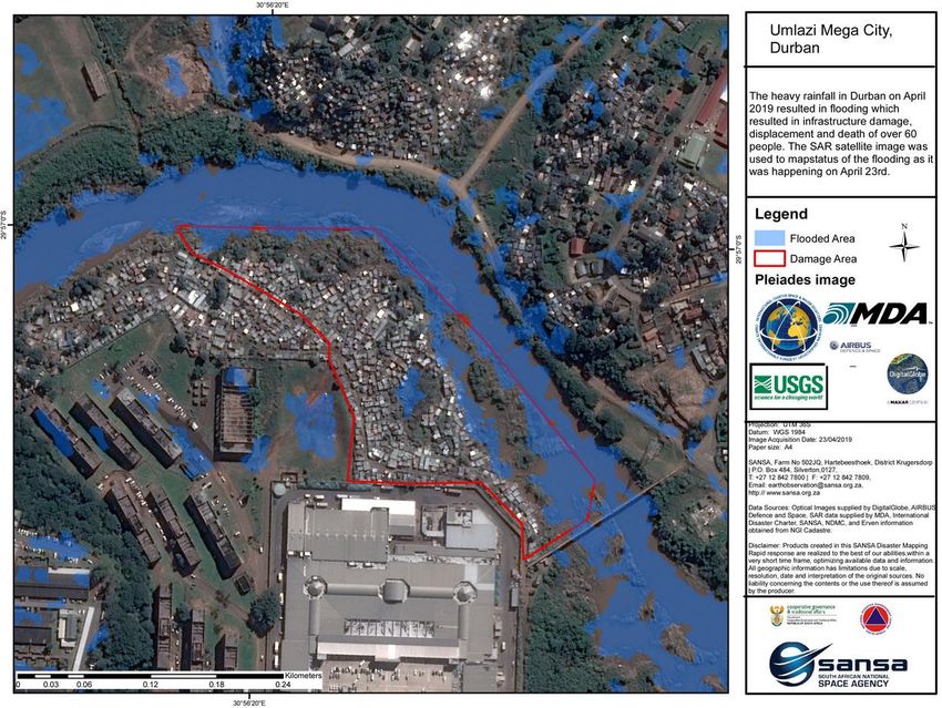
History

Following UNISPACE III in 1999, the International Charter ‘Space and
Major Disasters’ was established by the Space Agencies of Europe
(ESA), France (CNES), and Canada (CSA).

Charter became operational in Nov. 2000

                                                            © ESA–S. Corvaja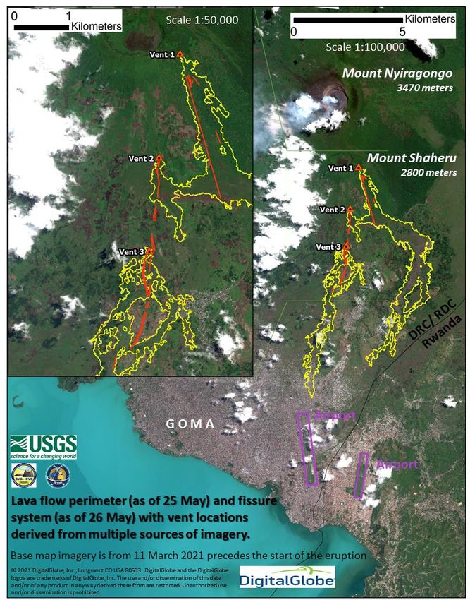
Purpose and scope

The Charter supports with space-based data and information emergency response
after major disasters, such as
• Sudden natural events: floods, storms, landslides, fires, earthquakes, volcanic
    eruptions etc.
• Man-made events: large industrial accidents and oil spills

The Charter does not cover emergencies caused by armed conflicts.

The Charter is available 24/7. When activated it executes priority tasking of
numerous Earth-observing satellite missions in a rapid fashion and provides
images and/or derived products.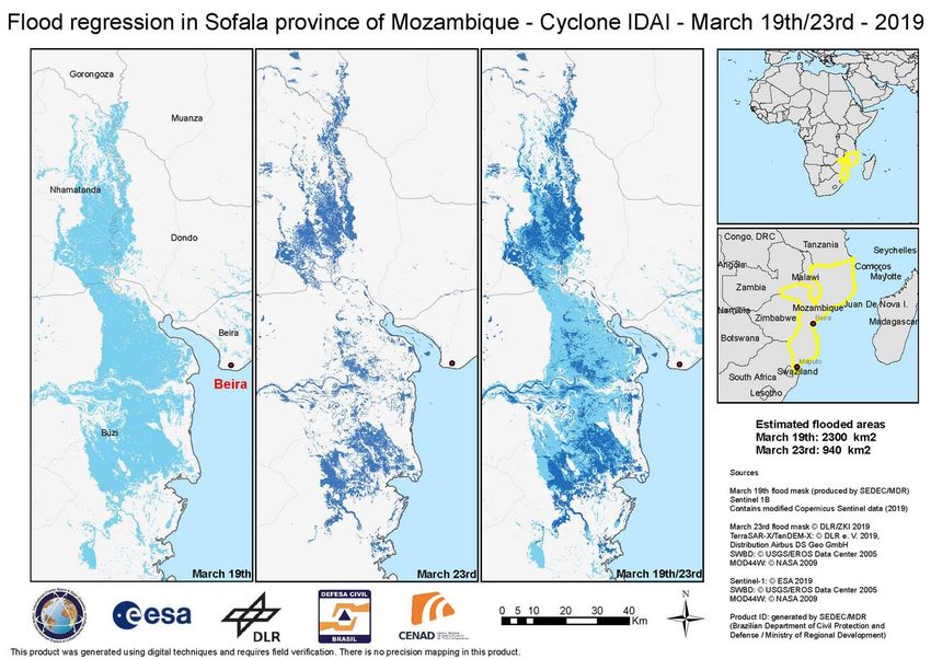
Membership

                       UKSA/DMC                ROSCOSMOS
 CSA                                DLR
                          UK                     Russia
Canada                            Germany
                        CNES     ESA
  NOAA                 France EUMETSAT
  USGS                                                                       JAXA
                               Europe                       CNSA
   USA                                                              KARI    Japan
                                                            China   Korea
                                            UAESA
                                             UAE    ISRO
                                                    India

           ABAE
         Venezuela

              INPE
              Brazil

          CONAE
         Argentina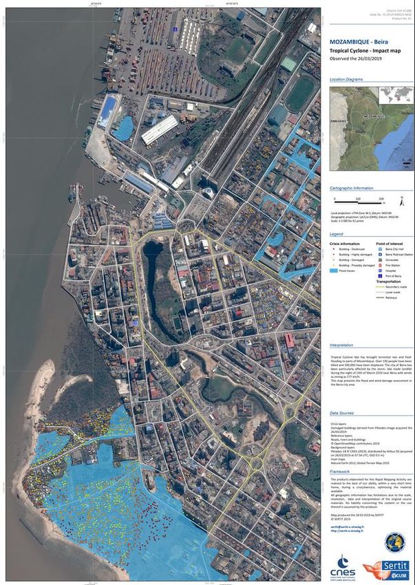
Activation Statistics

          Activation statistics as of 15 Oct. 2020
Distribution of Charter activations:
Support to disaster response in more than 120 countries

                                   October 15, 2020 – 680 Charter Activations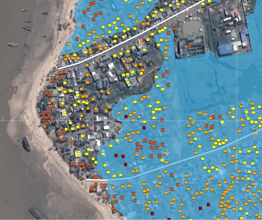
How the web-based of the Charter Operational System
          (“COS-2”) supports activations

                                     COS-2 provides a lot of
                                     information for the Project
                                     Manager and Value Adders
                                     in one place, e.g.:
                                     - Contact Information
                                     - Data acquisitions
                                         planned by Charter
                                         agencies
                                     - Available image data
                                         (metadata, quick looks,
                                         full data)
                                     - Areas of Interest
                                     - Derived products (maps)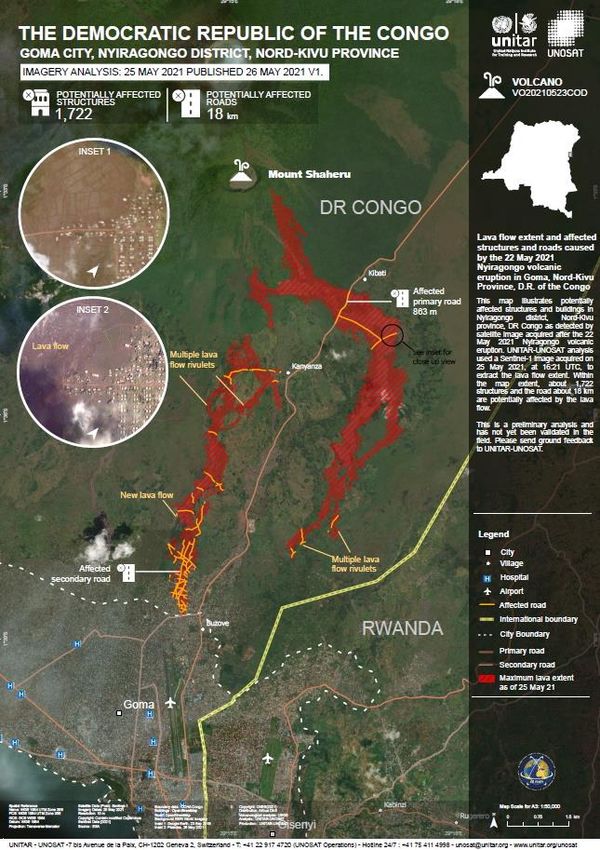
Further Evolution: Charter Processing
          Environment

The Charter Board approved the implementation of a Charter Processing
Environment proposed by ESA. The Processing Environment:
➢ aims to support Charter Project Managers and Value-Adding
   providers with on-line processing services during the activations.
➢ currently in pre-operational phase

                                                      The Geobrowser of the
                                                      Charter Processing
                                                      Environment, looking
                                                      at optical datasets over
                                                      a Charter activation in
                                                      Indonesia.
Authorized Users in >70 countries

The Charter works with Authorized Users – these entities
are able to directly trigger a Charter activation.

Authorized Users in >70 countries

In addition, there are agreements with entities allowed to
use/trigger the Charter in certain cases:
UNOOSA, UNITAR/UNOSAT, ADRC (Sentinel Asia),
EC-ERCC / Copernicus Emergency Management Service
Universal Access

Any national disaster management authority can become a Charter User!

The following conditions apply:
•   The entity must be a national disaster management authority or its delegated agency in
    that country.

•   It must have the capacity to download and use maps.

•   It must be able to submit and pursue an activation request in English.

An official letter of the organisation and a filled Registration Form (available at
https://disasterscharter.org) needs to be sent to ExecutiveSecretariat@disasterscharter.org .

Becoming an Authorized User does not happen from one day to the next, but
involves an assessment by the Charter members as well as a training and
simulation exercise.
Examples: Malawi
Malawi’s Department of Disaster Management Affairs
became an Authorized User in 2014.
It activated the Charter in 2015 due to major flooding
impacting half of the country.
Left: map based on RADARSAT-2 and LANDSAT imageryExamples: Mozambique
Cyclone Idai brought torrential rain and flooding to Mozambique in March 2019. The
Charter received activation requests from CENAD and UNOSAT
Map produced by
SEDEC/MDR based
on Sentinel-1 and
TerraSAR-X imageryExamples:
Mozambique
Several Value-adders contributed to the
provision of maps for this Charter
activation.
Map produced by SERTIT based on Pleiades very-high
resolution imageryExamples: South Africa
Floods and mudslides in Durban and the surrounding KwaZulu-Natal province of South Africa
have killed over 60 people and displaced more than 1000 in April 2019. Charter was activated
by UNOOSA on behalf of the National Disaster Management Centre of South Africa.
Map produced by
SANSA based on
Pleiades imageryExamples:
DR Congo
Eruptions of Mount Nyiragongo in May 2021.
Maps produced by USGS and UNITAR/UNOSATConclusions / Societal benefit achieved by the Charter
• The International Charter Space and Major Disasters is a rush-mode mechanism
supporting emergency response by providing quick access to satellite data and/or
derived products – with the intention to help save lives, property, infrastructure, and
the environment in cases of major disasters worldwide.
• The Charter has covered >700 emergencies caused by disasters in >120 countries.
• Universal Access encourages disaster management authorities from all countries to
become Authorised Users after training.
• The Charter encourages in-country capacities to act as “Project Managers” and “Value
Adders” (producers of satellite-based maps)
• In fruitful collaboration with UNOOSA/UN-SPIDER, UNITAR/UNOSAT, Sentinel Asia, and
the Copernicus Emergency Management Service, the Charter intends to help filling the
gap between space-faring and space-emerging nations.Find the Charter at
https://disasterscharter.org
https://twitter.com/disastersChart
How the Charter works and how users can benefit (5min Video):
https://www.youtube.com/watch?v=ZvExM-Z3E2w
xx-xx-xxxx Name SurnameYou can also read