It's Our Fault: Better Defining Earthquake Risk in Wellington
←
→
Page content transcription
If your browser does not render page correctly, please read the page content below
Submitted to: 11th IAEG Congress, Auckland
                                                                 Date submitted 1 February, 2010

It’s Our Fault: Better Defining Earthquake Risk in Wellington
R. Van Dissen1, P. Barnes2, J. Beavan1, J. Cousins1, G. Dellow1, C. Francois-Holden1,
B. Fry1, R. Langridge1, N. Litchfield1, T. Little3, G. McVerry1, D. Ninis3, D. Rhoades1,
R. Robinson1, W. Saunders1, P. Villamor1, K. Wilson1, P. Barker1, K. Berryman1, R.
Benites1, H. Brackley1, B. Bradley1, R. Carne3, U. Cochran1, M. Hemphill-Haley4, A.
King1, G. Lamarche2, N. Palmer1, N. Perrin1, N. Pondard2, M. Rattenbury1, S. Read1, S.
Semmens5, E. Smith3, B. Stephenson1, L. Wallace1, T. Webb1 & J. Zhao1
1
  GNS Science, Wellington, New Zealand
2
  NIWA, Wellington, New Zealand
3
  Victoria University of Wellington, Wellington, New Zealand
4
  Humboldt State University, California, USA
5
  University of Canterbury, Christchurch, New Zealand

ABSTRACT: The goal of the It’s Our Fault programme is to see Wellington positioned to be-
come a more resilient city through a comprehensive study of the likelihood of large Wellington
earthquakes, the effects of these earthquakes, and their impacts on humans and the built envi-
ronment. Some key results to date include better definition and constraint on: 1) faulting in
Cook Strait, 2) timing and size of past ruptures on the Wellington, Wairarapa, Wairau, and
Ohariu faults, 3) state of locking of the subduction interface, 4) fault interactions throughout the
region, in particular rupture statistics of the Wellington-Wairarapa fault-pair, and 5) conditional
probability of rupture of the Wellington Fault. Current investigations are focused on characteri-
sation of earthquake ground shaking behaviour in Wellington City and the Hutt Valley.

1 INTRODUCTION

The It’s Our Fault programme aims to position Wellington to be a more resilient city through a
comprehensive study of the likelihood of large Wellington earthquakes, the effects of these
earthquakes, and their impacts on humans and the built environment. It’s Our Fault is jointly
funded by New Zealand’s Earthquake Commission, Accident Compensation Corporation, Wel-
lington City Council, Wellington Region Emergency Management Group, and Greater Welling-
ton Regional Council. The programme comprises four main phases - Likelihood, Size, Effects
and Impacts (Table 1), is currently in its fourth year of funding, and will be implemented over a
seven year period.
   Work completed to date has largely focused on the Likelihood Phase which encompasses
four themes (Table 1): 1) geological investigations to better constrain the location and rate of
movement of major Wellington region faults, to extend the known sequence of surface rupture
earthquakes, and to investigate evidence for large subduction thrust earthquakes; 2) GPS studies
of the Wellington region to constrain the extent of the currently locked portion of the subduction
thrust under Wellington; 3) synthetic seismicity modelling of the Wellington region to investi-
gate the stress interactions of the major faults, and to specifically assess the rupture statistics and
interactions of the Wellington-Wairarapa fault-pair; 4) evaluation of the conditional probability
of rupture of the Wellington Fault. This paper presents a summary of some key results from
these investigations, and an outline of the work plan for the Effects Phase currently underway.

2 LIKELIHOOD PHASE RESULTS

2.1 Cook Strait fault mapping
A major initiative of the Likelihood Phase has been the detailed mapping of active faults in
Cook Strait (Figure 1) (Barnes et al. 2008, Barnes & Pondard in prep, Pondard et al. in prep).
This mapping, based on multi-beam bathymetry, high-resolution (boomer) and multi-channel
seismic reflection data, has illuminated critical relationships between the Marlborough fault sys-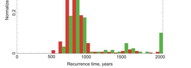
tem in the South Island, the strike-slip faults through the Wellington region, and the southern
Hikurangi subduction margin. In combination with onshore active fault data, the new Cook
Strait fault mapping has allowed a much more complete and consistent picture to be formulated
of the tectonic deformation, kinematics, and earthquake hazard of central New Zealand.

Figure 1. Active faults of central New Zealand (after Figure 7 of Barnes et al. 2008). Offshore faults from
Barnes et al. (2008) and Pondard et al. (in prep); onshore faults from GNS Science’s Active Faults Data-
base. Specific study sites mentioned in text are: CC, Cross Creek; K, Kaitoke; PB, Pigeon Bush; RL, Riv-
erslea; TK, Te Kopahou/Long Gully; TM, Te Marua/Emerald Hill.

   One of the most significant findings of this work is that there is a general discontinuity be-
tween the major faults of the North and South Islands. This has important implications for esti-
mating the size of active fault earthquake sources in the region, and understanding the patterns
of regional strain release and accumulation. Another important outcome is that paleoearthquake
records have been derived for three offshore faults in Cloudy Bay. Six paleoearthquake ruptures
are inferred on the offshore Wairau Fault since ~12,000 yrs BP (years before present) yielding
an average recurrence interval of ~2000 years, but with significant variability in inter-event du-
ration. Four to five earthquakes are recognised on the Vernon Fault since ~18,000 yrs BP, and
five events on the Cloudy Fault since ~17,000 yrs BP.

2.2 Wellington Fault

2.2.1 Timing of past ruptures
As part of It’s Our Fault, eight paleoearthquake trenches were excavated and logged, and ~30
radiocarbon samples dated at three sites along the Wellington-Hutt Valley segment of the Wel-
lington Fault (Te Kopahou/Long Gully, Te Marua and Kaitoke: Figure 1)(Langridge et al. 2009,
in prep). Results from these trenches, in combination with results from alluvial terrace dating
and offset investigations at Te Marua and Emerald Hill (Little et al. 2010, Ninis et al. 2010) and
previous trenching results (e.g. Van Dissen & Berryman 1996), constrain the timing of the last
five surface ruptures of the fault as follows (Langridge et al. 2009, in prep):
   Most recent rupture – There has been no rupture of the Wellington-Hutt Valley segment
within the time of European settlement of the region (i.e. since ~AD 1840). Two sites along the
Submitted to: 11th IAEG Congress, Auckland
                                                                       Date submitted 1 February, 2010

segment provide maximum constraints on the timing of the most recent rupture. At Te Kopa-
hou/Long Gully the most recent rupture is ≤450 yrs BP, and at Te Marua it is ≤310 yrs BP. Ac-
cordingly, the best estimate for the timing of the most recent rupture of the Wellington-Hutt
Valley segment is younger than 310 yrs BP and older than European settlement (170 yrs BP).
   Event II – There are a number of sites along the Wellington-Hutt Valley segment that provide
meaningful constraints as to the timing of Event II: Te Kopahou/Long Gully (790-930 yrs BP),
Te Marua (>675 yrs BP), Kaitoke (730-900 yrs BP). Taken collectively, the best estimate for
the timing of Event II is 790-900 yrs BP.
   Event III – The best constraint for the timing of Event III is 1830-2340 yrs BP from the Te
Kopahou/Long Gully area.
   Event IV – The timing of Event IV can be broadly constrained as having a minimum age of
2460 yrs BP (Te Kopahou/Long Gully) and a maximum age of ~4900 yrs BP (Te Marua).
   Event V – Though more interpretive in nature, the timing of Event V can be inferred at two
sites: Emerald Hill (
related to the most recent surface rupture of the Wellington-Hutt Valley segment and also the progressive displacements resulting from the last several surface rupture earthquakes. GPS-derived microtopographical maps were made of the young terrace offsets at Te Marua, and those at nearby Harcourt Park (Little et al. 2010). From these maps, 13 dextral offsets of ter- race risers and paleochannels were measured. These offsets range from ~5 m to ~20 m, and ap- pear to fall into four modes which are inferred to record slip accumulation during the last four surface rupture earthquakes on the fault. Based on this assumption, a mean single-event slip of 5.0 ± 1.5 m (1σ) is calculated. The corresponding coefficient of variation of single-event slip (0.3) for the Wellington Fault near Te Marua is slightly lower than the global average (Hecker & Abrahamson 2002), suggesting that the southernmost Wellington Fault has behaved in a more nearly characteristic way. 2.2.3 Conditional probability of rupture A primary goal of the Likelihood Phase of It’s Our Fault was a re-evaluation of the conditional probability of rupture of the Wellington-Hutt Valley segment of the Wellington Fault incorpo- rating new It’s Our Fault Wellington Fault data. Specifically, new estimates of: 1) timing of most recent rupture, and the previous four older ruptures (Langridge et al. 2009, in prep – see section 2.2.1 above); 2) size of single-event displacements (Little et al. 2010 – see section 2.2.2 above); 3) Holocene dextral slip-rate (Ninis et al. 2010); and 4) rupture statistics of the Welling- ton-Wairarapa fault-pair, as deduced from synthetic seismicity modeling (Robinson et al 2009 – see section 2.5 below). The methodology used is that of Rhoades et al. (1994, 2004) and Rhoades & Van Dissen (2003) which allows probability of rupture to be expressed as a single value that accounts for both data and parameter uncertainties. Four recurrence-time models were explored (Exponential, Lognormal, Weibull, Brownian Passage Time), and sensitivity runs were conducted entertaining different bounds and shapes of the probability distributions of important fault rupture data and parameters. Important findings (Rhoades et al. 2010a, 2010b, in review) include: 1) The estimated prob- ability of rupture in the next 100 years is ~10% (with sensitivity results ranging from ~4% to 15%), and the probability of rupture in the next 50 years is about half that (~5%); 2) In all cases, the inclusion of the new It’s Our Fault data has reduced the estimated probability of rupture of the Wellington Fault by ~50%, or more, compared to pre-It’s Our Fault estimates (Figure 2). Figure 2. Schematic representation, using a Russian roulette analogy, of the 100 year conditional prob- ability of rupture of the Wellington-Hutt Valley segment of the Wellington Fault. A) Prior to It’s Our Fault, probability was estimated to be about 30% (Rhoades et al. 2004). B) Current estimate, incorporat- ing new It’s Our Fault results, is about 10% (Rhoades et al. 2010a, 2010b, in review). 2.3 Wairarapa Fault To further refine the rupture chronology of the Wairarapa Fault, and test the completeness of the earthquake history derived for the fault from proxy records such as uplifted beach ridges at
Submitted to: 11th IAEG Congress, Auckland
Date submitted 1 February, 2010
Turakirae Head (McSaveney et al. 2006) and lake disturbances in Lake Kohangapiripiri (Coch-
ran et al. 2007), four trenches were excavated in a small pull-apart graben along the Wairarapa
Fault near Cross Creek (two across each bounding fault), two trenches were excavated at River-
slea, two at Pigeon Bush, and over 40 radiocarbon samples were dated (Little et al. 2009). Five
surface rupturing events since ~5500 yrs BP are recorded by deformed peat layers and variably
faulted and deformed colluvial wedges exposed in the trenches. Three of the events coincide
with the timing of Turakirae Head uplift events, the youngest of which is AD 1855. The older
two Turakirae-equivalent earthquakes were dated in the trenches at 1940-2340 yrs BP and 4620-
5280 yrs BP. Two events resolved in the trenches are additional to the Turakirae-expressed
ones. The preferred ages of these “extra” events are 3070-3690 yrs BP and 800-920 yrs BP.
These results indicate that the southern Wairarapa Fault has ruptured with a mean recurrence of
~1200 years since ~5500 yrs BP.
2.4 Geodetic & GPS studies
The velocities of survey marks measured by GPS in the Wellington region provide insight into
the state of interseismic coupling on the subduction interface, and the rate of fault slip on major
crustal faults in the lower North Island. As part of It’s Our Fault, the Wellington region GPS
network was re-surveyed in 2007 (Beavan & Wallace 2008). These data, together with earlier
campaign GPS data collected in the southern North Island and northern South Island, along with
onshore and offshore fault slip rate and location data were used to produce an updated version
of the Wallace et al. (2004) model for subduction coupling and crustal block rotations. In the
model, the kinematic data (e.g. GPS velocities, fault slip rates) are inverted simultaneously for
poles of rotation of tectonic blocks and the degree of interseismic coupling on faults in the re-
gion, including the subduction interface. This endeavour has been greatly facilitated by the It’s
Our Fault-catalysed advances in the characterisation of offshore faulting in Cook Strait, and im-
proved constraints on the behaviour of the onshore faults.
The new model (Wallace et al. in prep) achieves an excellent fit to offshore and onshore fault
slip rates and the geodetic data, and provides a geologically and geodetically consistent interpre-
tation of predicted slip distribution within the plate boundary zone of central New Zealand. Im-
portantly, the new model gives the best image to date of the contemporary state of interseismic
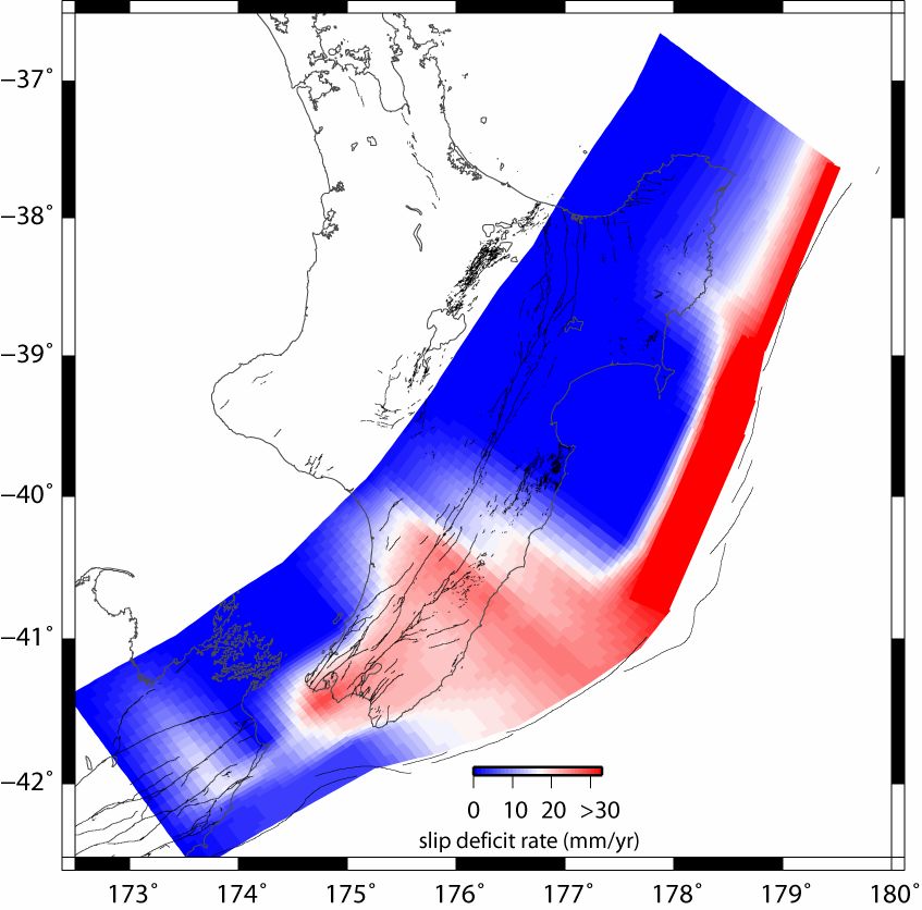
coupling on the subduction interface and provides constraints on the size of potential source ar-
eas for future subduction thrust events (Figure 3).
2.5 Synthetic seismicity
A synthetic seismicity computer model of multiple, interacting faults has been constructed and
used to investigate temporal earthquake clustering (and shadowing) in central New Zealand, en-
compassing SE Marlborough, Cook Strait, Wellington, and southern onshore and offshore
Wairarapa regions (Robinson et al. 2009). Of particular interest to It’s Our Fault is whether
large earthquakes on the Wairarapa Fault (such as the AD 1855 rupture) might retard rupture of
the Wellington Fault. The synthetic seismicity model is of the quasi-static type, governed by
Coulomb failure criterion (refer to Robinson et al. 2009, Robinson 2004, and Robinson &
Benites 1996 for more detail). There are over 50 major faults in the model, including the sub-
duction interface, with geometries that match what is known about the real faults in the region.
The driving mechanism and fault properties in the model are iteratively adjusted so that the re-
sulting long-term fault slip rates, single-event displacements, and recurrence intervals match the
observed (or inferred) real world values. A “standard model” of ~400,000 earthquakes of mag-
nitude >5.5 has been compiled (equivalent to several hundred thousand years of seismicity), and
sensitivity tests have been conducted. Some major results are as follows:
1) The regional moment release rate is constant over periods of ~1000 years or more, but is
quite variable on scales of a hundred years or so.
2) In general, the recurrence intervals of the major faults have broad distributions (coeffi-
cients of variation of mean recurrence interval are typically in the order of ~0.5).
3) Following a short period of increased risk of triggered events, a stress shadow effect pre-
dominates, probably reflecting the mutually inhibitory nature of parallel strike-slip faults and
the need for a constant long-term moment release rate.4) Wairarapa Fault rupture retards Wellington Fault rupture. Wellington Fault rupture inter- event times (Mw ≥7.3) that span a large Wairarapa Fault rupture (and an Awatere Fault rupture) are typically longer by: a) a few hundred years compared to Wellington Fault inter-event times that do not encompass ruptures of these two neighbouring faults (Figure. 4), and b) about 65 years compared to the set of all Wellington Fault rupture inter-event times. Figure 3. Slip rate deficit on the subduction interface as derived from inversion of GPS data (Wallace et al. in prep). Red areas show locations on the interface that are currently locked and accumulating signifi- cant strain (i.e. having a high slip rate deficit) that will be released, presumably, as future earthquakes. Figure 4. Normalised histogram of Wellington Fault rupture inter-event times (Mw ≥7.3) derived from “standard” Wellington synthetic seismicity model. The distribution of Wellington Fault inter-event times that span both a Wairarapa Fault & Awatere Fault rupture (green bars), is shifted by a few hundred years to longer recurrence times compared to the distribution of inter-event times that do not contain ruptures of these two faults (red bars). Note, inter-event times > 2000 years have all been plotted at 2000 years.
Submitted to: 11th IAEG Congress, Auckland
                                                                   Date submitted 1 February, 2010

3 LOOK TO THE FUTURE – EFFECTS PHASE
   The Effects Phase commenced last year, and will run over the next two years. Its underlying
focus is better definition of earthquake ground shaking behaviour in Wellington City and the
Hutt Valley. Specific tasks within the Effects Phase are listed in Table 1 and include: 1) geo-
logical and geotechnical characterisation of central Wellington and Lower Hutt (e.g. Semmens
2010, Semmens et al. 2010, Perrin et al. 2010); 2) seismic instrumentation of these two areas
and inversion for physical parameters such as depth to effective bedrock and near-surface shear-
wave velocity profiles (e.g. Fry et al. 2010, Fry in prep, Stephenson et al. 2010); 3) characterisa-
tion and simulation of subduction interface earthquake motions; 4) probabilistic liquefaction as-
sessment; and 5) ground motion modelling, including comparison and integration of various
ground motion estimation techniques over a range of shaking levels from weak to very strong.
These ground shaking results will provide key input for the Impacts Phase of It’s Our Fault
which will encompass both engineering and social science components.

4 REFERENCES
Barnes, P.M., Pondard, N., Lamarche, G., Mountjoy, J., Van Dissen, R. & Litchfield, N. 2008. It’s Our
   Fault: active faults and earthquake sources in Cook Strait. NIWA Client Report WLG2008-56: 36 p.
Barnes, P.M. & Pondard, N. in prep. Derivation of paleoearthquake records from high-resolution marine
   seismic relfection data: Wairau Fault, New Zealand. To be submitted to either Earth and Planetary
   Science Letters or Tectonics.
Beavan, J. & Wallace, L. 2008. It’s Our Fault – Wellington geodetic and GPS studies: task completion
   report – Fault coupling results from inversion of new and reprocessed GPS campaign data from the
   Wellington region. GNS Science Consultancy Report 2008/172.
Berryman, K.R. 1990. Late Quaternary movement on the Wellington Fault in the Upper Hutt area, New
   Zealand. NZ Journal of Geology and Geophysics 33: 257-270.
Carne, R.C. 2009. Rates and Styles of Late Quaternary Deformation on the Wairarapa Fault North Island,
   New Zealand. Unpublished MSc thesis, Victoria University of Wellington, Wellington, NZ.
Carne, R.C., Little, T.A. & Rieser, U. in prep. Using displaced river terraces to determine Late Quater-
   nary slip rate for the central Wairarapa Fault at Waiohine River, New Zealand. To be submitted to NZ
   Journal of Geology and Geophysics.
Cochran, U., Hannah, M., Harper, M., Van Dissen, R., Berryman, K. & Begg, J. 2007. Detection of large,
   Holocene earthquakes using diatom analysis of costal sedimentary sequences, Wellington, New Zea-
   land. Quaternary Science Reviews 26: 1129-1147.
Fry, B. in prep. Noise interferometric imaging of a fault-bounded basin. To be submitted to Physics and
   Chemistry of the Earth.
Fry, B., Stephenson, W.R. & Benites, R. 2010. It’s Our Fault – Seismic instrumentation and inversion for
   velocity structure of the Wellington region. GNS Science Consultancy Report 2010/18.
Hecker, S. & Abrahamson, N. 2002. Characteristic fault rupture: implications for fault rupture hazard
   analysis, paper presented at Pacific Earthquake Engineering Research Centre (PEER) Lifelines Re-
   search Meeting, June 24, 2002.
Langridge, R.M., Van Dissen, R., Little, T., Villamor, P. & Ninis, D. in prep. Time variability and dis-
   placement invariability over the last five ruptures of the Wellington Fault, New Zealand. To be submit-
   ted to Bulletin of the Seismological Society of America.
Langridge, R.M., Van Dissen, R., Villamor, P., Little, T., 2009, It’s Our Fault – Wellington Fault pa-
   leoearthquake investigations: final report. GNS Science Consultancy Report 2008/344.
Litchfield, N., Van Dissen, R., Hemphill-Haley, M., Townsend, D. & Heron, D. 2010. Post c. 300 year
   rupture of the Ohariu Fault in Ohariu Valley, New Zealand. NZ Journal of Geology and Geophysics
   53: in press.
Little, T.A., Van Dissen, R., Rieser, U., Smith, E.G.C. & Langridge, R. 2010. Co-seismic strike-slip at a
   point during the last four earthquakes on the Wellington fault near Wellington, New Zealand. Journal
   of Geophysical Research: in press.
Little, T.A., Van Dissen, R., Schermer, E. & Carne, R. 2009. Late Holocene surface ruptures on the
   southern Wairarapa fault, New Zealand: link between earthquakes and the raising of beach ridges on a
   rocky coast. Lithosphere 1(1): 4-28. doi:10.1130/L7.1.
McSaveney, M.J., Graham, I.J., Begg, J.G., Beu, A.G., Hull, A.G., Kim, K. & Zondervan, A. 2006. Late
   Holocene uplift of beach ridges at Turakirae Head, south Wellington coast, New Zealand. NZ Journal
   of Geology and Geophysics 49: 337-358.
Ninis, D., Little, T., Van Dissen, R., Smith, E. & Langridge, R. 2010. The Wellington Fault – Holocene displacements and slip rates at Emerald Hill, Wellington, New Zealand: Progress report. VUW Re- search Report No. 28. Perrin, N.D., Stephenson, W.R. & Semmens, S. 2010. Site class determinations (NZS 1170.5) in Welling- ton using borehole and microtremor techniques. in proceedings, New Zealand Society for Earthquake Engineering Technical Conference, Wellington, New Zealand, 26-28 March, 2010. Pondard, N., Barnes, P. & Lamarche, G. in prep. Structure and paleoearthquake records of active subma- rine faults in Cook Strait, New Zealand: implications for stress loading, fault interactions and seismic hazard. To be submitted to Journal of Geophysical Research. Rhoades, D.A., Van Dissen, R.J. & Dowrick, D.J. 1994. On the handling of uncertainties in estimating the hazard of rupture on a fault segment. Journal of Geophysical Research 99: 13,701-13,712. Rhoades, D.A. & Van Dissen, R.J. 2003. Estimates of the time-varying hazard of rupture of the Alpine Fault, New Zealand, allowing for uncertainties. NZ Journal of Geology and Geophysics 46: 479-488. Rhoades, D.A., Stirling, M.W., Schweig, E. & Van Dissen, R.J. 2004. Time-varying earthquake hazard in the Wellington region. Institute of Geological & Nuclear Sciences Client Report 2004/141. Rhoades, D., Van Dissen, R., Langridge, R., Little, T., Ninis, D., Smith, E. & Robinson, R. 2010a. It’s Our Fault – Conditional probability of rupture of the Wellington-Hutt Valley segment of the Welling- ton Fault. GNS Science Consultancy Report 2010/16. Rhoades, D., Van Dissen, R., Langridge, R., Little, T., Ninis, D., Smith, E. & Robinson, R. 2010b. Condi- tional probability of rupture of the Wellington-Hutt Valley segment of the Wellington Fault. in pro- ceedings, New Zealand Society for Earthquake Engineering Technical Conference, Wellington, New Zealand, 26-28 March, 2010. Rhoades, D., Van Dissen, R., Langridge, R., Little, T., Ninis, D., Smith, E. & Robinson, R. in review. Conditional probability of rupture of the Wellington-Hutt Valley segment of the Wellington Fault. Submitted to Bulletin of the New Zealand Society for Earthquake Engineering. Robinson, R., Van Dissen, R. & Litchfield, N. 2009. It’s Our Fault – synthetic seismicity of the Welling- ton region: final report. GNS Science Consultancy Report 2009/192. 36 p. Robinson, R. 2004. Potential earthquake triggering in a complex fault network: the northern South Island, New Zealand. Geophysical Journal International 159: 734-748. Robinson, R. & Benites, R. 1996. Synthetic seismicity models for the Wellington region: implications for the temporal distribution of large earthquakes. Journal of Geophysical Research 101: 27,833-27,844. Schermer, E.R., Little, T.A. & Rieser, U. 2009. Quaternary deformation along the Wharekauhau fault sys- tem, North Island, New Zealand: Implications for an unstable linkage between active strike-slip and thrust faults. Tectonics 28: TC6008, doi:10.1029/2008TC002426. Semmens, S. 2010. An engineering geological investigation of the seismic sub-soil class in the central Wellington commercial area. Unpublished MSc thesis, University of Canterbury, Christchurch, NZ. Semmens, S., Perrin, N. & Barker, P. 2010. What lies beneath: Geological and geotechnical characterisa- tion of the Wellington central commercial area. in proceedings, 11th IAEG Congress, Auckland, New Zealand, 5-10 September, 2010. Stephenson, W.R., Barker, P.R. & Beetham, R.D. 2010. Microtremor-based determination of shear-wave velocity of soft soils using the SPAC method. GNS Science report 2009/73 Van Dissen, R.J. & Berryman, K.R. 1996. Surface rupture earthquakes over the last c.1000 years in the Wellington region, New Zealand, and implications for ground shaking hazard. Journal of Geophysical Research 101(B3): 5999-6019. Villamor, P., Langridge, R.M., Ries, W., Carne, R., Wilson, K., Seebeck, H. & Cowan, L. 2008. It’s Our Fault – Wairarapa Fault slip rate investigations: completion report - Is the Wairarapa Fault slip rate de- creasing to the north? GNS Science Consultancy Report 2008/170. Villamor, P., Carne, R.C., Langridge, R. & Little, T.A. in prep. Northward decrease in slip and slip rate along the Wairarapa Fault, New Zealand. To be submitted to NZ Journal of Geology and Geophysics. Wallace, L.M., Barnes, P., Beavan, R.J., Van Dissen, R., Pondard, N., Litchfield, N.J., Lamarche, G. & Little, T.A. in prep. Kinematics of transition from subduction to strike-slip: an example from the New Zealand plate boundary. To be submitted to Journal of Geophysical Research. Wallace, L.M., Beavan, R.J., McCaffrey, R. & Darby, D.J. 2004. Subduction zone coupling and tectonic block rotations in the North Island, New Zealand. Journal of Geophysical Research 109(B12): B12406, doi:10.1029/2004JB003241. Wilson, K. & Cochran, U. 2008. It’s Our Fault – Past subduction zone ruptures: task progress report 2007-08. GNS Science Consultancy Report 2008/173. Wilson, K., Hayward, B., Cochran, U., Grenfell, H., Hemphill-Haley,E., Mildenhall, D., Hemphill-Haley, M. & Wallace, L. in prep. Searching for evidence of paleo-coseismic subsidence across a highly cou- pled plate boundary, southern Hikurangi margin, New Zealand. To be submitted to either The Holo- cene or NZ Journal of Geology and Geophysics.
You can also read