IUCN situation analysis on East and Southeast Asian intertidal habitats, with particular reference to the Yellow Sea (including the Bohai Sea)
←
→
Page content transcription
If your browser does not render page correctly, please read the page content below
IUCN situation analysis on East and Southeast Asian
                             intertidal habitats, with particular reference to the
                             Yellow Sea (including the Bohai Sea)

                             John MacKinnon, Yvonne I. Verkuil and Nicholas Murray

INTERNATIONAL UNION
FOR CONSERVATION OF NATURE
                             Occasional Paper of the IUCN Species Survival Commission No. 47
www.iucn.org

                                                                      Produced with support from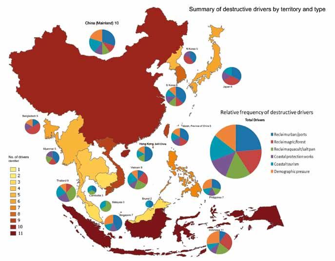
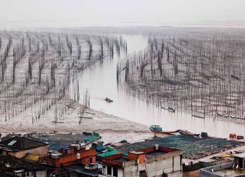
The designation of geographical entities in this book, and the presentation of the material, do not imply the
expression of any opinion whatsoever on the part of IUCN or the compilers concerning the legal status of
any country, territory, or area, or of its authorities, or concerning the delimitation of its frontiers or boundaries.
The views expressed in this publication do not necessarily reflect those of IUCN or other participating
organizations.

Published by: IUCN, Gland, Switzerland

Copyright: © 2012 International Union for Conservation of Nature and Natural Resources
Reproduction of this publication for educational or other non-commercial purposes is authorized without
prior written permission from the copyright holder provided the source is fully acknowledged. Reproduction
of this publication for resale or other commercial purposes is prohibited without prior written permission of
the copyright holder.

Citation: MacKinnon, J., Verkuil, Y.I. & Murray, N. 2012. IUCN situation analysis on East and Southeast Asian
intertidal habitats, with particular reference to the Yellow Sea (including the Bohai Sea). Occasional Paper of
the IUCN Species Survival Commission No. 47. IUCN, Gland, Switzerland and Cambridge, UK. ii + 70 pp.

ISBN: 978-2-8317-1255-0

Photo credits: Tony Mok (cover photo, Seaweed farming on the Xiapu mudflat, Fujian County, China), Jeong
Ahn (photo page 13), Jan van der Kam (photo in Fig. 3, page 7), Ju Yung Ki (photos Box 2, page 18), Nick
Murray (photos Fig. 10, Appendix 9)

Available from: IUCN (International Union for Conservation of Nature)
Publications Services
Rue Mauverney 28
1196 Gland
Switzerland
Tel +41 22 999 0000
Fax +41 22 999 0020
books@iucn.org
www.iucn.org/publications

Also available at www.iucn.org/asiancoastalwetlands

About IUCN
IUCN, International Union for Conservation of Nature, helps the world find pragmatic solutions to our most
pressing environment and development challenges. IUCN works on biodiversity, climate change, energy,
human livelihoods and greening the world economy by supporting scientific research, managing field
projects all over the world, and bringing governments, NGOs, the UN and companies together to develop
policy, laws and best practice. IUCN is the world’s oldest and largest global environmental organization,
with more than 1,200 government and NGO members and almost 11,000 volunteer experts in some 160
countries. IUCN’s work is supported by over 1,000 staff in 45 offices and hundreds of partners in public,
NGO and private sectors around the world. Web: www.iucn.org

IUCN Species Survival Commission
The Species Survival Commission (SSC) is the largest of IUCN’s six volunteer commissions with a global
membership of 8,000 experts. SSC, working with the Global Species Programme of IUCN, advises IUCN and
its members on the wide range of technical and scientific aspects of species conservation and is dedicated
to securing a future for biodiversity. SSC has significant input into the international agreements dealing with
biodiversity conservation. Web: http://www.iucn.org/about/work/programmes/species/about_ssc/index.cfm

IUCN Asia Regional Office
IUCN’s Asia programme is served by the IUCN Asia Secretariat, based out of the Asia Regional Office
(ARO) in Bangkok, Thailand, in close collaboration with IUCN Headquarters in Gland, Switzerland. The
IUCN Secretariat has some 300 staff in country and liaison offices in Bangladesh, Cambodia, China,
India, Lao PDR, Nepal, Pakistan, Sri Lanka, Thailand and Viet Nam. To address the challenges in
managing the large transboundary ecosystems of Asia and respond to the demands of the constituents,
the Asia Region has realigned to form three subregional groups: a Southeast Asia Group managed by a
Group Head (Cambodia, Indonesia, Lao PDR, Singapore, Thailand, Timor-Leste and Viet Nam); a South
Asia Subregional Group (covering all the South Asian countries) headed by one of the IUCN Country
Representatives in South Asia on a rotational basis; and a North and East Asia Subregional Group
managed directly by the Regional Director working closely with the Country Representative of China
(China, Mongolia, Japan, North Korea and South Korea).
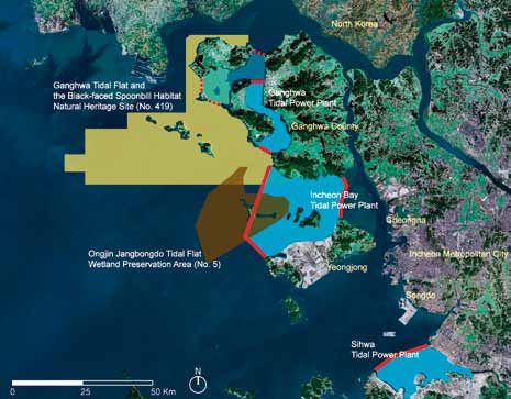
Table of Contents
Executive Summary................................................................................................................................. ii
1. Introduction....................................................................................................................................... 1
2. Methodology of study....................................................................................................................... 2
3. The intertidal zone of East and Southeast Asia................................................................................ 4
4. Why mud matters – the importance and values of intertidal habitats............................................. 4
5. Identification of critical sites and species........................................................................................ 5
6. Parallel declines in other taxa and services..................................................................................... 8
7. Threats to the intertidal zone.......................................................................................................... 11
8. Vanishing intertidal habitats............................................................................................................ 13
9. Direct links between species decline and habitat loss due to land reclamation........................... 16
10. Implications for fisheries................................................................................................................. 19
11. Threats to land and property.......................................................................................................... 20
12. Review of drivers of coastal zone reclamation............................................................................... 21
13. Review of protective measures and tools available....................................................................... 23
14. Conclusions ................................................................................................................................... 29
Acknowledgements............................................................................................................................... 30
List of abbreviations and acronyms...................................................................................................... 31
References............................................................................................................................................. 32
Appendix 1. List of globally threatened and Near Threatened waterbird species of intertidal
     habitats in East Asia........................................................................................................................ 38
Appendix 2. List of key areas for waterbirds, and particularly shorebirds, in the EAAF, with
     specific threats................................................................................................................................ 42
Appendix 3. Major problems, drivers and possible solutions to reduce loss of intertidal habitats
     and biota......................................................................................................................................... 48
Appendix 4. List of major international programmes with direct relevance to the EAAF..................... 51
Appendix 5. Matrix of issues affecting different countries/territories.................................................. 52
Appendix 6. Comparative review of protected area legislation and management............................... 53
Appendix 7. Comparative table of legislative procedures for EIA /SEA by country/territory............... 54
Appendix 8. Participation in Multilateral Environmental Agreements and associated actions............ 56
Appendix 9. A selection of case studies in key areas........................................................................... 57
Appendix 10. List of attendees of the 6th Meeting of Partners of the East Asian-Australasian
     Flyway Partnership (EAAFP MOP6), 19–22 March 2012, and the 9th Spoon-billed Sandpiper
     Task Force Meeting, 23–24 March 2012, Palembang, Indonesia................................................... 60
Appendix 11. The 388 sites considered in the IUCN situation analysis to identify key areas.............. 62

                                                                                                                                                             Intertidal Report • i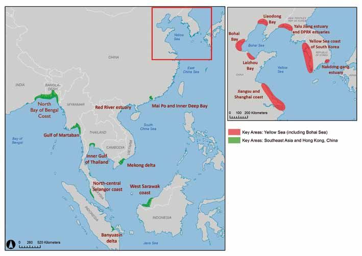
Executive Summary
                         The IUCN Species Survival Commission and IUCN Asia Regional Office commissioned this independent
                         report to assess the state and condition of intertidal habitats along the East Asian-Australasian Flyway
                         (EAAF), in response to growing concerns expressed by IUCN members over observed declines in
                         biodiversity, the loss of ecological services, and an increase in ecological disasters. This report is a
                         situation analysis, and it seeks to gather in one place the relevant data and analyses, and to present as
                         clear a picture of the status of the intertidal zone in the EAAF as the data allow. By intention, this report
                         makes no recommendations, but it should serve as a resource for those stakeholders empowered to
                         make or influence decisions and policies in the region.

                         This report makes use of the status and population trends of key species of waterbirds as indicators of
                         the environmental health of intertidal habitats (including beaches, marshes, mudflats, mangroves and
                         seagrass beds). It presents an analysis of ~390 coastal sites used by waterbirds along the EAAF and
                         identifies 16 key areas. The findings presented show that there is cause for significant concern over the
                         status of the intertidal zone along the EAAF. Fisheries and vital ecological services are collapsing and
                         ecological disasters increasing, with concomitant implications for human livelihoods. Observed rates
                         of declines of waterbird species of 5–9% per year (and up to 26% per year for Critically Endangered
                         Spoon-billed Sandpiper Eurynorhynchus pygmeus) are among the highest of any ecological system on
                         the planet. Breeding success among migrating species in their Arctic breeding grounds and survival on
                         most wintering grounds (for northern breeding species) at the southern end of their migrations appears
                         satisfactory, at least where hunting is sustainable. However, problems clearly are occurring along the EAAF
                         during migration. Unless major steps are taken to reverse current trends, the EAAF is likely to experience
                         extinctions and associated collapses of essential and valuable ecological services in the near future.

                         Although all sectors of the EAAF face a variety of threats, the Yellow Sea (including the Bohai Sea)
                         emerges as the focus of greatest concern, with six of 16 key areas identified in this report in the region.
                         Here, the fast pace of coastal land reclamation is the most pressing threat. Remote sensing and
                         geographical information system (GIS) analyses show mean losses of 35% of intertidal habitat area
                         across the six key areas of the Yellow Sea since the early 1980s. Losses of such magnitude are likely the
                         key drivers of declines in biodiversity and ecosystem services in the intertidal zone of the region.

                         This report reviews the drivers that are leading to such environmental degradation. We evaluated the
                         processes that should maintain or restore a balance between developmental needs and environmental
                         needs (including legal instruments, financing, habitat and species conservation, awareness and
                         knowledge), and found that these were usually weak, and were in some cases dysfunctional. Drivers are
                         reviewed at both the national and site-specific level. The report highlights the risks to biodiversity, to the
                         livelihoods of coastal communities, and to economic investments if the ‘business as usual’ scenario
                         continues. The stakes are very high including financial loss to the fisheries sector and the potential
                         financial damage and loss of coastal cities, towns and lands.

                         The countries along the EAAF have made commitments to global biodiversity targets under several key
                         multilateral environmental agreements, but it will not be possible for the countries to meet these
                         commitments without halting the declining trends in species populations and habitat availability and
                         quality identified in this report. Each country’s economic and environmental sustainability is being
                         damaged by the actions of its neighbours. Various existing regional seas initiatives are failing to address
                         these specific problems. The fast pace and nature of human developments affecting the EAAF
                         jeopardizes species that depend on this zone as well as the valuable ecological services that intertidal
                         zone ecosystems deliver to humans. Different species use different suites of sites during northbound
                         and southbound migrations. Therefore, protection of only the best sites will not provide an adequate site
                         network for all migratory species and broader protection of a comprehensive and complementary set of
                         sites is necessary.

                         Although this is a situation analysis and does not include recommendations, we allow ourselves this
                         comment. The birds and habitats of the EAAF are the shared natural heritage of 22 countries. Many of
                         the steps that need to be taken to secure this resource in the long term will require international
                         cooperation. Unless the fast economic development of this region can be balanced with adequate
                         environmental safeguards, impressive-looking economic gains could be short-lived and undermined by
                         the loss of valuable ecosystem services and a growing list of costly ecological disasters.

ii • Intertidal Report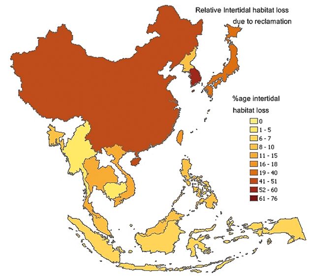
1. Introduction
Intertidal flats, the narrow band of habitat between the marine, freshwater and land environments,
are characterized by regular tidal inundation, low slopes and muddy deposits (Healy et al. 2002).
They provide ecosystem services such as food, shoreline stabilization, protection from storm events,
maintenance of biodiversity and are often at the centre of social activities (Millennium Ecosystem
Assessment 2005).

Globally, approximately 35% of mangroves were lost between 1980 and 2000 (Giri et al. 2011) and
some 30% of seagrasses have been lost in the last ~100 years (Waycott et al. 2009). For intertidal
flats, which are similarly heavily impacted by human influence, we have less certainty of their
present distribution, status and trends (Healy et al. 2002, Millennium Ecosystem Assessment 2005,
Keddy 2010). However, current estimates of the rate of intertidal habitat loss in Asia are equal to or
greater than recorded losses of mangroves (Giri et al. 2011), tropical forest (Achard et al. 2002) and
seagrasses (Waycott et al. 2009). For example, over the past 50 years, losses of up to 51% of coastal
wetlands (including marshes) have occurred in China (An et al. 2007b), 40% in Japan, 60% in the
Republic of Korea (ROK), and more than 70% in Singapore (Hilton & Manning 1995, Yee et al. 2010).

Birds serve as excellent indicators of environmental health and change. They occupy a wide range of
niches, use many types of food and physical resources, and are sensitive to environmental changes.
Just as nineteenth century miners looked to their caged canaries as an indication that it was safe to
continue breathing the mine air, we use data on fluctuating bird populations (Rogers et al. 2006c) to
alert us of modern environmental dangers. Birds are studied and monitored by considerable numbers
of ornithologists and researchers, yielding unparalleled data on population trends over time. Like
the canaries, the recent reports of major declines of waterbirds migrating through the East Asian-
Australasian Flyway (EAAF, Figure 1) are an indication of significant environmental changes that
require urgent investigation. A higher number and proportion of waterbirds are globally threatened in
the EAAF than in any of the other seven major flyways of the world (Kirby 2010; see Figure 2). Most
of these species are dependent on tidal flats, in particular 24 globally threatened or Near Threatened
species of shorebirds, waterfowl, spoonbills, cranes, seabirds and pelicans (IUCN 2011), plus a
further nine shorebird species currently under review which could be classified as threatened or Near
Threatened in the near future.

The loss of intertidal areas along migratory pathways, especially staging sites (where birds must
replenish their energy stores during migration for long, energetically expensive flights) can have
extreme consequences for shorebird populations (Myers et al. 1987, Goss-Custard et al. 1995, Baker
et al. 2004, Buehler & Piersma 2008, Warnock 2010, Rakhimberdiev et al. 2011). For the millions of
shorebirds that migrate through the East Asian-Australasian Flyway, the intertidal areas of Asia are a
crucial migratory bottleneck (Barter 2002, 2003, Bamford et al. 2008, Cao et al. 2009, Rogers et al.
2010, Yang et al. 2011a).

Apart from being vital habitat for the survival of millions of birds of more than a hundred species,
intertidal habitat is critical as nesting beaches for sea turtles, breeding areas for Asia’s seals,
spawning grounds for important economic fisheries, and homes of thousands of species of
invertebrates. Many species that rely on intertidal habitats in Asia are in trouble; for example, five
species of intertidal sea grasses are globally threatened (Short et al. 2011) and the eastern Taiwan
Strait population of the Indo-Pacific Humpback Dolphin Sousa chinensis is Critically Endangered
(Ross et al. 2010).

This situation analysis was initiated by the IUCN to synthesize available information on status, trends
and threats, identify areas most at risk of destruction and provide guidance to begin to conserve
these important ecosystems. To complete the synthesis, a review focusing on three key inputs
was undertaken: (i) an extensive review of published and unpublished literature; (ii) an analysis of
published and unpublished data from a range of sources; and (iii) expert input from regional and
local experts.

                                                                                                          Intertidal Report • 1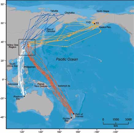
Figure 1. A) The eight broad flyways of waders / shorebirds. B) The East Asian-Australasian Flyway (EAAF). The arrows
     schematically show the many routes taken by migratory waterbirds travelling along this part of the globe (Boere & Stroud
     2006, Bamford et al. 2008). In reality the migration routes of one species can cover large parts of the flyway as individual birds
     consistently take different routes on northbound and southbound trips (Minton et al. 2011, Battley et al. 2012). The journeys
     toward the breeding grounds largely converge on the Yellow Sea (including the Bohai Sea), which serve as a major refuelling
     station between March and May each year.

     A)                                                                                           B)

          Pacific Americas
          Mississippi Americas
          Atlantic Americas
          East Atlantic
          Black Sea/Mediterranean
          West Asia/East Africa
          Central Asia
          East Asian - Australasian

                                      2. Methodology of study
                                      Overview
                                      This situation analysis is based on an extensive systematic literature review and supplemented with
                                      expert review and input from around the globe. A wide range of data on waterbirds and selected
                                      other taxa, habitat loss and threatening processes was compiled and analysed to identify which are
                                      the most important and vulnerable areas for biodiversity conservation. This analysis focuses on the
                                      drivers that are causing, or threaten to cause, the most severe losses of intertidal ecosystems and the
                                      services they provide, both in general across the entire EAAF and specifically in the most important
                                      sites. Information on past, current and future plans for land reclamation of intertidal habitats gives
                                      an indication of the sites most seriously at risk. Several case studies are presented, offering detailed
                                      information on the sites that are either most threatened or most important for waterbird migration.

                                      Data and Databases
                                      Expert elicitation
                                      A request to solicit facts, views and opinions was sent by the Director General of the IUCN to relevant
                                      government agencies of all of the governments and non-government organizations associated with
                                      the countries and territories covered in this study. The responses received were incorporated in the
                                      study, and are available on request from the authors. Further, the authors attended the 6th Meeting of
                                      Partners of the East Asian-Australasian Flyway Partnership, where extensive discussions were held
                                      with experts and government officials.

                                      Bird populations
                                      On the basis of data availability and sensitivity of species to environmental change, we selected the
                                      waterbirds (including shorebirds such as sandpipers, plovers, snipes and allies) confined to intertidal
                                      zones and the intertidal habitats (see list in Appendix 1) as the most appropriate indicators in our
                                      analysis. Indeed, waterbird species that inhabit intertidal areas give us a convenient and powerful
                                      indication of ecosystem well-being, given that they are at the top of the food chain (Mallory et al.
                                      2006) and we have good monitoring data for these species (e.g. Li et al. 2007, 2009b, Bamford
                                      et al. 2008). A database containing information on the abundance, distribution, conservation status
                                      and other pertinent details of 155 species of waterbirds that depend on East Asian intertidal and
                                      associated habitats was established. Of the 155 species, 24 are globally threatened (i.e., Critically

2 • Intertidal Report
Endangered, Endangered or Vulnerable on the IUCN Red List of Threatened Species;
www.iucnredlist.org) or Near Threatened (see Appendix 1); 711 are migratory shorebirds (including
gulls and terns) (see Section 5). In addition, we present trend data on selected shorebird populations
for the key areas identified in this analysis and the total EAAF (made possible through data provided
by the University of Queensland and the Australasian Wader Studies Group).

Important sites and key areas
By collating information on Important Bird Areas (BirdLife International 2001), EAAF Migratory
Waterbird partnership sites, Internationally Important Shorebird Sites (Bamford et al. 2008), and
coastal protected areas, 388 coastal sites were identified for inclusion in this study (Appendix 11).
From this group of sites, a subset of sites (Appendix 11; sites in bold) were determined to have high
numbers of globally threatened or Near Threatened waterbirds, high shorebird diversity or large
shorebird populations of at any time of year. Specifically, the subset included sites that had the
greatest values for these three factors:

1. The number of globally threatened and Near Threatened shorebird species and other tidal
   waterbirds;
2. Number of shorebird species present with >1% of the total EAAF population (using peak high
   counts, any time of year);
3. Total abundance of shorebirds.

To analyse the final subset of sites, we pooled them into key areas, based on their geographic
location. Sites that were situated closely along continuous stretches of intertidal habitats were
considered as one key area. A total of 16 key areas were identified (Section 5, Appendix 2). Using
information from the literature review, published and unpublished data sources, and from the expert
consultation process, an analysis of each key area was completed. For each key area we determined:

1. Protected area coverage (Appendix 2);
2. Where possible, the conservation status of each key area, both national and international, and
   inclusion or potential inclusion on the Ramsar list of internationally important wetlands (BirdLife
   International 2005) (Appendix 2);
3. The biodiversity features according to the factors mentioned above (Appendix 2);
4. The area of intertidal wetlands pre-2000 and current (post 2010). Where possible, published
   sources were used. For areas where no information was available, we used an unpublished remote
   sensing dataset of tidal flats of East Asia by Murray et al. (unpubl. data). Extent of tidal areas was
   calculated using satellite images of known tide height from the Landsat Archive. High-tide and low-
   tide images were differentiated to determine the area of tidal flat lost between the two time periods
   (Appendix 2);
5. The proportion of intertidal wetlands affected by land reclamation (Table 4 and Appendix 2);
6. Drivers and threats to these sites (Appendix 2).

The study also presents case studies of some of the most threatened and most important sites for
waterbirds (Appendix 9).

Policy analysis
Policy analysis involved identifying the major threats to coastal ecosystems and seeking the
underlying causes behind those threats. It included a review of the policy, legislation, Environmental
Impact Assessment (EIA) and Strategic Environmental Assessment (SEA) processes, Protected
Area (PA) coverage and management of each country against the background of the types of socio-
economic development in those countries. We employed simple scaled rating scores dependent on
expert opinion and review.

Public review
A one month period of public review was held, whereby officials of each country and other interested
parties were given opportunity to comment on the draft of the entire report. All comments received
were collated and considered for incorporation into the final report.

1 Not including Grey-headed Lapwing Vanellus cinereus, Australian Pratincole Stiltia isabella, Northern Lapwing
  Vanellus vanellus, and Long-billed Plover Charadrius placidus, which do not use tidal flats and/or are sedentary.

                                                                                                                      Intertidal Report • 3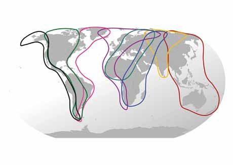
3. The intertidal zone of East and Southeast Asia
                                 The intertidal zone of East and Southeast Asia extends for 34,000 km from China and the Koreas,
                                 down along the coasts of Vietnam, Cambodia, Thailand, Peninsular Malaysia and north around the
                                 coast of Myanmar to Bangladesh. An even greater length, 128,000 km, of coastline surrounds the
                                 islands of Japan, island states of the Association of Southeast Asian Nations (ASEAN) – Philippines,
                                 Malaysia (East), Indonesia, Brunei, and Singapore – and East Timor.

                                 The coasts of Asia range from cold temperate to tropical and offer a range of habitats from mud to
                                 sand, marshes to mangroves. These habitats are biologically very productive, important for a wide
                                 range of biota, provide a range of very valuable ecosystem services and support the livelihoods of
                                 large human populations (see Section 4). Of particular value to wildlife are the tidal estuaries of some
                                 of Asia’s great rivers, including the Yellow, Yangtze, Red, Mekong, Irrawaddy, Salween and Ganges.
                                 These tidally influenced river mouths emerge as the most important habitat for globally threatened
                                 waterbirds (see Appendix 2).

                                          Asia’s eastern coastline serves as a migration flyway for the many species that nest in north-eastern
                                          Russia and Alaska, but spend the non-breeding season in Asia, or head south to Australasia. Many
                                                                               species migrate annually through this Flyway, from the high Arctic
                                                                               to Indonesia (e.g. Battley et al. 2005, Crossland et al. 2010, Iqbal et
     Figure 2. Total number and proportion of globally
                                                                               al. 2010) and as far west as Bangladesh and as far south as New
     threatened and Near Threatened waterbirds in
                                                                               Zealand (e.g. Melville & Battley 2006) and Australia (e.g. Barrett et
     the flyways of the world. Analysis and graphs
                                                                               al. 2003, Gosbell & Clemens 2006). At least 33 globally threatened
     reproduced from Kirby (2010).
                                                                               or Near Threatened waterbirds occur in the EAAF (of which 24
                  Proportion of globally threatened and Near Threatened
                                                                               are heavily dependent on the intertidal zone) with as many as nine
                                waterbird species by flyway                    additional shorebirds that may be listed as globally threatened
 Nspecies
        =   5/128     6/92      6/138   11/126   10/108   14/124 13/108 34/178 or Near Threatened soon (see Appendix 1). The EAAF is used
                                                                               by more waterbird species in total, and more globally threatened
        18
        16                                                                     or Near Threatened species, than any of the world’s other major
        14                                                                     migratory Flyways (Kirby 2010) (Figure 2).
     % species

                 12
                 10
                 8                                                      Although not specifically covered within the scope of this study,
                 6
                                                                        it should be noted that, in addition to the threats identified in the
                 4
                 2                                                      Asian sectors of the Flyway, there is an additional 5,000–6,000 km
                 0                                                      of important coastline in Russia that constitutes the northern end
                                                                        of the Flyway. For now, this sector is not extensively developed but
                                                                        Russia is developing fast especially the southern coast between
                                                                        Vladivostok and Sakhalin with oil gas and port development and
                                                                        adequate protected areas are not yet in place.

                                 4. Why mud matters – the importance and
                                 values of intertidal habitats
                                 The intertidal zone has long provided a wealth of services to humans. Earliest human remains are
                                 often found in association with mounds of sea-shells indicative of the importance of this zone as
                                 a harvesting area. The human menu was broadened to include the fish, birds and reptiles that
                                 also found their own foods along the shoreline. According to government figures, China alone had
                                 12.3 million people engaged in marine fishing in 2003 generating a catch valued at US$8 billion
                                 (Hanson & Martin 2006), with 70% of this figure realized in the coastal zone.

                                 Shorelines function as physical collecting zones of sand, mud, pebbles and fringe vegetation that
                                 help slow and break the action of waves. Gentle beaches tame ocean waves providing safe places for
                                 villages, harbours and towns and the protection of adjacent agricultural areas. The binding of sand,
                                 mud and other sediments helps keep seas clean and productive and removes many pollutants from
                                 the air and water. Increasingly, these habitats are being recognized for their ability to store carbon (blue
                                 carbon) (Decho 2000).

4 • Intertidal Report
Healthy strand vegetation, sea grass beds, algal beds and mangroves provide significant shelter in the
face of typhoons and storms and against the tsunamis that are frequent in a zone prone to devastating
earthquakes (Caldecott & Wickremasinghe 2005). Coastal damage seen after the great tsunami
in Aceh, Indonesia in 2004 revealed that sites protected by intact healthy coral, mangrove or other
coastal vegetation were dramatically less damaged than sites where these same habitats had been
destroyed (Chang et al. 2006, Forbes & Broadhead 2007).

Intertidal habitats are amongst the most productive ecosystems on earth. Intertidal habitats, including
tidal mudflats, tidal marshes and mangroves, provide safe spawning areas and nurseries for countless
species of fish and crustaceans on which coastal fisheries depend (Yusoff et al. 2006). They also
consolidate sediments into fertile new lands protecting offshore coral reefs from siltation and thereby
enhance the productivity of reefs and coastal waters. Clean, beautiful shorelines offer wonderful and
inspiring recreational opportunities, including for gastronomic tourism associated with seafood, and
important local economies can develop as a result (Table 1).

Costanza et al. (1997) valued the ecosystem services of the coastal zone, mostly from coastal
wetlands, globally at US$14.2 trillion per annum (or 43% of all global ecosystem services). More
precise economic assessments of the values of these services need to be undertaken regionally. One
preliminary study by the Korean Ocean Research and Development Institute (KORDI 2006) came up
with the following estimates: annual value of a hectare of the ROK’s intertidal habitats (US$32,660),
which includes marine products (US$9,993), ecosystem preservation (US$8,548), habitat (US$7,533),
water purification (US$3,702), recreation (US$1,443), and disaster prevention (US$1,442). Ecosystem
service values for 170 km2 of intertidal flats planned for reclamation in Xinghua Bay, Fujian, China,
were estimated at US$0.65 billion/annum or US$38,235/ha/annum with an estimated loss of value
of US$8,250/ha/annum if the land were reclaimed for agriculture or ponds (Yu et al. 2008). Given
that there are more than 1 million ha of intertidal habitats in the Yellow Sea (including the Bohai Sea),
these estimates point towards service values exceeding at least US$30 billion per annum. An et al.
(2007b) estimate that the historical loss of 51% of China’s coastal wetlands (not all intertidal) resulted
in an annual loss of US$46 billion. The loss of ecosystem services caused by sea enclosures and land
reclamation in China has been estimated at US$27.76 billion/annum (CCICED 2010b).

Bennett & Reynolds (1993) point out that mangroves not only deliver a huge boon of services, but that
they also provide livelihood to large numbers of people. When intertidal habitat is converted there are
high financial gains, through mariculture, infrastructure and related jobs, however other social and
financial values are often not appreciated until they are lost (Wang et al. 2010b).

5. Identification of critical sites and species
Bird declines
The coastal intertidal zone is narrow. The total area involved is very small, fragile and is rapidly
vanishing. Indeed, several countries have already lost between 40% and 55% of all intertidal habitat
(Davidson 2011). The region of greatest habitat loss is the Yellow Sea (including the Bohai Sea) region
(for details see Section 8), which is a critical convergence for many migration routes (Barter 2002,
Heo 2000, Yi 2003, 2004).

Many birds that use intertidal habitats are migrants and travel annually along the EAAF. They connect
continents and countries and are, therefore, excellent environmental indicators at both global and
local scales (Battley et al. 2008). Of the 155 species of waterbirds that depend on East Asian intertidal
and associated habitats, at least 50 species of migratory shorebirds and 21 migratory gulls and
terns in the EAAF are strongly dependent on intertidal habitats (Table 2). Fifteen globally threatened
or Near Threatened migratory intertidal species, including the Endangered Spotted Greenshank
Tringa guttifer and the Critically Endangered Spoon-billed Sandpiper Eurynorhynchus pygmeus and
Chinese Crested Tern Sterna bernsteini (Chan et al. 2010a), have more than 95% of their entire global
population in the EAAF; at least one species entirely confined to the EAAF and currently listed as
Least Concern, Grey-tailed Tattler Heteroscelus brevipes, is likely to be listed as threatened in the
near future (Appendix I). A further six migratory shorebird species, currently listed as Least Concern,
also have more than 95% of their entire global population in the EAAF (Sharp-tailed Sandpiper

                                                                                                             Intertidal Report • 5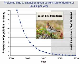
Table 1. Summary of the main ecosystem services provided by mudflats and mangroves of the intertidal zone in East and Southeast Asia (following
   typology of Ranganathan et al. 2008).

    Services/benefits provided           Notes                                                                     Vulnerability                            References
    Provisioning Services
    Sustainable fisheries                About 30 million fishermen in the entire study area depend on nets        Reclamation, overharvesting, alien       Rönnbäck 1999,
                                         and fish traps in the tidal zone for their livelihood. A huge volume of   species and pollution all threaten       TEEB 2010
                                         shellfish and sea cucumbers is also harvested. The intertidal zone        fisheries which are now in serious
                                         is also an important nursery area for many economically important         decline
                                         deep-water species
    Biochemical                          Extraction of medicines and other materials from biota (fish,             Loss of biota and habitats               Constanza et al.
                                         molluscs, corals, jellyfish)                                                                                       1997
    Genetic materials                    For example, spread of genes for resistance to plant pathogens or         Loss of biota and habitats               Wilson et al.
                                         hybridization with ornamental species                                                                              2005
    Harvest of non-timber forestry       Honey, resins, tannins, edible nuts, seaweeds, shells                     Loss of mangroves and beach forest       TEEB 2010
    products
    Silviculture/aquaculture             Intertidal zone used for rearing commercial species of plants and         Productivity threatened by pollution     Bennett &
                                         animals (crustaceans, fish, pearls, mangroves, algae)                     and loss of habitat. Over development    Reynolds 1993,
                                                                                                                   of aquaculture can lead to spread of     Wilson et al.
                                                                                                                   diseases, pollution and invasive alien   2005
                                                                                                                   species
    Regulating Services
    Detoxification and purification of   Mud, gravel and their fauna of worms, molluscs and crustaceans            Loss of purification role leads to       Wilson et al.
    water resources                      remove pollutants from water                                              dangerous outbreaks of red and green     2005
                                                                                                                   algal blooms and dangerous toxins in
                                                                                                                   seafood
    Climate regulation and carbon        Mudflats are important carbon sinks that help to regulate climate         Reclamation converts important           Decho 2000
    sequestration and fixation           change through the process referred to as ‘blue carbon’                   carbon sinks into carbon sources
    Coastal protection/natural           Mudflats and beaches disperse and break tidal action and safeguard        Reclamation focuses and increases        Caldecott &
    hazard protection                    shorelines from cyclones, tsunamis, erosion and salination.               wave action and accelerates scouring     Wickremasinghe
                                         Mangoves protect coastal villages                                         at other parts of coastline increasing   2005, Chang et
                                                                                                                   risk of storm damage and floods. Loss    al. 2006, Forbes
                                                                                                                   of coastal vegetation leaves coastline   & Broadhead
                                                                                                                   vulnerable to storms and sand storms     2007
    Water regulation (hydrological       Groundwater recharge/discharge                                                                                     Wilson et al.
    flows)                                                                                                                                                  2005
    Cultural Services
    Educational                          Opportunities for formal and informal education and training                                                       Wilson et al.
                                                                                                                                                            2005
    Coastal tourism, landscape           Beauty and inspiration by the big swirling flocks of shorebirds           Conversion, reclamation and              Wilson et al.
    diversity and scenic values          and the science behind seasonal long-distance migration of birds          development along the shoreline          2005, Woodley
    including watching migrating         and mammals adds to property values and supports large tourism            compromise aesthetic values. The         2009
    birds, marine mammals etc.           industry that caters for more than 100 million tourists per year          amazing athletic physiology of birds
    Eating fresh seafood, boating,                                                                                 covering 8,000 km or more in single
    surfing                                                                                                        flights, not sleeping or drinking for
                                                                                                                   over a week
    Supporting Services
    Habitat for birds and other          Many charismatic, rare and important species depend on this               Reclamation, cutting of mangroves,       Bennett &
    wildlife                             zone. They are easily viewed on open flats and beaches adding to          introduction of alien plants and         Reynolds
                                         recreational and conservation values (see Cultural Services above)        pollution all destroy wildlife habitat   1993, BirdLife
                                                                                                                                                            International
                                                                                                                                                            2005
    Nutrient recycling                   Storage, recycling, processing, and acquisition of nutrients              Changes to seawater chemistry result     Bennett &
                                                                                                                   in loss of many important species        Reynolds 1993,
                                                                                                                   and negative changes in benthic          Constanza et al.
                                                                                                                   communities. Shortage of oxygen          1997
                                                                                                                   destroys many economic species
    Nutrient export                      Outwelling of organic nutrients and detritus increases productivity of    Loss of biological productivity of       Wolanski 2007
                                         local fisheries and nourishes plankton communities                        intertidal zone due to pollution or
                                                                                                                   habitat loss
    Soil formation                       Sediment retention and accumulation of organic matter                     Lost through coastal erosion             Wilson et al.
                                                                                                                                                            2005

6 • Intertidal Report
Calidris acuminata, Red-necked Stint C. ruficollis, Long-toed Stint C. subminuta, Pacific Golden
Plover Pluvialis fulva, Oriental Pratincole Glareola maldivarum and Swinhoe’s Snipe Gallinago megala).
There are indications of serious declines in some bird populations along the EAAF. Of all monitored
populations of Arctic breeding shorebirds in north-eastern Russia, 89% now show declines (E.
Syroechkovskiy, pers. comm.). Monitoring on beaches of Australia reveals declines in the numbers
of EAAF migrant shorebirds wintering there (Gosbell & Clemens 2006, Wilson et al. 2011, Szabo et
al. 2012). Analysis of monitoring data of Japanese shorebirds between 1975 and 2008 evidenced
declines in most species, especially those that stop at the Yellow Sea (including the Bohai Sea)
(Amano et al. 2010). The fastest declining migratory shorebirds in the EAAF are the long-distance,
Arctic-breeding migrants, such as the Spoon-billed Sandpiper (Amano et al. 2010, Zöckler et al.
2010b) (Figure 3) and the Red Knot Calidris canutus (Wilson et al. 2011, Garnett et al. 2011) (Figure 4).
At the current rate of decline (26% per annum), Spoon-billed Sandpipers could be extinct within the
decade despite ongoing conservation action (Pain et al. 2011) (Figure 3). Similarly, with the current
rates of decline, for every 100 Red Knots migrating along the EAAF in 1992, only seven will be left in
2020 (Figure 4).
Identification of key areas
While migrating through the EAAF, shorebirds use areas with intertidal habitat. Throughout the EAAF
around 390 internationally important sites for shorebirds have been identified (Appendix 11), here
clustered into 16 key areas (Appendix 2). Six of these 16 key areas for shorebird biodiversity are in
the Yellow Sea (including the Bohai Sea) (Figure 5). It was only in the 1990s that the ornithological
importance of the Yellow Sea (including the Bohai Sea) became clear. It is possible that other key
areas remain to be discovered in less accessible parts of the EAAF, such as the west coast of DPRK.
Outside the Yellow Sea (including the Bohai Sea), ten areas in South and Southeast Asia with high
intertidal biodiversity were identified. Some of the areas in the south are mainly non-breeding sites
and are critical to the survival of particular species, such as the Spoon-billed Sandpiper (spending
the non-breeding season largely on Sonadia Island in Bangladesh and in the Gulf of Martaban in
Myanmar) and the Spotted Greenshank (dependent largely on the Malay Peninsula).
The six key shorebird areas in the Yellow Sea (including the Bohai Sea) support an overwhelming
majority of shorebirds migrating through the EAAF. At least 36 shorebird species (Barter 2006)
occur in internationally important numbers at 66 distinct shorebird sites (excluding the unknown
sites in DPRK). As many as 22 shorebird species strongly depend on the Yellow Sea (including the
Bohai Sea): 50–100% of the individuals use the Yellow Sea and Bohai Sea during northbound or
Figure 3. Population decline in Spoon-billed Sandpiper Figure 4. Population decline of Great Knots Calidris
Eurynorhynchus pygmeus showing measured current rate tenuirostris and of the EAAF populations of Red Knot
of decline and the projected trajectory to extinction if no Calidris canutus and Bar-tailed Godwit Limosa lapponica
additional conservation measures are taken(after Zöckler (for flyway routes see Figure 6). Shown are the measured
et al. 2010b; but see Pain et al. 2011). current rates of decline and the projected trajectories if
no further conservation measures are taken (after Amano
et al. 2010 and Wilson et al. 2011).
Intertidal Report • 7Table 2. Overview of the conservation status of waterbirds in general, and shorebirds (sandpipers, plovers, snipes and allies) in particular, in Asia and in
the East-Asian Australasian Flyway.
Status of waterbirds in Asia and the EAAF, from a global perspective Number of species References
All waterbird species in Asia and the EAAF
Total Asian waterbird species 349 Li et al. 2006
Total waterbird species dependent on intertidal flats in the EAAF 155 Li et al. 2009b
Globally threatened or Near Threatened waterbird species in the EAAF 24 Appendix 1
Shorebird, gulls and tern species in the EAAF
Total migratory shorebird species (sandpipers, plovers, snipes and allies) in the EAAF 54* Bamford et al. 2008
Total migratory gull and tern species depending on intertidal flats in the EAAF 21 Li et al. 2009b
Globally threatened or Near Threatened shorebird, gull and tern species in the EAAF 14 Appendix 1
Candidate EAAF shorebird species to be uplisted on IUCN Red List 9 Appendix 1
International comparison
Globally threatened and Near Threatened intertidal species in the EAAF 33 of 155 (21%) Appendix 1**
Globally threatened and Near Threatened waterbird species in Americas 18 of 202 (9%) Kirby et al. 2008
Globally threatened and Near Threatened waterbird species in Europe, C Asia, Africa & Middle East 26 of 162 (16%) Kirby et al. 2008
Globally threatened and Near Threatened waterbird species in Asia 46 of 201 (23%) Kirby et al. 2008
* Note that number includes Grey-headed Lapwing, Australian Pratincole, Northern Lapwing, and Long-billed Plover, which do not use tidal flats and/or are
sedentary.
** Includes species currently listed as LC, eligible for uplisting to Near Threatened or Vulnerable.
southbound migrations (Barter 2002, Battley et al. 2012) (e.g. Figure 6). In eight species, as much
as 70% of the population relies on the Yellow Sea (including the Bohai Sea) as a “fuel” stop (Barter
2002). All these species are declining: three species are Near Threatened (Great Knot Calidiris
tenuirostris, Far Eastern Curlew Numenius madagascariensis and Eurasian Curlew Numenius
arquata), two are globally declining (Bar-tailed Godwit Limosa lapponica) and Grey Plover Pluvialis
squatarola), and three are regionally declining (Dunlin Calidris alpina, Kentish Plover Charadrius
alexandrinus and Whimbrel Numenius phaeopus) (Amano et al. 2010, Battley et al. 2012).
6. Parallel declines in other taxa and services
Other taxa are undergoing declines parallel with birds (Table 3), further indicating the deteriorating
productivity and health of the intertidal zone. Cascading declines are being recorded throughout the
food web (WWF et al. 2006). In all areas of East and Southeast Asia, important stocks of economically
important fish, crustaceans, shellfish and cephalopods are collapsing, causing livelihood losses for
several million artisanal fishermen. In some countries, hunting for birds is increasing in response
to collapse of fish stocks. Sea mammals and turtles are also undergoing rapid declines, and many
are now threatened with extinction. The frequency of toxic algal blooms has increased dramatically;
temperature, acidity and water levels have risen (Nicholls & Cazenave 2010); the frequency of
catastrophic storms have increased (see Figure 8, Section 7), and the damage to coastlines from
cyclones and tsunamis is becoming more serious, especially where the natural coastline has been
destroyed (Caldecott & Wickremasinghe 2005).
8 • Intertidal ReportFigure 5. The 16 key areas for intertidal waterbird biodiversity in the East Asian-Australasian Flyway. See Appendix 2 for
detailed information on internationally important shorebird sites covered by the key areas and data on biodiversity values and
threats.
Key intertidal areas as identified by biodiversity of
waterbirds depending on tidal flats. Birds, top trophic
predators, were used as a convenient indicator of tidal
flat biodiversity given the relative availability of data on
bird numbers.
To select key areas the ornithological importance of ~390
sites with significant tidal flats for all coastal East and
Southeast Asian countries was assessed using three
parameters:
a) globally threatened and Near Threatened wader
species and other waterbirds using tidal flats at the site;
b) overall wader abundance;
c) wader populations of international importance (1% of
their biogeographical population).
Figure 6. The migrations of many
waterbirds converge in the Yellow Sea
(including Bohai Sea) region. Tracks in
figure are the routes of satellite-tagged
Bar-tailed Godwits Limosa lapponica on
northward migration. White/blue tracks
represent the menzbieri population (white:
north-west Australia to the Yellow Sea
region; blue: Yellow and Bohai Sea to the
breeding grounds in Siberia); red/gold
tracks represent the baueri population
(red: New Zealand to the Yellow and
Bohai Sea; gold: Yellow Sea region to
Alaska). Small circles along track lines
represent positions calculated from Argos
data. YKD: Yukon-Kuskokwim Delta,
KS: Kuskokwim Shoals. Taken from Battley
et al. (2012).
Intertidal Report • 9Table 3. Some documented examples of parallel biodiversity declines in other taxa and increasing catastrophes.
Change observed Comment Cause References
The output of prawns in the Bohai Sea This is an important economic catch. 20% Excessive fishing, over-exploitation, Qiao 2001
fell from more than 40,000 tonnes in of all China’s protein is marine-based. disease and pollution have severely
the 1970s to just 1,000 tonnes in 2004. Fish farming production now exceeds wild damaged this fishery resource. Legacy
A 1998 survey indicated that the total catch, but may not be sustainable and is of habitat damage caused by historical
biomass of fisheries was reduced by 89% dependent on catch of threatened supply trawling.
compared with 1992. of wild larvae.
147,000 km² of Chinese seas classified This constitutes maximum 3.7% of China’s Pollution from land-based and marine SOA 2009, CCICED
as in serious eutrophic situation in 2009. total marine area. sources, especially agricultural chemical 2010b, Cao & Wong
Liaodong Bay, Bohai Bay, Laizhou bay, run off. 2007
Yangtze Estuary, Hangzhou Bay and
Zhujiang Estuary are the worst affected.
Shellfish population on the east coast of 154 species in 1960s reduced to 33 in Sustained land reclamation and urban Liu & Sun 2008
Jiaozhou Bay, Shandong, China, is at the 1980s and only 17 in 1980s with only encroachment.
brink of extinction. one of the original 14 dominant species
remaining.
Sea horses and other fish are undergoing Fish species are taken as foods, as fish Loss of key nursery areas plus TEEB 2010
dramatic declines throughout the tropical meal to use in aquaculture, for ornamental overharvesting, use of destructive trawls,
region. fish trade and as traditional medicines. fine nets, traps, explosives and poisons.
Serious declines in all marine mammals of Spotted Seal Phoca largha breeding sites Pollution leads to reproductive failure, loss Smith & Yan 2008, Ross
Yellow Sea. on winter ice flows of Bohai Sea and of fish prey to starvation, habitat loss on et al. 2010
summer resting places on islands of Yellow summer beaches and accidental death in
Sea are all threatened. fishing nets.
Serious loss of coastal vegetation Many commercially important plants Habitat loss due to reclamation, fishponds, Zhang et al. 2005
throughout the region including major loss are declining – reed harvest, medicinal salt-pans combined with invasion by alien
of mangroves (China has lost 73% since species, fodder species, plants used by species such as Spartina cord grass.
1950s). fisheries and ecological and physical
fixation of coastal sediments.
Important beds of seaweeds and sea Many edible species of algae being lost; Pollution, changes in nitrogen levels and WWF et al. 2006, Short
grasses seriously damaged and declining sea grasses important for wildlife (five salinity caused by damming estuaries et al. 2011
throughout the region. species in the EAAF globally threatened);
single celled algae important for fishery
food chains, shorebirds and carbon
fixation.
Dramatic increase in jellyfish blooms in the Injury to humans, loss of tourism revenues, Overfishing of jellyfish larval predators, Xian et al. 2005,
Yellow Sea (including the Bohai Sea). indirect reduction of fisheries. litter provides habitat for jellyfish and Kawahara et al. 2006,
jellyfish prey on fish larvae. Titelman & Hansson
2006, Dong et al. 2010
Regional populations of Green Turtle Previously distributed widely throughout Caught in fishnets, nest disturbance, Song et al. 2002,
Chelonia mydas, have declined the waters of China and commonly found ingestion of litter, loss of coastal habitat Wallace et al. 2011
dramatically in recent years. Presently only on nesting beaches in South China. The and impact of severe pollution.
seven natural beaches in South China are only remaining mainland nesting beach is
utilized by nesting Green Turtles. located in the Gangkou Sea Turtle National
Nature Reserve (114o2’E, 22o3’N) in
Guangdong.
Biotic community structure changed from In an effort to restore the large loss of Biomass loss was caused by construction Zhen et al. 2006.
crustacean to molluscs dominated in biomass, 15 tons of benthic organisms of deep water channel in Yangtze River
Yangtze Estuary. were returned between 2002 and 2004, Estuary.
but the resultant community changed and
is less valuable.
Probability of lethally low oxygen levels This serious lack of oxygen leads to Pollution and loss of tidal cleansing Wei et al. 2007
(hypoxia) increased by 90% since 1990 collapse of marine ecosystems and functions increased by reclamations.
around Yangtze Estuary. fisheries resulting in dead zones.
Overall changes in biotic composition in Less big carnivorous fish, more small low Overfishing, pollution, habitat loss and Kim et al. 2007, UNDP/
Bohai and Yellow Sea. economic value fish, more jellyfish, less reduced river discharge (results in lowering GEF 2009, Yang et al.
diatoms and more flagellates. of Si/N ratio). 2011b
Frequency of harmful algal blooms (HAB) Causes direct economic losses estimated Pollution and loss of tidal cleansing Zhou et al. 2001, Song
increased 3.4 times since 1990s, now at $285 million annually in China alone functions increased by reclamations. 2007
affecting 16,300 km2 in Yellow Sea. plus associated health risks.
10 • Intertidal ReportChange observed Comment Cause References
Small Yellow Croaker Larimichthys This was formerly one of the most Overfishing combined with changing Zhou 2004, Tang 2006,
polyactis has declined 80% since the abundant economic species of the Yellow nature of the Yellow Sea. High trophic Li et al. 2011
1960s in China and ROK. Sea accounting for 37% of total catch. species replaced by low trophic anchovy
and sandlance.
ROK has seen sharp declines in mollusc 50,000–90,000 tons of hard clams Saemangeum supply almost dried up since WWF et al. 2006
harvest. and 1000 tons of mud octopus were closing of the seawall gates in 2006.
collected annually in the ROK, mostly in
Saemangeum Estuary.
7. Threats to the intertidal zone
A multitude of destructive processes and issues are negatively affecting shorelines and the intertidal
zones of East and Southeast asia (Cheung et al. 2002). Questionnaires sent to managers of a number
of sites of the Flyway Partners revealed a variety of perceived concerns in listing threats faced
at individual sites (D. Watkins, pers. comm.; Figure 7). However, these sites are mostly protected
areas with some security from other land claims. On the basis of the scale, timing of declines,
irreversible nature of the threat, direct links to specific reclamations and measured bird losses, and
the combination of direct and indirect impacts, this report suggests that by far the most serious and
irreversible threat is the loss of habitat caused by reclamation of intertidal habitats for other uses such
as agriculture, fish ponds, salt-pans and increasingly ports, industrial sites, tourism and new urban
development. The following list, based on literature review and expert input lists the main threats to
intertidal habitats and biota in approximate order of severity.
· Loss and fragmentation of habitat. According to the China National Wetland Conservation
Action Plan (2000) some 1.19 million ha of coastal tidal flats have been lost and 1 million ha of
coastal wetlands have been urbanized or used for mining. This constitutes a loss of 51% of all
China’s coastal wetlands (Chen et al. 2005, CCICED 2010b, Bi et al. 2011). Mangroves decreased
from ~50,000 ha in 1950 to 22,700 ha in 2001 – a 44% loss (Chen et al. 2009). Loss of coastal
Figure 7. Proportional
responses received from
site managers of East
Asian-Australasian Flyway
sites to a questionnaire
about perceived threats
to each site. Courtesy
D. Watkins, Wetlands
International Oceania, 6th
Meeting of Partners of the
East Asian-Australasian
Flyway Partnership,
Palembang, March 2012.
Intertidal Report • 11wetlands continued and accelerated during the following decade. Much of the intertidal zone,
especially in the Bohai Sea, is now occupied by aquaculture cage and salt farms. Incredibly,
Asia accounts for 90% of the global aquaculture production with more than two-thirds occurring
in China (Naylor et al. 2000). Intertidal habitat loss is a threat in all countries of the study (see
Figure 9) (Bird Conservation Society of Thailand 2004, Trainor et al. 2008, Ardli & Wolff 2009,
Choi et al. 2010, Toril et al. 2010, Murray et al. 2011, Wen 2012). Countries not yet facing much
damage to habitat such as Myanmar (Naing 2007) are set to open up new developments, including
reclamation for deep sea ports which could be very damaging unless the preliminary planning and
zoning is sound. DPRK has also not yet reclaimed much of its coastline, but completed the 8,800-
ha Taegyedo Tideland Reclamation project in 2010 and has plans for more reclamations (KCNA
2010).
· Damming of many major rivers in the region has led to changes in silt discharge, seasonality
and quality of freshwater discharge (Chen et al. 2005, Syvitski et al. 2009, Wang et al. 2010a,
Yang et al. 2011b). Silt load of the Haihe River which flows into the Bohai Sea has reduced from
an average of 0.75 kg/m3 to 0.1 kg/m3 as a result of damming and upstream water extraction
(CCICED 2010b). Reduced discharge along the entire east coast of China has reversed the
shoreline accretion process resulting in a now receding shoreline (almost 5 m per year along
Hebei coast) which will impact recent coastal reclamations (CCICED 2010b) and reduce biological
productivity (Ning et al. 2010).
· Overuse of fertilizers, pesticides and herbicides in agriculture results in agricultural runoff to
the ocean, leading to excessive nitrogen loads and growing threats from harmful algal blooms in
many coastal areas (Tang et al. 2006). Blooms in 2008 and 2009 caused direct economic losses
of nearly US$300 million (CCICED 2010b). Antibiotics are also released from aquaculture, with
unknown consequences on coastal ecosystems (Wang et al. 2008, Gräslund & Bengtsson 2001).
· Pollution due to industrial emissions, wastewater and sewage discharges both directly and
indirectly (Li & Daler 2004) into the coastal zone (Sowana et al. 2011). Common pollutants include
phosphate, hydrocarbons, pesticides (Hu et al. 2009), inorganic nitrogen, heavy metals and
organic matter.
· Oil spills are an increasingly dangerous problem and are presently occurring with high frequency.
The South China Sea to Yellow Sea passage is the busiest shipping lane in the world. Accidental
leaks occur and oil rigs are becoming more common in the Bohai Sea and South China Sea. Major
oil spills and blow outs have already impacted many coastal habitats in the ROK and the Bohai Sea
of China, and there are hundreds of small leaks that are barely reported (CCICED 2010b).
· Plastic litter, on beaches and in the sea, is mildly toxic and occurs in ever greater volumes in all
coastal areas of the globe. Being non-biodegradable, plastics are a serious threat to all marine
wildlife. In the intertidal zone, plastics may be ingested by wildlife, contaminate feeding sites,
ensnare animals, reduce access to feeding and roosting sites, and directly impact individual
animals through entanglement. Seven shorebirds and a Chinese Egret Egretta eulophotes were
found caught in a single net on a single day in Gomso Bay (South Korea) (D. Rogers, pers. comm.).
· Tidal energy developments, which involve the construction of sea walls and tidal barrages, lead
to direct loss of tidal flats. These developments also change near-shore tidal flows, which leads to
increased impacts to siltation dynamics and damage to near-shore areas (Gill 2005). A large tidal
energy project is being developed at Incheon, ROK (see case study in Appendix 9).
· Overharvesting and overuse of intertidal resources, including fish, molluscs, sea-cucumber,
sea-urchins and seaweeds. The recent industrialization of harvesting methods has resulted in even
greater harvests of intertidal flora and fauna with less manual labour required, which is impacting
ecosystem processes throughout the intertidal zone. In most areas, the intertidal zone is a maze
of fishing platforms traps and nets that not only add to overfishing, but prevents adult fish from
reaching spawning nurseries (CCICED 2010b).
· Aquaculture/mariculture has developed so fast in some areas that it brings stress to coastal
and intertidal ecosystems, causing great changes to beaches, wetlands, seaweed beds and
coral reef ecosystems. Mariculture directly destroys the spawning grounds and habitat of fishery
resources, and further influences the regenerative capacity of fishery resources (CCICED 2010b).
The potential for a disastrous collapse in mariculture production and wild fisheries becomes
increasingly likely (see Section 10).
· Hunting using mist nets, fine fish nets, snares, egg collection, poison and guns is occurring on
or adjacent to beaches throughout the EAAF. For instance, while there are only a few hundred
Spoon-billed Sandpipers left globally, hunting of these birds continues at their major remaining
non-breeding area in Myanmar (Zöckler et al. 2010a). Additionally, fishing nets accidentally kill
significant shorebirds if left on flats at low tide.
12 • Intertidal ReportYou can also read