Joint ISO/TC211 and OGC Revision of the LADM: Valuation Information, Spatial Planning Information, SDG Land Indicators, Refined Survey Model ...
←
→
Page content transcription
If your browser does not render page correctly, please read the page content below
Joint ISO/TC211 and OGC Revision of the LADM: Valuation Information,
       Spatial Planning Information, SDG Land Indicators, Refined Survey
     Model, Links to BIM, Support of LA Processes, Technical Encodings, and
                            Much More on Their Way!

              Peter VAN OOSTEROM, The Netherlands, Abdullah KARA, Turkey,
            Eftychia KALOGIANNI, Greece, Anna SHNAIDMAN, Agung INDRAJIT,
                Abdullah ALATTAS and Christiaan LEMMEN, The Netherlands

   Key words: Standardization, Cadastre; Digital Cadastre; Land Management; Marine Cadastre;
   ISO; OGC; 3D; Valuation; Spatial Planning

   SUMMARY

   ISO standards, which are actually being applied, are subject to periodic revision, typically in a
   6 to 10-year cycle. A UN-GGIM Meeting of the Expert Group on Land Administration and
   Management was held on 14-15 March 2017, in Delft and the main conclusion was that the
   revision of LADM was indeed needed in order to provide better tools to improve tenure
   security and better land and property rights for all. It was also noted that land administration is
   a rather complex domain, and thus the revision will involve many stakeholders, namely: ISO,
   FIG, OGC, UN-Habitat, UN-GGIM, World bank, GLTN (Global Land Tool Network), IHO,
   RICS, etc..

   Further goals of the revision include: providing reliable Land Administration Indicators for the
   Sustainable Development Goals (SDG), developing standard(s) supporting a Fit-for-Purpose
   approach, paying attention to implementations and tools (not just conceptual model), and
   inclusion of valuation information (which might help to define/support the Fit-for-Purpose
   approach). In order to prepare the LADM revision, two workshops were organized: 16-17
   March 2017 (Delft) and 11-13 April 2018 (Zagreb), with experts involved in the development
   of the initial version of LADM and representatives of all the mentioned stakeholders. For the
   purpose of the revision, it is important to analyze and compare currently operational and
   proposed country profiles and their implementations of the first version of LADM, ISO
   19152:2012.

   This paper gives an overview of the status of developments and the related proposals.

Joint ISO/TC211 and OGC Revision of the LADM: Valuation Information, Spatial Planning Information, SDG Land
Indicators, Refined Survey Model, Links to BIM, Support of LA Processes, Technical Encodings, and Much More on
Their Way! (10079)
Peter van Oosterom, Abdullah Kara, Eftychia Kalogianni, Anna Shnaidman, Agung Indrajit and Abdullah Alattas
(Netherlands)
FIG Working Week 2019
Geospatial information for a smarter life and environmental resilience
Hanoi, Vietnam, April 22–26, 2019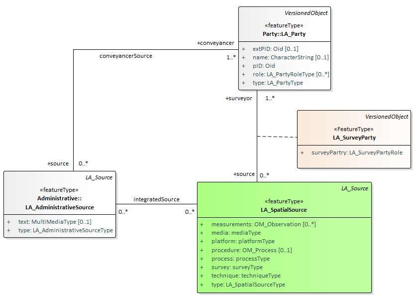
Joint ISO/TC211 and OGC Revision of the LADM: Valuation Information,
       Spatial Planning Information, SDG Land Indicators, Refined Survey
     Model, Links to BIM, Support of LA Processes, Technical Encodings, and
                            Much More on Their Way!

              Peter VAN OOSTEROM, The Netherlands, Abdullah KARA, Turkey,
            Eftychia KALOGIANNI, Greece, Anna SHNAIDMAN, Agung INDRAJIT,
                Abdullah ALATTAS and Christiaan LEMMEN, The Netherlands

        1. INTRODUCTION

   The development of the Land Administration Domain Model (LADM) was an initiative of the
   International Federation of Surveyors (FIG), see (Lemmen, 2012). In the beginning of 2008,
   after six years of preparations, FIG submitted a proposal to develop an International Standard
   for the Land Administration (LA) domain, to the ISO/TC 211 committee on Geographic
   Information of the International Organization for Standardization. The proposal received a
   positive vote and a project team started to work on the development of the standard.

   Within TC 211, many issues and comments have been discussed during several meetings, held
   with a project team composed of 21 delegates from 17 countries. After positive results of the
   voting on the so-called New Working Item Proposal (NWIP) in May 2008 and on the
   Committee Draft (CD) in October 2009, the Draft International Standard (DIS) received a
   affirmative vote in June 2011; the stage of International Standard in a first Edition was achieved
   in December 2012 (ISO, 2012). Each step of development process within ISO, includes reviews
   from the involved countries.

   The LADM is a knowledge domain specific standard capturing the semantics of the Land
   Administration domain. It provides a shared ontology, defining a terminology for land
   administration. The LADM covers basic information related to components of land
   administration: including water and elements above and below the earth's surface, as well as
   people. Those components concern: party related data; data on Rights, Restrictions and
   Responsibilities (RRRs) and the basic administrative units where RRRs apply; data on spatial
   units and on surveying and topology/geometry. LADM also includes the Social Tenure Domain
   Model (STDM).

   ISO standards, which are actually being applied, are subject to periodic revision, typically in a
   6 to 10-year cycle. A UN-GGIM Meeting of the Expert Group on Land Administration and
   Management was organized on 14-15 March 2017, Delft and the main conclusion was that
   indeed a LADM revision was needed in order to provide better tools to improve tenure security
   and better land and property rights for all. It was also noticed that it is a rather complex domain,
   with many stakeholders: ISO, FIG, OGC, UN-Habitat, UN-GGIM, World Bank, GLTN (Global
   Land Tool Network), IHO, RICS, ...
Joint ISO/TC211 and OGC Revision of the LADM: Valuation Information, Spatial Planning Information, SDG Land
Indicators, Refined Survey Model, Links to BIM, Support of LA Processes, Technical Encodings, and Much More on
Their Way! (10079)
Peter van Oosterom, Abdullah Kara, Eftychia Kalogianni, Anna Shnaidman, Agung Indrajit and Abdullah Alattas
(Netherlands)
FIG Working Week 2019
Geospatial information for a smarter life and environmental resilience
Hanoi, Vietnam, April 22–26, 2019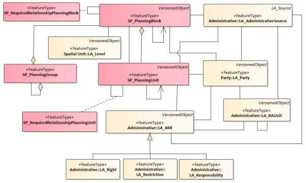
In order to prepare the LADM revision, two workshops were organized: 16-17 March 2017
   (Delft) and 11-13 April 2018 (Zagreb), with experts involved in the development of the initial
   version of LADM and representatives of all mentioned stakeholders. For the purpose of the
   revision, it is important to analyze and compare currently operational and proposed country
   profiles and their implementations of first version of LADM, ISO 19152:2012. FIG did submit
   a New Working Item Proposal to ISO on the development of LADM Edition II in May 2018.
   The proposal includes the following main scheduled LADM extensions:

   1. Extended scope of conceptual model. This includes valuation, SDG LA indicators,
      Performance Index, linking physical objects, indoor models, support to marine spaces,
      spatial planning/zoning with legal implications, other legal spaces: mining, archaeology,
      utilities;
   2. Improvement of current conceptual model. This includes formal semantics/ontology for
      LADM Code Lists; more explicit 3D+time profiles; an extended survey model and legal
      model;
   3. Encodings/technical models. This includes further integration with BIM/IFC, GML,
      CityGML, LandXML, LandInfra, IndoorGML, RDF/linked data, GeoJSON, and:
   4. Process models for: survey procedures, map updating, transactions – including blockchain.

   This paper will further report in the initial stage of the revision process where ISO/TC211 and
   OGC cooperate. First, an overview of the current developments in relation to the LADM
   standard is given in Section 2 of this paper. Then, the requirements for the development of
   Edition II are presented in Section 3, followed by an overview of some main new functionalities
   in Section 4. It should be noted that these are proposals and initial developments of the second
   edition of the model. The conclusions are provided in the last Section.

        2. OVERVIEW OF DEVELOPMENTS

   LADM – and also the STDM, the Social Tenure Domain Model are currently under
   implementation in several countries see FIG (2017) and FIG (2018a).

   LADM is applicable in relation to the implementation of relevant parts of the New Urban
   Agenda (UN, 2017), FAOs Voluntary Guidelines on the Responsible Governance of Tenure of
   Land, Fisheries and Forests in the Context of National Food Security (FAO, 2012) and the
   Continuum of Land Rights as from UN-Habitat (UN-Habitat, 2008, Teo and Lemmen, 2013).
   This fits of course very well into the context of implementation of the Sustainable
   Developments Goals.

    The Fit-For-Purpose approach in Land Administration (FIG/World Bank, 2014; UN-
    Habitat/GLTN/Kadaster, 2016) has been developed in reaction to the challenges set by the
    overall Global Agenda for Sustainable Development. The Fit-For-Purpose approach argues for
    cost-effective, time-efficient, transparent, scalable and participatory land administration,
Jointincluding
       ISO/TC211Participatory
                 and OGC Revision of the LADM:
                              Surveying,       ValuationLand
                                          Volunteered    Information, Spatial Planning
                                                              Administration           Information, SDG Land
                                                                                 and Crowdsourcing.     The
Indicators, Refined Survey Model, Links to BIM, Support of LA Processes, Technical Encodings, and Much More on
Their Way! (10079)
Peter van Oosterom, Abdullah Kara, Eftychia Kalogianni, Anna Shnaidman, Agung Indrajit and Abdullah Alattas
(Netherlands)
FIG Working Week 2019
Geospatial information for a smarter life and environmental resilience
Hanoi, Vietnam, April 22–26, 2019
principle of the Fit for Purpose approach is that the spatial, legal and institutional frameworks
for Land Administration are in balance in such a way that tenure security can be established
and maintained in a timely and affordable way, always aiming at the local, regional or national
needs. The introduction of the Fit for Purpose Land Administration can be considered a new
way of thinking in achieving faster, cheaper and more appropriate land administration systems
for the world. In order to assure an easy and adaptable interoperability layer with other
stakeholders, the Fit-For-Purpose Guiding Principles recommend the data model chosen for the
Fit-For-Purpose Land Administration system should be based on (ISO 19152:2012) LADM and
the derived STDM.
During the last two LADM Workshops, (FIG, 2017 and FIG, 2018a) held in Delft, The
Netherlands in 2017 (FIG, 2017) and in Zagreb, Croatia, 2018 (FIG, 2018a) the need for
extensions of the scope of the LADM standard and improvement of the LADM was identified.
The main outcomes of the workshops can be summarized as:
1. The New Working Item Proposal (NWIP), as submitted by FIG to the ISO Technical
Committee on Geographic Information (ISO TC 211), provides an overview of needs and
requirements discussed by international experts during LADM Workshops in Delft, in
March 2017 and in Zagreb in April 2018. The New Working Item Proposal has been
accepted by ISO TC 211 and there was a call for participants for the Stage 0 project on ISO
19152 LADM in September 2018.
2. ISO Stage 0 project started in May 2018 (during the 46th Plenary Meeting Week of TC 211
Copenhagen, Denmark), given the potential broad scope, including fiscal/valuation
extension module, more explicit semantics of code list values, further modelling LADM's
rights, restrictions, responsibilities (RRRs), further modelling of LADM's survey and spatial
representation, functionality for monitoring SDG Indicators (aggregated values at different
levels), 3D/4D Cadastre, inclusion of spatial planning/zoning with legal implications,
functionality in LADM in support of Marine Cadastre (esp. coastal zones), more explicit
relations with Building Information Modelling (BIM), new types of legal spaces: mining,
archaeology, utilities. Then, there was a first meeting in November 2018 in Wuhan, China,
during the 47th Plenary Meeting Week of TC 2111 on the approach and contents of the
LADM Edition II.
3. Collaboration with partners – see Section 1 of this paper, is crucial and mandatory during
the revision.
3. REQUIREMENTS FOR LADM EDITION II
The first edition of LADM should be upwards compatible with future editions. Future editions
may have an extended scope. LADM improvements and extensions are needed – as well as
LADM workflow/ process models. This section is based on the New Working Item Proposal as
submitted by FIG to ISO TC 211; see also Lemmen et al. (2018).
Joint1 https://committee.iso.org/sites/tc211/home/plenary-meeting/47th-plenary-meeting-china.html
ISO/TC211 and OGC Revision of the LADM: Valuation Information, Spatial Planning Information, SDG Land
Indicators, Refined Survey Model, Links to BIM, Support of LA Processes, Technical Encodings, and Much More on
Their Way! (10079)
Peter van Oosterom, Abdullah Kara, Eftychia Kalogianni, Anna Shnaidman, Agung Indrajit and Abdullah Alattas
(Netherlands)
FIG Working Week 2019
Geospatial information for a smarter life and environmental resilience
Hanoi, Vietnam, April 22–26, 20193.1 Scope
A proposal to extend the scope of LADM with a valuation perspective is available (Çağdaş et
al., 2016, Çağdaş et al., 2017). This proposal provides a data model that could be used to
construct information systems for immovable property valuation (as basis for taxation). The
proposal provides a common basis for governments to direct the development of local and
national databases, as well as for the private sector to develop information technology products.
The Global Land Indicators Initiative, see UN Habitat/GLTN, 2017 and also UN ECOSOC and
African Union, 2016, seeks to derive a list of globally comparable harmonized land indicators,
using existing monitoring mechanisms and data collection methods as a foundation.
Internationally agreed standards will be key alongside agreed global concepts and evidence-
based approaches. There is need for a foundation of a Land Administration Performance Index
– which is possible linked to existing global frameworks or initiatives.
Legal space and legal objects have its own geometry which is in many cases not (or not
completely) aligned with physical space and physical objects. Legal space should be linked to
physical objects – by IDs or re-use of descriptions of space. BIM/IFC and CityGML offer
options in this respect. The users of the indoor spaces create a relationship with the space
depending on the type of the building and the function of the spaces. Applying LADM allows
assigning rights, restrictions, and responsibilities to indoor spaces, which indicates the
accessible spaces for each type of user. An IndoorGML-LADM model is one example of
linking physical and legal objects. A normative reference to IHO S121 (Marine Limits and
Boundaries) based on the LADM principles needs to be included in ISO 19152.
Spatial planning/zoning with legal implications. In principle this is a matter of coding zones in
code tables (based on the local situations). It further implies integration of spatial planning and
land administration environment. Re-use of zones from spatial planning into restrictions to land
rights should be possible. Other legal spaces are related to mining, archaeology, utilities (2D or
3D).
3.2 Improvements to be included in LADM II
For the domain of land administration, the localization issue extends from language names to
the various organizations and institutions dealing with interests in land. Paasch et al. (2015) and
Stubkjær et al. (2018) propose code lists as a mean of internationalization by which the classes
of the LADM may be related to the jurisdiction concerned. The issue of code lists has been
addressed by the OGC as well, namely in terms of the document 17-050r1 Code List Manifesto
(Scarponcini, 2017). Metadata and tenure atlases are relevant in this context. Tenure atlases
provide overview on tenure systems and the level of recognition. This may include areas
without land markets and nature preservation etc.
There is a model for representation of legal space with a datatype allowing the representation
of volumes that are not completely closed. More functionality is required for a complete
Jointpartition
ISO/TC211 and OGCmore
of space: Revision of the3D+time
explicit LADM: Valuation
profiles.Information,
An extendedSpatial Planning
survey Information,
model and legalSDG Land
model
Indicators, Refined Survey Model, Links to BIM, Support of LA Processes, Technical Encodings, and Much More on
Their Way! (10079)
Peter van Oosterom, Abdullah Kara, Eftychia Kalogianni, Anna Shnaidman, Agung Indrajit and Abdullah Alattas
(Netherlands)
FIG Working Week 2019
Geospatial information for a smarter life and environmental resilience
Hanoi, Vietnam, April 22–26, 2019is needed. This implies adjustments from field observations to the spatial database and the
generation of quality labels. Encodings models concern the further detailed technical
specification of LADM based on existing standards: BIM/IFC, GML, CityGML, LandXML,
InfraGML, IndoorGML, RDF/linked data, GeoJSON. BIM is very important in order to
establish a link between BIM and land administration in relation to spatial planning and
lifecycles of constructions/ buildings. Open data is about Coding of Rights, Right holders,
Spatial Unit Types, etc. See Informative Annex J of LADM (ISO, 2012) – W3C.
3.3 Workflows and process models
Cadastral map updating includes adjustments and transformations of field observations
(collected at different moments in time and with different survey instruments or use of imagery
from different sources) to the spatial database. Management of areas is needed – there may be
more than one area to be maintained for the same spatial unit – the legal area and the accurate
area as calculated in the cadastral GIS. Implementation of tolerances to manage the differences
should be flexible and purpose related. Results of subdivisions of spatial units may need to be
shared with other systems. This includes results of readjustments and land consolidation.
Blockchain technology in transaction processes could be very well applicable for transactions
in land administration. Conversion of social tenure to legal tenure is a process that may require
different levels (layers) with related attributes. The same is valid for geometric quality
improvements of the cadastral map.
A new class representing processes may be defined: a specialization of the class representing
sources – thereby creating a connection between the classes of workflow management module
and LADM classes.
Processes can be organized on the basis of use of electronic signatures in case of applications
and information requests with public and private keys and encryption/decryption. Provision of
information to data collectors for initial data collection or maintenance is a specific but very
important process (task management, logistics).
New approaches in Land Administration include Volunteered Land Administration and
Crowdsourcing. It is possible that right holders and communities collect and maintain their own
data with a certain level of professional support for quality insurance etc. Participatory
surveying is possible with GPS. Conversion from social tenure to legal tenure may require
professional support – but it is easy to make this process complex and complex to make it easy.
The Publication of parties, related rights and spatial units also via global services (as may be
Google, Virtual Earth and Open Street Map and many others).
There will be a need for considerably more integration across the various national data and
information systems and platforms in order to leverage the most effective data and analysis for
evidence-based policy formulation and decision making. Image-based acquisition of cadastral
boundaries needs access to huge image libraries – including historical imagery – to support
Jointlarge-scale
ISO/TC211 implementations.
and OGC Revision of the LADM: Valuation Information, Spatial Planning Information, SDG Land
Indicators, Refined Survey Model, Links to BIM, Support of LA Processes, Technical Encodings, and Much More on
Their Way! (10079)
Peter van Oosterom, Abdullah Kara, Eftychia Kalogianni, Anna Shnaidman, Agung Indrajit and Abdullah Alattas
(Netherlands)
FIG Working Week 2019
Geospatial information for a smarter life and environmental resilience
Hanoi, Vietnam, April 22–26, 20194. PROPOSED NEW FUNCTIONALITY IN LADM EDITION II
In this section a number of initial proposals for new functionality is introduced. The following
new parts are include here: Valuation Information Model (Subsection 4.1), Spatial Planning
Information Model (Subsection 4.2), Refined Survey Model (Subsection 4.3), 3D Spatial
Profiles (Subsection 4.4), IndoorGML-LADM Combination (Subsection 4.5), and Processes
(Subsection 4.6).
4.1 Valuation Information Model
Classes in the Valuation Information Model Package (under development) get a prefix VM as
from Valuation Model. The main classes of the Valuation Information Model Package are: (1)
VM_ValuationUnit, (2) VM_ValuationUnitGroup, (3) VM_SpatialUnit, (4) VM_Building, (5)
VM_CondominiumUnit, (6) VM_Valuation, (7) VM_MassAppraisal (8)
VM_TransactionPrice, (9) VM_SalesStatistic, and (10) VM_ValuationSource, see Figure 1.
class Valuation Package
VersionedObject «featureType»
«featureType» Valuation::
Valuation::VM_Valuation VM_MassAppraisal
VersionedObject VersionedObject VersionedObject
LA_Source
«featureType» «featureType» «featureType» «featureType»
Valuation:: Valuation:: Valuation:: Valuation::
VM_ValuationSource VM_TransactionPrice VM_SalesStatistic VM_ValuationUnitGroup
VersionedObject
«featureType»
Valuation::
VM_ValuationUnit
VersionedObject VersionedObject VersionedObject
«featureType» «featureType» «featureType»
Valuation:: Valuation::VM_Building Valuation::
VM_SpatialUnit VM_CondominiumUnit
Figure 1 — Classes of Valuation Package
Valuation Units, as instances of VM_ValuationUnit, are the basic recording units of valuation
registries, and realized by an aggregation relationship of VM_ValuationUnit onto itself, see
Figure 1. The object of valuation may be (a) only land (e.g. cadastral parcel), (b) only
improvements (e.g. buildings), (c) land and improvements together as land property, (d) land
and improvements together as condominium property (McCluskey, 1999; Bird and Slack, 2002;
Almy, 2014)
Joint ISO/TC211 and OGC Revision of the LADM: Valuation Information, Spatial Planning Information, SDG Land
Indicators, Refined Survey Model, Links to BIM, Support of LA Processes, Technical Encodings, and Much More on
Their Way! (10079)
Peter van Oosterom, Abdullah Kara, Eftychia Kalogianni, Anna Shnaidman, Agung Indrajit and Abdullah Alattas
(Netherlands)
FIG Working Week 2019
Geospatial information for a smarter life and environmental resilience
Hanoi, Vietnam, April 22–26, 2019Valuation Units may be grouped as valuation unit groups, as instances of class VM_ValuationUnitGroup, and realized by an aggregation relationship of VM_ValuationUnitGroup onto itself, see Figure 1. A valuation unit group may be a grouping of other valuation unit groups. Examples of valuation units may be grouped according to zones (e.g. administrative divisions, market zones) that have similar environmental and economic characteristics, or functions of valuation units (e.g., commercial, residential, agricultural) that have similar physical characteristics. Class VM_SpatialUnit represents for example cadastral parcels, as well as sub-parcels that are subjects to valuation activities. VM_SpatialUnit is a specialization class of LA_SpatialUnit. Building represent physical spaces of buildings, building parts, other constructions, and their characteristics in valuation activities. A building may be considered as complementary parts of parcels (VM_SpatialUnit), but may be valued separately from the parcels on which they are located. This class coincides with the physical space of a building. A condominium building contains condominium units established according to condominium schemes. This class is adopted from the OGCs LandInfra standard (OGC, 2016). A condominium building consists of (i) condominium units (e.g. apartments, shops); (ii) accessory parts assigned for exclusive use (e.g. garages, storage areas); (iii) and joint facilities covering parcel, structural components (e.g. foundations, roofs), accession areas (e.g. entrance halls, spaces), and other remaining areas of buildings (e.g. staircases, heating rooms) (Kara et al., 2018). Condominium units as instances of class VM_CondominiumUnit. A condominium unit is for the exclusive use of the individual condominium owner and shares a condominium building. Class VM_Valuation, as counterparts of ExtValuation external class of LADM, is to specify output data produced within valuation processes, especially for property tax assessment. It concerns date of valuation, value type, valuation approach, and assessed value of valuation units. Class VM_Valuation has a class as specification: Mass appraisal, as instances of class VM_MassAppraisal. Mass valuation is a process of valuing a group of valuation units using standardized procedures at a given date. Class VM_MassAppraisal describes mathematical models, mass appraisal analysis types (e.g., multiple regression analysis), and the sample size of the analysis. Transaction prices as instances of class VM_TransactionPrice. Class VM_TransactionPrice characterizes the information content of transaction contractor declarations, including the date of contract or declaration, transaction price, date and type of transaction (e.g., sale, heritage, forced sale, and rent prices). VM_SalesStatistic, with sales statistics as instances. It represents sales statistics produced through the analysis of transaction prices. VM_TransactionPrice and VM_SalesStatistic serve valuation activities for different requirements, e.g. estimating property values for property taxation, expropriations, and monitoring price trends. Valuation source as instances of class VM_ValuationSource. In principle, property valuation is based on a valuation source, as instances from class LA_ValuationSource. Joint ISO/TC211 and OGC Revision of the LADM: Valuation Information, Spatial Planning Information, SDG Land Indicators, Refined Survey Model, Links to BIM, Support of LA Processes, Technical Encodings, and Much More on Their Way! (10079) Peter van Oosterom, Abdullah Kara, Eftychia Kalogianni, Anna Shnaidman, Agung Indrajit and Abdullah Alattas (Netherlands) FIG Working Week 2019 Geospatial information for a smarter life and environmental resilience Hanoi, Vietnam, April 22–26, 2019
4.2 Spatial Planning Information Model

    It is common that countries to manage land tenure in a separate mechanism than spatial
    planning (Enemark 2004). International Federation of Surveyors (FIG) considers spatial
    plans are closely related with the cadastre as it may involve consultation and mediation
    processes in developing a new land use plan (FIG 1995). Extension of the standard is needed
    in developing an effective way to relate land tenure and spatial planning information.
    Standardization and harmonization of spatial planning information have been performed in
    Europeans countries through initiatives from each country, or a European wide, such as
    INSPIRE and multinational project, such as Plan4All (INSPIRE 2014, Murgante 2011, and
    Cerba et al. 2010). The standardization of spatial planning information in these initiatives
    mostly covered multiple layers spatial themes (e.g., land cover, land use, utilities, and
    government services, production and industrial facilities, agricultural and aquaculture
    facilities, regulation zones and reporting unit, and natural risk zones). Based on these ealier
    standardization efforts, the Valuation Information Model Package is now being development.
    The classes in this Package get a prefix SP as from Spatial Planning.

               Figure 2 — Classes of Spatial Planning Packages and its relation to LA Party
   The spatial planning information package consisting six classes: SP_PlanningBlock,
   SP_PlanningUnit, SP_PlanningGroup, SP_RequiredRelationshipPlanningBlock, and SP_
Joint ISO/TC211 and OGC Revision of the LADM: Valuation Information, Spatial Planning Information, SDG Land
   RequiredRelationshipPlanningUnit. This package also introduces an interfaceObject class in
Indicators, Refined Survey Model, Links to BIM, Support of LA Processes, Technical Encodings, and Much More on
Their Way! (10079)
Peter van Oosterom, Abdullah Kara, Eftychia Kalogianni, Anna Shnaidman, Agung Indrajit and Abdullah Alattas
(Netherlands)
FIG Working Week 2019
Geospatial information for a smarter life and environmental resilience
Hanoi, Vietnam, April 22–26, 2019
LA_SubBAUnit to accommodate sub-parcel division of RRRs from land administration and
spatial planning processes. Authors re-use existing LA classes as much as possible to maximize
the integration of spatial planning information into LADM (Fig 9). SP_PlanningBlock contains
spatial plan resulted from spatial planning processes. SP_PlanningGroup class accommodates
aggregation and hierarchy of spatial planning from all levels of spatial planning, namely
national plan, provincial plan, and city/municipality plan. In reality, SP_PlanningBlock is
represented by a spatial plan map while SP_PlanningUnit is referring to zoning map (Fig. 9).
Instance of SP_PlanningGroup is to accommodate hierarchy in spatial planning, such as (a)
regional-wide (e.g., European Union), (b) Country-wide (e.g., Indonesia), (c) Island, (d) State
or Province, (e) Municipality or City, and (f) Urban or Rural. The class SP_PlanningBlock has
an optional association class: SP_RequiredRelationshipPlanningBlock while The class
SP_PlanningUnit has an optional association class: SP_RequiredRelationshipPlanningUnit
(See Figure 2). The required relationships classes facilitate declaration of explicit spatial
relationships or criteria, such as to declare geometric quality (accuracy and precision) of a
geometry of the spatial information classes or to declare topology relationship between planning
blocks and land parcel.
Figure 3 — Classes of Spatial Planning Unit Sub-Package
Joint ISO/TC211 and OGC Revision of the LADM: Valuation Information, Spatial Planning Information, SDG Land
Indicators, Refined Survey Model, Links to BIM, Support of LA Processes, Technical Encodings, and Much More on
Their Way! (10079)
Peter van Oosterom, Abdullah Kara, Eftychia Kalogianni, Anna Shnaidman, Agung Indrajit and Abdullah Alattas
(Netherlands)
FIG Working Week 2019
Geospatial information for a smarter life and environmental resilience
Hanoi, Vietnam, April 22–26, 2019Both SP_PlanningBlock and SP_PlanningUnit reuse LA_BoundaryFace and
LA_BoundaryFaceString geometry to represent sectoral policies integration through spatial
planning processes (Fig 3). An instance of class LA_BoundaryFaceString accomodates a
boundary face string of spatial planning area. LA_BoundaryFaceString is also associated to
class LA_Point. Document related to geometry of spatial planning is contained in class
LA_SpatialSource. In the case of a location by text, a boundary face string would not be defined
by points. In case of a boundary face associated to a 3D planning unit, it can be described on
one or more spatial sources; see Fejl! Henvisningskilde ikke fundet. Fejl! Henvisningskilde
ikke fundet.. To accomodate multidimensional spatial planning, an instance of class
LA_BoundaryFace is a boundary face and VersionedObject accomodate 4D (3D+time)
representation for SP_PlanningUnit.
Figure 4 — Classes of Spatial Planning Administrative Sub-Package and its correlation with
LA_RRR
The Spatial Planning Package accommodates RRRs derived from spatial planning into LA
AdministrativeSource and LA_RRR. Administrative aspects of this package are basic classes
of SP_PlanningUnit and SP_PlanningBlock (see Figure 4). LA_AdministrativeSource
facilitates the foundation for rights, restrictions, and responsibilities derived from the spatial
planning process. Class SP_RequiredRelationshipPlanningUnit allows for creating instances of
relationships between SP_PlanningUnits. The RequiredRelationships classes are similar to
BAUnit, which can be legal, temporal, or of spatial nature. An instance of the class
SP_PlanningUnit registers a zoning unit which may contain RRRs derived from spatial
planning processes. These classes are based on an administrative source; an instance from class
SP_AdministrativeSource (see Figure 4). There is a unique combination between an instance
JointofISO/TC211 andanOGC
LA_Party, Revisionofofathe
instance LADM: of
subclass Valuation
LA_RRR,Information,
and anSpatial Planning
instance Information, SDG Land
of SP_PlanningUnit to
Indicators, Refined Survey Model, Links to BIM, Support of LA Processes, Technical Encodings, and Much More on
Their Way! (10079)
Peter van Oosterom, Abdullah Kara, Eftychia Kalogianni, Anna Shnaidman, Agung Indrajit and Abdullah Alattas
(Netherlands)
FIG Working Week 2019
Geospatial information for a smarter life and environmental resilience
Hanoi, Vietnam, April 22–26, 2019preserve the uniqueness of RRR for each SP_PlanningUnit. Both SP_PlanningUnit and
SP_AdministrativeSource are related to LA_RRR representing the integration of RRR derived
from spatial planning and land administration
4.3 Refined Survey Model
LADM refers to Observations and Measurement Standard (ISO, 2011), but in a very generic
form therefore, a refined model for different survey techniques is required. In order to form a
survey model an extended LA_SpatialSource class is suggested (Figure 5). New attributes have
been introduced and complimentary Code Lists added, see Figure 6.
A new optional association class was created to connect LA_Party and LA_SpatialSource. The
purpose of this association class is to denote the different roles of a survey executor that are not
explicitly covered by role attribute in the LA_Party class. A new Code List for the surveyParty
is also added.
Furthermore, a new association between the Administrative and the Spatial classes is suggested.
The associations functions as an integrated source. 0 represents a case of a pure Administrative
or Spatial source, whereas 1 illustrates a situation where a document contains both types of
information.
Figure 5 — Extended LA_SpatialSource Class
Joint ISO/TC211 and OGC Revision of the LADM: Valuation Information, Spatial Planning Information, SDG Land
Indicators, Refined Survey Model, Links to BIM, Support of LA Processes, Technical Encodings, and Much More on
Their Way! (10079)
Peter van Oosterom, Abdullah Kara, Eftychia Kalogianni, Anna Shnaidman, Agung Indrajit and Abdullah Alattas
(Netherlands)
FIG Working Week 2019
Geospatial information for a smarter life and environmental resilience
Hanoi, Vietnam, April 22–26, 2019Figure 6 — Code List for extended LA_SpatialSource
4.4 3D Spatial Profiles
The level of geometric encoding as defined in ISO19152 provides a framework for
categorization of spatial units recorded in a cadastre or other land administration organizations,
ranging from “text based” spatial unit to the “topology based” encoding (both 2D and 3D). The
initial classification of 3D spatial units was provided by Thompson et al. (2015) and forms the
starting point for further investigation. The defined spatial units’ categories (FIG, 2018b;
Thompson et al., 2016) are listed below in an order of growing complexity (Kalogianni et al.,
2018):
I. 2D spatial unit: completely defined by the 2D location of points along its boundary. 2D
spatial units are the most common in most jurisdictions and they actually implying 3D
spatial units which have no explicitly defined bounded surfaces, as they actually define a
prism, column of space above and below the land surface (Stoter and van Oosterom,
2006).
II. 3D spatial unit: defined by a set of bounding faces, which are themselves defined by a set
of 3D points and an interpretation. The following subcategories are defined for the 3D
spatial unit:
• Semi-open spatial unit: defined by a 2D shape with one horizontal surface (upper or
lower surface) – e.g. “to the depth of …meters”. Semi-open spatial units are also
common and very simple to store and to visualize in 2D.
• Polygonal slice spatial unit: defined by 2D shape with horizontal bounded surfaces
(upper and lower surface), it is the most common form of closed 3D spatial unit.
Individually, the units that lie in this category are easy to visualize and store.
For both categories, semi-open spatial unit and polygonal slice spatial unit, the
Joint ISO/TC211 and OGCsubcategories
following Revision of the LADM: Valuation
depending on theInformation, Spatial
nature of the Planning
surface Information,
definitions areSDG Land
defined:
Indicators, Refined Survey Model, Links to BIM, Support of LA Processes, Technical Encodings, and Much More on
Their Way! (10079)
Peter van Oosterom, Abdullah Kara, Eftychia Kalogianni, Anna Shnaidman, Agung Indrajit and Abdullah Alattas
(Netherlands)
FIG Working Week 2019
Geospatial information for a smarter life and environmental resilience
Hanoi, Vietnam, April 22–26, 2019˗ Above/below an elevation: the surface is defined by a horizontal flat plane at a
height above/below a datum.
˗ Above/below a surface parallel to the local ground surface, and a defined distance
above/below it.
• Single-valued stepped spatial unit: (Fejl! Henvisningskilde ikke fundet. 7C) defined
by only horizontal and vertical boundaries, but non self-overlapping in z (i.e. at any
location x, y there is only a single range of z values that belong to spatial units);
• Multi-valued stepped spatial unit: (Fejl! Henvisningskilde ikke fundet. Fejl!
Henvisningskilde ikke fundet.) defined by a set of boundary faces, all of which are
all either horizontal or vertical, without a restriction of the volume to being single
valued in z. This allows volumes with “caves” or “tunnels” in the wall.;
• General 3D spatial unit: (Fejl! Henvisningskilde ikke fundet. Fejl!
Henvisningskilde ikke fundet.) it is the “catch-all” category of spatial units, which
fail to fit in one of the above categories. It is defined in part by boundaries other than
horizontal and vertical and thus at its definition at least one boundary should be
defined by one non-horizontal, or non-vertical face. This category may result to a
further categorization of this class as the following boundaries lie in this category: 2-
manifold, planar/curved boundaries, open/closed volume, single/multi- volume. It
should be considered whether the sub-categories that will be created would be mutual
exclusive, or would they be independent aspects and generate multiple categories form
their possible combinations.
• Building/construction format spatial unit: (Fejl! Henvisningskilde ikke fundet. 7A)
legally defined by the extents of an existing or planned structure that contains/will
contain the unit. In the case that some jurisdictions decide not to record the geometry
at this category, then it can be a 3D spatial unit with a “text-based” description, while
for the rest that do describe the geometry, this category behaves like other 3D spatial
units (usually polygon slice). The decision to record or not the geometry is purely
local and could be applied to any type of spatial unit.
• Any of these 3D Spatial Units can give rise to a Balance spatial unit: It can be of any
complexity as above but represents the remainder of a 2D spatial unit (i.e. prism) when
all the 3D spatial units defined within it have been excised. The remainder (inner 3D
region) could be of any complexity, but there are two variants of what this construct
means:
˗ The volume may be a primary interest excised from the 2D spatial unit (to avoid
overlap);
˗ The volume may define a secondary interest (e.g. lease, where overlap is
allowed), therefore leaving the base spatial unit as a standard 2D spatial unit.
In the case where 3D spatial units are modelled by a 3D geometry collection
(polyhedra), within a 2D surface parcel, then the "Balance space unit" is the unit
which comes as a result from prism - (minus) polyhedron. If the whole 3D domain is
modelled as space partition using a 3D topology structure, then the "Balance space
unit" will be a prism on the outside, with holes or caves made by the 3D geometries.
Joint ISO/TC211 and OGC Revision of the LADM: Valuation Information, Spatial Planning Information, SDG Land
Indicators, Refined Survey Model, Links to BIM, Support of LA Processes, Technical Encodings, and Much More on
Their Way! (10079)
Peter van Oosterom, Abdullah Kara, Eftychia Kalogianni, Anna Shnaidman, Agung Indrajit and Abdullah Alattas
(Netherlands)
FIG Working Week 2019
Geospatial information for a smarter life and environmental resilience
Hanoi, Vietnam, April 22–26, 2019Figure 7 — Subcategories of spatial unit geometries: A. Building Format spatial units; B.
Simple Slice; C. Single-valued stepped spatial unit; D. Multi-valued stepped slice (“EMT G”
forms a “cave”); E. General 3D spatial unit (Kalogianni et al., 2018)
4.5 IndoorGML-LADM Combination
RRRs inside buildings are needed to support indoor navigation by managing the access and use
of space for each party. The party of the indoor spaces establishes a relationship with the spaces
according to the type of building and the function of the spaces. The party requires guidance in
some buildings to reach their destination, and, thus, several navigation models have been
developed for this purpose; however, these models do not distinguish between party types and
how that could affect their accessibility rights. Therefore, the integration of LADM and
IndoorGML allows assigning rights, restrictions, and responsibilities to each indoor space to
determine the accessible spaces for each type of party. By representing the party types of the
indoor spaces, LADM could establish a relationship between the indoor spaces and the party.
As a result, the navigation process will be more convenient and more straightforward because
the navigation route will avoid non-accessible spaces based on the rights of the party (Alattas
et al., 2017). The combined use of IndoorGML and LADM covers a broad range of information
classes: (indoor 3D) cell spaces, connectivity, spatial units/boundaries, (access/use) rights and
restrictions, parties/persons/actors, and groups of them. The integration model of LADM and
IndoorGML is part of a broad hierarchical framework of models for space subdivision based
on RRRs of the party as shown in Figure 8.
Joint ISO/TC211 and OGC Revision of the LADM: Valuation Information, Spatial Planning Information, SDG Land
Indicators, Refined Survey Model, Links to BIM, Support of LA Processes, Technical Encodings, and Much More on
Their Way! (10079)
Peter van Oosterom, Abdullah Kara, Eftychia Kalogianni, Anna Shnaidman, Agung Indrajit and Abdullah Alattas
(Netherlands)
FIG Working Week 2019
Geospatial information for a smarter life and environmental resilience
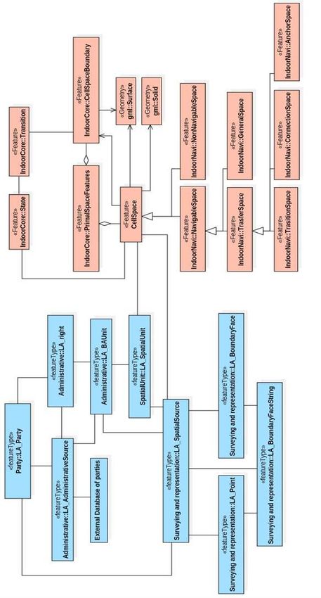
Hanoi, Vietnam, April 22–26, 2019Figure 8 — Hierarchical framework of integration model (Alattas et al., 2018). IndoorGML is an OGC standard that provides information of the indoor space and GML syntax for encoding geoinformation for the purpose of navigation (Alattas et al., 2018). IndoorGML determines a model to describe the geometry, topology and semantics of the indoor spaces that are utilized for the components of navigation routes. There are two categories based on the indoor spatial applications: 1) managing the building components and facilities, and 2) using the indoor space. The first category mainly focuses on the architecture elements of the building such as walls and roofs (discipline is called FM, facility management). The second category deals with the use and localization features of the indoor space, which leads to describing spaces such as rooms, corridors, and constraints elements such as doors. IndoorGML establishes a framework to determine static or mobile objects (agents) and provide spatial information services (navigation) by utilizing their positions in indoor space. IndoorGML represents the spatial character of the indoor spaces and provides information about their connectivity [Alattas et al., 2018b]. It has four different type of classes (GML, IndoorCore, IndoorNavi, and Not implemented) (Alattas et al., 2018). The combined UML model of IndoorGML and LADM is shown in Figure 9. Note the main links between these two models is via CellSpace (at the IndoorGML side) and LA_SpatialUnit/ LA_SpatialSource (at the LADM side). Joint ISO/TC211 and OGC Revision of the LADM: Valuation Information, Spatial Planning Information, SDG Land Indicators, Refined Survey Model, Links to BIM, Support of LA Processes, Technical Encodings, and Much More on Their Way! (10079) Peter van Oosterom, Abdullah Kara, Eftychia Kalogianni, Anna Shnaidman, Agung Indrajit and Abdullah Alattas (Netherlands) FIG Working Week 2019 Geospatial information for a smarter life and environmental resilience Hanoi, Vietnam, April 22–26, 2019
Figure 9 — UML model of LADM-IndoorGML combined model, the LADM classes are in blue
Joint ISO/TC211 and OGC Revision of the LADM:classes
                          and IndoorGML       Valuation
                                                     areInformation, Spatial Planning Information, SDG Land
                                                         in coral IndoorGML
Indicators, Refined Survey Model, Links to BIM, Support of LA Processes, Technical Encodings, and Much More on
Their Way! (10079)
Peter van Oosterom, Abdullah Kara, Eftychia Kalogianni, Anna Shnaidman, Agung Indrajit and Abdullah Alattas
(Netherlands)
FIG Working Week 2019
Geospatial information for a smarter life and environmental resilience
Hanoi, Vietnam, April 22–26, 2019
4.6 Processes
The LADM conceptual information model is completed by a model describing the various
process. The LADM processes are organized per package and cover both data input and output.
First, the processes related to the core LADM packages: Party, Administrative and Spatial Unit
are described; second, the processes of the supplementary packages: Valuation and Spatial
Planning are outlined.
Each process encompasses principle components and forms the legal or spatial correlation
between them. Each element can be cross-connected to a corresponding LADM Class as
demonstrated below.
▪ The interested party or the initiator of the process, might also be referred to as
“stakeholder”, that may be a person or an organization, such as: right holder, entrepreneur,
municipality, government or an architect. This element of the process is denoted by the class
LA_Party.
▪ The executing party – licensed professionals or commoners who carry out the process, such
as: surveyor, volunteer etc. The LADM class of this element is LA_Party.
▪ The supervising or the inspectorial authority certified to approve, audit and/or execute the
final step of a certain process. For example: land registrar, state surveyor, planning or tax
authority which are represented as LA_Party as well.
▪ The input and the output of a process, may those be legal (deed/title) or spatial (map)
products depend on the type of the process and can be represented by either LA_Source,
both spatial and administrative, or in some cases integrated sources, which are illustrated in
the model via the association between the two subclasses of the LA_Source class. Some
processes may include special units as their input/output and hence correspond to
LA_SpatialUnit.
▪ Format or a procedure of data exchange, submission or distribution required for the
process. For instance, the use of DXF files for a cadastral map or request for registry form.
These may be depicted by sources attributes such as mediaType.
▪ Legal basis: the laws, regulations and administrative guidelines relating to the process, may
be presented in LADM by the LA_AdministratievSource.
▪ The actions needed to be taken during the process, such as: selling, recording, surveying
etcetera.
▪ Timeframe, it is a common practice for a timeframe for each specific part of a particular
processes to be set by law or in a case of lack of regulatory basis to be agreed upon by all
the parties involved.
▪ Restrictions or constraints which are characteristic in a given process, may be formed as
constrains in the LADM model
The general methodology for process modelling is of a hierarchical nature. The suggested
framework consists of 4 steps – levels.
Joint ISO/TC211 and OGC Revision of the LADM: Valuation Information, Spatial Planning Information, SDG Land
Indicators, Refined Survey Model, Links to BIM, Support of LA Processes, Technical Encodings, and Much More on
Their Way! (10079)
Peter van Oosterom, Abdullah Kara, Eftychia Kalogianni, Anna Shnaidman, Agung Indrajit and Abdullah Alattas
(Netherlands)
FIG Working Week 2019
Geospatial information for a smarter life and environmental resilience
Hanoi, Vietnam, April 22–26, 2019▪ Level 1 – Identification of all the actors/elements involved in a process according to the
specified elements.
Note: the actors and/or the elements might differ from country to country subject to
enforced laws and accepted procedures.
▪ Level 2 – Identification of process phases, in other words groups or sub-processes
relating to a certain topic and provision of generic description.
▪ Level 3 – Identification of basic activities.
▪ Level 4 – Building of a model.
The first two levels may be depicted by use case diagrams, whereas Levels 3 and for can be
presented via activity and/or sequence diagrams.
5. CONCLUSION
A New Working Item Proposal for the development of a second Edition of the Land
Administration Domain Model has been submitted by the FIG to the ISO Technical Committee
211 on Geographic Information.
This paper will be the first in a series to be published in the next years on the provision of
overview of the developments and of the proposed functionality of the revised standard– in
order to keep the professional community informed and involved.
REFERENCES
− Alattas, A., Zlatanova, S., van Oosterom, PJ.M. and Li, K. (2018) Improved and More
Complete Conceptual Model for the Revision of IndoorGML (Short Paper). GIScience.
− Alattas, A., Zlatanova, S., Van Oosterom, P., Chatzinikolaou, E., Lemmen, C.H.J. and Li,
K.-J. (2017) Supporting Indoor Navigation Using Access Rights to Spaces Based on
Combined Use of IndoorGML and LADM Models. ISPRS International Journal of Geo-
Information, 6(12), 384. doi:10.3390/ijgi6120384
− Almy, R. (2014) Valuation and Assessment of Immovable Property. OECD Working
Papers on Fiscal Federalism
− Bird, R. M. and Slack, E. (2002) Land and Property Taxation: A Review. World Bank,
Washington, DC
− Çağdaş, V., Kara, A., Işikdağ, Ü., van Oosterom, P.J.M. and Lemmen, C.H.J. (2017) A
Knowledge Organization System for the Development of an ISO 19152:2012 LADM
Valuation Module. In: Proceedings of FIG working week 2017, 29 May - 2 June 2017,
Helsinki, Finland
− Çağdaş, V., Kara, A., van Oosterom, P., Lemmen, C.H.J., Isikdag, Umit., Kathmann, R. and
Stubkjaer, E. (2016) An initial design of ISO 19152:2012 LADM based valuation and
taxation data model. In: Proceedings of the 11th 3D Geoinfo conference, 20-21 October
2016, Athens, Greece. Peer reviewed Annals, Volume IV-2/W1 / edited by E. Dimopoulou
Joint ISO/TC211 and OGC Revision of the LADM: Valuation Information, Spatial Planning Information, SDG Land
and P. van Oosterom. ISPRS, 2016. ISSN: 2194-9050
Indicators, Refined Survey Model, Links to BIM, Support of LA Processes, Technical Encodings, and Much More on
Their Way! (10079)
Peter van Oosterom, Abdullah Kara, Eftychia Kalogianni, Anna Shnaidman, Agung Indrajit and Abdullah Alattas
(Netherlands)
FIG Working Week 2019
Geospatial information for a smarter life and environmental resilience
Hanoi, Vietnam, April 22–26, 2019− FAO (2012) Voluntary Guidelines on the Responsible Governance of Tenure of Land,
Fisheries and Forests in the Context of Food Security. FAO, Rome, Italy
− FIG (2018a) Proceedings 7th Land Administration Domain Workshop, Zagreb, Croatia, 11-
13 April 2018. Editors: Christiaan Lemmen, Peter van Oosterom & Elfriede Fendel. ISBN
978-87-92853-69-1. International Federation of Surveyors FIG, Copenhagen, Denmark
https://wiki.tudelft.nl/bin/view/Research/ISO19152/LADM2018Workshop
− FIG (2018b) Best Practices 3D Cadastres. Extended version. Editor: Peter van Oosterom.
ISBN 978-87-92853-64-6. International Federation of Surveyors FIG, Copenhagen,
Denmark http://www.fig.net/news/news_2018/04_FIGPub_3DCad.asp
− FIG (2017) Documentation of the 6th Land Administration Domain Workshop, Delft, The
Netherlands.https://wiki.tudelft.nl/bin/view/Research/ISO19152/LADM2017Workshop
− FIG/World Bank (2014) Fit-for-purpose land administration: Copenhagen, International
Federation of Surveyors (FIG), 2014. FIG publication 60, ISBN 978-87-92853-11-0.
− FIG (2012) Spatially Enabled Society. Joint publication of FIG-Task Force on Spatially
Enabled Society in cooperation with GSDI Association and with the support of Working
Group 3 of the PCGIAP. ISBN 978-87-90907-97-6
− FIG/GLTN (2010) The Social Tenure Domain Model. FIG publication no 52. ISBN 978-
87-90907-83-9
− ISO (2012). ISO 19152:2012. Geographic information – Land Administration Domain
Model (LADM). International Organization for Standardization (ISO). Geneva,
Switzerland. https://www.iso.org/standard/51206.html
− ISO (2011) ISO 19156:2011, Geographic information — Observations and measurements.
International Organization for Standardization (ISO). Geneva, Switzerland
− Kara A., Cagdas V., Lemmen C., Iş ikdag U., van Oosterom P., Stubkjær E. (2018)
Supporting Fiscal Aspect of Land Administration through a LADM-based Valuation
İnformation Model. 2018 World Bank Conference on Land and Poverty, The World Bank
- Washington DC, March 19-23, 2018
− Kaufmann, J. and Steudler, D., (1998). Cadastre 2014. A vision for a future cadastral
system. FIG XXI International Congress. Brighton, United Kingdom
− Kalogianni, E., Dimopoulou, E., Thompson R., Lemmen, C.H.J. and van Oosterom, P.J.M.
(2018). Investigating 3D spatial unit’s as basis for refined 3D spatial profiles in the context
of LADM revision, 6th International FIG 3D Cadastre Workshop 2018, 177-200
− Lemmen, C.H.J., van Oosterom, P.J.M. and Kalantari, M. (2018) Towards a New Working
Item Proposal for Edition II of LADM. In: Proceedings of the 7th International FIG
Workshop on the Land Administration Domain Model 11-13 April 2018, Zagreb, Croatia,
International Federation of Surveyors, Copenhagen, Denmark. 331 – 354
https://wiki.tudelft.nl/pub/Research/ISO19152/LADM2018Workshop/21-
22_LADM_2018.pdf
− Lemmen, C.H.J. (2012) A domain model for land administration. Delft, Technical
University Delft (TUD), University of Twente Faculty of Geo-Information and Earth
Observation (ITC), 2012. ITC Dissertation 210, ISBN 978-90-77029-31-2
− McCluskey, W.J. (1999) Comparative Property Tax Systems: An International
Comparative Review. Aldershot, UK: Avebury Publishing Limited
Joint ISO/TC211 and OGC Revision of the LADM: Valuation Information, Spatial Planning Information, SDG Land
Indicators, Refined Survey Model, Links to BIM, Support of LA Processes, Technical Encodings, and Much More on
Their Way! (10079)
Peter van Oosterom, Abdullah Kara, Eftychia Kalogianni, Anna Shnaidman, Agung Indrajit and Abdullah Alattas
(Netherlands)
FIG Working Week 2019
Geospatial information for a smarter life and environmental resilience
Hanoi, Vietnam, April 22–26, 2019− OGC (2016). OGC Land and Infrastructure Conceptual Model Standard (LandInfra).
(Version 1.0, Publication Date: 2016-12-20), Editor: Paul Scarponcini, Contributors:
HansChristoph Gruler (Survey), Erik Stubkjær (Land), Peter Axelsson, Lars Wikstrom
(Rail).
− Paasch, J.M., van Oosterom, P.J.M., Lemmen, C.H.J. and Paulsson, J. (2015) Further
modelling of LADM's rights, restrictions and responsibilities (RRRs). In: Land use policy,
49(2015) pp. 680-689. Paasch, J.M., van Oosterom, P.J.M., Lemmen, C.H.J. and Paulsson,
J. (2015) Further modelling of LADM's rights, restrictions and responsibilities (RRRs). In:
Land use policy, 49(2015)
− Stoter, J.; van Oosterom, P.J.M. (2006). 3D Cadastre in an International Context. Boca
Raton FL, Taylor & Francis.
− Scarponcini, P. (2017). Code List Manifesto. OGC Pending document, 17-050r1, 2017-09-
04. Stubkjær, E., Scarponcini, P. (2017). Harmonization of standards - The ISO 19152:2012
LADM-family. OGC March '17 Technical and Planning Committee Meeting - Delft, the
Netherlands. Land Admin DWG, 2017-03-21.
− Stubkjær, E., Paasch, J.M., Çağdaş, V., van Oosterom, P.J.M., Simmons, S., Paulsson, J.
and Lemmen, C.H.J. (2018) International Code List Management – The Case of Land
Administration. In: Proceedings of the 7th International FIG Workshop on the Land
Administration Domain Model 11-13 April 2018, Zagreb, Croatia, International Federation
of Surveyors, Copenhagen, Denmark. Pages 223 – 244
https://wiki.tudelft.nl/pub/Research/ISO19152/LADM2018Workshop/15-
05_LADM_2018.pdf
− Teo, C. and Lemmen, C.H.J. (2013) The LADM and the continuum of land rights. In:
Proceedings of the 5th Land Administration Domain Model workshop, 24-25 September
2013, Kuala Lumpur, Malaysia
− Thompson, R., van Oosterom, P.J.M., Soon, K.H. and Priebbenow, R. (2016) A Conceptual
Model supporting a range of 3D parcel representations through all stages: Data Capture,
Transfer and Storage. In: FIG Working Week 2016 – Recovery from Disaster, Christchurch,
New Zealand, May 2-6
− Thompson, R., van Oosterom, P.J.M., Karki, S. and Cowie, B. (2015) A Taxonomy of
Spatial Units in a Mixed 2D and 3D Cadastral Database. FIG Working Week 2015
− UN (2017). A/RES/71/256 New Urban Agenda. ISBN: 978-92-1-132731-1
− UN ECOSOC and African Union,(2016). Facing the Challenges of Land Monitoring in the
Framework and Guidelines on Land Policy in Africa – Towards Agenda 2063 and the 2030
Agenda for Sustainable Development. https://repository.uneca.org/handle/10855/23503
− UN Habitat/GLTN (2017) Sourcebook for Operationalisation of Global Land Indicators.
Global Land Indicators Initiative (GLII) Working Paper Number 4. Nairobi.
http://mirror.gltn.net/index.php/land-tools/gltn-land-tools/global-land-indicators-initiative-
glii
− UN Habitat/GLTN/Kadaster (2016) Fit-for-purpose land administration: guiding principles
for country implementation: e-book. Nairobi, United Nations Human Settlements
Programme (UN-HABITAT), 2016
− UN-HABITAT, (2008) Secure land rights for all. Nairobi, Kenya, United Nations Human
Joint ISO/TC211 and OGC
Settlements Revision of40thep.LADM: Valuation Information, Spatial Planning Information, SDG Land
Programme:
Indicators, Refined Survey Model, Links to BIM, Support of LA Processes, Technical Encodings, and Much More on
Their Way! (10079)
Peter van Oosterom, Abdullah Kara, Eftychia Kalogianni, Anna Shnaidman, Agung Indrajit and Abdullah Alattas
(Netherlands)
FIG Working Week 2019
Geospatial information for a smarter life and environmental resilience
Hanoi, Vietnam, April 22–26, 2019You can also read


