A Tool for Better Land Management - Article - MDPI
←
→
Page content transcription
If your browser does not render page correctly, please read the page content below
information
Article
A Tool for Better Land Management
Bernardo Carvalhinho 1 , Rodrigo Rocha Silva 2,3 and Jorge Bernardino 1,3, *
 1    Polytechnic of Coimbra—Coimbra Institute of Engineering (ISEC), 3030-190 Coimbra, Portugal;
      a21270434@isec.pt
 2    FATEC Mogi das Cruzes, São Paulo Technological College, Mogi das Cruzes 08773-600, Brazil;
      rrochas@dei.uc.pt
 3    Centre of Informatics and Systems of University of Coimbra (CISUC), 3030-290 Coimbra, Portugal
 *    Correspondence: jorge@isec.pt

 Received: 5 October 2020; Accepted: 24 November 2020; Published: 27 November 2020

 Abstract: The ability of keeping a record of geospatial information, knowing how it changed over
 time, is crucial for landscape analysis and territorial government. Land management is still a problem.
 Many governmental databases are incomplete, and there is a lack of reliable information. Good land
 management implies having a tool that can keep track of all the information available about a certain
 property and its changes over time. In this paper, we propose a land management tool where
 managers access all the information on a certain parcel of land—its boundaries, the land registration,
 a map which verifies the landcover, and the historic of updates of territorial limits. With the proposed
 tool, it is possible to edit the information of any property, whether it is active or not—that is, to also
 edit properties that no longer exist today, but that the user wants to add information to, for legal or
 other reasons. Keeping track of data properties’ revision history is groundbreaking due to the fact it
 is not well developed in existing tools. We will look at Brazil as a use case, where land management
 is a critical problem.

 Keywords: spatial data; property history; temporal GIS; GIS property registration system;
 GIS historical land management

1. Introduction
     The information technology facilitates the development of land use systems based on the simulation
of dynamic land use interactive processes [1]. There is also an increasing use of geoinformatics in
the design of geoinformation systems and decision support systems for realizing sustainable land
management at different scales and for specific user groups (land registry specialist, land analyst,
and field inspector). A digital geoinformation infrastructure and policy framework is emerging for this
purpose at global, regional, national, and local levels, as stated by Beek [2].
     Consequently, land management is essential for governments and companies for keeping control
of updated historical information [3]. The control of all transactions in which a property may be
involved, regularization of irregular settlements and the titling of its occupants are some relevant
examples. The problem is that many governmental databases are incomplete and do not contain
reliable information. In addition, many of the databases do not follow the evolution of properties
over time, keeping track of the data revision history and that does not allow the edition of historical
spatial data.
     As an example of this poor management, we used the use case of Brazil, where this problem
is grave. The landowners spend a lot of time and money on registering and licensing as required
by law. Normally a pile of papers and a large stack of information are required for each property.
Consequently, landowners and municipal managers need a better way to make the system work to
effectively manage the land.

Information 2020, 11, 0554; doi:10.3390/info11120554                        www.mdpi.com/journal/information
Information 2020, 11, 0554                                                                           2 of 17

      In Brazil, there is still the problem of false documentation. This occurs due to the deficiencies
found in the land control system, where, despite the various proposals, the government has not yet
implemented a single land registry or at least a specific register for large properties. There is also
no articulation and cross-checking of data between land agencies at the three levels of government
(federal, state, and municipal). Furthermore, there are “paper lands”, i.e., properties that exist only in
paper, and false documentation properties size is bigger than the dimension of the Amazon itself [4].
      Land grabbing has become a priority topic in academic research, and a political concern, due to
interests in the dynamics of the phenomenon and its negative impact on the sustainable development
of agriculture in rural areas [5]. Land grabbing is usually associated with other crimes [6]. The use of
gunmen to evict former owners and/or protect themselves from possible invaders is quite common,
as is the use of land for illegal extraction and criminal practices. There are families that have the right
to a certain land given by the Federal Constitution, but they continue to be exposed to the public policy
on Agrarian Reform, and the Federal Justice sentences to be carried out by public authorities. This case
of illegal possession by squatters is an additional issue in the history of conflicts that has been going on
for more than 15 years in the Mato Grosso region.
      The invasions are still a problem that persists today, causing losses. In Brazil there is a very large
amount of land that is invaded, and landowning companies need to carry out periodic inspections to
prevent invasions. The Brazilian courts determine that it is the obligation of the companies to carry out
such inspection. When a property with constructions is invaded, the process of building and managing
the losses is suspended until there is a court decision that guarantees the repossession of the property,
which can take weeks or months. For construction companies, the invasions involve more expenses.
These invasions also occur due to situations of poverty [7], where families that do not have places
to live invade public land, building inadequate housing in order to exercise its minimum housing
condition, with serious risks to sanitation, health, and safety.
      There is a study carried out in [8] that shows the mismanagement over the years of the land used
for the creation of dams and hydroelectric plants along the Tocantins River. The consequences caused
by dams are the most diverse, involving social and environmental cases, geophysical and hydrological
risks. Many of the dams built in Brazil did not consider relevant aspects, such as deforestation and
land expropriations. They were built in regions of native closed forests, many of them flooded areas of
fertile and agricultural land. Additionally, they caused the indigenous people to leave their homes
and lands because of the floods caused by dams. They were impacted by these constructions and
some promises those companies made them, which have never been fulfilled [9]. The use of our tool
makes possible to assist in this management by keeping everything in a complete database and with
information about all properties within any period.
      Another type of transaction that exists in the real estate world is expropriation, which is one of
the most serious resolutions used by governments to intervene in property law. In this case, the state
takes a certain good in a compulsory way for reasons of public interest (utility, public need or social
interest), causing its owner to lose the right to property, but normally paying fair compensation.
      Brazil is taken as a case study in this paper, but many other countries have similar problems of land
management [10–14]. The real estate world is full of problems and governments need help to maintain
all this material in a place where they can check all the information that a certain property has all its
history. Governments and companies need tools that help with the land management, as presented
in [15]. If governments pay attention to this aspect, it will be possible to avoid certain situations where
there is land that is not properly documented. There is unlawful occupation of land [16–20] in many
countries, such as South Africa, in which supposed owners take advantage of false documents, with the
appearance of being truthful, to seize public land or speculate for obtaining illicit advantages.
      Therefore, land management tools are not only geographic information systems as they represent
a legal lawfully meaningful relationship amongst people and between people and land. As the land
management activity on the one hand deals with huge amounts of data, which moreover are of a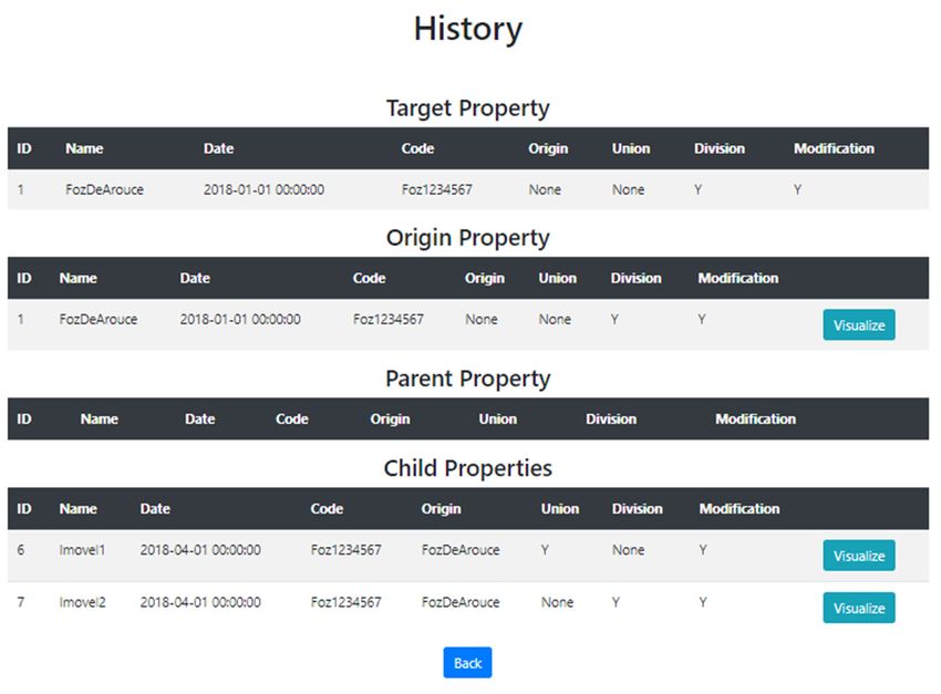
Information 2020, 11, 0554                                                                          3 of 17

very dynamic in nature, and on the other hand requires a continuous maintenance process, the role of
information technology is of strategic importance [21].
     In this work, we propose a tool that allows the edition of properties’ spatial data history, which it
is not well developed in existing tools. What is meant by property data history is how the property has
evolved over the years, since it was created and preserved all the modifications. Therefore, we can
have always in the database the details of all properties in any period, so that users can consult and/or
update this information.
     We present a new characteristic for property history—that is, the possibility of the edition of the
spatial data history, something that is not provided in the tools for better land management. The data
history edition is an important feature that enables governmental databases with all the historical
information about a certain property. In some cases, we have properties with incorrect data, such as
the property registration year. However, it is not be possible to alter such important information,
because today’s databases do not allow the user edit properties’ history. For example, we have a
property that existed in the year 2012 and, in that year, it suffered an invasion that was not reported.
If we want to report that invasion today it is not possible, because current tools do not allow the user
to manage historical data. Nevertheless, this control of properties history is groundbreaking since it
improves the precision and reliability of the database.
     Therefore, this work aims to build an application that offers the possibility to consolidate
and integrate a property database with environmental and cartographic data, using a Geographic
Information System (GIS) platform [22]. We use QGIS, which is a free and open source cross-platform
desktop geographic information system that supports viewing, editing, and analysis of geospatial
data [6]. The objective of this work is to optimize real estate management and facilitate access
to integrated data for the execution of inspection, invasion, complaints, and management of legal
processes involving properties. In this way, the main objective is to solve the problems of land
management, which is an evolving area and needs monitoring using digital technology. The system
was developed in the MVC architectural pattern using Python with the leaflet framework and QGIS.
To the best of our knowledge, there is no other methodology which allows the edition of historical
geospatial information.
     The remainder of this paper is organized as follows. In Section 2, we discuss related work on
land management. Section 3 describes the methodology used in this work, such as the data model,
the proposal for land history management problem, and an explanation about the Web application.
Section 4 reports the results of the land history and some examples from the Web application and
Section 5 discusses these results. Finally, Section 6 presents the conclusions and some ideas for
future work.

2. Related Work
      Practical tools which can help local users and multi-disciplinary teams work together on the
land management problem at the local to regional levels have emerged only very recently. In this
section, we present a summary of papers that focus on the land management problem and how to
solve this problem.
      Hans Hurni [23] review existing approaches for planning integrated land management vis à
vis the requirements set forth by the concept of sustainable land management as it emerged from
the UNCED process since the Rio conference in 1992, and propose appropriate conceptual and
methodological tools in response to these requirements. The author advocates that assessment tools
will require transdisciplinary methods that involve natural, social, and political sciences as well as
local knowledge systems. Additionally, according to Pieri [24], there is a need to move from concepts
and prescriptive approaches to an integrated approach to the physical planning and the social and
institutional dimensions of land management. A specific approach has been developed for this purpose,
which is called “sustainable development appraisal” (SDA). However, SDA is only a methodological
tool for the participatory assessment of sustainability from local to regional planning levels [25].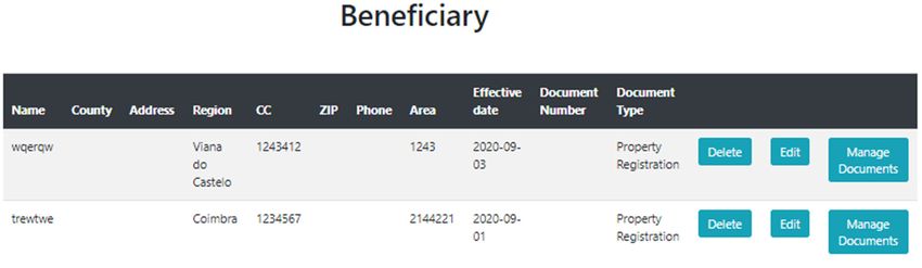
Information 2020, 11, 0554                                                                            4 of 17

      The authors Laskos, Cazella, and May Rebollar [26] denote that Brazilian rural spaces play an
important role in the management of environmental and social issues. Brazil has a property registration
system, but it is out of date and most of the information provided is not verified. This system also
leads to various frauds associated with tax payments, changes in ownership, etc. They suggest
the construction of a solid database to support management institutions and notaries so that it is
possible to carry out studies overtime on these same properties. Additionally, Thomson and Simpson’s
research [27] aims to investigate the role of historical farm management decisions in controlling the
utilization of grazing resources by domestic livestock under variable environmental conditions, and the
impact that these decisions have upon early farm viability and land degradation, using environmental
simulation modelling. The focus for these investigations is Iceland, as an example of a place where the
contemporary landscape has been extensively modified by grazing in the past. However, these works
only use simulation tools.
      Victorino, Amorim, and Shimabukuro [28] present the development of a WebSIG using PostgreSQL
in combination with PostGIS. This application allows the land registry to obtain information of
interest like consult the information about the owner, among other features. This paper also
presents the relationship entity diagram, to facilitate the understanding of the application’s behavior.
This application aims to maintain a reliable and updated register helping in decision-making, planning,
and municipal management. Although this work aims to present the main aspects involved in the
development of a system that helps information sharing between the territorial land registry and
property registry systems in small- and medium-sized municipalities, it does not deal with spatial
historical data.
      The authors in [29] discuss the importance of updating cadastral data, without losing the
historical data of the cadastral databases for town planning activity. They also present an experiment,
showing examples of using the database and the gvSIG tool, where through map visualization it is
possible to analyze the differences from the past to the present, but it does not allow changing any
information of the past data, as proposed in this work. The authors emphasize the lack of methods,
viable in terms of costs and benefit, mainly those that make possible the maintenance of data history
that has hindered significantly the planning activity, considering the importance of historical studies
for understanding certain facts that may point to future occurrences, which our work intends to solve.
      Francisco and Imai [30] mention the fact that there are still few works that discuss the representation
of information space, particularly regarding the changes that occurred in the urban area. For this,
they present an approach for the representation of the time–space of the land registry data used by
City Halls. This approach consists of maintaining the modifications, by overlapping and adding to
the object through versioning (storing the previous version) and this new version of the object is a
new instance that contains the inherited properties. Nevertheless, the proposal does not implement
interfaces that facilitate the use of applications for maintaining the geographic database, in order to
facilitate its use by users in daily operations.
      Toledo and Bertotti [31] present the development of a land management system (SIGEF) to
improve the land structure in Brazil. For this operation, the data entry is made from a spreadsheet,
which was duly prepared to carry out all the formatting rules required by SIGEF. This spreadsheet
is sent to SIGEF, where the server checks for errors. If the process is approved, the certification of
the property is immediate. The property map and the descriptive memory are created from the
system itself, automatically. The certification is subject to validation by the Real Estate Registry Office,
thus ending the process of certification of rural properties. The proposed system was at an early stage,
still with no practical results.
      Freitas and Lima [32] demonstrate the importance of GIS tools in the process of preparing
descriptive plans of the plots for the purpose of land tenure regularization in a community classified
as ZEIS (Space Areas of Social Interest) in Fortaleza, Brazil. The use of this tool allows obtaining a
better precision in the location of the parcels in the territory of the city, the mapping of accumulated
information, permitting a greater level of understanding the information contained in the database.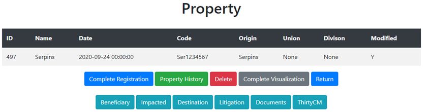
Information 2020, 11, 0554                                                                           5 of 17

The main contribution of this work was the introduction of spatial data in the database that contains
the cadastral socioeconomic information in order to support the ZEIS planning process.
     In [33], the authors present the case of Paraiba state, more specifically the municipality of Monteiro,
which does not have a reliable rural registry, which occurs many times in Brazil. For this project,
they use the ArcGIS tool and present the SHAPE attributes of Titled Lots. The filling of these lots was
based on technical materials that they obtained. Then they used an ESRI JavaScript API, so the data
could be viewed online without the need for specific software for visualization. This tool allows for a
faster dissemination of information, managing technical materials more effectively, and developing a
thematic map showing data properties before the certification process.
     Based on complete use of mature spatial information technologies and on land use and
management, Liang et al. [5] developed the Dingzhuang town information system of land resources
management based on spatial data. It provides land use and management with real-time information
and performs functions like property search map, map search function, visual inquiry of land
information and dynamic spatial graphic data. The basic functions of this system include land use
planning, basic farmland management, the management of land for construction use, land survey,
land registration and so on. Besides, it realizes the basic land management of each patch in the village
and town level, as well as property search map and map search function.
     Mondal et al. [21] present a study that develops a case study of land information system using
cadastral techniques of Tirat and Chalbalpur rural region of Raniganj in Barddhaman district of India,
which contains cadastral information. The final goal was to generate digital maps which will facilitate
land management and planning and in particular land registration and the issuance of land titles
in order to promote security of land tenure and reduce land disputes, such is the use case of Brazil,
used in our work.
     Recently, Mishra et al. [34] published a study based on remote sensing (RS) and geographic
information system (GIS) techniques, to monitor the changes in land use and land cover patterns
of Rani Khola watershed of Sikkim Himalaya for the periods 1988–1996, 1996–2008 and 2008–2017.
The result of this study reveals that the major land use in the watershed is forestry. Due to massive
afforestation program, declaration of Sikkim as organic state (2005), stringent law enforcement in
forestry sector and sustainable agroforestry systems the area under dense forest has increased by
16.4% between 1988 and 2017. This study utilizes the RS and GIS approach which is one of the
most prominent technology at present for spatio-temporal analysis. That is possible through other
conventional mapping techniques. The analysis and findings of the study have important policy
implications for the sustainable land-use/cover practices in the Sikkim Himalaya.
     Many of the aforementioned papers present an approach to poor land management, through the
use of GIS, to assist and improve the way in which information will be used and stored. However,
a few propose solutions for maintaining the property data history. Our work has these two objectives
combined, proposing a new approach to properties spatial data history manipulation using QGIS with
a Web application.

3. Methodology and Tools
     This section describes the methodology and the tools used for the creation of the Web application,
the database, and the proposal to deal with property data history. The creation of this Web application
was done using Python and Flask, a small web framework written in Python and based on the WSGI
Werkzeug library and the Jinja2 library. Flask has the flexibility of the Python programming language
and provides a simple model for web development). In order to view the properties on the Web,
Leaflet [35] was used, that is a JavaScript library specialized in visualizing geographic data on the Web.
     The database used for the application was PostgreSQL since the QGIS already has an extension
for this database. We also describe how the property history method works, and the lack of existing
proposals on the market to deal with this problem.
Information 2020, 11, 0554 6 of 17
In Figure 1 we can see the architecture of the tool. The Web application follows a normal
Model-View-Controller (MVC) structure. In the model, we can see some of the most important classes
Information 2020, 11, x FOR PEER REVIEW 6 of 17
of the Web application: Property, Beneficiary, etc. The model communicates with PostgreSQL to access
the data with
communicates and each taskwhere
QGIS, done by wethecan
usersee
is saved in the database. of
the representation The
thePostgreSQL
data in a database also
more informal way.
communicates with QGIS, where we can see the representation of the data in a more informal way.
All the actions that the user performs in QGIS are also saved in the database. The communication
All the actions that the user performs in QGIS are also saved in the database. The communication
betweenbetween
the Web the application andand
Web application QGIS
QGISisisvia thedatabase,
via the database, because
because when when a property
a property is in
is created created in
QGIS and QGISweandwant to visualize
we want to visualizeininthe webapplication,
the web application, first
first we wetohave
have save ittoinsave it in the
the database anddatabase
then and
access
then access theweb
the web application
application that
thatextracts the property
extracts data from
the property thefrom
data database.
the database.
Figure 1. Tool Architecture diagram.
Figure 1. Tool Architecture diagram.
3.1. Property History in Software Tools
3.1. PropertyOne of the problems that this work intends to solve is the edition of properties’ historical data.
History in Software Tools
The history of a property over time consists of knowing how it has evolved over the years since creation
Oneandofmaintaining
the problems the respective
that thisdetails
workofintends
the modifications.
to solve is In the
addition to being
edition able to maintain
of properties’ the
historical data.
historical data of the properties, it should also be possible to edit this
The history of a property over time consists of knowing how it has evolved over the years sincehistory, that is, it should be viable
to edit a property that no longer exists today, but that the user wants to add some information for
creation and maintaining the respective details of the modifications. In addition to being able to
example property registry date.
maintain theQGIS historical
is a free data of the
and open properties,
source GeographicitInformation
should also be possible
System to editthat
(GIS) application thiswas
history,
used to that is, it
should be viable
achieve the to edit afor
proposal property
the propertythathistory
no longer
problem. exists
We usetoday,
QGIS but thatis the
because one ofuser wants
the best toolstofor
add some
dealing with geographic data,
information for example property registry date.as described in [36]. One of our goals was to find one solution for the
QGISproperty history
is a free and problem using a tool
open source as good as the
Geographic commercial System
Information ones in the market
(GIS) (e.g., ArcGIS
application [37])was used
that
but without acquisition costs. ArcGIS is a GIS for working with maps and geographic information
to achieve the proposal for the property history problem. We use QGIS because is one of the best
maintained by the Environmental Systems Research Institute (ESRI). It is used for creating and using
tools formaps,
dealing with geographic
compiling geographic data, data, as described
analyzing in [36]. One
mapped information, of our
sharing goals
and was togeographic
discovering find one solution
for the property
information, history problem
using maps using a tool
and geographic as goodinasa the
information range commercial
of applications,ones andinmanaging
the market (e.g.,
ArcGIS geographic
[37]) but without
information acquisition
in a database.costs.
OtherArcGIS
platformsis awere
GIStested,
for working with [38]
such as gvSIG maps andand
Googlegeographic
Earth Pro [39] but they do not have the core functionalities of dividing
information maintained by the Environmental Systems Research Institute (ESRI). It is used for and joining properties.
QGIS was the best tool since it offers the divide and join functionalities under a simple and
creating and using maps, compiling geographic data, analyzing mapped information, sharing and
intuitive design. However, this platform did not have the ability to deal directly with the property
discovering geographic
historical data. Then,information,
to solve this problem,usingwemaps propose and geographic
a method using the information in a range of
existing functionalities.
applications,
QGIS hadandalready
managing geographictoinformation
the functionalities divide and joininproperties,
a database. Otherweplatforms
but when wereQGIS
edit a property tested, such
as gvSIGdoes
[38]notand
saveGoogle Earthversion,
the previous Pro [39] it isbut theyportraying
always do not have the version.
the same core functionalities
Therefore, by usingof dividing
the and
copy function
joining properties. given by QGIS we have a solution for saving historical property data.
The method for property history edition consists of the following: we have a property in the
QGIS was the best tool since it offers the divide and join functionalities under a simple and
database that we are going to edit, but we want to keep all the information of this property. In the
intuitiveQGIS
design. However,
tool, we this platform
select the property and createdida copy,
not have
whichthewill ability to deal added
be automatically directly with
to the the property
database.
historical
In data.
order toThen,
keep theto history,
solve this problem,
we will make ourwe propose
changes to theacopy
methodwhich,using the existing
after being edited, willfunctionalities.
be the
QGIS had already the functionalities to divide and join properties, but when we edit a property QGIS
does not save the previous version, it is always portraying the same version. Therefore, by using the
copy function given by QGIS we have a solution for saving historical property data.
The method for property history edition consists of the following: we have a property in the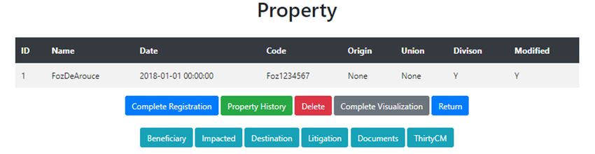
Information 2020, 11, 0554                                                                           7 of 17

most recent version of the property. If we want to make a division, we use a functionality offered by
QGIS that allows making cuts in the property. These cuts will give rise to new properties that have their
data equal to the property that originated them. If we want to make a join, we must select properties
that have intersecting parts (vertices or edges). The join is made through a functionality offered by
QGIS. The same happens with the division, the parameters must then be edited. By following these
steps, it is possible to maintain the property historical data over time without losing information.
     Through this method, we can maintain the history of a property over time. For distinguishing
these properties, the parent–child attributes, such as the creation date, will be used, or an attribute that
indicates which one is the parent property of the respective selected property.
     Nevertheless, the property history problem persists in the Web application. The divide and join
functionalities must be executed within QGIS since these two functions deal with editing the design of
the property. But all other actions involving the property must be kept in the database keeping the
history of the property. When we have a property and we want to associate a complaint (or other
action such as an invasion, beneficiary, impacted, inspection or litigation or make another transaction,
such as a purchase, sale, transfer, expropriation, purchase of installment, easement, regularization)
about that referred property, we have to follow the same idea described previously. We create a copy
of the property and this copy will have the same data as the previous property, but with the complaint
associated with this copy. In the Web application, users do not need to make a copy, because this action
will be done automatically by the application. With that, the user will know when the property had
the complaint and when it did not. The reasoning is the same as the division and join of properties.
We will always have the property history, whatever the change made in the property.
     This problem was partially solved by ArcGIS, another platform comparable to QGIS, and the
most used in this area. ArcGIS presents a solution called Archive [40] where it is possible to store
properties in a table as they change over time. The problem with this solution is that it does not allow
older properties to be edited. That is, if in the future we want to associate a document with a property
that no longer exists, it is not possible to do so. Actually, ArcGIS is the only tool that manages the
objective of the real estate history, despite not being completely efficient. The proposed solution allows
us to do what ArcGIS does, but with the possibility to edit older versions of the properties to achieve a
consistent database.
     The proposed tool is more complete than that of ArcGIS due to the fact that we can edit older
properties and associate any type of information with them and not just the most recent properties,
those that currently exist. Thus, it is possible to create a complete and reliable database.

3.2. Web Database
     In this section, we describe the database that is used in the Web application. Figure 2 illustrates
the entity–relationship model (or ER model). For readability reasons, this figure only shows the names
of tables but not its contents.
     The most important tables for the operation of the application are the following:
•    Beneficiary: This table represents each possible beneficiary in each transaction of a property.
     Each beneficiary may have a set of documents registered in the BeneficiaryDocument Table,
     where each record represents a document.
•    Litigation: This table stores each possible record of litigation or pre-litigation; the type of
     record is identified by a LitigationDegree field. A litigation can be generated from a complaint
     (Complaint Table), an inspection (Inspection Table) or an invasion (Invasion Table).
•    Destination: This table represents each possible transaction for a property. The validity of the
     registrations is determined by the ReferenceDate attribute. The parameter will be asked, so the
     user can compare it to the documents and see if the data matches.
•    PropertyDocument: This table represents each possible document of each property that is stored.
     Documents are associated by the registration number, but the system will display to the user,
     documents with previous or same registration date for the historic transaction of the property.
Through this method, we can maintain the history of a property over time. For distinguishing
these properties, the parent–child attributes, such as the creation date, will be used, or an attribute
that indicates which one is the parent property of the respective selected property.
Nevertheless, the property history problem persists in the Web application. The divide and join
functionalities must be executed within QGIS since these two functions deal with editing the design
Information 2020, 11, 0554 8 of 17
of the property. But all other actions involving the property must be kept in the database keeping the
history of the property. When we have a property and we want to associate a complaint (or other
•action such as an invasion, beneficiary,
TransactionDocument: impacted,each
This table represents inspection
possible ordocument
litigation orformake another transaction,
each property transaction.
suchThis
as atable
purchase, sale,
contains transfer, expropriation,
transaction-specific documentspurchase of installment,
that only make senseeasement,
when theregularization)
focus is on the
about that referred
details property, we
of the transaction. Thehave to follow
recent the same
documents thatidea described
are inherent topreviously.
the life cycle Weof create a copy
the property
of the property
will be storedandinthis
thecopy
tablewill have the same data as the previous property, but with the complaint
PropertyDocument.
•associated with this copy. In
Inspection: This table represents the Webeach application, users do not
possible inspection on need to make
a property; a copy,this
however, because this
table will
action will be done automatically by the application. With that, the user will know
not be used to register an inspection that the main occurrence is an invasion. Invasions are recorded when the property
had the complaint
directly in the and when
Invasion it didEach
Table. not.property
The reasoning
can have is the same inspection
several as the division andand
records joinanof inspection
properties.
We will always have the property history, whatever the change made in the
can have several actions. Each action of an inspection will be registered in the InspectionAction property.
This and
Table problem was partially
an inspection can havesolved by ArcGIS,
several documents another platform
registered in thecomparable to QGIS,Table
InspectionDocument andandthe
mostseveral
used inoccurrences
this area. ArcGIS presents a solution called
registered in InspectionOccurence Table. Archive [40] where it is possible to store
•properties
Property:in a table as they change
The Property over time. The
table represents eachproblem
possiblewith this solution
property is that itconsidering
registration, does not allow the
olderhistory.
properties to be edited. That is, if in the future we want to associate a document
Thus, for each new property or historical transaction a record is created. Each historical with a property
that transaction
no longer exists, it is notwill
of a property possible
be a row to do
in so.
theActually,
property ArcGIS
table. is the only tool that manages the
•objective of the real estate history, despite not
Impacted: This table represents each possible impact on each being completely efficient. The proposed
transaction solution
of a property.
allows
Eachus to do whatperson
impacted ArcGISmay does,havebutawith thedocuments
set of possibilityregistered
to edit older in versions of the properties
the ImpactedDocument to
Table;
achieve a consistent database.
each record will represent a document.
The proposed tool is more complete than that of ArcGIS due to the fact that we can edit older
• Invasion: This table stores each possible claim for a property, where each claim may have
properties and associate any type of information with them and not just the most recent properties,
a litigation or pre-litigation one (Litigation Table) and the type of record will be given by the
those that currently exist. Thus, it is possible to create a complete and reliable database.
LitigationDegree field. For each invasion, the registration of Invaders must take place and will be
stored in the Invader Table. The occurrences are also recorded in the InvasionOccurrence Table.
3.2. Web Database
• Complaint: This table stores each possible claim for a property. Each claim may have a litigation
In pre-litigation
or this section, we onedescribe theTable),
(Litigation database that is
the type ofused
record in will
the Web application.
be given Figure 2 illustrates
by the LitigationDegree field
the entity–relationship model (or ER
and each complaint is in the Complaint Table. model). For readability reasons, this figure only shows the
names of tables but not its contents.
Figure 2.
Figure 2. Entity–Relationship Data Model.
3.3. Web Application
This section describes how the Web application operates and the communication with QGIS
through the PostgreSQL database. The Web application was developed in Python + Flask and
Leaflet for viewing properties on the Web. In the application, it is where we optimize real estate
management, enabling access to integrated data for the execution of inspection, invasion, complaints,
and management of legal processes involving real estate. Thus, it is possible to associate the documents
with the properties, maintaining a useful land management, with all data stored in the database.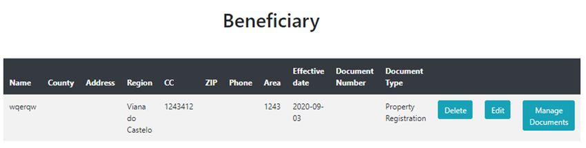
Information 2020, 11, 0554 9 of 17
The properties are created in QGIS, which are automatically saved in the database. When we
access the application, it is possible to perform various operations, since the completion of the
property registration or associate documents to properties (e.g., inspection documents, complaints,
invasions and others).
The Web application has the following functionalities:
• Access the properties in the database and visualize them in the Web;
• Complete the registration of a property;
• View the property history, for example, which are the child properties and the parent property;
• Create a Beneficiary, an Impacted, a Destination, a Litigation, a Complaint, an Invasion,
a Transaction (expropriation, transfer, purchase, sale, purchase of remaining installment, easement,
and regularization) and an Inspection;
• Associate documents to a property;
• Associate documents to a Beneficiary, an Impacted, a Destination, a Litigation, a Complaint,
an Invasion, a Transaction, and an Inspection;
• When we create an Invasion, it is also possible to create the Invaders and the Goods involved in
the process.
All these actions are performed inside the Web application, which creates a history, i.e., a version
of each modification that is applied to a property. The application allows the user to select any property
that exists in the database, where this property can be an old version or the most recent version.
When we select and perform an action, for example create a beneficiary, to create the history,
we need to create a new version of the property and not update the current version. For this, we create
a copy of the property and add it to the database. This duplicated version of a property has a different
ID and the origin parameter has the name of the copied property, in order to know who is the father’s
property. After creating the duplicate, a copy of all property information is added to the duplicate.
The duplication method occurs in the Web application, that creates the duplicate and add
it to the database. After adding the duplicate to the database, all the information related to the
property (Beneficiary, Impacted, Destination, Litigation, Documents, ThirtyCM, Complaint, Transaction,
Invasion, Inspection) is included.
4. Experimental Results
This section shows some of the functionalities of the Web application, including examples of
land history.
4.1. Analysis of the History of Properties
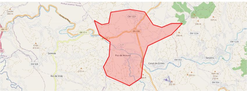
Figure 3 shows an example of the history of a property presented in the database.
In Figure 3 the original property was FozDeArouce (id = 1). Later, this property experienced
a division giving rise of two properties: Imovel1 and Imovel2. One of these properties, Imovel2,
after some time also suffered a division resulting in two other properties: Imovel3 and Imovel4.
Imovel4 go through a division resulting on two other properties: Imovel5 and Imovel6. After,
Imovel5 and Imovel6 were merged to form Imovel7, which is also merged with Imovel3 to form
Imovel8. Then, Imovel8 is merged with Imovel2 giving rise to Imovel9, that after is divided originating
Imovel10 and Imovel11. Finally, Imovel10 suffered another division that gives origin to Imovel12
and Imovel13.
Through the processes of division and union, there exist always an edition of the properties
created from the mentioned actions. The reason is because the properties that are created always copy
the data of the origin property. Other information must be entered, which distinguishes between the
parent property from the child property. This copy is mandatory because the QGIS functionalities
used for division and union do not allow to reverse these operations.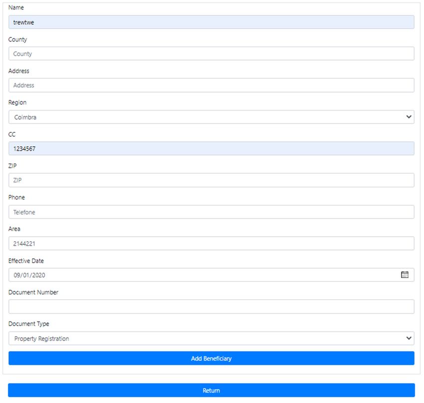
4. Experimental Results
       This section shows some of the functionalities of the Web application, including examples of
  land history.

  4.1. Analysis
  Information 2020,of11,
                      the  History
                         0554        of Properties                                                10 of 17

        Figure 3 shows an example of the history of a property presented in the database.

Information 2020, 11, x FOR PEER REVIEW                                                              10 of 17

     In Figure 3 the original property was FozDeArouce (id = 1). Later, this property experienced a
division giving rise of two properties: Imovel1 and Imovel2. One of these properties, Imovel2, after
some time also suffered a division resulting in two other properties: Imovel3 and Imovel4. Imovel4
go through a division resulting on two other properties: Imovel5 and Imovel6. After, Imovel5 and
Imovel6 were merged to form Imovel7, which is also merged with Imovel3 to form Imovel8. Then,
Imovel8 is merged with Imovel2 giving rise to Imovel9, that after is divided originating Imovel10
and Imovel11. Finally, Imovel10 suffered another division that gives origin to Imovel12 and
Imovel13.
     Through the processes of division and union, there exist always an edition of the properties
created from the mentioned actions. The reason is because the properties that are created always copy
the data of the origin property. Other information must be entered, which distinguishes between the
parent property from the child property. This copy is mandatory because the QGIS functionalities
used for division and union do not allow to reverse these operations.

4.2. Analysis of the Web Application
                                  Figure 3. Property history example in QGIS.
                                          Figure 3. Property history example in QGIS.
  4.2.InAnalysis
         this section,  we present
                 of the Web          some examples of the operations that can be done through the Web
                            Application
application.
      In this section, we present some examples of the operations that can be done through the
  Web application.
4.2.1. Property
  4.2.1. Property
    In Figure 4 it is possible to see what is presented in the Web application when selecting a
property.
      In Figure 4 it is possible to see what is presented in the Web application when selecting a property.

                                            Figure
                                             Figure4.
                                                   4. Visualization of aa property.
                                                      Visualization of    property.

     As we can see in Figure 4, the Web application presents a table with the parameters related to
property different buttons and a map with the visualization of the property. The buttons have the
following functionalities: Complete Registration that allows us to complete the registration of the
property; Property History to see the property history in more detail; Delete button that removes the
property; Complete Visualization allows us to see all the information related with the property. The
Beneficiary, Impacted, Destination, Litigation, Documents, and Thirty CM buttons redirect the user
Information 2020, 11, 0554 11 of 17
As we can see in Figure 4, the Web application presents a table with the parameters related to
property different buttons and a map with the visualization of the property. The buttons have the
following functionalities: Complete Registration that allows us to complete the registration of the
property; Property History to see the property history in more detail; Delete button that removes
the property; Complete Visualization allows us to see all the information related with the property.
The Beneficiary,
Information Impacted,
2020, 11, x FOR Destination, Litigation, Documents, and Thirty CM buttons redirect11
PEER REVIEW the
of 17
user to the respective pages where it is possible to view a table of each one.
4.2.2. Property History
4.2.2. Property History
Figure 5 below shows the history of a particular property.
Figure 5 below shows the history of a particular property.
Visualization of the history
Figure5.5.Visualization
Figure historyof
ofaaproperty.
property.
Figure 5 presents four tables: Target, Origin, Parent, and Child. Target shows the selected
property, Origin the original property, Parent the property from which derived (parent property)
and Child shows what properties it has originated (child property (s)). A map with the selected
property is also presented and when we click on the view button it is possible to view the respective
property on the same map. In this example, the property in purple is the property called Imovel1.
The properties of the same family will have the same Code. If we select a property, in this caseInformation 2020, 11, 0554 12 of 17
Figure 5 presents four tables: Target, Origin, Parent, and Child. Target shows the selected property,
Origin the original property, Parent the property from which derived (parent property) and Child
shows what properties it has originated (child property (s)). A map with the selected property is also
presented and when we click on the view button it is possible to view the respective property on the
same map. In this example, the property in purple is the property called Imovel1. The properties of the
same family will have the same Code. If we select a property, in this case “FozDeArouce”, we will look
at the Origin to see whether the name of the parent is written on it. In this case it did not have a name,
so this means this property is the original one. In order to see if this property has originated some
children, we look at the properties with the same Code and see if the Origin name in those properties
isInformation
the same2020,
of “FozDeArouce” and, if it is, then we have its children.
11, x FOR PEER REVIEW 12 of 17
4.2.3. Beneficiary
4.2.3. Beneficiary
In Figure 6, it is possible to see the process of creating a beneficiary, as well as viewing the
In Figure 6, it is possible to see the process of creating a beneficiary, as well as viewing the
respective table of beneficiaries of a given property. Here, we see how the property history is preserved
respective table of beneficiaries of a given property. Here, we see how the property history is
in the Web application.
preserved in the Web application.
Figure 6. Property “Serpins” (ID = 497).
Figure 6. Property “Serpins” (ID = 497).
The preservation of the property history remains in the Web application. In this example,
The preservation
we selected the property of“Serpins”,
the propertywithhistory remainstoincreate
the objective the Web application.
a new beneficiaryInfor
thisthis
example, we
property,
so we select the Beneficiary button in Figure 6. This action redirects the user to a new page where weso
selected the property “Serpins”, with the objective to create a new beneficiary for this property,
wesee
can select
thatthe Beneficiary
property buttonalready
“Serpins” in Figure 6. This
as one action redirects
beneficiary as shown theinuser to a7.new
Figure For page
addingwhere we
a new
can see that property “Serpins” already as one beneficiary as shown in Figure
beneficiary, we must fill a form as shown in Figure 8 and click in the “Add Beneficiary” button. 7. For adding a new
beneficiary,
We need we must fill
to create the ahistory
form asforshown
every in Figure
action that8 is
and click
done to in the
this “Add Beneficiary”
property button.each
(ID = 497), having
version of this property stored in the database. When we edit a property, the history must be preserved,
so we can have a “picture” of the property at any time. All the actions done in the Web application will
continue the pursuit of creating a history for all properties stored in the database.
Therefore, after we create the new Beneficiary, it is not added to the table Beneficiary of the
property “Serpins” with the ID = 497. To create a history, we duplicate the property (ID = 497) with
all the information this property and add the new beneficiary to the duplicate. Figure 9 shows the
duplicate created with the same name “Serpins” but with a new ID = 498. In Figure 10, we can see
that the duplicate has a new Beneficiary. When we duplicate the property to create a new one with
newly added information, everything that the property has, like beneficiaries, destinations and other
Figure 7. Beneficiary of the property “Serpins” (ID = 497).
are copied to the duplicate and the new information is added. Thus, in this example, the property
with the ID = 497 has one beneficiary, and when we created a new beneficiary, the Web application
We need to create the history for every action that is done to this property (ID = 497), having
created a duplicate of the property 497 and add the new beneficiary in the duplicate. In the database,
each version of this property stored in the database. When we edit a property, the history must be
we have the version of the property (ID = 497) with one beneficiary and the other version (ID = 498)
preserved, so we can have a “picture” of the property at any time. All the actions done in the Web
with two beneficiaries.
application will continue the pursuit of creating a history for all properties stored in the database.The preservation of the property history remains in the Web application. In this example, we
selected the property “Serpins”, with the objective to create a new beneficiary for this property, so
we select the Beneficiary button in Figure 6. This action redirects the user to a new page where we
Information 11, 0554 “Serpins” already as one beneficiary as shown in Figure 7. For adding 13
2020,property
can see that of 17
a new
Information 2020, 11, x FOR PEER REVIEW 13 of 17
beneficiary, we must fill a form as shown in Figure 8 and click in the “Add Beneficiary” button.
Information 2020, 11, x FOR PEER REVIEW 13 of 17
Figure7.7. Beneficiary
Figure Beneficiaryof
ofthe
theproperty
property“Serpins” (ID== 497).
“Serpins”(ID 497).
We need to create the history for every action that is done to this property (ID = 497), having
each version of this property stored in the database. When we edit a property, the history must be
preserved, so we can have a “picture” of the property at any time. All the actions done in the Web
application will continue the pursuit of creating a history for all properties stored in the database.
Figure 8. Beneficiary form for adding new beneficiaries.
Therefore, after we create the new Beneficiary, it is not added to the table Beneficiary of the
property “Serpins” with the ID = 497. To create a history, we duplicate the property (ID = 497) with
all the information this property and add the new beneficiary to the duplicate. Figure 9 shows the
duplicate created with the same name “Serpins” but with a new ID = 498. In Figure 10, we can see
that the duplicate has a new Beneficiary. When we duplicate the property to create a new one with
newly added information, everything that the property has, like beneficiaries, destinations and other
are copied to the duplicate and the new information is added. Thus, in this example, the property
with the ID = 497 has one beneficiary, and when we created a new beneficiary, the Web application
created a duplicate of the property 497 and add the new beneficiary in the duplicate. In the database,
Figure 8. Beneficiary form for adding new beneficiaries.
we have the version of Figure
the property (ID = 497)
8. Beneficiary formwith one beneficiary
for adding and the other version (ID = 498)
new beneficiaries.
with two beneficiaries.
Therefore, after we create the new Beneficiary, it is not added to the table Beneficiary of the
property “Serpins” with the ID = 497. To create a history, we duplicate the property (ID = 497) with
all the information this property and add the new beneficiary to the duplicate. Figure 9 shows the
duplicate created with the same name “Serpins” but with a new ID = 498. In Figure 10, we can see
that the duplicate has a new Beneficiary. When we duplicate the property to create a new one with
newly added information, everything that the property has, like beneficiaries, destinations and other
are copied to the duplicate and the new information is added. Thus, in this example, the property
with the ID = 497 has one beneficiary, and when we created a new beneficiary, the Web application
created a duplicate of the property 497 andProperty
add the
Figure9.9.Property
Figure new beneficiary
“Serpins” (ID==498).
“Serpins”(ID 498).
in the duplicate. In the database,
we have the version of the property (ID = 497) with one beneficiary and the other version (ID = 498)
with two beneficiaries.Information 2020, 11, 0554 14 of 17
Information 2020, 11, x FOR PEER REVIEW 14 of 17
Figure 10. Beneficiaries of the property “Serpins” (ID = 498).
Figure 10. Beneficiaries of the property “Serpins” (ID = 498).
5. Discussion
5. Discussion
When the properties are created in QGIS, they are automatically saved in the database that is
linked When
to thethe Web properties
application, are created
which allowsin QGIS, they
us to are automatically
include more information saved inin thethe database that is
properties.
linked Theto examples
the Web application,
of the Webwhich allows show
application us to include
some ofmore information
the aspects that in the theWeb
properties.
part contains,
where Thesiteexamples
pages’ followof the theWebsame application show some
basic principles. A of the is
table aspects
visiblethat evertheit Web part contains,
is possible to presentwhere
the
site pages’
content to the follow
userthe(Landsame basic principles.
Registry Specialist).AIftable is visible
the user needsever
to addit isnew
possible
content,to present
he or she themust
content
fill
to athe
in userand
form, (Landit isRegistry
also possibleSpecialist).
to delete If the user needs
a property to addAll
content. new data content,
filled inhethe or she must fill
respective in a
forms
form, be
must and it isin
filled also
by possible
Land Registryto delete a property
Specialist content.
to assure the All data filled
veracity of thein the respective forms must
database.
be filled
Thein Webby Land Registry
application Specialist
allows actionsto assure
such astheassociating
veracity of the database. complaints, intrusions,
inspections,
among The Web to
others, application
be associated allows
withactions such asproperties,
the respective associatingwhether inspections, complaints,
these are recent or intrusions,
properties
among
that have others,
already to be associated
existed, withnothe
but that respective
longer properties,
exist today. whether
Although theythese
do notareexist,
recent orpossible
it is properties to
that haveinformation
associate already existed, to thembut that mayno longer
help in exist
legaltoday. Although
processes or just they do not studies.
in market exist, it is possible to
associate information
The proposal to them
to the that may
property history helpalso
in legal
deeply processes
depends or on
justthe in market studies.
user’s performance. In the
exampleThe discussed
proposal to in the property
Section history
3.2, union andalso deeplyactions
division depends on the
require theuser’s
user to performance.
fill in many In of the
example
fields discussed
of the new createdin Section 3.2, union
properties. In aand division
division, theactions
user mustrequire enter thethe
usersame to fill
datain found
many inof the
fields of the
originated new created
properties, andproperties.
indicate theInorigin a division,
propertythethatusersuffered
must enter the same
division. This data
proposalfound in the
requires
originated
the user to properties,
do all theseand steps indicate
correctlythetoorigin property
maintain a historythat that
suffered division.toThis
corresponds proposal requires
reality.
the user
When to do all is
there these steps correctly
an addition, to maintain
the process a history
is similar that corresponds
to a division, and all thetohistory reality.is preserved if
When
the user willthereenteristhean correct
addition, theThese
data. process is similar
actions must to beaaccomplished
division, andwith all the
thehistory is preservedof
user responsibility if
user will
the user, enter the
retaining the desired
correct data.
qualityThese
of the actions mustbut
database, be needs
accomplished
a minimum withknowledge
the user responsibility
in the topic.
of the Inuser,
orderretaining
to preserve thethedesired quality
property history of the database,
solution in QGIS,but the
needs Weba application
minimum knowledgemust also createin the a
topic. for all these actions. Every information that is included in a property, will create an automatic
history
copyIn of order
the old toproperty,
preserve and the property
this new history
informationsolution in QGIS,
is added thecopy
to the Webproperty.
application must also create
a history
Thesefor all thesemodifications
properties actions. Every caninformation
be done in the thatWebis included
application in and
a property,
in QGIS.will Thus, create
we canan
automatic
edit copy ofin
all properties thetheold property,
database, and andthethis new information
modifications are addedis added
to thetoproperty
the copyhistory.
property. All actions
createThese
a historyproperties
versionmodifications
of a propertycan in the be database.
done in the Web application and in QGIS. Thus, we can
edit all
The properties in the database,
three components and the
(Database, QGIS,modifications are added to
and Web application) arethe property history.
interconnected All actions
materializing a
create a history
support tool for version of a property
land management. Within the
QGIS,database.
we create and edit properties, following the right steps
The three
to maintain thecomponents
history of these (Database,
properties, QGIS,whichandare
Web application)saved
automatically are interconnected
in the database. materializing
After using
a support
QGIS, we can toolcomplete
for land the management.
informationWith QGIS, with
associated we create and editby
the properties properties,
going to the following the right
Web application
steps to maintain the history of these properties, which are automatically
and adding information to the properties, which supports the history. Everything the user does within saved in the database. After
using
the siteQGIS, we can
will create complete
a history, and the information
the user will know associated
the evolutionwithofthe theproperties
property over by going
time. to the three
These Web
application andcomponents
interconnected adding informationcomprise to the for
a tool properties,
better land which supports the history. Everything the
management.
user does within the site will create a history, and the user will know the evolution of the property
6. Conclusions
over time. Theseand three Future Work
interconnected components comprise a tool for better land management.
In this work, we propose an approach that solves the property history problem keeping the
6. Conclusions and Future Work
historical data in the database. The proposed tool consists of three components: (i) the Web application,
(ii) the
Indatabase,
this work,and
we(iii) QGIS. These
propose three modules
an approach form the
that solves the solution
propertytohistory
the property history
problem problem.
keeping the
The database
historical stores
data all the
in the information
database. created in the
The proposed tooltool and QGIS
consists allows
of three the editing of
components: (i)properties,
the Web
application, (ii) the database, and (iii) QGIS. These three modules form the solution to the property
history problem. The database stores all the information created in the tool and QGIS allows theYou can also read