Urban Transport Institutions and and Integrated Land Use and Transport
←
→
Page content transcription
If your browser does not render page correctly, please read the page content below
Urban Transport Institutions and
                 Governance
   and Integrated Land Use and Transport,
                  Singapore

                      Paul Barter and Edward Dotson

                                 Case study prepared for

                     Global Report on Human Settlements 2013

                      Available from http://www.unhabitat.org/grhs/2013

Paul Barter is an Assistant Professor in the Lee Kuan Yew School of Public Policy, National
University of Singapore where he teaches infrastructure, urban and transport policy. His current
research interests are innovation in transport demand management policy, parking policy, public
transport regulation. Contact: paulbarter@nus.edu.sg.
Edward Dotson is a transport and urban planner who spent fifteen years working on urban transport
projects in Asia for the World Bank. He is the author of papers on sustainable transport and public
transport reform in China and on institutional support for urban transport in the developing world.
Contact: edwardbdotson@gmail.com.
Disclaimer: This case study is published as submitted by the consultant, and it has not been edited by the United Nations. The designations employed and the presentation of the material in this publication do not imply the expression of any opinion whatsoever on the part of the Secretariat of the United Nations concerning the legal status of any country, territory, city or area, or of its authorities, or concerning delimitation of its frontiers or boundaries, or regarding its economic system or degree of development. The analysis, conclusions and recommendations of the report do not necessarily reflect the views of the United Nations Human Settlements Programme, the Governing Council of the United Nations Human Settlements Programme or its Member States. Nairobi, 2011
Urban Transport Institutions and Governance
                and Integrated Land Use and Transport, Singapore
                                     Paul A. Barter and Edward Dotson

Introduction
Singapore is a City State. It was chosen for this case study because from the early 1970s it has
been regarded internationally as an exemplar of ‘good practice’ in integrated land use and
transport planning. It was the first city in the non-communist world to put into practice the
concept of restricting the ownership and use of motor vehicles, and of charging for the use of
road space. 1 These restrictions were an integral part of a land use and transport strategy
designed to be space-efficient, with high-density development, low land take for roads, and a
large role for space-saving public transport.
Singapore was also chosen as it has not always been the thriving economic hub that it is
today. At the time of the birth of the nation in 1965, Singapore had a GDP per capita of
US$516; a large percentage of the population lived in slums and a poor quality transport
system was in place. However, by 2010 the GDP had risen to US$63,867 per capita. 2
Singapore is also often regarded as a ‘special case’ because of its small geographical size and
population, and single level governance structure. Many regard these as the key or even
dominant influences in the successful integration of land use and transport in Singapore,
rendering them inappropriate to be held up for emulation. Singapore’s transport and land-use
policies have also sometimes been hailed a little too uncritically. This case study tries to
distinguish which elements of Singapore’s model can and should be considered for emulation
by others.
Singapore is now seeking to share and disseminate more widely its expertise. The Housing
Development Board (HDB) has established consultants Surbana, while the Ministry of
National Development has set up the Centre for Liveable Cities and the Land Transport
Authority (LTA) has set up the LTA Academy to provide training and/or share expertise in
the Singapore approach. Singapore is also offering a combination of expertise and investment
to support innovative new town development. A prime example is the Sino-Singapore Tianjin
Eco-City in China.
The case study starts with a brief overview of Singapore, including the governance structure,
population and economic growth. This is followed by a brief history of the spatial land use
and transport plans and policies.
The key issues identified in the case study are then presented, starting with the visions and the
planning, policy and management instruments underlying these plans, and the role of urban
sector governance. The successive land use and transport plans prepared in the period
between 1971 and 2008 are then discussed in more detail. The transport modes relied on in
the plans, and the extent of integration achieved on the ground are then analysed. The section
concludes with suggested criteria for evaluating the extent and effectiveness of integration,
and some performance indicators for Singapore.
The conclusions from the case study illustrate the strengths and weaknesses of the Singapore
model, the current threats and whether Singapore’s policies and practices are readily
applicable elsewhere.

1.    Prior to this cities had attempted restrictions on use through on and off street parking controls.
2.    Per capita GDP at current market prices, Department of Statistics, Singapore.

Urban Transport Institutions and Governance and                                              Case study prepared for the
Integrated Land Use and Transport, Singapore         Page 3 of 16             Global Report on Human Settlements 2013
Background Singapore is located on the southern tip of the Malay Peninsula, and is made up of a number of islands, with a total land area of 648 km2 which had increased through reclamation to 712 km2 by 2010 (Department of Statistics Singapore, undated). Singapore Island itself is 46 kilometres east to west and 23 kilometres north to south. Singapore has been a republic with a single level parliamentary system of government (on the Westminster model) since it gained sovereignty in 1965. The population of Singapore increased from 2.07 million in 1970 to 3.01 million in 1990 and to 5.077 million in 2010 (Department of Statistics Singapore, undated). The number of residential dwelling units increased from 180,600 to 735,900 over the same period, while the urban area increased from 32 to 52 per cent of the area of Singapore Island. Meanwhile, urban densities fell from 11,000 persons per square kilometre in 1970 to 8,350 in 2000. 3 Home (largely apartment) ownership has increased from about 25 per cent to 87.2 per cent in 2010, (Department of Statistics Singapore, undated) reflecting housing policy and the city’s rapidly growing affluence. The basic concepts underlying the urban development and transport plans and policies for Singapore have remained constant since the 1970s, even though updates have occurred at different times. A non statutory Concept Plan – incorporating spatial and transport planning elements – provides the development framework for Singapore within which more detailed Development Guide Plans (DGPs), consistent with the Concept Plan are prepared and implemented on an on-going basis. Adjustments, refinements and changes in emphasis in application of policies and plans have been made over time. Box 1. Urban sector governance The Housing and Development Board (HDB) established in 1960 is Singapore’s public housing authority and a statutory board under the Ministry of National Development. It is the sole agency responsible for the planning, design, land assembly and construction of public housing. A high proportion of Singapore’s home owners, own apartments in estates built and managed by HDB. The Urban Redevelopment Authority (URA) has been Singapore's national land use planning authority since 1989. Prior to that date this responsibility rested with the Planning Department in the Ministry of National Development. URA was established in April 1974, from the former Urban Redevelopment Department of the HDB (which had existed since 1967). Initially it was only responsible for planning the city centre. URA prepares long term strategic plans, known as Concept Plans, as well as detailed local area plans, known as Development Guide Plans (DGPs) for physical development (and conservation). It then co-ordinates and guides efforts to bring these plans to fruition. It is also a statutory board. The Land Transport Authority (LTA) established in 1995 is responsible for planning, policy and regulation of all urban (or land) transport modes, and their inclusion in the development of the Concept Plans. This made Singapore one of the pioneers of integrating so many urban transport responsibilities within one organization. The LTA also constructs and maintains road, MRT and other public transport infrastructure, in accordance with the provisions of the Concept Plans. It is also a statutory board. Jurong Town Corporation (JTC) is a statutory board responsible for the planning and development of industrial areas. Initially its focus was the development of the Jurong area in the west, the location of a great deal of industrial development. 3. 2000 population of 4.028 million and an urban land area of 479 square kilometres. Urban Transport Institutions and Governance and Case study prepared for the Integrated Land Use and Transport, Singapore Page 4 of 16 Global Report on Human Settlements 2013
The land use plans for Singapore have their origins in the State and City Planning Project
(SCP) launched in 1967, which resulted in the first strategic development plan, the 1971
Concept Plan. Known as the ‘Ring Plan’, as development was planned in a ring around the
central water catchment area, this was designed to guide the physical development of
Singapore over the following twenty years (to 1991). It was based on a compact urban
structure, with high density corridors containing housing, industrial areas and strong centres,
in a ring around the central water catchment area, with a strong city centre/central business
district (CBD). Public transport was to be steadily improved to meet urban movement needs,
with restraint of motor vehicle ownership and usage. Whilst the plan anticipated the later
introduction of a metro/MRT, the public transport system at this time was based on buses and
a firm decision to build MRT had not yet been made. The Concept Plan did not provide
detailed land use zoning and densities, nor was it a statutory plan – these two attributes were
still vested in the Master Plan. The use of Concept Plans in Singapore represents a successful
example of strategic planning.
Three initial important transport policy measures were implemented in the early 1970s. The
first was a package of measures to improve bus services, including by government direction,
the consolidation of eleven bus companies into three, and then just one. The second was the
series of steps taken to slow the growth of car ownership by increasing taxes on the purchase
and ownership of vehicles. The third was the introduction, in 1975, of the Area Licensing
Scheme (ALS), for traffic within the city centre (Barter, 2008).
The next major transport development was the construction (starting in 1983) of the East-
West and North-South MRT lines after a vigorous debate among policy-makers on whether it
was justified over an upgraded bus system. A key argument in favour of the expanded MRT
option was that without it and without the strong CBD it would support, higher order business
and finance sector investments would not be attracted to Singapore (Phang, 2003). The initial
sections were opened in late 1987.
A revised Concept Plan was produced in 1991 entitled: ‘Singapore – Towards a Tropical City
of Excellence’. This retained and refined the basic features of the earlier plan. The key
difference was a proposed strengthening of four regional centres to reduce congestion in the
city centre.
A further review and updating of the Concept Plan followed in 2001, and the broad strategies
incorporated into the 2003 master plan. The aim of the 2001 plan was to make Singapore into
a ‘thriving world class city’, with a 50 year horizon for a city of 5.5 million. This plan
included a Key Proposal for a more extensive rail network and a stronger reaffirmation of the
strong CBD strategy, slightly downplaying the role of regional centres compared with the
1991 plan. A review of the 2001 Concept Plan is scheduled for completion in 2011.
Following the setting up of the Land Transport Authority (LTA) in September 1995, a
transport White Paper (Policy Document) was published in January 1996, entitled ‘A World
Class Transport System’ (Republic of Singapore, 1996). In October 2006 LTA, in
consultation with the Ministry of Transport, began a Land Transport Review, which
culminated in the Land Transport Master plan entitled ‘A People Centred Land Transport
System in February 2008’.

Main Issues
The integration of land use and transport in Singapore is greatly fostered by the government
having a clear vision for the future of Singapore, and well-articulated policies, planning and
management instruments including a well-defined governance structure of institutions

Urban Transport Institutions and Governance and                                 Case study prepared for the
Integrated Land Use and Transport, Singapore      Page 5 of 16   Global Report on Human Settlements 2013
responsible for key activities. It is also facilitated by these institutions working together to
prepare and implement land use plans and transport strategies. While overall the strategic
spatial planning and transport policy directives for Singapore are integrated, this has been
largely achieved without the administrative and legal integration of institutions and
governance of land use and transport. Instead, inter-agency committees ensure the integration
of planning and implementation. This is contrary to a view that is often advocated that
integrated plans can only flow from integrated institutions.
This section sets out the vision, and describes the policy, planning and management
instruments, including the governance structure. The evolution of the vision, key polices to
support the vision and key instruments through the land use and transport plans listed in urban
sector governance section from 1971 to the present day is then laid out. Then follows an
assessment of the results, for example in the importance of public transport and the extent of
integration being achieved on the ground. The section concludes with a discussion of the
evaluation criteria that should ultimately be employed to judge the success of the integrated
plans.
Underlying visions
Starting with the 1971 Concept Plan, the integrated land use/transport plans are all driven by a
clear vision for the socio economic and urban development of Singapore. In the 1971, Plan
this vision included:
An urban structure based on mass transit spines, radiating out from a strong CBD,
with the centres of ‘new towns’ located at stops along the spines;
A land use plan for each new town based on a grouping of neighbourhoods which
were relatively self sufficient in terms of local commercial, educational, health,
social and recreational facilities;
Decentralization of population from poor quality and overcrowded (‘slum’)
housing in the city centre to new multi-storey housing in the new towns;
Promotion of movement by public transport, with restraint on car ownership and
use;
Limited road construction due to constraints on land availability; and
Creation of heavy industrial areas separate from the new towns.
The vision of spatial development in this plan, and the role of public transport within it, is
influenced by European urban planning thought of the 1950s and 1960s – but the restraints on
car ownership and usage were newer and their application together has not been adopted
before outside Singapore. The 1971 vision sought to separate heavy industrial and residential
areas, and assumed that many people would travel outside the new towns to work in the CBD
or the industrial areas – by the high quality public transport system that was to be provided.
Early new town planning sought to mitigate this by including light industrial development
within new towns.
By 1991, the vision had expanded to create a ‘Tropical City of Excellence’ for 4 million
people by 2030. While the basic vision of urban development from the 1971 Plan was
retained in the 1991 Plan, this plan also incorporated some refinements. One key refinement
in the new vision was to seek to decentralize more of the growth in economic activities to four
regional centres. At the same time the vision of a strong CBD was retained by a proposed
extension of the CBD to Marina South.
In the 2001 Concept Plan (Republic of Singapore, 2001), the visions in the previous plans
were again refined. The emphasis is for Singapore to become ‘a city that is dynamic,
Urban Transport Institutions and Governance and Case study prepared for the
Integrated Land Use and Transport, Singapore Page 6 of 16 Global Report on Human Settlements 2013distinctive and delightful, as well as enhancing the quality of life’. The key new vision is to
establish a global business centre, and allow greater flexibility to business, which are required
to ensure sustainability of employment in a globally competitive business environment. The
expansion of the CBD was re-emphasized more strongly than ever. The regional centres (one
fewer in number) were retained but with lower expectations for their importance, reflecting a
slower than anticipated market response to their development.
Policy, planning and management instruments
Achievement of the visions for Singapore is facilitated by a set of planning, and policy
instruments applied within the urban sector governance structure outlined in the background
section by agencies with clear roles and responsibilities. The key instruments are:
Concept plans prepared by the URA as the agency responsible for spatial planning;
Development guide plans (DGPs) also prepared by the URA which together form
what is known as the Master Plan;
Transport policies and plans prepared by LTA; and
Detailed plans for the development of new towns prepared by HDB, and for
industrial areas, prepared by JTC.
The mechanism for the preparation of the Concept Plan is notable as a good example of a
strategic planning approach, adopted to overcome the problems associated with the
preparation of ‘master plans’- in particular the time needed to prepare them, the long drawn
out process, the amount of detail of such plans and their lack of connection with key levers of
influence over urban development, such as infrastructure investments. The Concept Plan lays
out the vision for development over at least a 20 year horizon, and the key actions to achieve
the vision. It shows the main land uses (residential, commercial, and industrial) and the MRT
and main road networks. The Concept Plans in Singapore are now reviewed and updated
every 10 years.
The Concept Plan is not a statutory plan but provides the framework for the preparation (also
by the URA) of the statutory land use plans – known as Development Guide Plans (DGPs),
which together form what is known as the Master Plan. There are DGP for 55 areas, which
together form the 2008 Master Plan. These DGPs contain details of land use zoning, plot
ratios, building heights as well as conservation areas and other controls on development. They
are accompanied by a ‘Written Statement’ which explains the various items included in the
DGP. This approach has its origins in the Development Plans of the mid 20th century British
planning system. The DGPs are used to control what development is implemented by private
developers or government agencies.
Transport: The Concept Plans incorporate transport policies and the major transport
infrastructure networks and facilities, and provide the framework for the formulation and
implementation of more detailed transport strategies, policies and programs by the LTA in
support of the Concept Plans. Transport elements were an integral part of the 1971 Concept
Plan – with policies on restricting car ownership and use and promoting public transport,
limited road infrastructure and spatial development based on public transport spines. While
this approach was retained in later Concept Plans, more specific transport policies and plans
were also developed separately from them. The Concept Plans and the DGPs together
influence all development and provide the framework for the preparation of detailed plans for
the development of new towns by the HDB. Construction of the transport infrastructure and
new towns is then undertaken by these same agencies.
Urban Transport Institutions and Governance and Case study prepared for the
Integrated Land Use and Transport, Singapore Page 7 of 16 Global Report on Human Settlements 2013This division of planning and policy making into three levels – i.e., strategic, detailed/tactical and operational/implementation – is highly effective as it separates out the three stages of the process for the creation of urban environments, which require different skills and mind-sets. The Concept Plans covers aspirations, what the community wants to achieve, and confronts major strategic trade-offs and dilemmas – quite deliberately without getting bogged down in details. The DGP and the Transport Plans (TPs) take the concepts as a starting point and provide the details of how the aspirations are to be achieved. The operational plans then bring the concepts to fruition. The periodic review and updating process in all the levels provides feedback loops that allow adjustments to be made in response to changing aspirations and circumstances. Role of urban sector governance The effectiveness of the integration of land use and transport developments in Singapore is greatly assisted by having two key agencies for planning and policy, namely: the URA for spatial development and land use, and the LTA for all modes of transport. It is often argued that integration can only be achieved if the agencies responsible for land use and transport planning are themselves integrated into one overarching agency. In Singapore, the mechanism of cross- agency committees is used instead, which works effectively in part because the Singapore Government as a whole is relatively integrated, with less of the departmental silos culture frequently seen in other national and city governments. Another factor contributing towards integration is the large percentage of land in government ownership. The government uses land release strategically as a proactive means to guide the implementation of the Concept and Land Use Plans. The Land Acquisition Act was also important. This was crucial in allowing HDB and JTC to get access to land affordably and expeditiously. It was amended in 1966 to greatly broaden the legal basis for government acquisition of land. Land can be acquired for any use deemed to be in the public benefit. The Act allowed the land around most MRT stations to be acquired before construction, so that it was usually the government which reaped any windfall in land values from the MRT investments. Integration of land use and transport – strategic and statutory plans The 1971 SCP – Ring Plan The 1971 Concept Plan was the first in a series of Concept and Transport Plans produced for Singapore which set out the ways in which land use and transport are to be integrated. This plan decentralized population into HDB new towns away from the city centre, and connected them by an efficient transport system of roads, expressways and public transport, with corridors planned for MRT. This plan was structured around mass transit spines, with the centres of satellite ‘new towns’ being integrated with and located around mass transit stops. The centres contain local shopping and other commercial and community services commensurate with the population envisaged in the new towns (i.e. between 20,000 and 40,000 families; or 60,000 to 120,000 people). Up to seven residential neighbourhoods (each containing 4000–6000 families) are grouped around the centre. In addition to housing, these neighbourhoods contain schools, community and recreation facilities. A system of pedestrian routes link the neighbourhood Urban Transport Institutions and Governance and Case study prepared for the Integrated Land Use and Transport, Singapore Page 8 of 16 Global Report on Human Settlements 2013
centres to the town centre and the MRT stop (Cervero, 1998). A bus interchange in the centre
provides for longer distance trips from residential areas out of walking distance. 4
The plan also provided for some 24 industrial ‘estates’ spread around the island, with a major
concentration in the western part of the island where the port is also located.
While the plan aimed for self containment to some extent, in practice major employment
centres were originally missing from the new towns. As a result, up to 80 per cent of
employed residents travelled outside their new town to work to jobs in the CBD, the major
industrial areas – or to other new towns. Unfortunately this arrangement – not without its
critics (Willoughby, 2000) – reflected at the time a classic lack of integration between the
distribution of housing and employment opportunities which has been rectified in later plans.
It should be noted that a simple balancing of job opportunities with employed residents would
not eliminate out commuting, but would reduce the necessity for people to commute.
The policy objectives of the plan were for a public transport orientated compact urban
structure, with restraint on both motor car ownership and usage. The background studies to
the Plan made it clear that the limited land available in Singapore could not accommodate the
extent of the road network required to provide the anticipated travel demand if the travel was
undertaken primarily by private car. This realism about the constraints faced in land use and
transport planning is perhaps something other cities could emulate. The whole planning and
design approach was therefore directed towards facilitating the use of public transport, with
public transport investment becoming a clear policy objective. Notwithstanding this, it was
argued that a good quality free flowing arterial road network was also vital for the economic
efficiency and growth of the city. The concept of ‘free flowing’ traffic has perhaps been
overemphasized in the design and management of the network as it has resulted in travel by
car being quicker than travel by public transport.
The 1991 Revised Concept Plan
In the 1991 Plan, transport considerations resulted in two key refinements to land use
planning strategies for Singapore:
The decentralization of some growth in commercial and other economic activities
from the city centre (in addition to housing), through the development of regional,
sub-regional and fringe centres at MRT stations; and
The location of employment areas (such as industrial estates, business parks and
commercial centres) near to residential areas, with the intention of reducing the
need for vehicular travel to work. In particular, more homes were to be built in the
western part of the island, while more employment centres would be created in the
east.
Despite these refinements, many plots of land close to the stations on the original MRT
network opened in 1987 were only developed by 2010, and some cases still remain vacant.
This allows flexibility in the location of still to be identified land uses, but also leaves the new
towns with unfinished town centres.
4. This is a classical layout that physically integrates land use and transport facilities.
Urban Transport Institutions and Governance and Case study prepared for the
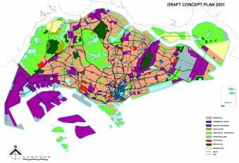
Integrated Land Use and Transport, Singapore Page 9 of 16 Global Report on Human Settlements 20132001 Concept Plan
This supersedes the 1991 Plan. The vision set out in the Concept Plan for 2001 is to develop
Singapore into a thriving ‘world-class city’ in the 21st century based on a population scenario
of 5.5 million. The key proposals of this plan are:
Providing more new homes in familiar places – which places an emphasis on
increasing the population in the central area and in older inner areas;
Introducing more high-rise city living;
Offering more choices for recreation;
Allowing greater flexibility for businesses;
Establishing a global business centre;
Building an extensive rail network; and
Focussing on identity.
This plan reaffirmed the importance of the CBD and placed less emphasis on the regional
centres and sub-regional centres. It is interesting to note that the publicly available version of
Plan includes only one reference to transport. While this proposal does not refer to
integration, the more extensive rail network consists of two orbital lines one of which links
five sub regional centres, the other which links the three regional centres.
Figure 1: Concept Plan 2001
Source: Lim and Tang 2001
Urban Transport Institutions and Governance and Case study prepared for the
Integrated Land Use and Transport, Singapore Page 10 of 16 Global Report on Human Settlements 2013The 1996 Transport White Paper ‘A World Class Transport System’
This document was produced following the creation of the Land Transport Authority (LTA)
in 1995. It sets out the vision of the Singapore Government to build a land transport system
that would meet the needs and demands of a dynamic and growing city. One of the four key
strategies to realise this vision was integrating land use and transport planning. The White
Paper states ‘The importance of an integrated land use and transport planning approach cannot
be overemphasized.’
The 1996 White Paper emphasizes the importance of planning at a ‘micro level’ to integrate
land use around MRT stations. It advocates concentrating the highest density (plot ratio)
developments around major public transport nodes such as MRT stations and dispersing less
compact developments further away from these modes. It then discusses the progressive
release by URA of land around MRT stations for development – not just commercial
development – but also high rise residential developments. It also talks of aiming for a proper
mix of residential, industrial and even institutional developments and the highest plot ratios at
and around MRT stations. This is seen as a way of providing good accessibility to key centres
providing employment, housing, leisure and other activities.
The 2008 Transport Master Plan – A People Centred Land Transport System
This continues the approach to land-use and transport integration in the 1996 White Paper, but
with some refinements, including:
Increased commitments to provision of more covered pedestrian linkways and
pedestrian (covered) bridges linked to developments and pedestrian networks in
developments in order to enhance the accessibility of public transport;
More PT interchanges ‘co-located’ with retail and commercial development; and
Continuation of the reduction in parking requirements per square metre in new
developments that had been started in the 1990s.
In addition new road infrastructure was to be built to serve new development areas, or to
increase the capacity to existing areas. There are also proposals to expand the Rapid Transit
System (RTS) network from 138 kilometres to 278 kilometres, and a new North-South
Expressway.
Walking and cycling were both included under the heading of ‘Supporting Measures’, but
without any strong commitment to their potential roles. This limited coverage of walking
related to recommendations to promoting walking through better pedestrianization and town
planning, and building cycle facilities at MRT and bus interchanges away from the city.
Transport modes relied on in the plans
As noted above, the plans in Singapore rely heavily on public transport as the means of
transport for people, and in particular place emphasis on rail transport, both metro (MRT) and
LRT. Even so, far more trips are made every day on buses than by rail. Until recently, not as
much attention was paid to improving this mode of public transport, in terms of service
coverage, operations and infrastructure, as was paid to MRT; a phenomenon that is not unique
to Singapore. The 2008 Land Transport Master Plan recognized this to an extent by
announcing that the LTA would take over bus route planning from the franchised bus
operators as part of a renewed push for even stronger integration of the public transport
network.
Urban Transport Institutions and Governance and Case study prepared for the
Integrated Land Use and Transport, Singapore Page 11 of 16 Global Report on Human Settlements 2013While steady improvement of the city’s public transport has been a major commitment, with significant investment in supportive high quality infrastructure, there has been less focus on public transport service delivery and on the quality of service to users. In the government’s recent transport strategy there is some recognition of this fact – reflected in the stated need to improve public transport by making it a ‘mode of choice’. The strategy also recognizes the need to improve the bus system more rapidly – with more extensive on-road priority measures, a shift to contestable bus route tranches at some point, and the LTA taking over the planning of bus routes. More surprisingly, little attention has been paid to cycling and walking as a means of transport – either stand alone, or as access modes to MRT and bus services. This is beginning to change but much remains to be done. Pedestrian routes are provided in new towns, but are rather spartan. Early MRT-bus interchange designs sometimes required overly long walks between platforms and bus boarding and alighting points. Recent rail – bus interchanges have been reducing these distances and improving the quality of connections greatly. There is a new program to improve conditions for cycling as an ‘intra-town’ mode. Given the restrictions on car ownership and use, roads are not planned as the main means of transport of people. However, a high quality free flowing road network is considered critical to support the economic activities and efficiency of the City State. Goods within Singapore are transported exclusively by road. While the lack of space, rather than lack of finance was the driver for limiting the provision of additional road space over the years, this has not prevented the construction of roads per se or a highly sophisticated road network. Although not intended as structuring elements in plans, by their overall width the arterial roads and expressways do act as such. The density and scale of the road network is however a function of the private car travel demand in the peak period, which in turn is a function of the price, put on car ownership and use, rather than a reflection of road freight transport needs. 5 This balance between the supply and demand of road infrastructure is not static and has been reassessed at the review of the Concept or Transport plans. This has even included consideration of a Singapore Underground Road System (SURS) to provide extra road space that would permit a significant increase car ownership and use. 6 The informal public transport sector has not made any contribution to meeting the transport demand in Singapore since the early 1970s, at a time when the formal public transport was not providing an adequate quantity or level of service. Given the circumstances, the government subsequently stepped in to reform the formal public transport and at the same time largely erase the informal sector. Extent of integration being achieved on the ground Overall, a high degree of land use/transport integration is being achieved on the ground in Singapore. At a city level, this is not surprising given the integrated spatial planning of land uses and transport networks, and implementation of new towns and rail infrastructure programmes in accordance with these plans. There are of course some exceptions – for 5. Although some projects along the west coast corridor – such as the new ‘semi-expressway’ road viaduct along Pasir Panjang Road/West Coast Highway – clearly reflect freight transport priorities. 6. There are two long-standing tunnel sections of the Central Expressway (CTE) and the new Kalland Paya Lebar Expressway (KPE) has 12 kilometres underground. Underground sections are planned for the North South Expressway. Urban Transport Institutions and Governance and Case study prepared for the Integrated Land Use and Transport, Singapore Page 12 of 16 Global Report on Human Settlements 2013
example the construction of the Bukit Panjang LRT was conceived after the new town was
developed and so it was difficult to integrate the line well with the land uses.
At an overall city level also, adjustments have been made over time in the distribution of
residential and commercial/industrial land uses in order to reduce journey to work travel
demands and produce more balanced two way flows on the network.
At a more local level, locations around MRT stations have been safeguarded for types of
development that would benefit from the enhanced accessibility and transport capacity
provided by the MRT. This approach allows flexibility in the location of still to be identified
land uses, but has also left many of the new towns with unfinished town centres for a
surprising length of time (since the late 1980s when the first MRT lines opened).
However, at a more detailed human scale, it could be argued that the integration of land use
with transport in Singapore is not entirely satisfactory. The arterial roads by their design, scale
and land-take are wide and not integrated with the surrounding areas, but instead act as
barriers to pedestrian movement. Most major road junctions have large radius slip lanes for
turning vehicles, which causes detours and hazards for pedestrians and cyclists. Given the
space constraints, a surprisingly generous amount of space is devoted to large intersections.
Design guidelines resist the building of anything like a traditional street. Instead residential
areas, consist of large superblocks of apartments in parkland with car parking (in a Modernist
style reminiscent of Le Corbusier). While HDB housing areas are highly permeable for
pedestrians and their internal traffic is low-speed, they lack ground-level interest.
The integration of local area planning and transport has not focused on creating a human scale
built environment, supporting local area movement networks, and providing user friendly
access to public transport to the extent that might be expected given the wider strategies. This
is reflected in the limited attention that appears to have been given to walking and cycling,
while most pedestrian facilities are adequate but basic. On a more positive note, a high
priority given to tree planning over several decades provides crucial shade and there is a large
program to provide covered walkways throughout the new towns. Most new town centres
have pedestrian oriented designs and pleasant car-free areas in their cores.
The Orchard Road shopping area perhaps illustrates the tension between traffic priority and
the pedestrian realm in Singapore’s approach. Pedestrians are provided with quality space but
it is segregated from vehicles so as not to interfere with the traffic flows. There are
exceptions, including the renovated riverside areas of Boat Quay, Clarke Quay and Robertson
Quay, with their mixed-use developments, re-use of old buildings, and quality pedestrian
space.

Role of size of Singapore and single level of government in Singapore
The small size of Singapore facilitates the integration of government policy formulation and
decision making and could be considered as one of the most significant explanatory variables
for successful integrated development. However, it can be argued that the relative absence of
departmental silos, and use of cross agency committees make a greater contribution – and one
that can be replicated elsewhere given the will of technical staff and leadership by
departmental heads.
Similar arguments can be applied to the unitary structure of the Singapore Government. This
removes the policy, planning and design mismatches and demarcation disputes than can arise
between two levels of government. But such mismatches can be minimized and managed if
the roles and responsibilities of the different levels of government are reasonably clearly

Urban Transport Institutions and Governance and                                  Case study prepared for the
Integrated Land Use and Transport, Singapore      Page 13 of 16   Global Report on Human Settlements 2013
defined – and if a political (or technical) process is put in place for dispute resolution. It is
accepted that creating such well structured and functional institutional arrangements may be
asking a lot in many developing cities – but are not beyond the bounds of what is possible and
achievable. But mismatches that affect integration are not likely to occur unless responsibility
for urban development rests with a different level of government to that for transport
infrastructure. (It is accepted that outside Singapore charging for use of road space may be
seen as affecting national taxation policy as well as local transport policy, and so take time to
introduce while the different levels of government sort out their differences.)
Critical evaluation and appraisal criteria
The criteria to assess the extent and effectiveness (i.e. success) of land use/transport
integration should include concern for:
Reducing at the city level the overall demand for motorized travel, through the
spatial distribution of population and job opportunities and the spatial distribution
of shops, education, health and community facilities.
Ensuring at the city level that the catchment area and/or trip generation of land
uses is matched by the catchment provided by their location on transport
infrastructure. For example, are land uses with a city wide catchment located at a
PT hub with city wide access?
Ensuring that higher density residential development have been located close to PT
routes and interchanges (Transit Orientated Development).
Ensuring that industrial/warehousing areas have been located close to major
interchanges on the road network?
Designing residential and other areas to create a pleasant urban environment by
removing traffic though the layout and design of the road networks?
Designing local areas with walking and cycling as the primary means of mobility
to access local facilities?
Refraining from requiring excessive amounts of vehicle parking space (Singapore
does have minimum parking requirements but they are now modest and relatively
realistic in light of the actual demand for parking which is almost always priced)
(ADB, 2011).
Provided the data (and modelling) is available, quantitative values can be put on a number of
these criteria. However for most cities, a qualitative assessment by urban planning
professionals may be all that is possible. In the case of Singapore, through trial and error (and
the post implementation monitoring of plans and taking corrective actions), it is considered
that five out of the above six criteria have been fulfilled – with the result that much of what
has been achieved could be judged a success. Only with regard to designing local areas could
Singapore be considered as ‘work in progress’.
Conclusion
Singapore was chosen for a Case Study as it has long been regarded as an exemplar of
integrated land use and transport planning (and also of the development of good urban
transport institutions and governance). The overall lesson is that while the small population
and geographic size contribute towards the successful integration of urban development and
transport in Singapore, the policies and practices are replicable elsewhere in larger cities, and
where two levels of government are present. However this does require adequate institutional
capacity and a good governance structure – two of the key strengths of the Singapore model.
Urban Transport Institutions and Governance and Case study prepared for the
Integrated Land Use and Transport, Singapore Page 14 of 16 Global Report on Human Settlements 2013The other strengths of the Singapore model are:
A set of visions, objectives and policies for land use/transport integration that have
remained consistent from 1971 up to and including the 2008 Master Plan.
Any plan or policy update or amendment has been based on a clear technical
review and analysis of experience, as well as changing circumstances.
Creation of the LTA which has played a key role in the integration of land use and
transport developments by providing a long term vision, clear policy objectives
and a comprehensive policy, financial and regulatory framework for transport.
Use of infrastructure investment as a means to facilitate the implementation of
Concept and Master Plans. This is not a new concept, but in Singapore it was
applied within the framework of an agreed Plan, and after due analysis of the
desirable timing of investment. MRT infrastructure was built as a catalyst to
corridor development, but only after a vigorous debate on the value of investing in
the first two lines. More recently, road investment was also used to support
development, particularly commercial and industrial development in specific areas.
A well planned and designed road network to facilitate/support the economic
functions of a city in addition to a well planned and designed public transport
system, and restrictions on vehicle usage. Road space provided was designed to be
adequate to provide a good level of service based on the vehicle population (and in
return for high costs of use). This lesson is perhaps one of the more surprising, but
logical lessons from Singapore’s transport policy.
These are all lessons that can be applied on other cities.
The weaknesses are:
A focus on strategic concepts and detailed master plans, with insufficient attention
to integration at the local or neighbourhood level, where a human scale is required
in designs.
Limited support for non-motorized movement (walking and cycling).
Integration was used to achieve a single strategic land use objective. The 1971
SCP sought to reduce density in the CBD, and to improve housing conditions
through the creation of new towns, and was very effective in doing so. However,
these were in effect ‘dormitory towns’. The later plans sought to make these towns
more self sufficient to reduce the need for commuting out – and balance the flows
on the network.
The difficulty of improving sufficiently the quantity, quality and level of service of
public transport to keep up with demand and rising aspirations, especially in the
bus system. The lesson here is that even with motor car restraint measures in place,
public transport must be continuously improved to be an attractive mode of choice
– especially in affluent societies/among high income groups.
While many aspects of LTA policy and practice would be recognized as
contributing to visions of sustainable transport, this has not been stated as a formal
objective of LTA policy until quite recently.
These are weaknesses that should be avoided in other cities.
The current threats to integration in Singapore are:
Continuing growth in car ownership and use, despite the restraint measures that are
in place. Proactive management (coupled with continuous investment) is needed to
make the most effective use of available road space. Growth in car ownership is a
Urban Transport Institutions and Governance and Case study prepared for the
Integrated Land Use and Transport, Singapore Page 15 of 16 Global Report on Human Settlements 2013threat globally. The threat in Singapore is if despite restraint, it starts to seriously
exceed supply of road space, leading to pressure for further road widening.
Slow implementation of the proposals to make LTA responsible for overall bus
network planning and introduction of greater competition in the supply of services.
References
ADB (Asian Development Bank) (2011) ‘Parking policy in Asian cities’, Asian Development Bank,
Manila
Barter, P.A. (2008) ‘Singapore’s urban transport: Sustainability by design or necessity? in T-C. Wong,
B. Yuen and C. Goldblum (eds) Spatial Planning for a Sustainable Singapore, Springer,
Dordrecht, pp. 95-114
Cervero, R. (1998) The Transit Metropolis – A Global Enquiry, Island Press, Washington, DC, p160
Department of Statistics Singapore (undated) ‘Statistics’ Department of Statistics Singapore,
http://www.singstat.gov.sg/stats/stats.html, last accessed 25 July 2011
Lim, R and S. Tang (2001) ‘Draft concept plan 2001 in Skyline May/June 2001’, Urban
Redevelopment Authority, Singapore.
Phang, S.Y. (2003) ‘Strategic development of airport and rail infrastructure: the case of Singapore’,
Transport Policy 10(1): 27–33
Rakodi, C. and Devas. N. (1993) Managing Fast Growing Cities – New Approaches to Urban
Planning in the Developing World, Longman, London
Republic of Singapore (1996) ‘A world class land transport system’, White Paper presented to
Parliament, Land Transport Authority, Singapore
Republic of Singapore (2001) ‘Concept plan 2001’, Urban Redevelopment Authority, Singapore
Republic of Singapore (2008) ‘LT master plan – A people centred land transport system’, Land
Authority, Singapore
Willoughby, C. (2000) ‘Singapore’s experience in managing motorization and its relevance to other
countries’, Discussion Paper TWU – 43, The World Bank, Washington, DC
Urban Transport Institutions and Governance and Case study prepared for the
Integrated Land Use and Transport, Singapore Page 16 of 16 Global Report on Human Settlements 2013You can also read