MTHEMBU TRADITIONAL SETTLEMENT MASTER PLAN - Prepared by: SYDWALT (PTY) LTD
←
→
Page content transcription
If your browser does not render page correctly, please read the page content below
MTHEMBU TRADITIONAL
                       SETTLEMENT MASTER PLAN

Prepared by: SYDWALT (PTY) LTD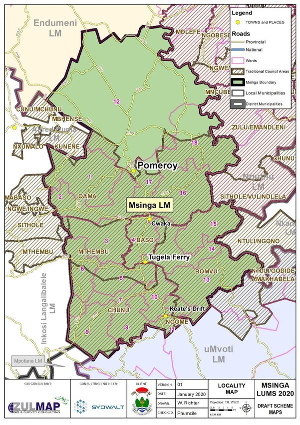
MSINGA LOCAL MUNICIPALITY: MTHEMBU TRADITIONAL SETTLEMENT MASTER PLAN

TABLE OF CONTENTS                                                                                                       7.2.3 EMPLOYMENT TRENDS ............................................................ 13
1.      INTRODUCTION .................................................................................. 3            7.3      LAND OWNERSHIP .................................................................... 13
2.      BACKGROUND .................................................................................... 3            7.4        ENVIRONMENTAL ANALYSIS .................................................... 13
3.      THE UNDERLYING PRINCIPLE FOR THE STUDY .................................. 4                                     7.4.1         TOPOGRAPHY .................................................................... 13
4.      THE STUDY AREA ................................................................................ 4               7.4.2         GEOLOGY ........................................................................... 14
5.      THE PROJCET APPROACH AND METHODOLOGY ............................... 7                                          7.4.3         ENVIRONMENTAL SENSITIVITY.......................................... 15
6. LEGISLATIVE AND POLICY PERFORMANCE MEASURES ......................... 8                                              7.4.4 RIVER CATCHMENT................................................................. 16
     6.1. THE NATIONAL CONTEXT ................................................................. 8                   7.5        HOUSING .................................................................................. 16
        6.1.1. THE NATIONAL DEVELOPMENT PLAN ....................................... 8                               7.6      SOCIAL FACILITIES ..................................................................... 16
        6.1.2. THE SPATIAL PLANNING AND LAND USE MANAGEMENT ACT,                                                        7.6.1 EDUCATIONAL .......................................................................... 16
        16 OF 2013 .......................................................................................... 8         7.6.2 COMMUNITY HALL ................................................................... 17
        6.1.3. MUNICIPAL SYSTEMS ACT, 32 OF 2000..................................... 9                                 7.6.3 PLACE OF WORSHIP.................................................................. 18
     6.2. THE PROVINCIAL CONTEXT ............................................................ 10                        7.6.4 HEALTH CARE ........................................................................... 18
        6.2.1. PROVINCIAL GROWTH AND DEVELOPMENT PLAN (PGDP) ..... 10                                                   7.6.5 LOCAL ECONOMIC DEVELOPMENT .......................................... 19
        6.2.2. THE INGONYAMA TRUST ACT, 3 OF 1994 ............................... 10                                    7.6.6 ROAD INFRASTRUCTURE .......................................................... 19
     6.3. THE LOCAL CONTEXT ...................................................................... 10                   7.6.7 LAND USE AND SETTLEMENT PATTERN ................................... 19
        6.3.1. UMSINGA IDP AND SPATIAL DEVELOPMENT FRAMEWORK. .. 10                                                  7.8      STATUS QUO SWOT ANALYSIS .................................................. 20
        6.3.2. UMSINGA HOUSING SECTOR PLAN ......................................... 11                           8. KEY DEVELOPMENT CHALLENGES ........................................................ 20
7. STATUS QUO ANALYSIS ........................................................................ 11                   8.1 OUTCOMES FROM THE PUBLIC CONSULTATION ............................ 20
     7.1       STUDY AREA .............................................................................. 11          8.2 PROPOSALS GOING FORWARD ....................................................... 21
     7.2 SOCIO ECONOMIC PROFILE ............................................................. 11                  9. SPATIAL CONCEPT & STRATEGY ........................................................... 21
        7.2.1 POPULATION GROWTH ............................................................ 11                      9.1 MTHEMBU TC VISION...................................................................... 21
        7.2.2 HOUSEHOLD INCOME .............................................................. 13                     9.2 APPROACH TO DEVELOPING GOALS, STRATEGY & PLAN................ 21

1|Page
MSINGA LOCAL MUNICIPALITY: MTHEMBU TRADITIONAL SETTLEMENT MASTER PLAN

   9.3 MTHEMBU DEVELOPMENT STRATEGIES......................................... 22                               Map 1: izigodi .............................................................................................. 5
       9.3.1 ENCOURAGE MIXED LAND USES .............................................. 22                        Map 2: Locality Map of Traditional Councils............................................... 6
                                                                                                                Map 3: Population Density ........................................................................ 12
       9.3.2 IMPROVE TRANSPORTATION CONNECTIVITY .......................... 22                                  Map 4: Topography ................................................................................... 14
       9.3.3 PRESERVATION OF AGRICULTURAL LAND ............................... 22                               Map 5: Geology ........................................................................................ 15
       9.3.4 PROTECTION OF ENVIRONMENTALLY SENSITIVE AREAS ......... 22                                         Map 6: Environmental Sensitivity ............................................................. 16
                                                                                                                Map 7: Educational Facilities .................................................................... 17
       9.4 PROPOSED LAND USES ................................................................ 22               Map 8: Social facilities ............................................................................... 17
10. IMPLEMENTATION FRAMEWORK ...................................................... 23                          Map 9: Health Facilities ............................................................................. 18
                                                                                                                Map 10: TSMP Concept ............................................................................. 23
   10.1 MONITORING & EVALUATION ...................................................... 23
11. REFERENCE LIST .................................................................................... 0

Table 1: iNkosi Names ................................................................................. 5
Table 2: Population Growth ...................................................................... 11
Table 3: Age Groups .................................................................................. 12
Table 4: SWOT ........................................................................................... 20
Table 5: Monitoring and Evaluation Framework ........................................ 1

Figure 1: Traditional Leadership Structure ................................................. 5
Figure 2: Comprehensive Planning Process ................................................ 8
Figure 3: Household Income ..................................................................... 13
Figure 4: Employment Trends ................................................................... 13
Figure 5: Strategic Plan ............................................................................. 21

Image 1: Housing typologies ..................................................................... 16
Image 2: LED.............................................................................................. 19
Image 3: Gravel Roads .............................................................................. 19

2|Page
MSINGA LOCAL MUNICIPALITY: MTHEMBU TRADITIONAL SETTLEMENT MASTER PLAN

                                                                                  2. BACKGROUND
                                                                                  Traditional Boards assign a variation of uses on land within their authority,
                                                                                  but there are no set guidelines across the province that directs the process.
1. INTRODUCTION                                                                   These municipalities are required to develop Wall to Wall Schemes, both
                                                                                  in terms of the KwaZulu-Natal Planning and Development Act (PDA) of
Traditional Settlement Master planning has become intimately associated
                                                                                  2008 and the Spatial Planning and Land Use Management Act (SPLUMA) of
to the concept of urban modernisation. Master plans consist of particular
sets of urban forms and urban plans, and the legal means to provide and           2013. Unfortunately, these have not yet yielded the needed results in
implement the standard and conventional way of developing settlements.            terms of guiding land-use management in rural areas. The nature of
                                                                                  existing schemes in particular is urban-prejudiced and tends to exclude
The aim this has been to improve the economic and spatial segregation of
individuals that are not capable of taking advantage of land ownership and        indigenous practices in land allocation and land use management.
development (Watson 2009:154). The TSMP is informed by the                        During the meetings with traditional councils, it was discovered that there
recommendations of the Municipal Integrated Development Plan (IDP) and            are challenges regarding the process in which land allocation is conducted
the Spatial Development Framework (SDF), hence, rendering the extensive           as this varies from traditional council to the other. These challenges could
intents of these plans into a greater level of detail to direct the preparation   be attributed to the lack of access to information on technical systems,
of a future Land Use Management Scheme for the municipality with paying           principles and factors that should be considered when allocating land,
attention to settlements under the traditional leadership. Moreover, giving       particularly for residential purposes. This is further exacerbated by the
effect to the Provincial Growth and Development Strategy by guiding               non-existence of guidelines that are influenced by indigenous knowledge
settlement patterns; thereby facilitating services, and promoting economic        of land allocation fused with technical planning systems. Traditional
opportunities. These plans are expected to guide proper land use                  communities rely on their respective traditional councils in charge of the
management in order to ensure a balanced use of the land to cater for             land allocation process to duly allocate land. In certain instances, this has
residential, social, agricultural uses and environmental concerns.                led to the overlapping of land rights and the allocation of uses on land that
                                                                                  is not suitable for development, endangering the lives of the occupants.
The KZN Provincial Government decided that in order to accomplish the
overall goals of the Provincial Growth and Development Strategy (PGDS)            The development of this traditional master plan was developed through
and the Provincial Growth and Development Plan (PGDP), traditional                considerable stakeholder meeting and informed by extensive site visits to
settlement master plans must be established for all local municipalities.         determine and define the role of the study area in relation to the
Sydwalt (PTY) Ltd with the help of the UMsinga Local Municipality and the         development vision and Spatial Development Framework (SDF)
Mthembu TC, embarked on the preparation of a Traditional Settlement               recommendations. During consultations with the uMsinga Local
Master Plan (TSMP) for the Mthembu TC. The engagement sessions held               Municipality the Mthembu TC was identified as the TC to be supported
with the Traditional Council were very detailed and ensured the                   with the preparation of the TSMP. Mthembu is one of the rural service
involvement of Induna and Inkosi at all times.

3|Page
MSINGA LOCAL MUNICIPALITY: MTHEMBU TRADITIONAL SETTLEMENT MASTER PLAN

nodes identified within the municipal SDF and one of the nodes exhibiting       rules and procedures that would assist the Mthembu Traditional Council in
signs of settlement growth.                                                     land allocation which will correspond the land use management purposes
                                                                                and plans of the municipality. It is fundamental for both systems of
3. THE UNDERLYING PRINCIPLE FOR THE STUDY                                       governance at local level to find common ground and collaborate in
The purpose of the study is to formulate a settlement master plan for the       decisions of land use and development management.
Mthembu Traditional Community with the goal of identifying potential
development areas as well as to provide a guide for land distribution. This     4. THE STUDY AREA
is done against the framework of National and Provincial legislation which      The Msinga Local municipality (Category B) is one of the four local
governs both land allocation and land use management. Traditional               Municipalities constituting the uMzinyathi District Municipality in the
Leadership is constitutionally accepted as an institution at local level that   northern part of the province of KwaZulu-Natal and the Municipality is
is the custodian of customs of communities observing a system of                seated in the town of Tugela Ferry. Msinga is composed of six Traditional
customary law. Established in this role is the custodianship of communal        Authority areas namely, Mthembu, Mchunu, Bomvu, Qamu, Mabaso and
land and the fundamental land allocation. However, this role is not             Ngome. The municipality is located in the western region of the KwaZulu-
passably outlined within the scheme in the realm of land-use management         Natal Province within the Mzinyathi District Municipality. The study area of
which by legislation is governed by municipalities. The policy context for      the Mthembu Traditional Council is located within the jurisdiction of
land-use management in South Africa calls for wall-to-wall schemes which        Msinga Local Municipality in the western area of the municipal boundary.
aim to regulate land-use management across the municipal space.
                                                                                The Mthembu Traditional Council is accessible from the N3 via the R33, the
Traditional Leaders also have a responsibility of managing land allocation
                                                                                R33, P368, P280 and P373 provides access to rural settlement areas located
within traditional areas.
                                                                                along its edges, and within the traditional council area of Mthembu, and
There is a growing need to guide settlement planning in traditional areas.      links through to the N3 via the part of neighbouring Mvoti Local
The new transformative approach to development calls for a schematised          municipality.
approach to guide development to cater for the competing development
                                                                                Although the study area is formed by wards as per the formal municipal
pressures and the need to preserve cultural practices and the natural
                                                                                demarcation process, it must be acknowledged that traditional areas have
resources.
                                                                                their own traditional ward structures called izigodi which have existed over
The intention of the report is to determine the local land allocation           time. These areas are not demarcated formally, however; the extent of
systems, means and official arrangements in respect of land allocation;         these areas is common knowledge within the community in the area. The
whilst determining a realistic interface between the land allocation and the    Mthembu area consists of the following izigodi; Parafin/ Ngcingcini,
land use management system of the municipality. Consequently, the study         Mashunka,               Mandleni/Jozini,                Mashuka/Mbabane,
promotes a collaborative planning system between the municipality and           Machobeni/bubu/Mahlathini/Mzisho.
the Traditional Council. The vision is to develop a set of goals, strategies,

4|Page
MSINGA LOCAL MUNICIPALITY: MTHEMBU TRADITIONAL SETTLEMENT MASTER PLAN

Map 1: izigodi                                                    Each TC is administered through Traditional leadership and traditional
                                                                  practices.
                                                                  Table 1: iNkosi Names

                                                                   TRADITIONAL COUNCIL AREA                       INKOSI
                                                                   Qamu
                                                                   Mchunu                                         N. E Mchunu
                                                                   Mabaso                                         T. D Mabaso
                                                                   Bomvu
                                                                   Ngome                                          P. I Ngubane
                                                                   Mthembu                                        S. M Mthembu

                                                                  Figure 1: Traditional Leadership Structure

                                                                                                               INKOSI

                                                                                                  NDUNA
                                                                                                  NKULU

                                                                     INDUNA               INDUNA               INDUNA      INDUNA   INDUNA

                                                                  Roles and Responsibilities of Traditional Leaders

                                                                  iNkosi - Acting as heads and primary spokespersons of their respective
                                                                  traditional authorities whilst at the same time being symbols of unity
                                                                  within their communities; they are also integral for Land administration,
                                                                  including making recommendations on land allocation, settling of land
                                                                  disputes and ensuring sustainable use of land; Using izimbizo to consult
                                                                  with the traditional community and to ensure information Dissemination.

5|Page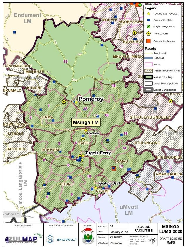
MSINGA LOCAL MUNICIPALITY: MTHEMBU TRADITIONAL SETTLEMENT MASTER PLAN

                                                                  INduna Nkulu – assists the inkosi in making decisions around matters and
                                                                  issues relating to the Tribal areas, they are usually the linking person
                                                                  between inkosi and izinduna, in addition they also govern a particular
                                                                  isigodi within the Traditional Council area.

                                                                  INduna – these are traditional leaders who report to iNduna Nkulu and
                                                                  iNkosi, each iNduna governs their own isigodi and oversees issues and
                                                                  matters concerning a particular isigodi.

                                                                  Map 2: Locality Map of Traditional Councils

                                                                  Although the study area is formed by wards as per the formal municipal
                                                                  demarcation process, it must be acknowledged that traditional areas have
                                                                  their own traditional ward structures called izigodi which have existed over
                                                                  time. These areas are not demarcated formally, however; the extent of
                                                                  these areas is common knowledge within the community in the area.

                                                                  In each Isigodi there is Induna who provides leadership on behalf of Inkosi;
                                                                  additionally, within the individual izigodi the induna is assisted by elders,
                                                                  with induna enkulu serving as chief advisor to the Inkosi and the former
                                                                  have been pivotal in ascertaining the boundaries of the study area. The

6|Page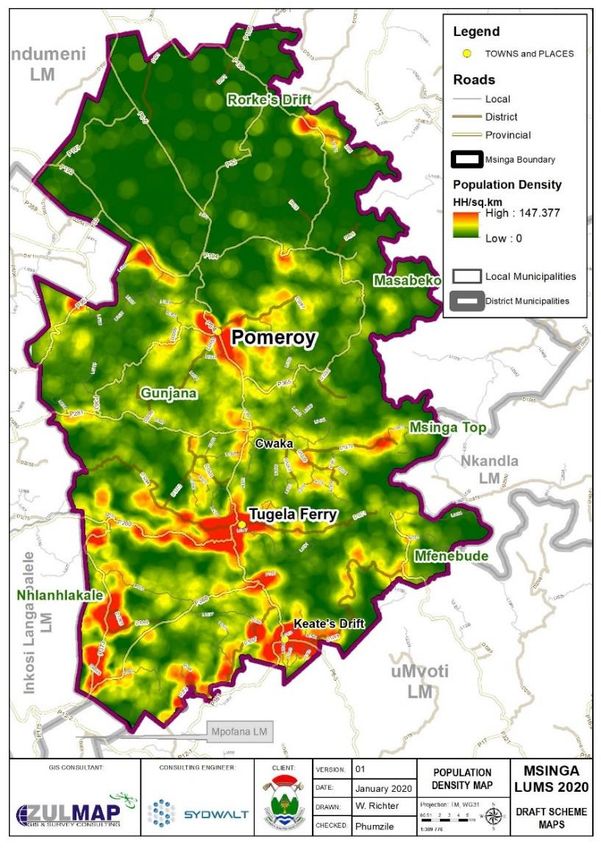
MSINGA LOCAL MUNICIPALITY: MTHEMBU TRADITIONAL SETTLEMENT MASTER PLAN

study area shares its boundaries with Ray Nkonyeni Local municipality and     Geographic Information Systems (GIS) and handheld Juno GPS units were
with the Eastern Cape Province.                                               used for the evaluation of the information and the conceptualisation of the
                                                                              framework.
5. THE PROJCET APPROACH AND METHODOLOGY
                                                                              It was that the communal choices of rural households and are as diverse as
Spatial development concepts are generally developed around urban
                                                                              those of urban households and this must be acknowledged. Different types
models that are then applied to rural areas. Notions such as corridors,
                                                                              of rural settlements have different development needs. Several denser
nodes and zones often dominate the spatial methodology in planning for
                                                                              settlements such as the aptly labelled, exhibition the traits of urban
both urban and rural areas, however, these concepts are unfitting within
                                                                              settlements however they may have a deficit economic base such as the
the rural context, especially without area specific planning interventions.
                                                                              location in Mthembu. On the other, the scattered or dispersed settlements
Consequently, in order to improve the community’s capacity to generate
                                                                              are sparsely developed rural settlements need basic infrastructure, for
their own income or means of living, the locally specific planning needs to
                                                                              instance, electricity, potable water and sanitation. The accessibility of
be the spatial focus in areas, like Mthembu. Furthermore, settlements
                                                                              natural resources is mostly determined by the local environment, the
need to be assessed by factors such as locality, social and economic access
                                                                              carrying capacity of the land, and the climatic conditions that either
as well as access to other basic amenities to determine the long-term
                                                                              impede or support the creation of livelihoods from the land. As a result,
sustainability and viability. This report utilises a combination of both
                                                                              this requires an adaptable approach that recognizes the multiplicity of
quantitative and qualitative research methods. The studies were
                                                                              locally specific needs in rural areas.
conducted through a field survey by means of capturing of proposed
development sites, engagements with the traditional council and               Department of Cooperative governance and traditional Affairs and the
community members and analysis of statistical data acquired from stats        Mthembu traditional council’s main goal is the development of a strategic
SA. In addition, has further been complemented by review of literature and    plan. Schemes such as strategic plans, general plans or master plans all
existing policy documents.                                                    depict similar ideas such as documenting the dreams, hopes, and
                                                                              aspirations a community holds for itself. Conversely, effectively capturing
The qualitative analysis fragment of the report has mainly been centred on
                                                                              the hopes of the community of becoming cultivated is a daunting
meetings with the Traditional Council and the respective provincial
                                                                              challenge. Although there are no universally accepted “one best way” of
government and municipal officials. A project plan has been employed as
                                                                              developing a Traditional Settlement Master Plan (TSMP), this part explains
a process plan to guide the study. This has been presented to the Mzinyathi
                                                                              the inclusive planning process that was exercised in preparing the
District Municipality the Msinga Local Municipality and later to the
                                                                              Mthembu Traditional Settlement Master Plan.
Mthembu Traditional Council to solicit buy – in into the study and
approach. The meetings conducted with the Traditional Council have            The comprehensive planning process verifies community goals and
assisted in collecting information about the contemporary practise of land    aspirations in terms of community development. The outcome of the
allocation and the long-term vision and objectives of the community.          comprehensive planning process is the Traditional Settlement Master Plan

7|Page
MSINGA LOCAL MUNICIPALITY: MTHEMBU TRADITIONAL SETTLEMENT MASTER PLAN

which dictates the aspirations of the Mthembu Traditional council in terms     to have developed rural settlements, where people will have better quality
of uses, land use, recreation and housing. The subsequent figure 1 shows       of life by providing them with clean water, electricity, security, better jobs
the steps that were taken in preparation of the aforementioned plan. The       and education. From the point of view of the NDP, rural areas are seen to
implementing and monitoring representatives are the Mthembu                    be a catalyst for agriculture development, and this will be achieved through
Traditional Council and the UMzinyathi District Municipality. As discussed     infrastructure and service delivery, investment in irrigation schemes and
before, it is vital for the two systems of governance at local level to find   security of tenure for communal farmers.
common ground and collaborate in decisions of land use and development
                                                                               Whilst this Traditional Settlement Master Plan does not intend to explicitly
management.
                                                                               deal with these priorities; by implication a systematic approach to land use
Figure 2: Comprehensive Planning Process                                       management in rural areas creates a favourable environment for
                                                                               investment in public infrastructure, which in turn will unlock various
                                                                               potentials within the area.

                                                                               6.1.2. THE SPATIAL PLANNING AND LAND USE MANAGEMENT ACT,
                                                                               16 OF 2013
                                                                               In terms of Section 155[7] and 44[2] of the Constitution of South Africa, the
                                                                               Spatial Planning Land Use Management Act 16 of 2013 [SPLUMA] was
                                                                               promulgated by Parliament as a uniform, efficient and comprehensive
                                                                               system of spatial planning that is applicable to the entire area of the
                                                                               Republic which is aimed at, amongst others, addressing the imbalances of
                                                                               the past by promoting social and economic integration of previously
                                                                               disadvantaged areas through Spatial Equity.

                                                                               Accordingly, SPLUMA identifies the following objectives that apply to
                                                                               “rural” and Traditional Council areas:

                                                                               -   Section 12 (1) (h): “include previously disadvantaged areas, areas
6. LEGISLATIVE AND POLICY PERFORMANCE MEASURES                                     under traditional Council leadership, rural areas, informal settlements,
6.1. THE NATIONAL CONTEXT                                                          slums and land holdings of state-owned enterprises and government
6.1.1. THE NATIONAL DEVELOPMENT PLAN                                               agencies and address their inclusion and integration into the spatial,
The National Development Plan (NDP) highlights rural development as one            economic, social and environmental objectives of the relevant sphere.”
of the country’s priorities. According to the NDP by 2030 the country looks

8|Page
MSINGA LOCAL MUNICIPALITY: MTHEMBU TRADITIONAL SETTLEMENT MASTER PLAN

-   Section 24 (2)(c): “include provisions that permit the incremental      The Municipal Systems Act (MSA) advocates for community participation
    introduction of land use management and regulations in areas under      in matters of development and that there must be consultative sessions
    traditional leadership, rural areas, informal settlements, slums and    with locally recognised Traditional Councils. As part of the Integrated
    areas not previously subject to a land use scheme.”                     Development Plan (IDP), a Spatial Development Framework (SDF) is also
        ✓ Identifying issues                                                developed and it includes the provision of basic guidelines for a Land Use
        ✓ Stating goals                                                     Management System. The Msinga Local municipality is in the process of
        ✓ Collecting data                                                   developing its wall-to-wall scheme; this plan is thus developed under the
        ✓ Preparing the plan                                                framework of both the Spatial Development Framework of the
        ✓ Adopting the plan                                                 municipality and the eminent Land Use Scheme. The intention of the plan
                                                                            would not be to supersede the Spatial Development Framework nor the
By extension, the Provincial Growth and Development Strategy (PGDS) is a
                                                                            wall-to-wall scheme; however, it is developed to enhance the Spatial
provincial tool that is used to identify key areas for investment and
                                                                            Development Framework and guide the allocation of land development
development in the form of a hierarchy of nodes as well as corridors that
                                                                            rights at a localised level.
form a network between the identified nodes to enhance the synergistic
movement of goods and services. For the most part these nodes and           The Municipal Systems Act also states that municipal services must:
corridors are focused on urban and peri-urban areas (given their
                                                                            (c) Be equitable and accessible:
concentrated settlement patterns) but due to their dispersed
arrangement, traditional settlement areas have had limited intervention.    (b) Be provided in a manner that is conducive to-
By and large the municipality and the professionals within the field of     (i) The prudent, economic, efficient and effective use of available
planning remains the practitioners and implementing agents of the acts.     resources; and
However; the act stipulates the importance of the participation of
Traditional Councils in land use management, as the planning instruments    (ii) The improvement of standards of quality in time;
i.e. the Spatial Development Frameworks and Wall-to-Wall schemes would      (c) Be financially sustainable;
also affect land under traditional leadership.
                                                                            (d) Be environmentally sustainable
6.1.3. MUNICIPAL SYSTEMS ACT, 32 OF 2000
The Municipal Systems Act (MSA) provides for the core principles,           However, it is not easy to achieve the above mentioned due to the current
mechanisms and processes that are necessary to enable municipalities to     nonresponsive settlement and land usage patterns. The traditional
move progressively towards the social and economic development of local     settlement master plan therefore will be a suitable tool to guide the
communities and ensure universal access to essential services that are      development and allocation of land thus unlocking the opportunities to
affordable to all.                                                          achieve the above-mentioned achievement of the above mentioned.

9|Page
MSINGA LOCAL MUNICIPALITY: MTHEMBU TRADITIONAL SETTLEMENT MASTER PLAN
6.2. THE PROVINCIAL CONTEXT 6.2.2. THE INGONYAMA TRUST ACT, 3 OF 1994
6.2.1. PROVINCIAL GROWTH AND DEVELOPMENT PLAN (PGDP) Approximately 2.8 million hectares of land in KwaZulu-Natal is Ingonyama
The KwaZulu-Natal Province has identified priority intervention areas Trust Land. The Ingonyama Trust was established in 1994 by the Ingonyama
presented in the KZN SDF presented in the PGDP (currently under review). Trust Act, to administer land in title for the benefit, material welfare and
As part of these priority areas, rural service centres are proposed which social well-being of the members of the tribes and communities.
will enhance rural development. These centres will include the following The Ingonyama Trust has all the rights to manage and be responsible for
activities: the running of the trust land. This means that local government has no right
- Traditional administration centre, to issue tenure rights on land vested under Ingonyama Trust. There are 3
- Taxi/ bus stop, types of tenure system within the traditional authority land, the long-term
- Informal trading / market area, lease, and the allocation of land for residential purposes. However; with
- Social facility (clinic, library etc.), the implementation of the traditional settlement master plan, it will give
- Skills development centre (mainly local schools), the land custodians better administration and management of the land by
- Mobile services point (mobile clinics, pension pay points, mobile library actively promoting the use of the provided developmental guidelines and
etc.), principles for efficient and sustainable land usage.
- Small commercial facility, and 6.3. THE LOCAL CONTEXT
- Recreational facility such as a sport field.
6.3.1. UMSINGA IDP AND SPATIAL DEVELOPMENT FRAMEWORK.
One of the strategic objectives of the PGDP is to unleash agricultural According to the 2020/2021 municipal IDP 99% of people within the
potential. However; there are constraints in achieving this goal which Mthembu Tc area, there is a lack of access to clean water, sanitation,
include inadequate access to funding for infrastructure and lack of agro- electricity and other services. This creates a barrier for market entry by
industries and therefore value-adding. Whilst there is a general belief that emerging businesses, and a backlog of water services. The IDP suggests
rural areas present themselves as opportune areas for agricultural that the Mthembu area is highly susceptible to high levels of rainfall.
development, agricultural potential for any rural area goes beyond just the Communal facilities are situated far away from the settlement and this
availability of land. There needs to be supporting infrastructure for the presents an opportunity to identify suitable land for the development of
agricultural activity to be viable. The study will present briefly an analysis these services within the TSMP.
of the area in this respect, though the focus will largely be on framework
guidelines for land allocation; which in turn can unleash any of the The 2019/2020 reviewed SDF identifies Mthembu TC area as a rural service
potentials that might be shown. node. As a result of to uMsinga’s rough terrain, the population is relatively
scattered, and services are concentrated along road infrastructure and
water sources such as the Tugela River and other rivers. Agriculture is the
main land use within the study area. The land extraction transpires short
10 | P a g eMSINGA LOCAL MUNICIPALITY: MTHEMBU TRADITIONAL SETTLEMENT MASTER PLAN
of the consideration of the carrying capacity of the soil. The effect of this in the west by uMtshezi and Indaka Local Municipalities. Within the
includes overgrazing therefore soil erosion and the degradation of the UMzinyathi District Municipality. The Municipality currently consists of six
environment. The SDF further states that Mthembu is characterised by traditional authority areas. These are namely Mthembu Tribal Authority;
land of high agricultural potential. Mabaso Tribal Authority; Ngome Tribal Authority; Mchunu Tribal
Authority; Bomvu Tribal Authority and Qamu Tribal Authority. The
The SDF also indicates that there were several housing projects within the
Mthembu Tribal Authorities is situated in wards 3 and 5.
Msinga, and one active housing project with the Mthembu TC projected to
yield 1000 units. The study area of Mthembu Traditional Council is located within the
jurisdiction of Umsinga Local Municipality in the western region of the
In terms of health facilities, the Mthembu area is serviced by gateway clinic
municipal boundary.
within the study area. It is apparent that the TC needs a police station to
be located within the TC. The Municipality of Msinga is situated in deep gorges of the Tugela and
Buffalo Rivers, secluded from the immediate neighbouring municipal
6.3.2. UMSINGA HOUSING SECTOR PLAN areas. There is a decline in urban areas and growth in rural areas as a result
The Msinga Municipal Housing Sector Plan denotes that the Mthembu TC of the population dynamics in Msinga, as opposed to most other areas in
comprises 1000 benefited in the second phase of the development. The the country. This may be a result of Msinga urban areas being very small
Mthembu rural housing projects cover wards 3, 4, 5 and 12 of the Msinga and are incapable of providing the normal range of goods and services
Local Municipality. The Municipality continues to develop its directive from provided in urban areas though Tugela Ferry appears to grow to a
the Human Settlements Provincial Department and pulls funding from substantial service centre in the municipality’s context (Msinga SDF
several implements granted for human settlements development. This is 2020/2021:6/7).
assumed by means of the delivery of low income housing and the
Municipality represents the ‘developer’ with Implementation Agents (IA) 7.2 SOCIO ECONOMIC PROFILE
employed to provide the housing and infrastructure needs of the 7.2.1 POPULATION GROWTH
settlement (Msinga Municipal Housing Sector Plan 2014:11). The information from STATS SA Census 2011 and Community Survey 2016
indicates an annual population growth rate of 1,226% per annum for the
7. STATUS QUO ANALYSIS period 2011 to 2016.
7.1 STUDY AREA Table 2: Population Growth
According to the Msinga SDF (2020/2021:6), The Msinga Local municipality
is located in the central part of the KwaZulu-Natal Province. The Msinga Gender Pop.2011 Pop. 2016 Pop. 2021 Pop.2030
Male 77 068 82 399 88 150 99 442
Local Municipality is located within the uMzinyathi District Municipality
Female 100 509 102 095 109 220 123 211
and is bordered in the North by Endumeni LM, in the east by Nquthu and
Total 177 577 184 494 197 370 222 653
Nkandla Municipalities, in the south by Umvoti and Mpofana Municipality,
11 | P a g eMSINGA LOCAL MUNICIPALITY: MTHEMBU TRADITIONAL SETTLEMENT MASTER PLAN Source: Stats SA 2016 Community Survey Map 3: Population Density According to Statistics South Africa 2016 census data, the population of uMsinga including Tribal areas consists of 184 494 people inclusive of 100,0% black Africans. The table below clearly indicates that 53.7 % of the municipality’s population falls in the age groups 0 to 18 years. Table 3: Age Groups Age Group uMsinga Under 18 53.7 % 99 069 18 to 64 41.6 % 76 664 65 and over 4.8 % 8 761 Total 100 % 184 494 This is a very young population that have serious implications for service delivery and the provision of (especially social) facilities in the municipal area. The implications of a young population in an area is high requirements for social services; educational and employment opportunities. The map below shows that the Mthembu TC is mostly sparely populated however, the lower ward 5 is densely populated along the P280 leading to Tugela Ferry. 12 | P a g e
MSINGA LOCAL MUNICIPALITY: MTHEMBU TRADITIONAL SETTLEMENT MASTER PLAN

7.2.2 HOUSEHOLD INCOME                                                      Figure 4: Employment Trends
In terms of average households’ income, majority of the community earns
in between R9, 601 – R 19 600 with 28, 9 % and the lowest earns between
R1 -R4, 800 with 7.7%. In addition those who have no source of income are
11.8 %. This signifies that most people have a source of income, however
very low to sustain the standards of living.
Figure 3: Household Income

                                                                            Source: Stats SA 2016 Community Survey

                                                                            7.3       LAND OWNERSHIP
                                                                            The IDP states that uMsinga Municipality has 18 wards and the 16 wards
                                                                            which are under traditional authority, are under the custodianship of the
                                                                            Ingonyama Trust Board (IDP 2020/21: 60).

Source: Stats SA 2016 Community Survey                                      The study area is a traditional area thus the traditional council is the
                                                                            overseer of the land. This means that individuals do not have full ownership
7.2.3 EMPLOYMENT TRENDS                                                     of the land that they reside on because they do not have title deeds over
The uMsinga Tribal areas experience significant unemployment with the       the land.
majority of people falling under the Non-Economically Active category
followed by Discouraged Work Seeker.                                        7.4        ENVIRONMENTAL ANALYSIS
                                                                            7.4.1 TOPOGRAPHY
                                                                            The nature of the topography is such that Msinga is largely located in deep
                                                                            gorges of the Tugela and Buffalo Rivers. This effectively isolates the area
                                                                            from the immediate surrounding municipal areas. Msinga Local
                                                                            Municipality area ranging from 405m (minimum) to 1726m (maximum)

13 | P a g e
MSINGA LOCAL MUNICIPALITY: MTHEMBU TRADITIONAL SETTLEMENT MASTER PLAN
Map 4: Topography above sea level. A complex topography (rolling hills and mountains) across
large sections of Msinga has an aesthetic appeal and holds considerable
tourism development potential (See Map 3). All areas steeper than 18
degrees should be excluded from development. This will not only protect
slopes from erosion and landslide risk but will ensure that ridges will
function as dispersal/habitat corridors. However, Steep topography causes
accelerated erosion, especially in the central and southern parts of Msinga
LM. Erosion control measures should be intensified in these areas by
means of intense agricultural interventions (including agricultural
extension programs and facilitation of transformation to sustainable
agriculture).
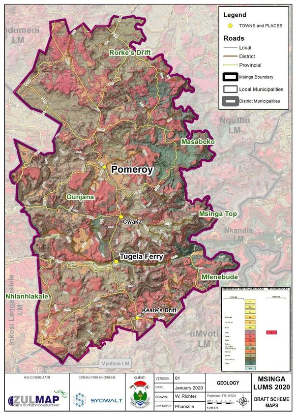
7.4.2 GEOLOGY
As the map below illustrates, Msinga Municipality consists of
conglomerate, dolerite, schist, shale, tillite, nsuze group, basalt, tonalite,
ecca group arenite, natal granite Arenite is the most common rock covering
the municipal area. Shale is also found through the area and Tillite is
present along the Buffalo River but only in the mountainous areas before
joining the Tugela River. These sedimentary formations are topped by
dolerite that is still exposed in the higher parts of the mountains
(uMzinyathi District Municipality, 2012).
14 | P a g eMSINGA LOCAL MUNICIPALITY: MTHEMBU TRADITIONAL SETTLEMENT MASTER PLAN
Map 5: Geology
7.4.3 ENVIRONMENTAL SENSITIVITY
The Mthembu Traditional Council area consists of a number of Optimal
Critical Biodiversity areas which requires protection from development. In
addition the area contains Ecological Support Area (ESA): Species Specific
and major wetlands around the border of the Traditional Council (See Map
5).
15 | P a g eMSINGA LOCAL MUNICIPALITY: MTHEMBU TRADITIONAL SETTLEMENT MASTER PLAN
Map 6: Environmental Sensitivity 7.4.4 RIVER CATCHMENT
The Municipality has the fourth level (quaternary) catchment areas that
drain into the Tugela and Umvoti Rivers. Blood River feeds into the Buffalo
River that is the main tributary that drains the northern part of the
Municipal area. The Buffalo River flows into the Tugela east of Ngubevu
from where the Tugela forms the boundary between Msinga and Nkandla.
The Mooi River flows into the Tugela at Keate’s Drift.
7.5 HOUSING
According to site visit observations, it was established that the primary
dwelling types are traditional houses and RDP Housing. On the other hand,
the typology of houses are not limited to the above-mentioned, as surveys
indicate that modern structure of housing emerging.
Image 1: Housing typologies
7.6 SOCIAL FACILITIES
7.6.1 EDUCATIONAL
The study area has educational facilities such as primary and secondary
schools, which are readily available. These facilities are relatively close to
community houses, this makes it easier and cheaper for learner to get to
16 | P a g eMSINGA LOCAL MUNICIPALITY: MTHEMBU TRADITIONAL SETTLEMENT MASTER PLAN
schools. The location of the facilities encourages sustainable human 7.6.2 COMMUNITY HALL
settlement in the community of Mthembu (See Map 6). The Mthembu TC has three halls at its disposal, two of which are school
halls as demonstrated in Map 7. In addition, the existence of these
Map 7: Educational Facilities
community halls promotes social engagement.
Map 8: Social facilities
17 | P a g eMSINGA LOCAL MUNICIPALITY: MTHEMBU TRADITIONAL SETTLEMENT MASTER PLAN 7.6.3 PLACE OF WORSHIP Map 9: Health Facilities The Mthembu community does have a physical church building along the main road P280, and it is perceived that the existing halls are also used as churches and for other religious gatherings. 7.6.4 HEALTH CARE According to the land-use survey taken in the Mthembu TC, there was a single clinic recorded within the community and the entire community is served by that clinic and the hospital located in adjacent area (See Map 8). 18 | P a g e
MSINGA LOCAL MUNICIPALITY: MTHEMBU TRADITIONAL SETTLEMENT MASTER PLAN

7.6.5 LOCAL ECONOMIC DEVELOPMENT                                           7.6.7 LAND USE AND SETTLEMENT PATTERN
There were numerous formal and informal businesses identified that         The Mthembu area is mostly rural in nature. These settlements have
operate within the Mthembu Community. The type of local businesses         several commercial and social activities which are taking place within the
found are mostly shops that sell food and small everyday domestic items.   community. Commercial activities are not limited to small local convenient
There are about two hardware stores, a shopping mall and a carwash. The    shops but also include hardware stores, a carwash and a mixture of landuse
availability of the tuck shops and supermarkets within easy reach of the   near the shopping mall. The TC is also serviced by multiple municipal offices
community.                                                                 such as the Social Development office and a library. There is also medium-
                                                                           scale manufacturing activities such as ploughing fields. The surveys
          Image 2: LED
                                                                           revealed that the housing pattern was not formally structured, community
                                                                           members built their houses along the roads and rivers, for convenience.

                                                                           7.7.1 WATER AND SANITATION
                                                                           According to the IDP, uMsinga local Municipality is not the Water Service
                                                                           Authority (WSA), as the uMzinyathi District Municipality is responsible for
                                                                           provision & maintenance of water and sanitation. The water backlog is
                                                                           subjected in nearly all areas within the Municipality. The water backlog is
                                                                           still high; however the district has invested a considerable amount to
                                                                           address the backlog (Msinga IDP 2020:138-139).

                                                                           Within the Mthembu TC, the uMzinyathi District Municipality supplies the
7.6.6 ROAD INFRASTRUCTURE                                                  water and the study area consists of water storage.
The road infrastructure within the settlements consists of gravel roads,   7.7.2 ELECTRICITY INFRASTRUCTURE
which means that the types of roads found in this area are unpaved road
surfaces with gravel that has been brought to the site from quarry. This   According to the IDP, the uMsinga Municipality is not qualified to deliver
means that the area is less developed.                                     electricity; and so, Eskom is the only service provider (Msinga IDP 2020:
                                                                           58). Some parts of the area does have Eskom lines running in the areas, so
Image 3: Gravel Roads
                                                                           the traditional authority does have access to electricity infrastructure.

19 | P a g e
MSINGA LOCAL MUNICIPALITY: MTHEMBU TRADITIONAL SETTLEMENT MASTER PLAN
7.8 STATUS QUO SWOT ANALYSIS 8. KEY DEVELOPMENT CHALLENGES
Table 4: SWOT A study showed that the community of Mthembu is confronted with major
STRENGTHS WEAKNESS development challenges. The key challenges that were highlighted are as
- The Msinga Municipality - Lack of proper Land use Management follows:
and TC work Practices
- High levels of poverty;
progressively together - High Crime Levels
- Lack of health, social and educational - Dispersed settlement Patterns;
- Population focused along - Lack of access to decent housing ;
facilities
access routes, rivers and - Poor public transportation system;
- Long walking distance to secondary schools
streams
- Preservation of Environmental Significant - Lack of proper sanitation, for instance many households use
- Availability of unimproved pit toilets;
Land.
educational facilities is - Unemployment/ Lack of job opportunities - There are no high schools within a radius of 5km, for instance, in some
well provided - Poverty of the areas within the TC ,the nearest high school is more than an hour
- Agriculture potential - Child-headed households and a half walk away from the settlement;
- Teenage pregnancy and other socio- - Lack of proper waste disposal as households dispose of their garbage
economic issues within their yards (burning of waste);
OPPORTUNITIES THREATS - Lack of access to a reliable water supply, especially with the prominent
- Agricultural arable Land - Lack of protection of Environmental drought;
Significant Land may hinder Future Toursim - Limited access to further education and training facility for scholars;
- Availability of land
Opportunities - no clinic within some of the areas, in some cases, the nearest clinic is
- Municipal training
- Vegetation or availability - High Crime levels may lead to population more than an hour’s walk away from the settlement in some areas; and
of traditional herbs decline. - Limited agricultural land with good potential
- The lack of well-planned roads
8.1 OUTCOMES FROM THE PUBLIC CONSULTATION
- No vision to guide community - The TC acknowledged that they are agricultural area and potential
- Possible future migration development area.
- Undevelopable land - There are high levels of pollution due to the dumping of used nappies.
The TC feels that the smell coming from the water is due to these used
- Scattered settlements with no key economic
nappies which is also being consumed by cattle.
centres might delays future development
- Initially they were told to locate their houses near ‘potential communal
agricultural land, however these agricultural parcels were neglected
20 | P a g eMSINGA LOCAL MUNICIPALITY: MTHEMBU TRADITIONAL SETTLEMENT MASTER PLAN
and not much intervention was made in improving and maintaining unemployment. The reasons for this is, there is a high percentage of
them. community members with a low rate of educational background and as a
- TC Council requested that the municipal officials look at their land. result, these members have limited employment opportunity, hence, the
- Izinduna proposed that in the near future, the municipality should increase in unemployment.
conduct a comprehensive appraisal of the land quality in each tribal
The Mthembu TC aspires to do extremely well in providing service delivery
authority.
and good governance to all its people that have pride in agriculture and
- Currently there are houses located on the riverbeds, due to locational
community development.
advantage (Source of water).
This goal is informed by the projects that have been identified within the
8.2 PROPOSALS GOING FORWARD respective localities as they exhibit the intended growth by the TC.
- They will have an opportunity to show these areas on an arial map,
which we will cross examine with our Overlay maps. 9.2 APPROACH TO DEVELOPING GOALS, STRATEGY & PLAN
- Nappies are a refuse issue, but more importantly a health issue which One of the most significant aspects in the forward planning component of
should be prioritised, to avoid pollution of such nature, especially near the municipal SDF is the identification of Mthembu TC as a rural service
rivers. node. The implemented method was used to determine the alignment
- The relevant department should intervene and provide alternative between the TSMP vision and goals and the aim of the current municipal
interventions to resolving neglected communal areas. spatial plans specifically, IDP/SDF further aligning to the PGDS will be used
- Strongly evident along rivers that traverse the major town of Tugela to attain the TSMP development goals.
Fairy. Result of migration patterns to locate near better economic
opportunities. There is currently a roll out of IDP houses within Msinga,
the people with houses along riverbeds, should be priority number one Figure 5: Strategic Plan
Challenges
for relocation.
- Major developments are encouraged to undergo certain quality checks
Core Issues
prior to development. It’s out of the municipality’s jurisdiction,
however if the tribal council demand these checks, and requests for
the municipalities intervention, such issues could be redressed. Goals
9. SPATIAL CONCEPT & STRATEGY Scheme
9.1 MTHEMBU TC VISION
It was established, during the engagement with the Mthembu TC, that the
high level of dropouts is linked to the growing level of youth
21 | P a g eMSINGA LOCAL MUNICIPALITY: MTHEMBU TRADITIONAL SETTLEMENT MASTER PLAN
9.3 MTHEMBU DEVELOPMENT STRATEGIES such land is conserved and delineated to avoid encroachment of rural
The purpose of the TSMPs is not to amend the existing spatial structure, settlement on it.
but rather to guide future development towards a better, more efficient
9.3.4 PROTECTION OF ENVIRONMENTALLY SENSITIVE AREAS
and more cost-effective settlement structure. In other words, the faults of
The land uses in Tribal Landform traditionally without proper planning and
the spatial structure should be tackled through the development planning
land use management practices. The environmental momentous land such
of its potential growth. The following strategies can be employed to
as, nature reserves, wetlands and regions with ecological species that
achieve;
might attract tourists and usually drives rural tourism. The preservation of
9.3.1 ENCOURAGE MIXED LAND USES such land is fundamental for both sustainable development and future
Rural settlements are usually located far from social services, this results in tourism opportunities.
high transportation costs for the people living in these areas to access
9.4 PROPOSED LAND USES
these services. It is essential that within a rural area, a number of economic
Crèche: the delivery of these facilities within the study area will promote
and social uses are integrated together to form a rural investment node.
child development as well as care for children to encourage youth social
This will attract private investment and municipal service delivery.
sustainability
9.3.2 IMPROVE TRANSPORTATION CONNECTIVITY
Primary school: ensure the development of children and to promote social,
The vision of the TSMP is to improve accessibility to key service areas for
cultural and academic skills.
its community. Public transportation costs make up a large proportion of
household expenditure due to services being located faraway from rural Community hall: this facility will promote communal engagements and
settlements. Land use development and public transportation are provides the community with the means to assemble and get together for
interrelated and as a result affect each other. Development corridors bring community activities and other uses.
about the ideal land use structure for the cost-effective utilisation of public
transport systems, within rural landscapes. The most effective public
transportation system is a linear pattern system, for instance, a settlement
with a linear land use pattern will benefit commuters, as it suggests that
residential settlements infolds the corridor road placing commuters within
short walking distances to the available public transportation.
9.3.3 PRESERVATION OF AGRICULTURAL LAND
Agriculture may be the most crucial value chain in the Mthembu area as
well as the uMsinga Local Municipality. For that reason, it is crucial that
22 | P a g eMSINGA LOCAL MUNICIPALITY: MTHEMBU TRADITIONAL SETTLEMENT MASTER PLAN
Map 10: TSMP Concept
10. IMPLEMENTATION FRAMEWORK
10.1 MONITORING & EVALUATION
Elements such monitoring, evaluation, reporting and adaptive
management are broadly accepted as the central components for efficient
municipal planning. This often takes the form of a Performance
Management System (PMS) and forms an integral part of the IDP. Likewise,
monitoring and evaluation of the impact of the TSMP should not be
considered as a once-off and separate task, but as an on-going process that
forms part of the overall assessment of the performance of the
municipality. This also assists to classify characteristics or components of
the SDF that need to be amended or reinforced, and therefore keeps the
SDF relevant to the strategic spatial agenda of the municipality.
The evaluation of the impact of the SDF seeks to determine whether its
operational mechanisms support realisation of the objectives. It will look
at activities, outputs, and outcomes, use of resources and causal links. This
improves the efficiency and efficacy of operational processes. The
evaluation and monitoring framework will measure changes in outcomes
(and well-being of target population) attribute to a specific intervention. It
will inform high-level officials on extent to which intervention should be
continued or discontinued, and if any potential amendments are needed.
The monitoring and evaluation framework to be used to measure the
implementation of the proposals made in the Mthembu TSMP is illustrated
on the Table below.
23 | P a g eMSINGA LOCAL MUNICIPALITY: MTHEMBU TRADITIONAL SETTLEMENT MASTER PLAN
Table 5: Monitoring and Evaluation Framework
Key Challenges Primary Causes Objectives Key Actions Responsible Department/Resolving Agent
1. Lack of Water - Lack of land management in rural settlements. - A community with improved - Identify and promote alternative - Msinga LM
access to improved water infrastructure solutions within landscape
Provision
- Large distance between households in rural provsion of municipality. - UMzinyathi DM
settlements.
- Provision of cost effective services which - Department of Human Settlements
- The physical landscape/ terrain plays an integral can be maintained
part in determining settlement patterns or the - Community members
line of roads which needs to be built and makes - Ensure that LED projects are located
water provision costly. where its sustainability is ensured and in
areas of greatest need.
2. Unemployement - Lack of educated youth - A community with improved - Provision of Youth training and skills - Msinga LM,
exposure and access to development programmes
- Lack of Skills Development programmes & improved social facilities - Department of Education
Facilities - Improve the Qaulity of Education,
Awareness and education on Satellite - Community members
- Lack of job opportunities librarie
- Inadequate access to information (Internet &
libraries)
3. Lack of private - Poor land use management procedures - Attract private investments - Improved provision of economic - Msinga LM
infrastructure to attract investors.
Investment
- Lack of municipal Service delivery - EDTEA
- Develop a strong public & private
- Poor road infrastructure and accessibility to partnership in rural tourism - DOT
economic centres development.
4. Land-use - Participation of traditional leaders in municipal - Provide proper land regulation, - Improve land allocation processes in line - Msinga LM
processes and partnership with Msinga local zoning and land management with municipal by-law
management
municipality. - Mzinyathi District Municipality
- Zoning, geo-referencing of rural land
documentation and enforcement of - COGTA
traditional settlement practices
- Mthembu Traditional CouncilPrepared By:
11. REFERENCE LIST
SYDWALT (PTY) LTD
Republic of South Africa .1998.National Environmental Management Act
No. 107 of 1998.
Republic of South Africa. 1994. Kwa-Zulu Ingonyama Trust Act, 1994.
Government Gazette. Pretoria.
Republic of South Africa. 2000. Municipal Systems Act, 32 of 2000.
Republic of South Africa. 2012. KZN Provincial Growth and Development Address: Head Office Johannesburg
Strategy and Plan. 2 Morris Street
Rivonia, 2191
Republic of South Africa. 2013. Spatial Planning and Land Use
P.O. Box 201, Kyalami, 1683
Management Act No 16 of 2013. Government Gazette. Pretoria.
Website www.sydwalt.co.za
Republic of South Africa. National Development Plan 2030 Our Future-
Make It Work. Contact Person Dumisani Nxumalo (Business
Development Director)
Republic of South Africa.1996.Constitution of the Republic of South Africa
Sandile Ntobongwana
No. 108 of 1996.
(Professional Town and Regional
uMsinga Local Municipality.2014. Final Draft Report- Msinga Local Planner)
Municipality: Housing Sector Plan. September 2014.
uMsinga Municipal Integrated Development Plan 2020 – 2021 Review. Contact number +27 10 442 4795
Cell number +27 76 342 5797
uMsinga Municipal Spatial Development Framework- Draft Status Quo +27 84 317 3186
Report. June 2020
Watson, V. 2009. ‘The planned city sweeps the poor away…’ Urban Fax Number 086 607 2438 (RSA Only)
planning and 21st century urbanisation. Progress in planning, 72 (3): 151- Email Dumisani@sydwalt.co.za
193. Sandilentobo@gmail.comYou can also read