Joint water management of the Finnish-Norwegian river basin district (2016-2021) - Tana, Neiden and Pasvik catchment areas in Finland and Norway ...
←
→
Page content transcription
If your browser does not render page correctly, please read the page content below
Joint water management of the Finnish-
Norwegian river basin district (2016-2021)
  Tana, Neiden and Pasvik catchment areas in Finland and Norway

               www.ymparisto.fi │www.vannportalen.no

                                                         Lake Inari, Aarno Torvinen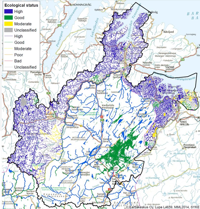
The Finnish-Norwegian River Basin District
On 22 of May 2014, a bilateral agreement aiming at fulfilling the requirements of the Water
Framework Directive (WFD) entered into force. The agreement designates the four catchments
Tana, Neiden, Munkelva and Pasvik as an International River Basin District (IRBD). The purpose
of the agreement is to establish a common framework to secure a stronger bilateral cooperation and
coordination between the River Basin Authorities (Finnmark County Council and ELY-Centre of
Lapland). The agreement covers the planning and implementation of River Basin Management
Plans (RBMP) and Programmes of Measures (PoM). Detailed procedures for the coordination are
laid down in a Memorandum of Understanding attached to the bilateral agreement. The
Memorandum states that a common Roof Report for the whole international river basin district must
be produced in order to meet the requirements of the WFD, in the form of a comprehensive
“executive summary” of the two national RBMPs. Meetings between the two countries’ River Basin
Authorities commenced in 2013, aiming at the production of a common Roof Report for the whole
IRBD in 2015.
This document is available in Finnish, Norwegian, Sami and English. The document, along with
further information and regional river basin management plans, can be accessed at:
www.vannportalen.no/norsk-finsk
www.ymparisto.fi/vaikutavesiin
2
Table of contents

  1. Introduction and background ................................................................................................... 4
  2. Area description ....................................................................................................................... 5
  3. Public information and consultation ........................................................................................ 9
  4. Significant water management issues and pressures identified ............................................... 9
  5. Monitoring networks .............................................................................................................. 12
  6. Assessment of water bodies ................................................................................................... 13
  7. Environmental objectives and exemptions............................................................................. 20
  8. Protected areas in the river basin district ............................................................................... 22
  9. Joint programme of measures ................................................................................................ 25
  10. Economic analysis of water uses ............................................................................................ 28
  11. Effects of climate change in relation to the water framework directive ................................ 28
  12. Future challenges.................................................................................................................... 29
  13. Related documents ................................................................................................................. 30
  14. References .............................................................................................................................. 31
  Appendix I. Coordination meetings between national authorities ................................................. 32
  Appendix II. Monitoring maps....................................................................................................... 33

                                                                                                                                                3
1. Introduction and background
According to article 3 of the Water Framework Directive (WFD), river basins covering the territory
of more than one Member State shall be assigned an international river basin district. In order to
comply with the WFD and national legislation, Norway and Finland signed an agreement
concerning a Finnish-Norwegian River Basin District. The agreement sets the framework for
bilateral cooperation and administrative arrangements for the river basin district. The agreement
encompasses Tana and Neiden water districts, Munkelva with tributaries, and Norwegian and
Finnish territory in the Pasvik water district. A Memorandum of Understanding pursuant to the
Agreement has also been produced, which addresses the procedures for the coordination of the
water management in the Finnish-Norwegian River Basin District at a more detailed level.

River Basin Management Plans are an important tool for securing and improving the status of our
aquatic resources. The management plans are intended to summarise the ecological and chemical
status of the water bodies, set environmental goals and form a base for local, regional and national
authorities’ activity, by administering water resources with a holistic approach. This jointdocument
is a summarising and comparative appendix to the national river basin management plans for the
Finnish-Norwegian River Basin District. An agreement between the two countries was signed in
2013, effectively creating an international river basin district that encompasses Tana, Pasvik and
Neiden water basin districts. Prior to the agreement, the water districts that now form the
international river basin district had been administrated as part of Finnmark River Basin District in
Norway, and as Tana, Neiden and Pasvik River Basin District in Finland. At the time of public
consultation of the documents it had not been possible to produce a common management plan for
the international river basin district, due to differences in organisation and methodology.

The regional authorities Finnmark County Council, the Office of the Finnmark County Governor
and Lapland ELY-centre (Centre for Economic development, Transport and the Environment) have
had meetings periodically since 2011 to coordinate and set common goals for water management.
The meetings have addressed delineation of water bodies, the methodology behind characterisation,
classification and risk assessment, and which level of coordination can be attained for the river
basin management plans, programmes of measures and monitoring programmes (Appendix I). In
addition, yearly meetings for all the river basin districts in northern Scandinavia (North Calotte)
have been held to exchange information and better coordinate processes. Meetings at the local level
have also been held between municipalities in Norway and Finland.

Cooperation between Finnish and Norwegian authorities regarding water management predates the
WFD. In 1980, the Norwegian and Finnish government signed an agreement concerning The
Finnish-Norwegian Transboundary Water Commission 1 , ensuring local, regional and national
cooperation regarding the transboundary watercourses. The commission remains as an important
arena for discussion and input in relation to the WFD.

1
    http://www.ymparisto.fi/fi-fi/Vesi/Vesiensuojelu/Rajavesistoyhteistyo_Lapissa/Suomalaisnorjalainen_rajavesistokomissio [in Finnish]
    http://fylker.miljostatus.no/Finnmark/Tema-A-A/Internasjonalt-samarbeid/Grensevassdrag/ [in Norwegian]

                                                                                                                                          4
2. Area description
Geographical and ecological description
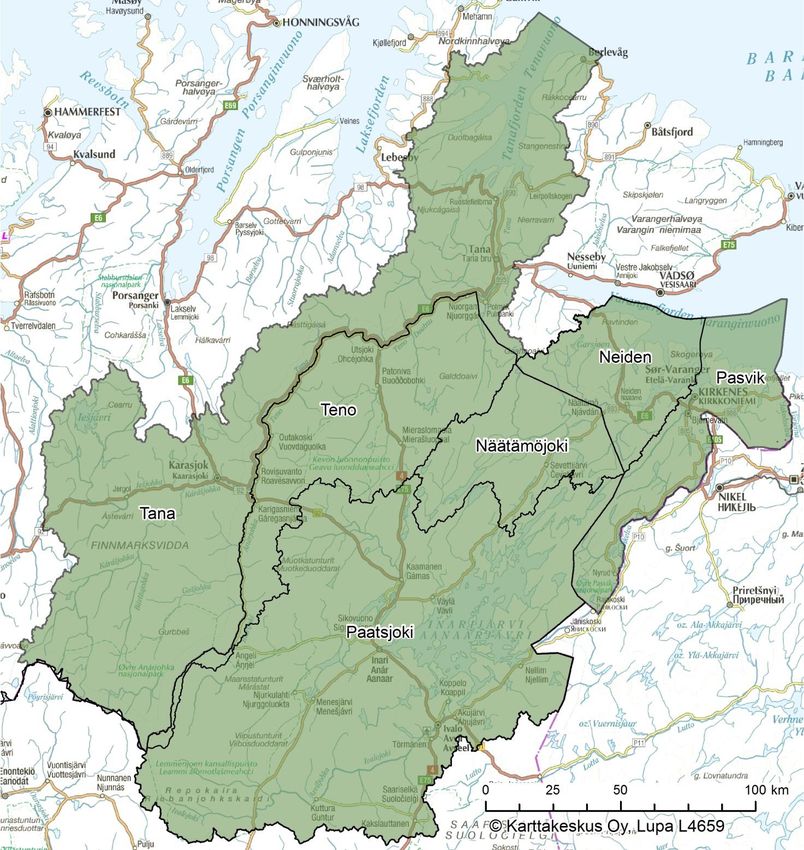
The Finnish-Norwegian River Basin District is composed of Tana, Neiden and Pasvik water
districts. While Tana and Neiden cover territory in Norway and Finland, Pasvik water district also
stretches into Russia (figure 1). However, Russia is not part of the agreement concerning the
international river basin district.
The Finnish-Norwegian River Basin District covers the catchments for the rivers Tana, Neiden,
Pasvik and Munkelva, which drain into the Barents Sea. The total land area of the river basin is
roughly 48 000 km², with roughly two-thirds located in Finland. The area is sparsely populated and
there are only a few bigger towns in the area. The population on the Finnish side of the area is
roughly 8000 and the population density is 0.3 people/km2. There are roughly 20 000 inhabitants
living on Norwegian side of the river basin. This results in few influences for a majority of the
water bodies in the river basin district, and thus the ecological status is high or good for most of the
area. Most of the river basin district area belongs to the Sami native region.
The river basin district belongs to the Fennoscandia shield on the Finnish side, and a small part of
the Tana River basin area belongs to the Caledonia mountains bio-geographical region on the
Norwegian side. The Pasvik River basin area is divided into the western and southern mountain
areas, and a more shallow Lake Inari area. Altitude differences in the mountain area are large,
ranging from 150 to 600 m above sea level. The area around Lake Inari is hilly, where the altitude
varies from 100 to 200 m above sea level.
Moraine is the most common soil type in the river basin district. Vegetation is sparse in many parts
of the area, and outcrops are abundant. In the valleys (e.g. River Tana and Utsjoki valleys) there are
ridges and deltas. Large sand deposits are formed in the rivers, which have dug out various levels in
the sandy river terraces, which are used for cultivation and settlements. The bedrock varies from
sandstone to granite and gneiss rock. The land is characterised by moraines, valleys with sandbanks
and terrace surfaces, and vegetation varying from barren mountains and plains to pine forests and
large marshy areas. The Pasvik water district borders the Siberian Taiga forest. The Tana water
district is formed of the same geological rock formation as the rest of Northern Finland like granite
gneiss, slate and abyssal rock areas. As a result of the rock formation and its acidic nature, which
can be seen also in the soil, the vegetation is typical for that kind of selective environment.
Apart from the Pasvik River, the aquatic environment in the area is typically nutrient-poor and
clear, and waterbodies contain very little organic matter. The watersheds are rich in species both in
terms of vegetation, fish, birds and mammals. The biggest rivers in the area are Tana, Karasjohka,
Anarjohka, Neiden, Utsjoki, Vaskojoki, Ivalojoki, Juutuanjoki, Pasvik and Munkelva. Most of the
lakes located in the area are alpine (fjäll) lakes or small or midsized nutrient-poor lakes.
5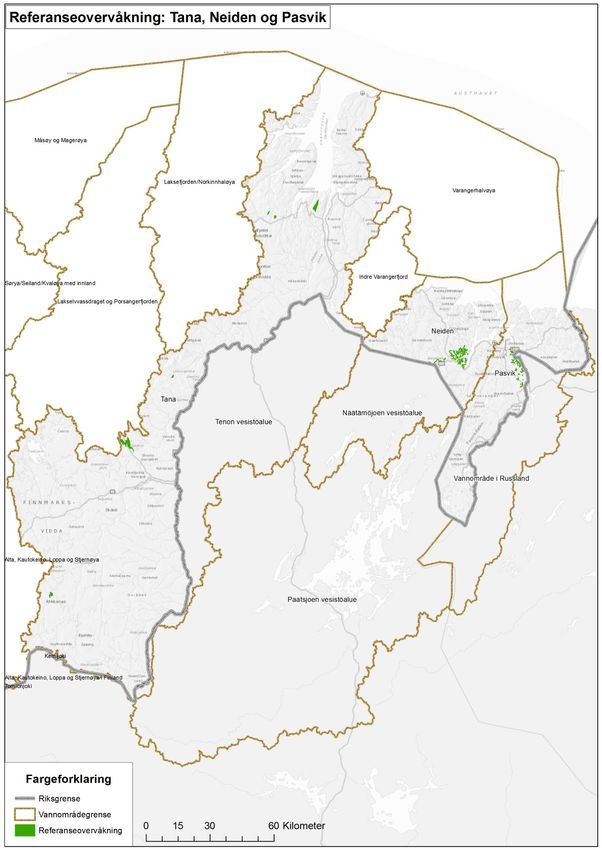
Figure 1. Overview of the Finnish-Norwegian river basin district and its administrative borders: Tana-Teno
river basin, Neiden-Näätämöjoki (including Munkelva-Uutuanjoki) and Pasvik-Paatsjoki river basin
(excluding the Russian part).

The biggest lake in the area is Lake Inari, from which the waters run into the Barents Sea along the
Pasvik River. The waterbodies in Norway are grouped into eco-regions based on climatic conditions
and bio-geographical distribution patterns. The Norwegian side of the river basin district belongs to
the Inner Northern-Norway eco-region, which has more fish species than other regions due to a
distinct migration history.

                                                                                                        6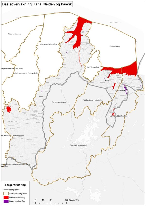
Water dominates the landscape in the Finnish-Norwegian River Basin District. Table 1 shows the
number of water bodies in the river basin district, as well as their combined area or length.

Table 1. Water bodies in the Finnish-Norwegian River Basin District (as of 18.01.2016).
                            Rivers                 Lakes          Coastal waterbodies        Groundwater
Water Category
                   Amount     Length (km)    Amount Area (km2)   Amount Area (km2)        Amount Area (km2)
Norway    Tana        506          14 193       156        248       20          1072         31         231
          Pasvik      116             2677       89        186       10          1884          7          18
          Neiden       85             2764       55         73         7           107         2           8
Finland   Tana         39              967       46         63         -              -
          Pasvik       66            1 475      184      1 550         -              -      397        304
          Neiden       18              234       76        176         -              -
Total                 830          22 310       606      2 296       37          3063        437        561

The waterways in the river basin district are of great importance for the Sami culture and all
settlement. Rivers and lakes enable livelihoods such as agriculture, forestry, fishing, hunting and
industry, as well as leisure activities. There are several national parks and nature reserves in the
area. Several of the rivers in the river basin district are important spawning rivers for Atlantic
salmon; Tana is one of Europe’s largest salmon rivers. There are special protection regimes for
protecting the salmon stocks in the national salmon fjords and rivers in Norway. The delta of the
river Tana is also Northern Europe’s largest river delta, and carries high importance for wetland
birds.

Environmental influences from human activity in the river basin district include nutrient loading,
hydropower and other physical alterations of watercourses (including fish migration barriers), alien
and invasive species, and pollution. Sources of pollution include both point sources and diffuse
sources, such as wastewater, industry, and leaching from landfills, disused industrial areas and
mining sites. The Norwegian part of the river basin also has polluted sediments in most harbours.
Nutrient loading from human activities is rather small in the area and the ecological status is mainly
classified as good or high. Sources of nutrient loading can be forestry, wastewater (both from
households and municipal wastewater), agriculture and other diffuse sources.

Two lakes, Inari and Rahajärvi, are regulated for hydropower production on the Finnish side.
Hydropower on the Norwegian side includes the Kongsfjord watercourse, the Pasvik watercourse
and the Kobbholm watercourse, as well as several rivers and lakes in water district Neiden. Several
watercourses on the Norwegian side of Tana water district are protected against hydropower.

The biggest pollution source in the area is Norilsk nickel plant in the Russian town Nikel, located
just 7 km from the Norwegian border. The plant emits roughly 100 000 tons of SO2 along with
other heavy metal emissions (nickel and copper) to air- and waterways. Wastewater is released to
the Pasvik River watercourse via Lake Kuetsjärvi. Due to the prevailing southwestern winds, the
airborne emissions tend to be carried northeast of the source. The pollution has affected water
quality in several waterbodies, mainly in the lower Pasvik River basin and in the Norwegian
Jarfjord area. In addition there is significant pollution from mining and industrial activity in the
Pasvik water district, where the mining company Sydvaranger Gruve AS has a discharge permit for
Bøkfjorden. Food safety warnings have been issued for certain lakes in the Sør-Varanger

                                                                                                          7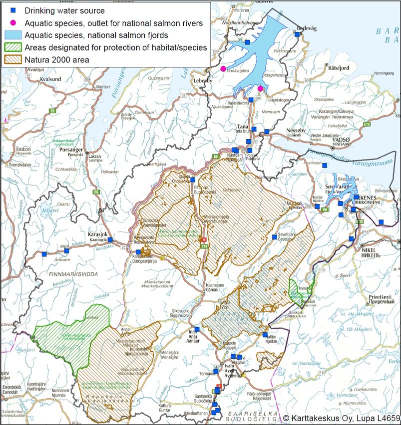
municipality because of dioxin pollution from ore processing (Enge et al. 2003; Mattilsynet 2015).
There is no actual industry on the Finnish side of the border, but there are several small salmon and
reindeer meat processing plants located in the municipality of Utsjoki.

Management structure
In Norway, the river basin districts are managed by the County Councils, which are appointed
competent authorities in the Water Management Regulation, §20. The competent authority is
responsible for facilitating and coordinating the processes behind producing a river basin
management plan, a programme of measures and a monitoring programme. The Office of the
County Governor is appointed as the environmental authority for each river basin district. A River
Basin District Board is appointed, with representatives from regional sector authorities, the Office
of the County Governor, the County Council, municipalities and other affected authorities. If the
river basin encompasses several County Councils, a steering group is appointed, however this is not
the case in Finnmark County. Public participation and involvement is secured by inviting other
stakeholders and interest-organisations to participate in regional and local references groups.

Municipalities in the water districts are encouraged to organise the local work in an inter-municipal
project, where one municipality takes responsibility for the coordination and local processes. A
Water District Board is also appointed, consisting of the involved municipalities at the political and
administrative level, regional sector authorities and other stakeholders. A local reference group is
often merged with the water district board to create better conditions for participation and
strengthen local involvement. For Tana water district, Tana municipality leads the work, while Sør-
Varanger municipality is responsible for Pasvik and Neiden water districts.

All documentation, updates, contact information, and minutes from meetings are available at
www.vannportalen.no/norsk-finsk.

Finland´s ELY-centres are responsible for the planning of river basin management in their
respective districts, with one centre appointed to co-ordinate the management of each of the seven
river basin districts. The ELY-centre has set up cooperation groups, whose members include invited
representatives of the main regional and local authorities, municipalities, organisations, landowners
and business interests responsible for the use, protection and state of water bodies.

All documentation, updates, contact information, and minutes from meetings are available at
www.ymparisto.fi/vaikutavesiin.

                                                                                                    8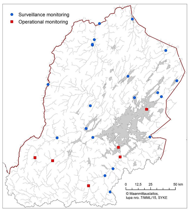
3. Public information and consultation
Public consultation and information is important in order to ensure participation and secure local
knowledge. The management plans for the river basins are published for public consultation for a
period of six months.

There are differences in the timetables in Norway and Finland. The public consultation period in
Norway was from the 1st of July to the 31st of December 2014. During the public consultation
period a national public consultation conference was held, as well as regional and local information
meetings. During the first part of 2015 in Norway the results of the public consultation were
processed, and alterations and updates to the management plan were made. This entailed meetings
for the River Basin District Board, working groups if necessary, and meetings with the regional
reference group, which consists of interest organisations and other affected parties. The
management plan will then be submitted for approval in the River Basin District Board and then
submitted to the Finnmark County Council for political approval. The plan was approved by the
Finnmark County Council 9.12.2015.

The public consultation period in Finland lasted from the 1st of October 2014 till the 31st of March
2015. Results from the public consultation were processed during 2015 in co-operation with
stakeholders and authorities. Two separate documents will be processed, the water management
plan and a program of measures, which is a more detailed document on water management
measures. The water management plan was approved by the Finnish government 3.12.2015.

The Finnish water management plan draft was translated into Norwegian, and the Norwegian
documents were translated into Finnish. The translated documents were linked on both authorities’
consultation web pages.

This joint report will be presented as an unofficial appendix to the respective national river basin
management plans.

    4. Significant water management issues and pressures identified
The European Water Framework Directive requires that significant water management issues in the
river basin districts are mapped, at least two years prior to the period to which the management
plans refer. Both Finland and Norway have prepared a document defining and summarising the
significant pressures and impacts of human activity in their respective river basins. The summary is
based on the characterisation of the water bodies, and indicates which pressures, both current and
future, that the management plan will concentrate on in order to prevent further degradation of
water resources in the area. The overview of significant water management issues also indicates
which water bodies are at risk of not reaching the goal of good environmental status by 2021, which
goals and measures should be prioritised, and which pressures are less significant.

                                                                                                  9
The Norwegian and Finnish documents of significant water management issues were published and
made available for public consultation in 2012. Table 2 offers a summary of common significant
issues.
Table 2. Summary of significant water management issues for the Finnish-Norwegian river basin district for
the period 2016-2021.
Pressures/Issues Finland Norway
Pressures from mining X X
Wastewater and sewage* X X
Diffuse source pollution (e.g. municipal landfills, wastewater, forestry)* X X
Contingency planning for acute pollution X
Contamination from metallurgy in Russia X X
Hydropower regulation - X
Alien/invasive species (e.g. pink salmon (Oncorhynchus gorbuscha), minnow (Phoxinus
X X
phoxinus) and vendace (Coregonus albula))
King crab (Paralithodes camtschaticus) (pressures on seabed fauna)* X
Emissions/run-off from fish farming* X
Pollution in harbours (contaminated sediments) X
Fish migration barriers X X
Effects from fishing – over-exploitation of anadromous fish X
Preventive measures to prevent transmission of Gyrodactylus salaris and other fish diseases X X
Effects of fish farming on anadromous fish populations* X
Preparation of objectives for water management and flood risk management X
*The scientific data is incomplete but there is reason to believe that the impacts of these pressures are
significant for the aquatic environment.
Through the process of identifying the significant issues in the respective river basin districts,
Norwegian and Finnish regional authorities have compiled a list of public hearing feedback to the
common significant issues. Based on this list, Norwegian and Finnish regional authorities will
attempt to identify areas where joint measures can be implemented.
The public feedback can be grouped into different topics – pressures from the mining industry,
pressures from nutrients and harmful substances, pressures from alien and invasive species,
comments regarding participation and cooperation, and other issues.
Regarding influences from the mining industry, comments from the Finnish hearing period revealed
a need for more information concerning mining projects in neighbouring countries, better
environmental impact assessments and measures against the harmful effects from gold mining.
Currently there is excavator-aided gold mining alongside manual shovelling in Lemmenjoki and
Ivalonjoki tributaries. The consequences of the mining shows in increased turbidity and elevated
concentrations of e.g. iron and aluminium in the lower river sections. Use of machinery in gold
mining will be forbidden in Lemmenjoki National Park area from 2020.
10On the Norwegian side, concerns were raised regarding the issues of food safety, water quality and
effects from toxic waste in relation to mining disposal sites. A need for further studies of previous
mining sites was mentioned, in order to better establish current pollution levels.
The public feedback on nutrients and harmful substances concerns reduction of nutrient run-off
from household wastewater on both sides of the border. Pollution from industrial activity in Russia
is noted as a challenge, especially for the Norwegian water bodies. In addition, the Norwegian
hearing period revealed a need for more focus on contaminated sediments in harbours.
Common significant issues within fisheries and aquaculture reveal a need for cooperation with
Russia, both in terms of migration barriers and improving the development of aquaculture and fish
farms. Among other things, preventing further spread of the parasite Gyrodactylus salaris is of great
public concern. This issue is also addressed by the Finnish-Norwegian Transboundary Water
Commission.
Concerning alien and invasive species, Pacific origin King crab (Paralithodes camtschaticus) has been
introduced in the area, and it has successfully colonized the river basin district's coastal regions.
There have also been registrations of several alien fish species in the river basin district. European
bullhead (Cottus gobio) appeared in the Tana River basin in the 1970's. It has colonized the Utsjoki
River and a section of the Tana. It occupies the same stony bottom habitat as salmon fry, and their
competition potentially affects fry survival. Pink salmon (Oncorhynchus gorbuscha) is another
introduced alien species which is found in the Tana and Neiden rivers. It has been observed
reproducing in the area.
There is salmon and rainbow trout farming on the coast of the river basin district, and the Kolarctic
Salmon project established that escaped farmed salmon is strongly present in the coastal catch
(Niemelä et al. 2014). Escaped rainbow trout is occasionally found in the Neiden River. Spread of
alien Salmonids is considered a threat to the native salmon populations. Vendace (Coregonus
albula) was introduced in Lake Inari and it established there during 1960-70’. Vendace has spread
to the Pasvik River, where it has made pelagic whitefish densities decline through competition.
Alien species are listed as a significant issue in the river basin district in both countries. However,
there are differing approaches in considering them in ecological status classification. This is causing
differences between Norway and Finland in ecological status in certain waterbodies.
In Norway, overfishing of Atlantic salmon in certain Tana tributaries is regarded as a significant
issue. This is also a cause for differences in ecological status.
In terms of participation and cooperation, public feedback showed that it is vital to secure local
participation and local knowledge, and that general information and guidance must be increased.
The need to coordinate measures and environmental objectives between the two countries is widely
recognised, as well as the necessity of developing a common timetable to support and contribute to
common planning processes. These issues are addressed in the agreement regarding the Finnish-
Norwegian River Basin District.
11Other commentary concerned spatial planning near the shore line, a lack of data on groundwater,
food safety issues, and a need for a closer link between hydropower management and river basin
management.
The significant issues that have been mentioned in this chapter will form the basis for developing
common measures for the transboundary water bodies in Tana, Pasvik and Neiden. The issues that
will be focused upon during this planning period (2016-2021) will be preventative measures
regarding Gyrodactylus salaris and nutrient loading from household and municipal wastewater.
5. Monitoring networks
The WFD implies that water monitoring activities provides a coherent and comprehensive overview
on the state of waters. A regional monitoring programme must be designed. Monitoring should
include surveillance monitoring, operational monitoring and, where needed, investigative
monitoring.
Surveillance monitoring is intended to provide a representative overview of the status of the water
bodies in the river basin district. Surveillance monitoring provides information about natural waters
as well as those that are affected by human activity and long-term changes, such as climate change.
Surveillance monitoring includes a variety of biological and physical-chemical factors. Operational
monitoring is designed to follow up on effects of human activity in waters. Operational monitoring
is carried out to establish the environmental status of those water bodies identified as being at risk
of failing to meet their environmental objectives. Operational monitoring is also used to follow up
on water bodies that potentially do not meet their environmental objectives and that have measures
appointed in the programmes of measures. Investigative monitoring may be carried out if there is a
need to ascertain the causes for an abnormal status of the water bodies, as well as to ascertain the
magnitude and impacts of accidental pollution.
The regional monitoring programme is a combination of the monitoring activities by the authorities
and, where appropriate, the operators according to the laws for the protection of the environment
and waters.
The local and temporal variability is taken into account in monitoring by selecting the monitoring
sites as well as the type of representative sites and the sampling times so that it will minimise the
variation caused by seasonal changes. The monitoring programme is aimed to further develop a
comprehensive and diverse picture on the status of the waters.
A so-called ‘grouping method’ is used in classification of water bodies. This means estimating
water body status using results of a nearby, comparable water body, usually in the same type
(chapter 6). The aim of the grouping is to enable the inclusion of smaller water bodies for the water
management activities and add more coverage on water classification. Similarly, monitoring
activities in water bodies have to be selected and organised in such a way that they are reliable for
the whole group of water bodies.
12The national surface water monitoring programmes were updated in Finland and Norway in 2013.
The new programmes include a more variable set of water bodies and types with different pressures,
and aims to meet with the demands of Water Framework Directive. At the moment, no common
international monitoring programme exists in the river basin district area.
There is a long history of common water monitoring activities on transboundary rivers between
Finland and Norway. Water quality has been monitored in the Tana River for decades already in co-
operation between Finland and Norway. Chemical parameters have been measured a longer time,
and during the latest years biological monitoring has also been carried out.
Maps providing an overview of existing and planned monitoring activities on both sides of the
border can be found in annex II.
A common map for monitoring in the Finnish-Norwegian river basin district has not yet been made.
This is due to a difference in approach between the two countries. The map for the Finnish side of
the river basin district shows existing monitoring, while the maps for the Norwegian side show
planned monitoring.
6. Assessment of water bodies
Typology and reference condition
Surface waters are divided into different “water types” based on the geographical and physio-
chemical characteristics of the waters. Waterbodies with similar physio-chemical characteristics
also have similar ecology. When comparing to reference conditions, the water type of a water body
can tell us what the water body would be like in its natural state, without the impact of human
activities. Reference condition refers to a state that is mostly unaffected by anthropogenic pressures.
Chemical and biological data from such pristine reference water bodies forms the type-specific
reference data that is used in assessing the status of water bodies in the same type. In some cases
natural state of waters cannot be found for reference. In such cases the reference conditions are
based on the historical data, modelling, expert reviews or the best suitable waters with low human
activity. Some surface water types still lack reliable reference condition.
The water type of surface waters is decided by different factors for rivers, lakes and coastal waters.
Factors used to decide the water type of rivers and lakes would for example be the amount of
calcium and organic material in the water. An example of a water type for a lake would be
“highland, medium surface area, deep, low alkalinity, clear water”, as opposed to for example
“lowland, large surface area, shallow, medium alkalinity, humic”. When determining the water type
of a river, depth would not be a factor. Factors used to decide the water type of coastal waters
would be for example salinity and wave exposure.
Delineation
There are some differences between Finland and Norway in the delineation of water bodies, where
Norway has delineated smaller water bodies than Finland. Norway has delineated rivers or stretches
of river with a catchment area larger than 10 km2, and lakes that are larger than 0.5 km2. Smaller
lakes are included in river water bodies. In Finland, rivers with catchments larger than 100 km2, as
13well as 60 smaller rivers with catchments ranging between less than 10 km2 and up to 100 km2 have
been delineated. All lakes larger than 1 km2 have been fully characterised, and lakes between 0.5
km2 and 1 km2 have been typified and preliminarily classified. This results in some rivers being
delineated on the Norwegian side of the border but not on the Finnish side. The differences in
delineation are illustrated by figure 2. The bigger water bodies, however, are delineated in the same
way.
Figure 2. The ecological status of water bodies in the river basin district. The map also shows the difference
in delineation on the Norwegian and Finnish side of the border.
14Ecological classification
The general objective of the Water Framework Directive is to achieve “good” status for all surface
waters. The WFD gives a definition of what constitutes good water status, and the classification
scheme for water quality includes five status classes: high, good, moderate, poor and bad.
Ecological and chemical status together decide the status of the water body. High status, also called
“reference condition”, is the best status achievable. It is defined as the biological, chemical and
morphological conditions associated with no to very low anthropogenic pressure. Good ecological
and chemical status would be if a water body was affected by human activity, but there was still a
healthily functioning ecosystem and low pollution levels. Figure 3 illustrates the five different
ecological status classes.
Ecological Status Environmental Objective Status
High
Environmental Objectives achieved
Good
Moderate
Measures are necessary in order to achieve
Poor
environmental objectives
Bad
Figure 3. Ecological status classes.
The ecological classification of surface waters is based primarily on biological quality elements.
The classification takes into account phytoplankton (including chlorophyll), periphyton, aquatic
vegetation, benthic invertebrates and fish. The biological material and data used in classification
consists of samples taken from rivers and lakes (littoral, pelagic and profundal zones).
Ecological classification also takes into account the other effects of human activity on the water
quality, such as the physical-chemical quality of the water, the loading, as well as various man-
made hydrological or structural changes, such as dams and dredging. An overall expert evaluation
of the water body is necessary, because of the biological material is often available only to a limited
extent or only in certain places.
The classification has been carried out mainly based on monitoring data from 2006 to 2012. The
level of classification is divided into five categories on the basis of the data used in the
classification: extensive data, limited data, water quality assessments, classification on the basis of
the other water bodies, and expert judgement.
In the Norwegian part of the international river basin, there are over 1000 waterbodies. Few of these
have been studied according to the requirements, and a complete classification can therefore rarely
be carried out. At the same time, the area is sparsely populated, both according to Norwegian and
European standards. Most industrial activity in the river basin is located along the coast. There are
large areas that can be considered to be unaffected by human activity, with the exception of
transboundary pollution and climate change. Many of the water bodies have no recorded impacts on
the aquatic environment, and it is therefore assumed that the ecological condition of these is very
good. Moreover, it is often the case that even if one is missing data for the complete classification,
there are measurements for some parameters that are considered sensitive for registered impacts. In
15this case the quality element with the poorest result/condition will control the outcome (one-out, all-
out principle), and the ecological status can be assessed even with little data.
There are seven rivers or river reaches that have lower ecological status Norway compared to that of
Finland (table 3). As illustrated in the table, waterbodies in Finland are generally classified as
higher status than in Norway. The differences stem from slightly variable parameters, or from
different approaches concerning alien species and fishing pressure. Also, in uncertain cases, Finland
has more frequently classified water bodies as having a good or high status. The greatest difference
concerns the Skiehččanjohka (Kietsimäjoki) River, which is classified as being in a moderate state
in Norway, thus not achieving its environmental objectives. In Finland, this water body is classified
as having a good ecological status.
Table 3. The table gives an overview of the transboundary rivers that have differing ecological statuses in
the two countries (as of July 2014). The part in the assessment that is causing the difference is detailed.
Status in Difference in
Norwegian name Finnish name Status in Norway
Finland assessment of
Assumed Water
Anárjohka Inarijoki High
good quality/chemistry
Tanaelva Utsjok til Assumed Water
Teno alaosa High
Hillagurra/Polmak good quality/chemistry
Tanaelva Karasjok til Assumed Water
Teno yläosa High
Utsjok good quality/chemistry
Assumed Alien species
Neiden Näätämöjoki High
good (pink salmon)
Assumed Alien species
Munkelva Uutuanjoki High
good (pink salmon)
Kietsimäjoki
Skiehččanjohka Moderate Good Overfishing
yläosa
Kietsimäjoki
Skiehččanjohka Moderate Good Overfishing
alaosa
In a 2015 report from the Norwegian Environment Agency, new information was published
regarding the ecological status of fish as a quality element in rivers with anadromous salmonids in
the Norwegian areas of the Tana, Neiden and Pasvik water districts. Only rivers with adequate
monitoring data were included. The relevant results from this report can be seen in table 4. The
Tana River fish status is also assessed in Finland, where it gets the high status class.
As the report was published mid-2015, the new data had not been incorporated by the time that the
Norwegian river basin management plan was approved, meaning that no changes in environmental
objectives had been made or new measures put in place. When the data has been incorporated, it
may lead to some water bodies receiving a lower ecological status class in Norway. This
classification will be used as a basis when the 2016-2021 management plan is set into action.
16Table 4. Overview of the ecological status of fish as a quality element (QE) in rivers with anadromous
salmonids in the Norwegian areas of the Finnish-Norwegian river basin district.
Ecological status
REGINE Water district Norwegian name Finnish name
for fish as a QE
233.Z Tana Langfjordelva/Lággojohka - High
Tana river
234.Z Tana Teno Moderate
(entire watercourse)
Karasjohka
234.ZY3 Tana Karasjoki Moderate
(Tana river tributary)
Iesjohka
234.ZY4 Tana Iesjoki Poor
(Tana river tributary)
Maskejohka
234.ZY5 Tana - Moderate
(Tana river tributary)
Laksjohka
234.ZY7 Tana - Moderate
(Tana river tributary)
243.Z Neiden Klokkerelva - Moderate
244.4Z Neiden Munkelva Uutuanjoki Good
247.3Z Pasvik/Paats Karpelva - Good
247.Z Pasvik/Paats Grense Jakobselv Vuoremijoki Moderate
Chemical classification
Water bodies are also classified according to their chemical state. Chemical status in a water body is
decided through measurements of selected pollutants in water and biota. These substances, called
priority substances, include both metals such as cadmium, mercury, nickel and lead, as well as
organic pollutants like pesticides. In addition, nationally identified harmful substances are noted as
a part of the ecological state. There are only two status classes for chemical status: Good or not
good. Good chemical status of a water body is reached when concentrations of all the priority
substances are below the Environmental Quality Standard (EQS) limit values outlined in the
Directive on Environmental Quality Standards (2008/105/EC). The concentration of a single
substance exceeding a limit value will lead to the water body failing to achieve good chemical
status. Data for classification of chemical status in the Tana-Neiden-Pasvik river basin area consists
mainly of heavy metal water monitoring and mercury surveys in fish.
Chemical status on the Finnish side of the river basin district area is good. No concentrations of
priority substances that exceed the limits used for the classification are found in the area. On the
Finnish side of the river basin district area there are no installations or operators which are
authorized to use or discharge EU priority substances to the aquatic environment.
In Norway, nearly 97 % of waterbodies lack an assessment of chemical status. This is due to a lack
of data, as expert judgement is not used for assessing chemical status. Monitoring stations for
priority substances are few and far between in Finnmark, with the exemption of Jarfjordfjellet,
which forms part of a national monitoring programme for transboundary air pollution and acid rain.
17Status in rivers
Overall, the river water bodies in the river basin area are very nutrient poor. The amount of
nutrients and suspended solid load coming from diffuse and point sources is very small in almost all
of the area. River basin waters generally do not suffer from acidification and the noteworthy acidity
spikes do not occur during the spring time.
Most watercourses in the river basin district have a high or good chemical and ecological status
(table 5). In Finland, rivers whose catchment area covers an area greater than 100 km2, were
classified in the second planning period. In total, 123 river water bodies were reclassified on the
Finnish side. Only one watercourse, the Akujoki River near Ivalo, is classified with lower than good
ecological status on the Finnish side. Because of phosphorus loading from the Ivalo and Saariselkä
common sewage water treatment plant and slow discharge, water quality in the river is in bad
ecological status. No heavily modified rivers or lakes are registered on the Finnish side of the Tana-
Neiden-Pasvik river basin area. In addition, the water quality of three rivers in the Finnish part of
the river basin area were considered to be at risk due to the pressure caused by a gold prospecting:
Sotajoki (Inari), Maddib-Ravadas and Postijoki.
Several river courses are classified as having moderate or poor status in the Norwegian side of the
river basin area, mainly due to run-off from industry, acid rain, heavy metals, and other pollution
from mining activity in Russia.
Another serious risk for the ecology of the rivers is the parasite Gyrodactylus salaris. Atlantic
salmon has no resistance to the parasite. Fish disease carried with roe is also a risk in the area.
Table 5. The ecological status for rivers in the river basin (amount and percentage) as of 31.12.2015.
Ecological status* High Good Moderate Poor Bad Unclassified
Norway Tana 427 (84.9 %) 27 (5.4 %) 19 (3.8 %) 1 (0.2%) 1 (0.2%) 28 (5.6 %)
Pasvik 60 (56.6%) 3 (2.8%) 14 (13.2%) - - 29 (27.4%)
Neiden 63 (77.8%) 5 (6.2%) 5 (6.2%) - - 8 (9.9%)
Finland Tana 35 (89.7%) 4 (10.3%) - - - -
Pasvik 60 (90.9%) 5 (7.6%) - - 1 (1.5%) -
Neiden 18 (100%) - - - - -
*For Norway, a majority of the waterbodies are classified with assumed status as there is little data –
ecological status must be confirmed for these waterbodies with investigative monitoring and study samples.
Status in lakes
A majority of the lakes in the river basin district have high or good chemical and ecological status
(table 6). The status was assessed for 306 lakes in Tana-Neiden-Pasvik river basin area on the
Finnish side. All lakes larger than 1 km2 (100 ha) were examined individually, based on available
information on the state of the waters and pressures. Lakes of 0.5-1 km2 (50-100 ha) were classified
as high status based on a preliminary expert estimate, as the nutrient loading in the river basin area
is generally very low. As a result, most of the lakes on the Finnish side (93 %) have high ecological
status. The largest lake in the river basin area, Lake Inari, was assessed as having only good
ecological status due to pressures from hydro power regulation.
18In Finland there are two lakes regulated for hydropower production, but they are not named as
heavily modified water bodies. Lake Inari is regulated with Kaitakoski dam on the Russian side.
The most significant harmful effects of the regulation are bank erosion and a decrease of vegetation
in the littoral zone. Building construction has also caused migration barriers in small rivers.
However, the ecological status of the lake is good.
On the Norwegian side of the river basin area, there are a few lakes with moderate status, again
mostly due to pollution from mining activity, both in Norway and in Russia. High levels of certain
substances such as copper have been recorded, although the cause of this is unknown. It is possible
that the area may have a naturally high background value.
Table 6. The ecological status for lakes in the river basin (amount and percentage) as of 31.12.2015.
Ecological status* High Good Moderate Poor Bad Unclassified
Norway Tana 143 (91.7%) 4 (2.6%) 2 (1.3%) - - 7 (4.5%)
Pasvik 37 (46.8%) 7 (8.9%) 19 (24.1%) - - 16 (20.3%)
Neiden 42 (76.4%) - 4 (7.3%) - - 9 (16.4%)
Finland Tana 43 (93.5%) 3 (6.5%) - - - -
Pasvik 177 (96.2%) 7 (3.8%) - - - -
Neiden 74 (97.4%) 2 (2.6%) - - - -
*For Norway a majority of the waterbodies are classified with assumed status as there is little data –
ecological status must be confirmed for these waterbodies with investigative monitoring and study samples.
Status of groundwater
It must be noted that groundwater has not been prioritised in Norway during the planning phase for
the period 2016-2021. The characterisation of groundwater has been performed nationally by an
expert panel consisting of representatives from NGU (the Geological Survey of Norway). In
Finnmark County, groundwater resources account for a small part of the water resources and nearly
all registered groundwater bodies are considered to fulfil the Norwegian Water Management
Regulation’s requirement for good quantitative and chemical status. Monitoring will be necessary to
confirm this.
In Finland there are 14 important groundwater areas (class I) and 12 water supply suitable
groundwater areas (class II) in the river basin district. Quantity of class I and II groundwater is
estimated to be around 20 000 m3/d. All water supply systems on the Finnish side are from
groundwater sources. A significant amount of class III groundwater (371 waterbodies) is located in
the area, where the suitability as a water supply has not been studied. In these class III areas, the
estimated quantity of groundwater is about 250 000 m3/d. The quantitative and chemical status of
the groundwater is good.
Status of coastal waters
An overview of coastal waterbodies is not included here, as there are no common waterbodies. For
more information on coastal waterbodies in the Finnish-Norwegian river basin district, please see
the Norwegian River Basin Management Plan for the Norwegian-Finnish river basin district.
197. Environmental objectives and exemptions
The most important element in the river basin management plans are the environmental objectives,
which are determined by criteria defined in the WFD and agreed upon by all involved parties.
Member states are committed to reaching these objectives within 15 years after the WFD enters into
force.
The Water Framework Directive sets the goal of achieving at least good status for all of Europe’s
surface waters and groundwater. “Good status” means both good ecological and good chemical
status. The current river basin management plans aim to initially achieve this goal by 2021. In
addition, water bodies that already have a high or good ecological status must maintain it. There are
some exceptions to these standard environmental objectives.
Heavily modified water bodies
There are separate environmental objectives for heavily modified water bodies (HMWB), which
take into account altered ecosystems which may never reach their full potential, while also
considering the value of the alteration to society, e.g. water reservoirs, hydropower dams, etc. The
environmental objectives set for HMWB are defined as maximum, good or moderate ecological
potential. The objective of good chemical status is the same regardless of if the water body is
heavily modified or not. For HMWB, the environmental objective must be defined specifically for
each water body, as this depends on the type and level of hydromorphological changes that have
been made. In Norway, HMWB are identified using the “measure method”. This entails
investigating the ecological status, determining which measures are necessary to obtain at least
good ecological status, and then evaluating whether those measure can realistically be implemented.
The highest ecological status which can be attained is then set at the environmental objective of the
water body, and is defined as the ecological potential. HMWB must be reviewed for every new
planning period, and are thus only defined for 6 years at a time.
In Norway it is the River Basin District Board who decides which waterbodies should be defined as
heavily modified. It should be noted that in order to define a waterbody as heavily modified, one
needs data on ecological status. For many waterbodies in Finnmark, ecological status is unknown
and assumed, and this is a major challenge. The Office of the Finnmark County Governor and the
Norwegian Water Resources and Energy Directorate have in cooperation reviewed all waterbodies
affected by hydropower production, and attempted to set an ecological status, define HMWB-status
and define an appropriate environmental objective. This has been done based on expert judgement
and various reports on waterbodies. A full explanation is available in the Norwegian River Basin
Management Plan for the Norwegian-Finnish River Basin District.
In the Norwegian part of the river basin there are 27 waterbodies defined as heavily modified (table
7). Only river and lake water bodies affected by hydropower have been defined as heavily modified
in this planning period. For most of the HMWB, the measures suggested are problem mapping
and/or investigative monitoring, and to a lesser extent biotope measures and suggestions for
minimum water flow to secure better conditions for fish. The latter measures are mainly suggested
for prioritised watercourses in the river basin district. Problem mapping and investigative
20monitoring is widely suggested to gain data on ecological status, which will give a better starting
point for considering mitigating measures.
Table 7. Number of HMWB in the Norwegian areas of the Norwegian-Finnish River Basin District, with
environmental objectives. GEP = Good ecological potential.
Rivers Lakes
Water Total
GEP GEP GEP Less GEP GEP GEP Less
District HMWB
2015 2021 2027 stringent 2015 2021 2027 stringent
Tana 2 1 - - - - - - 3
Pasvik - 9 1 - - 10 - - 20
Neiden 1 3 - - - - - - 4
No heavily modified water bodies have been defined in coastal waters, as complete guidelines are
not yet in place.
On the Finnish side of the river basin district Lake Inarijärvi and Rahajärvi are regulated for
hydropower production, but their environmental status does not meet the criteria for the designation
of a heavily modified water body status.
Exemptions
Extended deadlines
In some cases the deadlines for achieving the environmental objectives may be extended, as long as
certain conditions are met. Deadlines can be extended due to technical feasibility, high costs of
completing the measures during a short timeframe, or natural conditions that prevent improvement.
Extensions of deadlines must be summarised and justified, and are limited to two further updates of
the river basin management plans (2027 or 2033 in Norway, 2021 or 2027 in Finland). Measures
and a timetable must also be supplied. Extensions must be reconsidered during each planning
period. It must be emphasised that in Finland, as opposed to in Norway, all environmental
objectives have 2015 as a deadline, and any waterbody that achieves its deadline after this is
considered an exemption. In Norway, that deadline is 2021.
In the Norwegian part of the international river basin there are 34 water bodies that have received
an exemption in achieving their environmental objectives – among them Bøkfjorden midtre in
Pasvik, which is heavily influenced by pollution from Sydvaranger Gruve AS. This waterbody is set
to attain good ecological status by 2027, as the Environmental Agency, which is responsible for
suggested ameliorative measures for this water body, awaits results from current measures and
monitoring. Table 8 gives an overview of water bodies where an extended deadline has been
granted. For all of these, the environmental objectives should be achieved by 2027.
Table 8. Use of extended deadlines in the Norwegian part of the Finnish-Norwegian river basin district. The
numbers include heavily modified water bodies with the environmental objective GEP 2027.
Water district Rivers Lakes Coastal waters Total
Tana 1 - 2 3
Pasvik 21 7 2 30
Neiden - - 1 34
21For full information about which waterbodies have been granted an exemption, please refer to the
Norwegian River Basin Management Plan for the Norwegian-Finnish River Basin District.
In the Finnish part there is one water body, the Akujoki River, which is classified as being in a bad
state and will not achieve its environmental objective by 2015. This waterbody is set to attain good
ecological status by 2021. Pressures from urban waste water loading as well as hydrological
changes for agriculture for the past year is noticeable in the waterbody. Nutrient load reduction is
required in the river. The nutrient content reduction needed for total phosphorus and nitrogen is
over 50%. In addition, the amounts of coliform bacteria and suspended solids are high.
Less stringent objectives
It is possible to give water bodies less stringent environmental objectives than the standard
objectives required by the WFD, if the water body is greatly affected by human activity or natural
conditions which make the achievement of the objective disproportionately expensive or infeasible.
Less stringent environmental objectives have not been suggested in Finland. In Norway, one may
only suggest less stringent environmental objectives based on national authorities’ guidelines,
which stipulate that for the planning period 2016-2021, only the upper parts of hydropower outlets
that have completely dry riverbeds should have less stringent environmental objectives.Less
stringent environmental objectives have not been suggested for any water bodies in the Norwegian
part of the Finnish-Norwegian river basin district.
More stringent objectives
For protected areas (chapter 8), the most stringent environmental objective must apply. The process
of identifying water bodies in protected areas has not been completed in Norway, and the
description of environmental objectives for protected areas in the Norwegian river basin
management plan is therefore incomplete. As of 31.12.2015, no stricter objectives than standard
environmental objectives have been confirmed for any categories of protected areas on the
Norwegian or Finnish side of the river basin.
8. Protected areas in the river basin district
According to the WFD legislation, information on the following protected areas is to be collected
for the WFD work:
All water bodies used for the abstraction of water intended for human consumption, where
more than on average 10 m3 water, or water for more than fifty PE (person equivalents), is
abstracted per day. This also includes water bodies intended for such use in future
Bathing areas based on EU legislation (Bathing Water Directive)
Natura 2000 network areas, which are important for maintaining or improving the state of
water bodies for the protection of rare or threatened habitats or species. (The Natura 2000
network is formed by the areas protected under the EU’s Habitats Directive and Bird
Directive, which have not been implemented in Norway)
22Objectives for the environmental status of waterbodies in the specific areas are determined
according to the same principles as in other water bodies. Furthermore, the specific criteria from
relevant legislation have to be taken into account in these areas, which can result in different
requirements or objectives. The parameters used in the classification are not necessarily the same as
those normally used with the WFD.
In Natura 2000 areas, the determination of the environmental objectives of water bodies has to be
examined in relation to the protection of the aquatic habitats and/or species. The environmental
state of the surface water and groundwater must be such that it satisfies the demands as given by the
protection status of the area. The conservation of aquatic habitats and the species dependent on
them are a priority when planning water management objectives and measures in these areas. In
those cases where, for example, the protection of the aquatic habitat or species is dependent on the
natural state of the water body (e.g. nutrient-poor and clear water quality), good environmental
status in accordance with the objectives of the WFD is not necessarily enough. In particular, the
living conditions of some protected species can require better water quality than in the good
ecological status as described by the WFD. In most cases, the WFD and the Habitats and Bird
Directives complement each other in terms of water management demands.
Finland has pointed out 10 Natura 2000 areas and 14 Class I groundwater areas in the Finnish-
Norwegian river basin district area. There are no EU bathing water areas in the river basin district
on the Finnish side.
In Norway, the national environmental authority, the Environment Agency, is responsible for
creating a register of protected areas as defined by the national Water Management Regulation. The
register will provide an overview of any other eventual environmental objectives besides those
defined in the Regulation, although this will not result in additional objectives. Rather,
environmental objectives that are grounded in other legislation will be safeguarded. The register
will contain five categories:
1. Drinking water sources
2. Aquatic species of economic importance
3. Areas of recreation (bathing areas)
4. Areas sensitive to nutrient loading
5. Areas chosen for the protection of habitats and species
Based on the register of protected areas, specific waterbodies must be identified and the
environmental objectives must be considered in light of legislation regulating their use.
Unfortunately, this process is delayed, and thus the environmental objectives for the areas currently
follow the Water Management Regulation.
The register will be available at www.vannportalen.no and www.vann-nett.no upon completion. At
this time, the data can be accessed in raw form at www.vannportalen.no/tema-a-a1/beskyttede-
omrader/register-over-beskyttede-omrader/.
The Norwegian Environmental Agency has suggested stricter environmental objectives for national
salmon fjords and rivers, where this does not come into conflict with HMWB and where fish is a
23You can also read