Ko au ko te awa ko te awa ko ahau mai rāno! - and the river is me - Manaia River Restoration Plan - Waikato Regional Council
←
→
Page content transcription
If your browser does not render page correctly, please read the page content below
Ki uta ki tai
                  Manaia River Restoration Plan

                         Ko au ko te awa
                                  I am the river

                       ko te awa ko ahau
                               and the river is me

                               mai rāno!
                       forever (from the beginning of time)

August 2020

 Doc # 14690344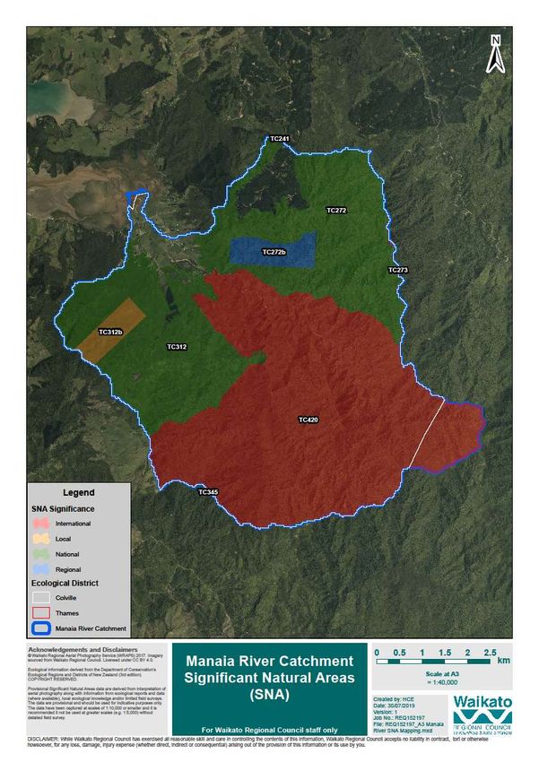
Table of Contents

1     Project background ......................................................................................................................... 4
2     Harbour and catchment planning and Manaia River ...................................................................... 4
3     Communication and engagement................................................................................................... 5
    3.1       Community engagement ........................................................................................................ 6
      3.1.1           Who did we involve? ....................................................................................................... 6
      3.1.2           What we heard................................................................................................................ 8
      3.1.3           Our commitment to the community............................................................................... 9
4     Scope and expectations ................................................................................................................ 10
5     Previous works .............................................................................................................................. 11
6     Manaia River action tables and map reference ............................................................................ 12
7     The Manaia River catchment ........................................................................................................ 18
    7.1       Introduction .......................................................................................................................... 18
8     He tangata – the people ............................................................................................................... 21
9     Physical attributes ......................................................................................................................... 22
    9.1       Geology ................................................................................................................................. 22
    9.2       Soils ....................................................................................................................................... 25
    9.3       Present land cover for Manaia catchment ........................................................................... 27
    9.4       Erosion potential of Manaia catchment ............................................................................... 29
    9.5       Land use capability ................................................................................................................ 31
10         Water quality ............................................................................................................................ 33
11         Ecological and biodiversity information ................................................................................... 37
    11.1      Significant natural area (SNA) ............................................................................................... 38
      11.1.1          Background information ............................................................................................... 38
      11.1.2          SNAs in the Manaia catchment ..................................................................................... 39
    11.2      Restoring native habitat biodiversity .................................................................................... 41
    11.3      Native vegetation and soil erosion ....................................................................................... 42
    11.4      Pest animals .......................................................................................................................... 42
    11.5      Pest plants ............................................................................................................................. 43
    11.6      Kauri protection – kauri dieback ........................................................................................... 44
12         Coastal habitat .......................................................................................................................... 45
    12.1      Mangrove communities ........................................................................................................ 47
    12.2      Immediate threats for the coastal marine area (CMA) – at Manaia .................................... 47
      12.2.1          Grazing .......................................................................................................................... 48
13         Stream erosion .......................................................................................................................... 48

Doc # 14690344                                                                                                                                       Page 2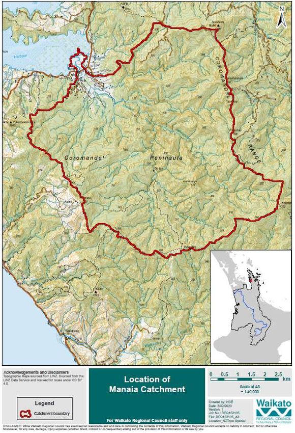
14       Climate change effects .............................................................................................................. 51
  14.1      NIWA study – Climate change resilience of a Māori community ......................................... 51
  14.2      Waikato Regional Council flood modelling 2009 .................................................................. 52
15       How regional council will support this work............................................................................. 54
  15.1      Fencing and planting ............................................................................................................. 54
  15.2      River management ................................................................................................................ 54
     15.2.1         Flood mitigation ............................................................................................................ 56
16       Funding ..................................................................................................................................... 56
  16.1      Funding options .................................................................................................................... 57
17       References/Bibliography........................................................................................................... 59
18       Appendices ................................................................................................................................ 60
  18.1      Appendix 1 – Manaia Draft Actions ...................................................................................... 61

Acknowledgements
The impetus for this plan arose from ongoing conversations with tangata whenua about the
preservation and enhancement of Manaia River and surrounding land. The Manaia community have
willingly given up their time, knowledge, and experience to engage with Waikato Regional Council in
the development of this plan. We have endeavoured to capture the aspirations of the community to
set the foundation for the Manaia River Restoration Plan.

We wish to acknowledge the support and contributions that have been made by Ngāti Pukenga, Ngaati
Whanaunga, Department of Conservation staff and the people of the Manaia.

The community within this catchment have helped us to prepare this document and their patience
and support is appreciated. It is their vision, aspirations and support which makes this work possible.

It is now our collective responsibility as community, tangata whenua and agencies to bring this
document to life and to seek to make a difference to the future of Manaia River and the catchment.

Doc # 14690344                                                                                                                                  Page 3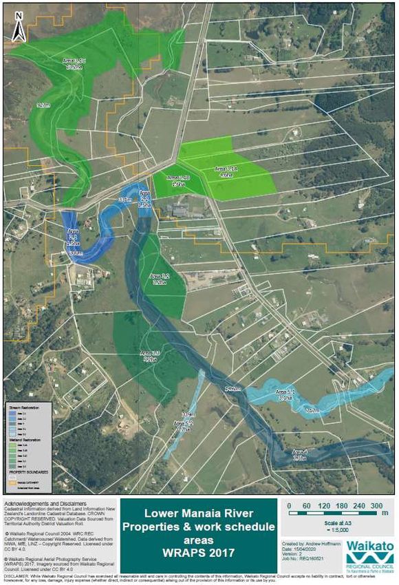
1         Project background
Ki uta ki tai – Coromandel/Manaia is split into two components: the full harbour and catchment
management plan and a restoration plan that focuses on Manaia River.

This document focuses on the latter, and the plan is a partnership between landowners and Waikato
Regional Council. The plan will enable Waikato Regional Council (the council) to expand on river
management works that have been carried out on Manaia River since the 2002 and 2008 weather
events. It also builds on the kōrero between the council and the community as to restoration
opportunities and how the community would like to see their awa in the future. This plan supports
the desire by the Manaia River community and individual landowners for a more comprehensive
restoration programme. It will become a deliverable of Ki Uta Ki Tai – Coromandel/Manaia Harbour
and Catchment Management Plan (HCMP), due to be completed this year.

Central to this work is the relationship with the Manaia community, the wider whanau of Ngāti
Pukenga ki Manaia, Ngaati Whanaunga, Ngāti Maru, individual landowners along the Manaia River
and Te Wharekura o Manaia. We engaged with landowners (approximately 20 properties in close
proximity to the river) to help us understand the current issues and concerns held by the Manaia River
community regarding river and catchment matters such as water quality, erosion, restoration, habitat
and flow during floods. Council field staff also walked along the Manaia River to collate ideas and
options for river and catchment works.

This plan seeks to address the community’s concerns, building on historical works and ensuring a well-
planned, coordinated approach. It also identifies funding sources to support prioritised works. All
projects will be a collaboration between the Manaia River Community, respective landowners, the
marae and/or kura and the council.

2 Harbour and catchment planning and
Manaia River
The Manaia River Restoration Plan sits as a deliverable of the Coromandel/Manaia HCMP. This is a key
tool in the delivery of work programmes for the Coromandel Zone.

Harbour and catchment management plans are a way for people to share what they would like their
natural environment to be like in the next 10 to 50 years. Environmental changes are raising people’s
awareness of the need for careful management of our natural resources into the future, along with
the need to meet economic, cultural, and social outcomes.

The Manaia River Restoration plan will build on the fantastic work already being carried out by tangata
whenua in the Manaia catchment. The plan is non-statutory, operational, and focuses on delivering
results. The plan will help determine where the Manaia community should focus their efforts in river
restoration, and where the council and other partners can give support.

“Be around for future generations” – an aspirational quote from a Manaia River hui attendee.

It is important to note this is a non-statutory exercise and will not pre-empt the co-governance plan
to be produced as a result of the Pare Hauraki Collective Treaty settlement, nor change any existing
consents that people hold.

Doc # 14690344                                                                                   Page 4
3         Communication and engagement
A key factor in the success of this project will be the continuing engagement with the Manaia
community, landowners, and partners, building on the kōrero from the Manaia River restoration hui
held in August 2019.

The people of Manaia have a willingness to openly share, dream and discuss the current issues and
potential for a thriving, vibrant, abundant Manaia river – both in terms of the native flora and fauna
and the revitalisation of the community for its people.

It was recognised, during plan development, that engaging early with mana whenua on matters is
critical as that provides extremely valuable and worthwhile insights with benefits for both parties.

We went back and checked in with the community with what we had heard and as the plan evolved.
Checking in will continue as the plan is progressed, through community korero, hui, newsletters, and
media articles.

                  Picture 1 Manaia River restoration hui, August 2019

Doc # 14690344                                                                                  Page 5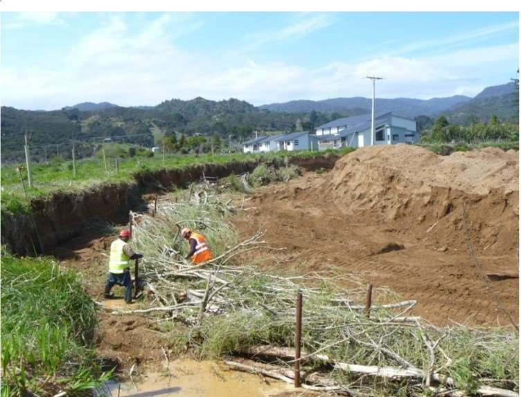
3.1       Community engagement
A community hui was held at Manaia Marae in August 2019 so the council and agencies could draft
the river restoration plan based on the community’s challenges with, and aspirations for, the Manaia
River and associated lands. The information gathered from the 30+ attendees at the Manaia Marae
formed the basis of the draft restoration plan. There were similarities to what the community voiced
14 years ago in their Manaia Community Plan prepared for Thames-Coromandel District Council. The
Manaia Community Plan, prepared in 2005/06, included the aspiration:
        • Protecting and strengthening Te Taiao
                 o By the year 2020 Manaia will be a thriving community of culturally enriched,
                     environmentally active, educated and politically astute people.
                 o The Manaia catchment will be the focus of nationally and international envy
                     because it will have a vibrant harbour and native forests, clean air, rivers and
                     stream, fertile and stable soil.

Many steps have already been taken towards this aspiration, and the delivery of this restoration plan
will go a long way to fully support the desired outcomes.

A second wananga at the marae was held in March 2020. Twenty people attended, and they
represented a cross section of the community. This group helped prioritise works, identify missing
issues and actions, and discuss the next steps of the draft restoration plan put before them. The
kōrero, was robust, positive, encouraging and focused on delivery. This wananga helped refine and
further develop the work programme, including actions and possible funding avenues. There was a
strong desire for works to start soon to leverage on the renewed enthusiasm and for works to be
bigger than business as usual with the ability to ‘layer’ up projects for multiple benefits.

Picture 2 Workshopping concepts and refining works programme, March 2020

3.1.1 Who did we involve?

The Manaia River community is arguably the largest Māori community residing collectively on the
Coromandel Peninsula. Those that whakapapa to the whenua include Ngāti Pukenga Ki Manaia, Ngaati
Whanaunga, Ngāti Maru and Ngāti Tamatera.

To realise a restoration plan for the Manaia River, it is important that the council supports the Manaia
River community to take leadership in the restoration of their river catchment, and understand that

Doc # 14690344                                                                                    Page 6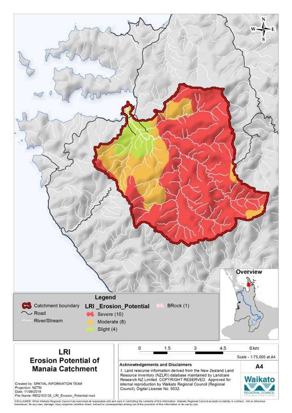
while properties are owned individually or collectively along the Manaia River, iwi Māori still live
largely by the philosophy that ‘we’ belong to the land.

The council worked with the Ngāti Pukenga chairperson and invited ratepayers and community
members residing along the Manaia River to attend the marae workshop to engage, collaborate and
provide an opportunity to share their knowledge, aspirations and concerns for the Manaia River and
adjacent lands.

We heard throughout the process that communities know their awa (river) best. To help achieve the
best outcome for the river, we wanted to hear what changes they have observed and experienced
over the years and to understand the connection between the people and the natural environment.

People said they had been connected to the river since the first waka arrived. Ko au ko te awa. Ko te
awa ko ahu (I am the river and the river is me).

Picture 3 The now familiar maps on the discussion tables during the Manaia River hui, March 2020

Doc # 14690344                                                                                     Page 7
3.1.2 What we heard
From our community engagement and feedback, we heard that there are a wide variety of issues and
they largely connect. We collated the information and the following five themes emerged:

 Theme                                     Description
 Improve water quality                     To restore the Manaia River to how it was 50+ years ago.

 Flood mitigation                          To undertake work to help mitigate flooding along the
                                           river and adjacent properties.
 Monitoring                                Establish monitoring to determine a baseline and measure
                                           water quality improvements/changes.
 Restoring biodiversity                    Identify the unique flora and fauna of Manaia; develop a
                                           restoration plan to ensure diversity and abundance of
                                           species for future generations.
 Community participation                   Explore opportunities (including in business) by
                                           establishing and growing community-led initiatives that
                                           embrace the local environment.

                                          Ko au ko te awa
                                         Ko te awa ko ahu
                                            I am the river
                                         And the river is me
It should be noted that one person, at the hui, asked for the removal of mangroves and one person
mentioned they did not want 1080 in the waterways. Kōrero with the community mirrored, to some
extent, the values we heard during engagement for other harbour and catchment plans for the
Coromandel Peninsula. It also highlighted the great work that is already being done and the strengths
of the community through collaboration and willingness to make a change for the environment. The
blend of two cultures and importance of mātauranga Māori and whānau connection to environment
can be seen in the following diagram.

                                      What would you like to see?
                 ‘Like the 1950’s – what we did with our Nanny’s – kai back in our awa’

Doc # 14690344                                                                                 Page 8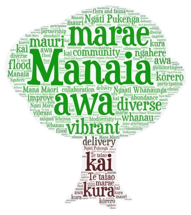
3.1.3 Our commitment to the community
The council is committed to:
    • working with the Manaia River community and landowners to help bring about change on the
       ground
    • building on our proven track record to deliver catchment management
    • working with other organisations to support efforts in the Manaia catchment, e.g. Predator
       Free Hauraki Coromandel Community Trust, the Ministry for the Environment, the Ministry
       for Primary Industries, the Department of Conservation, Thames-Coromandel District Council,
       Waka Kotahi/NZ Transport Agency and external funders as opportunities arise
    • coordinating works and services identified in this plan for Manaia.

Doc # 14690344                                                                              Page 9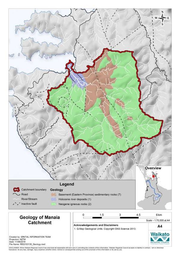
4 Scope and expectations
The Manaia River Restoration Plan is not about comprehensive flood control but about integrated
river management that may better protect property, reduce sediment in the river and harbour and
improve water quality. The plan includes pest reduction, improving plant and animal diversity and
sustaining the mauri of the river and surrounds, from the mountain ranges to the sea. It will promote
environmental best practice and help ensure economic, social, cultural, and environmental
sustainability. The plan will encourage partnerships between iwi, community and key agencies and
work towards a proactive community with a greater sense of environmental ownership. The
aspirations are the return of river species, being able to swim in the river, and ensuring an improved
environment for future generations.
Hui aspiration: the river will ‘be around for future generations.’
Picture 4 Intergeneration knowledge: Manaia River restoration hui, March 2020
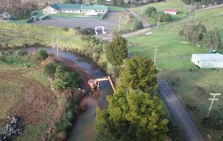
Doc # 14690344 Page 105 Previous works Table below shows the river management and river improvement works carried out by Waikato Regional Council from 2009 to 2019. On average, $20,000 per annum is spent on Manaia River (this does not include staff time for communication, engagement, catchment works or management staff). We recognise that many of the issues identified have a long historical link; therefore, we are focusing this restoration plan on actions we can do now which will make a difference to the environment in the next 10-50 years. Doc # 14690344
6 Manaia River action tables and map reference
The following table sets out key pieces of work to be considered and prioritised as shown in Map 1 (except for action 6/7) below. The information in the table has been refined from Appendix 1, the aspirations of the community as heard
at the hui. Not all the actions identified by the community in Appendix 1 fits the scope of this restoration plan, e.g. work that is outside the scope of the regional council.
Draft Manaia Action Table - post wananga
Length
Action Map ref Focus Goal Works area Actions Led by ha units Estimates Total
(m)
On farm field day with experts
to look at land use options,
capabilities, and alternatives i.e.
continuous cover forestry
Source a training provider to
train community in pole
Iwi want to make living in planting, chainsaw use,
Manaia more viable and spraying/weed control, native
To provide economic sustainable, to provide jobs planting and propagation,
opportunities through while improving the predator control. Training will
1 Training and development ensure ongoing work on projects $10,000.00
catchment restoration environment and
activities stimulating the local is sustainable
economy both socially and
economically
Investigate subject matter
experts on cottage industries,
i.e. native nursery, bees,
gardens, kai, weaving
Education and awareness raising
around managing waterway,
alternative land uses, soil
management
Plant, prep, maintain 600 1.5 2000 $4,000.00
2.1 Remediation: Bend above
Manaia SH bridge; work with Gravel extraction/management $6,600.00
landowners on a plan for pest Erosion control, rock/vegetation $25,000.00 $42,600.00
plant eradication and erosion armouring
To mitigate flooding protection $7,000.00
Infill with native planting
Erosion protection and through river maintenance
Stream edge is already fenced 2200
2 2.1, 2.2 restoration of Manaia River and management, 2.2 Corner bordering NZTA
from NZTA corner to bridge vegetation control and main road is remediated;
erosion protection Establish erosion protection/
protect corner from further
bank batter on eroded areas
erosion through channel $12,100.00
realignment, vegetation Bench 1 metre high, covered in
management, erosion control geotextile cloth
and infill native planting
Rock riprap
Doc # 14690344 Page 12Vegetation and erosion control
Stream channel realignment
Plant, prep, maintain $4,400.00
Plant coastal natives to protect $7,700.00
banks, includes maintenance for
3 years
Grow community education/ Identify and talk to community/ 440 3.2 12000 HCMP and
involvement in environmental landowners catchment new
work that stimulates the works labour
Design plan and project to micro hours
economy, grows jobs, and has
level
the potential to grow local
contract businesses and Identify and secure external
cottage industry funding sources
Talk with community/kura to
gauge appetite and identify
champions to drive project, with
outcome of forming working
group
$85,280.00
Scope plan with resource
requirements outlined and
identified funding sources
3.2 Oxbow area fenced and
developed Resource consenting costs – $12,000.00
Work with interested expertise/resource consent for
landowners to develop design of constructed wetlands
marginal land left fallow or Wetland construction; materials $2,000.00
presently grazed to create and machinery
Wetland recreation for cottage industry and/or a
3.1, 3.2, Fencing $5,280.00
3 environmental/social/ wetland area for harakeke,
3.3
economic development tuna habitat, native Planting $42,000.00
garden; restore and Plant, prep, maintain $24,000.00
enhance native flora and
3586 19.4 1600 $12,000.00
fauna, though the delivery Resource consenting costs –
of constructed wetlands expertise/resource consent for
design of constructed wetlands
3.1 Identify landowners (3.1A Wetland construction; materials $10,000.00
and 3.1.B) from Goldfield and machinery
Rd/SH junction as well as Boardwalk and interpretative $150,000.00
downstream to coastal signage
environ (3.1C); if agreeable,
Plant, prep, maintain $32,000.00
develop a restoration plan $386,032.00
focus around constructed Site/weed maintenance $114,800.00
wetlands, including expertise, programme
administration resource costs Fence river edge below bridge $11,232.00
and operational work
programme Establish erosion protection/
bank batter on eroded areas
Plant coastal natives to protect $56,000.00
banks; includes maintenance for
3 years
Check out if fenced 680 5.2 20000 HCMP $135,160.00
Doc # 14690344 Page 13Identify landowner and see if
they would like to develop
wetland
Plan with landowner work
programme
3.3. Potential wetland area $12,000.00
Resource consenting costs –
that connects to Manaia River
expertise/resource consent for
main channel; on true left of
design of constructed wetlands
river, mid-section
Wetland construction; materials $5,000.00
and machinery
Fencing $8,160.00
Planting $70,000.00
Plant, prep, maintain $40,000.00
Weed control $5,000.00
Blockage removal $5,000.00
Gravel management $11,000.00
Clear channel as required and Riparian fencing along areas not $22,000.00
Manaia main channel
fence to minimum 10m of fenced
needs clearing and planting $109,000.00
riverbank, plant willows, infill
to avoid erosion Step back existing fencing that is $12,000.00
native and plants
too close to river
Erosion control – channel $54,000.00
training, vege groyne, willow
planting
Channel maintenance and
4 4 Blockage removal $4,950.00
enhancement
Gravel management $4,950.00
To have riverbanks to bush Weed control along main TBC
line planted in native plants channel and tributaries – kikuyu,
Upper river channel is and channel managed to woolly nightshade, black berry,
maintained and erosion prevent erosion during high moth plant $23,900.00
protection in place rainfall to support a reduction Willow pole planting $3,000.00
in sedimentation and TBC
Possible native tree planting
improvement in water quality
$11,000
Erosion control ($2750.00 per
day)
Stream fenced, taking high 1432 19600 $11,456.00
ground variance from 5-15m
minimum planted margin
5.1 Fence Tupa Stream to give $9,000.00
Tupa steam fenced in its
a corridor of native habitat Erosion control, possible
entirety (approx. 1000 $57,856.00
and keep stock out to assist in channel training, vege groyne
metres)
Tributaries fenced and improving water quality
5 5.1, 5.2 Plant, prep, maintain $11,200.00
planted
Willow pole planting $6,600.00
Possible native tree planting $19,600.00
Fence, plant with natives and n/a n/a n/a $9,000.00
Ensure all tributaries to Fence all unfenced stream edges
plan 3-year maintenance
Manaia River are fenced $51,500.00
programme for all tributaries $35,000.00
and planted Native planting
that supports a reduction in
Doc # 14690344 Page 14sedimentation and an $7,500.00
Maintenance
improvement in water quality
Fencing 678 36553 2680 $5,424.00
5.2 Have stock excluded and
Planting $9,380.00
remedial work completed to
Waharaparapa Stream Plant, prep, maintain $5,360.00
manage erosion, and
fenced and planted, and $43,164.00
permanent water reticulation Culvert across stream for stock $15,000.00
stream mouth restored
to remove the need for cattle and transport
access to stream
Water reticulation $8,000.00
Potential for extensive $200,000
predator control for the (Discussion
Predator control – mixed figure)
purpose of biodiversity
methods, picking up existing $180,000.00
enhancement; deliver whanau
A coordinated approach to trap network. Discussion figure
Improved biodiversity desire to protect/enhance
plant and pest control
6 through biosecurity ngahere and manu
along the awa and up into
measures $50,000
ngahere (forest) Kauri protection measures Given the significance of the
(arbitrary)
taken; education/awareness Manaia Kauri Sanctuary, ideally
$50,000.00
raised and available across kauri protection would be at the
community upper end/gold standard
Establish programme to work WRC labour
with community to monitor
water quality
Build on stream mouth
Potential to establish Work with community/school to
monitoring programme and
guidelines/measuring of establish a fish survey
7 Water quality monitoring faecal contaminant/source $130,000.00
water quality/biodiversity programme; monitor river
tracking work from 2015 as
of catchment species numbers in awa
baseline
Processing samples Lab fees
10-year programme to monitor
change
Total (Est) $1,316,592.00
Doc # 14690344 Page 15Map 1. Works locations Manaia River Doc # 14690344 Page 16
Site Length (m) ha Works overview
2.1 600 1.5 River management – erosion protection
2.2 River channel planning, erosion protection, native planting
3.1a 936 4.6 Constructed wetland
3.1b 550 1.6 Constructed wetland
Riparian planting and wetland recreation, including board
3.1c 2100 13.2
walk
3.2 440 3.2 Wetland/oxbow
3.3 680 5.2 Wetland retirement
4 2984 Fence and plant to give corridor of native habitat
Stream fenced: taking high ground variance from 5-15m
5.1 1432
minimum planted margin
5.2 678 Stream fenced and planted
Picture 5 Where would you begin the mahi?
Manaia River restoration hui, March 2020
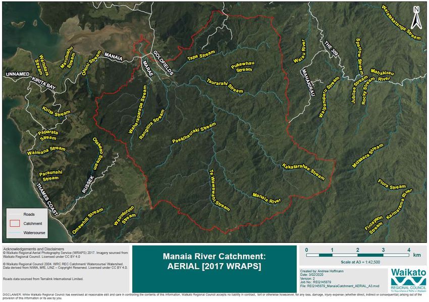
Doc # 14690344 Page 177 The Manaia River catchment 7.1 Introduction On the Coromandel Peninsula’s west coast, just south of Coromandel town, there is a settlement which is known to some as the centre of the universe, Manaia. Chances are you will have driven through Manaia as you head north. This mahi is all about Manaia (and particularly the river, wetlands and flood plain), appropriately named as the mythical creature Manaia is usually depicted as having the head of a bird and the tail of fish, and this restoration plan includes from the mountain to the sea. This plan for mahi focuses on the Manaia River channel, two main tributaries (the Tupa and Waharaparapa streams) and the properties adjacent to them and other waterways below the bush line. Plans for the wider Manaia catchment will be included in the Ki Uta ki Tai – Coromandel/Manaia HCMP. The Manaia River flows north from its sources in the Coromandel Range to reach Tīkapa Moana (the Hauraki Gulf) at Manaia Harbour, 10 kilometres southwest of Coromandel township. There are large areas of indigenous vegetation in the middle and upper Manaia catchment, which is nationally and internationally significant for biodiversity. However, the catchment has about 3 kilometres of river channel in pasture. The total river length is 12km and it weaves through approximately 20 properties. There is a marae and school in the catchment and the community is actively working with the council on river management. Doc # 14690344 Page 18
Map 2. Manaia River catchment
Doc # 14690344                  Page 19
Map 3. Topographic map Manaia River

Doc # 14690344                        Page 20
8         He tangata – the people
Manaia is arguably the largest Māori community on the peninsula north of Thames. The people are
predominantly of Ngāti Pūkenga ki Manaia, Ngaati Whanaunga and Ngāti Maru. The ancestral meeting
house at Manaia is named after Ngāti Pukenga paramount chief Te Kouorehua and the whare manaaki
is Ngairihanga.

Manaia, 10km south of Coromandel town, was gifted by Ngāti Maru to Ngāti Pukenga in recognition
of Te Kouorehua’s assistance during the musket wars. Ngāti Maru iwi also reside at Manaia, and
together with Ngāti Pukenga and Ngaati Whanaunga, have tribal authority at Manaia. This is one of
the few large Māori-owned areas in Hauraki.

The Manaia River (Te Awa o Manaia) is the ancestral river of the Manaia people. This means the
relationship between the people and the awa is inseparable; without one, the other is lost.

Picture 6 Manaia River and towards the kura; looking down stream

Ko Manaia, he pataka kai’ (Manaia the food store)
Manaia was well known for its rich abundance of food within the catchment: in the river, estuary, and
sea. Fishing and mussel farming employ locals, however, as they are for most other estuarine harbours
on the peninsula siltation, nutrient inputs and mangrove expansion are a concern for the harbour.

Doc # 14690344                                                                                Page 21
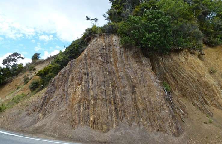
9         Physical attributes

Picture 7 Manaia River upstream, as it leaves the ngahere (bush) and enters the pasture

9.1       Geology
Like much of the main Coromandel Range, the Manaia catchment is underlain with a base rock of
greywacke formed some 150 million years ago during the Cretaceous period (see Chart 1 below).
Greywacke is a common New Zealand sandstone that makes up the basement rock of the main ranges
of the North Island, and it is found from Manaia to the top of the Coromandel Peninsula. This base has
more recently been covered with volcanic rock (Malengreau et al. 2000).

The basement rock, collectively known as the Manaia Hill Group, can be seen in a road cutting on State
Highway 25: vertical bands of greywacke and argillite formed in the late Jurassic to early Cretaceous
period (160-110 million years ago).

Doc # 14690344                                                                                 Page 22
Picture 8 The SH25 road cutting showing banded greywake and argillite known as the Manaia Hill group.
   The formation has been tilted over time to a vertical position

The Miocene epoch was when widespread andesite volcanoes were present around the Colville-
Manaia area, and the volcanic rocks are known as the Coromandel Group. Mount Ruapehu is a
present-day example of an andesite volcano with typical andesitic ash and lava deposits.

These ancient volcanic landforms have been deeply eroded over millions of years, creating the steep
and heavily incised landscape we see today. Volcanic tephra (airborne material ejected, such as ash)
has become weathered over geological time, contributing to the formation of the area’s volcanic
brown soils.

When the last ice age ended about 10,000 years ago, the warmer climate of the Holocene epoch
produced the most recent geology. Manaia and Coromandel harbours formed when sea levels rose
over 100 metres, drowning river valleys.

Recent geology consists of unconsolidated deposits that dominate the valley floors, stream mouths
and foreshores. These are the sands, silts and gravels that are typical of an active cycle of erosion,
deposition, and reworking of materials from the older landforms.

Chart 1. Geological timescales
 Geological       Million years ago (mya)       Geological epoch       Manaia
 Period
 Quaternary       Recent to 2.58 mya            Holocene epoch         Recent – 10 000 ya
 Neogene          2.58 to 23 mya                Miocene epoch          5.33mya – 23 mya
 Paleogene         23 to 66 mya

 Cretaceous        66 -145 mya
 Jurassic          145-200 mya

Doc # 14690344                                                                                    Page 23
Map 4. Geology of Manaia catchment
(The geology map shows the broad geological types with reference to their geological age.)

Doc # 14690344                                                                               Page 24
9.2       Soils
Soil type                   Sub area (ha) Catchment %
Brown                       4613             96.2
Recent                      180.6            3.8
Total                       4793.6           100

The Manaia catchment is dominated by brown soils (96.2 per cent) which are volcanic in origin (mostly
andesite in this catchment) and have weathered from parent volcanic material or greywacke. The
brown colouring is from iron oxides. These soils are typical in areas where total summer dryness is
uncommon (rainfall exceeds 1000mm per year). They do not become waterlogged in winter as they
are generally well-drained and have moderate amounts of organic matter. The brown soils in this
catchment are found on the Manaia slopes.

Recent soils (3.8 per cent) are the soils formed on recent land surfaces such as the silts and gravel of
alluvial flood plains or the sandy soil typical of coastal environments. These soils are relatively young,
formed usually within the last 2000 years, and are generally free draining.

Doc # 14690344                                                                                     Page 25
Map 5. Soil orders for Manaia catchment

Doc # 14690344                            Page 26
9.3       Present land cover for Manaia catchment

Name of cover (as of 2012)               Sub area (ha) Catchment %
Broadleaved indigenous hardwoods 83.4                    1.7
Built-up area (settlement)               10.6            0.2
Deciduous hardwoods                      8.3             0.2
Estuarine open water                     0.3             0
Exotic forest                            14.2            0.3
Forest - harvested                       140             2.9
Herbaceous saline vegetation             8.7             0.2
High producing exotic grassland          130.7           2.7
Indigenous forest                        3479.9          72.6
Low producing grassland                  3.8             0.1
Mānuka and/or kānuka                     912.6           19
River                                    2.8             0.1
Total                                    4795.3          100

The main catchment cover is indigenous forest at 72.6 per cent with mānuka/kānuka scrub being the
second most common cover. Grasslands only cover at 2.8 per cent. Forestry in the upper catchment
is 3.2 per cent overall.

Land cover can influence the intensity of erosion, flooding, and sedimentation. In general, an intact
vegetation cover, particularly in the steeper areas of a catchment, will reduce the intensity of these
naturally occurring processes.

As recorded in historic accounts of the catchment, the rapid removal of the original forest during
activities such as kauri logging or clearing land by fire for farming has produced an intense period of
erosion and sedimentation due to the loss of protective vegetation. Today, regenerating scrub,
appropriate land management of pastoral or forestry activities and formal protection of indigenous
forests have helped mitigate the historic sudden changes in land cover and the subsequent
downstream effects such as sedimentation.

Doc # 14690344                                                                                  Page 27
Map 6. Manaia catchment land cover

Doc # 14690344                       Page 28
9.4       Erosion potential of Manaia catchment

Erosion potential description Sub area (ha) Catchment %
BRock (base rock)                9.6             0.2
Moderate                         1014.2          21.1
Severe                           3400.4          70.9
Slight                           371.1           7.7
Total                            4795.3          99.9

Erosion is an important natural and continuous process. Even under forest cover, erosion such as soil
slips still occur. Slope and erosion rates are important limiting factors for land use and, through
mapping erosion potential, a catchment’s advantages and limitations can be assessed.

The issue of managing land to lessen the impact of erosion, or to avoid exacerbating it through
activities such as farming or clear-felling steep slopes, has led to the land use capability (LUC)
classification system.

Seventy per cent of the Manaia catchment has severe erosion potential. When overlaying this with
the land cover map (Map 6), the areas of severe erosion potential are also areas with indigenous forest
and mānuka/kānuka cover. This is the ideal cover for a short, steep catchment such as Manaia. The
most vulnerable land is protected by well-established mature ngahere (bush) or regenerating scrub.

Doc # 14690344                                                                                  Page 29
Map 7. Erosion potential of Manaia catchment

Doc # 14690344                                 Page 30
9.5       Land use capability
By considering erosion type, vegetation cover, soil type and terrain (slope and topography), etc., we
can determine the land use capability. LUC determines how versatile land can be for cultivation and
productive activities such as agriculture or horticulture.

          Sub
LUC               Catchment
          area
class             %
          (ha)
                                Class 2 indicates high performance sheep and beef production on
                                alluvial flats is possible. In the Manaia catchment, this is limited by soil
2s      161.8     3.4
                                type (2s). The soils are partially limited by their relative youth and
                                therefore a lack of a mature, deep soil profile.
                                The 24.7% that is Class 6 land is a mixture of pastoral farming, exotic
6e      1182.4    24.7
                                forest (pines) or scrub.
7e      3441.5    71.8          Land that is Class 7e or 7w is unsuitable for production purposes and
                                should be retired from such activities.
7w      9.6       0.2

Total 4795.3      100.1

In the above table, e is for erosion, s is for soil and w is for wetness.

There are 8 LUC classes which signify land versatility and arability, with Class 1 being the most versatile
and 8 having severe limitations.

 e      Signifies the main limitation to diversity of land use and cultivation is soil erosion risk. Both
        steep land and flat land can be limited by a high erosion risk. For example, 8e is assigned to
        both extremely steep hill country and land such as sand spits or back dunes. Even though
        sand spits may be flat land, wind erosion of the sandy soils may severely impact on that land’s
        uses.
 s      Signifies the main limitation to diversity of land use and cultivation is soil type.
 w      Signifies the main limitation to diversity of land use and cultivation is wetness of the soils.

Manaia is a catchment dominated by steep hills and stream gullies which limits the versatility of the
land for production purposes in the upper catchments.

At present, what was considered marginal productive pastoral land on the Coromandel is now being
considered productive for new commercial ventures based around the mānuka honey industry. This
is an ideal land use as establishing vegetation is an appropriate land cover for such erosion prone
terrain.

To learn more about the LUC of land refer:
http://www.landcareresearch.co.nz/__data/assets/pdf_file/0017/50048/luc_handbook.pdf

Doc # 14690344                                                                                       Page 31
Map 8. Land use capability of Manaia catchment Doc # 14690344 Page 32
10 Water quality
Many small stream mouths in the Coromandel flow to beaches. These stream mouths support a wide
range of aquatic life and are often popular swimming locations. The water at these locations can be
susceptible to contaminants washed from the catchment because the mixing of fresh water with
seawater is often limited. Furthermore, some of the stream mouths become blocked regularly
because of natural coastal processes.

During January and February 2015, Waikato Regional Council sampled the water quality of 18 of these
stream mouths in the Coromandel area, including two in the Coromandel/Manaia catchment (Figure
1): of the Whangarahi Stream and Manaia River.

The purpose of this investigation was to provide a one-off snapshot of coastal stream mouth water
quality in the Coromandel area and to trial a new approach to investigate potential sources of faecal
bacteria such as humans, possums, dogs, pigs, gulls and ruminant animals, more specifically cows
(Wilson, 2016).

This work could be used as a benchmark for future monitoring programmes.

The sampling programme was designed to investigate two aspects regarding water quality:
    1. the ecological health of the system, and
    2. the concentration and potential sources of faecal bacteria that, at high levels, can indicate a
       human health risk.

It is important to note, however, that the report on the results of the survey does not make specific
comments on public health, such as whether a location is deemed safe to swim or not, as this is out
of scope and outside of council’s jurisdiction.

Results of the investigation of ecological health are shown in Figure 2. To assess results for ecological
health, water quality parameters were compared to Australian and New Zealand Guidelines for Fresh
and Marine Water Quality (ANZECC & ARMCANZ, 2000), commonly referred to as the ANZECC
guidelines.1 The ANZECC guidelines provide very conservative guideline values, and exceeding one of
these values does not imply that there are any adverse ecological effects. Instead, this indicates that
further investigation should occur to determine the cause of the exceedance and to determine
whether there are any adverse ecological effects.

Results of the investigation looking at the suitability of the coastal stream mouth sites for contact
recreation are shown in Figure 3. To assess water quality for contact recreation, results were
compared to guideline values for parameters relating to contact recreation (MfE & MoH, 2003),
commonly referred to as the recreational water quality guidelines.

The key findings for all sites were (Wilson, 2016)2:
    • These water types are particularly susceptible to contaminants (excess nutrients and faecal
        contaminants) that are washed from the surrounding land, particularly 24-48 hours after
        heavy rainfall.

1
    There were no New Zealand specific guidelines for estuarine water quality at the time of writing this report. The ANZECC guidelines
       recommend that values for south-east Australia be used in the absence of more appropriate regional or national guideline values in
       New Zealand.
2    Also described in a summary of the technical report available at www.waikatoregion.govt.nz/services/publications/technical-
       reports/2016/tr201607/

Doc # 14690344                                                                                                                  Page 33
• The water clarity was good (low turbidity) and dissolved oxygen concentration was typically
high at most sites.
• Median nutrient concentrations were within the guideline values at most sites. This means
that at most sites, nutrient concentrations were within the guideline values at least half the
time. The reason for these exceedances is more complex than just heavy rainfall.
• Most sites were within the recreational water quality guideline value most of the time.
However, most sites exceeded the guideline value following heavy rainfall in the area. Some
sites also exceeded guideline values during spring tides.
• Faecal source tracking was useful to identify possible sources of faecal bacteria in the water;
however, it could not determine exactly how much each source contributed overall.
• Ruminant animals were one of the most common sources of faecal contamination. Possum
and gull sources were also seen at most locations.
• Human sources were only detected at a few sites and only on few occasions following heavy
rainfall or high spring tides.
The above findings apply to the Manaia site. In addition, a particularly noteworthy conclusions drawn
in Wilson (2016) was:
• During the two sampling months, the ecological health of the Manaia River was very high.
Faecal bacteria exceeded guideline values on only two occasions. On one of these occasions,
exceedance followed heavy rainfall. This is typical in these water types and why Thames-
Coromandel District Council, Waikato District Health Board and the council advise people not
to swim after heavy rainfall.
Doc # 14690344 Page 34Figure 1. Locations of water quality sampling sites surveyed in 2015. Located in the Coromandel/Manaia
catchment are Whangarahi Stream and Manaia River. The size and land use of each stream’s
catchment is indicated by the coloured shading. NZTM coordinates are indicated on the
surrounding frame. Source: Wilson (2016).
Doc # 14690344 Page 35Figure 2. Summary of results used to assess the ecological health of the coastal stream mouth sites. Sites
in the Coromandel/Manaia catchment are those in the purple box. Results shown in blue are
within the ANZECC water quality guidelines. Results shown in orange exceed the guidelines.
Source: Wilson (2016).
Doc # 14690344 Page 36Figure 3. Summary of the faecal bacteria results used to assess the suitability of the water for contact
recreation. The circles show the per cent of samples that were within the guidelines (blue
proportion) and those that exceeded the recreational water quality guidelines (orange). Source:
Wilson (2016).
11 Ecological and biodiversity information
The Coromandel Ecological Region has nine ecological districts and stretches from Aotea/Great Barrier
Island to Te Hunga Ridge in the Kaimai Range.
The Colville Ecological District (ED) is the second most northern district. It encompasses the Moehau
Range and Cuvier Island. Its southern boundaries are north of Whitianga on the eastern side and Te
Mata on the western side.
The maunga Kakatarahae (725m above sea level) is within the Thames Ecological District though the
Kakatarahae Stream flows westward in the Manaia catchment and therefore sits in the Colville ED.
Two distinctive features of the Colville ED are the exposure of relatively large blocks of greywacke and
common occurrence of taraire (Beilschmiedia tarairi) trees.
The Colville ED has not suffered the same amount of clearance as other ecological districts
in the Waikato region. With a relatively large amount of scrub, regenerating forest and
(albeit heavily logged) forest remnants, the ED is remarkable for its diversity of
high quality wildlife habitat and is in a zone characterised by high levels of regional endemism for
woody plant species.
Doc # 14690344 Page 37Ecological habitats found within the Colville Ecological District are montane forest, coastal forest, lowland forest, and wetlands, including saltwater marshlands. Threatened or naturally uncommon plant species such as Pittosporum virgatum are also present. Species of fauna, that either no longer exist, are rare/threatened, or have fragmented populations in other parts of New Zealand, can be found in the Colville ED. North Island brown kiwi, pāteke (brown teal), kākā, mohopererū (banded rail), matuku-hūrepo (Australasian bittern) and mātātā (fernbird) populations are present within the Colville ED. Extremely rare reptiles such as striped gecko (toropuku Coromandel) and pepeketua (Archey’s and Hochstetter’s frogs) are also present in fragmented populations. Significant Natural Areas of the Thames-Coromandel District: Terrestrial and Wetland Ecosystems Environment Waikato Technical Report 2010/36 https://www.waikatoregion.govt.nz/assets/PageFiles/20481/TR%202010-36.pdf 9 Pāteke swimming in Colville Ecological District (ED) Pāteke are now a regular sight across the Colville ED. They were introduced back onto the northern tip of the peninsula in 2002. They have since spread around the Coromandel Peninsula from this original release site thanks to continuing predator control. 11.1 Significant natural area (SNA) 11.1.1 Background information The council identifies significant natural areas (SNA) as areas that meet one or more criteria for significance in the Waikato Regional Policy Statement. Identification of SNA is an important step in managing the region’s natural heritage, protecting threatened species from the risk of extinction, reconnecting fragmented ecosystems, and meeting Doc # 14690344 Page 38
the requirements of the Resource Management Act 1991. Significant natural areas provide us with a
wide range of ecosystem services, including habitat for native plant and animal species, flood, or
erosion control, providing oxygen and helping to regulate climate and scenic appeal.

SNA mapping helps to identify significant habitat or populations of indigenous fauna and flora which
allow us to consider what management tools are needed to maintain or improve these populations.

11.1.2 SNAs in the Manaia catchment
 SNA Name                          Type                                               Significance
 TC272b - Coromandel Forest        Lowland broadleaf/podocarp forest                  Regional
 Park Outlier 1
 TC420 - Coromandel Forest         Lowland to montane forest and scrubland            International
 Park
 TC272 - Tawhitirahi Area          Semi-coastal, lowland secondary broadleaf National
                                   forest and scrubland
 TC312 - Pukewhakataratara         Lowland broadleaf/podocarp forest and National
 Forest                            coastal broad/small leaved scrubland
 TC312b - Manaia Block             Lowland kauri conifer-broadleaf forest    Local
 Stewartship Land
 TC273 - Mahakirau (borders        Rata/podocarp/tawa forest                          International
 Manaia catchment)

Council and other organisations encourage landowners to retire and restore significant areas of
biodiversity, and have various funding grants available that landowners can apply for.

The Significant Natural Areas of the Thames-Coromandel District: Terrestrial and Wetland
Ecosystems Environment Waikato Technical Report 2010/36, which includes Colville ecological
district, can be found here:
https://www.waikatoregion.govt.nz/assets/PageFiles/20481/TR%202010-36.pdf.

The Manaia River catchments were identified as being in the highest scoring 20 per cent of river
catchments in a SNA identification type exercise, with some being identified as a top priority for
protection.

The data in the technical report is derived from analysis and interpretation of aerial photography along
with information from ecological reports and data (where available), local ecological knowledge and
limited field surveys.

Doc # 14690344                                                                                   Page 39
Map 9. Manaia River catchment significant natural areas Doc # 14690344 Page 40
11.2 Restoring native habitat biodiversity
To improve habitat biodiversity in catchments, the council and other organisations help landowners
and communities invest in the planting of native species that are suitable for the ecological area.

By restoring the native plant cover we:
    • create corridors and linkages between SNAs and/or habitat types – this may be connectivity
        between large fragmented habitats such as coastal forest areas or small scale such as a stream
        with a wetland in proximity but no native vegetation linking the two
    • restore species that may have been present in the past but are now absent for various reasons,
        e.g. northern rata, which is susceptible to possum browsing, may have died out from an area
        of bush
    • create more diverse habitat by providing different available food sources year-round for
        insects, lizards, and birds
    • create and/or preserve carbon sinks; intensive pest animal browsing diminishes the potential
        carbon sink of existing native vegetation.

The guide to what is appropriate in the Colville Ecological District is found in the ‘What to Plant in
Coromandel Ecological Region’ publication available online.

https://www.waikatoregion.govt.nz/Environment/Natural-resources/Biodiversity/Planting-
guides/What-to-plant-in-the-Coromandel-ecological-region/

Native plant nurseries established by local communities are becoming a key focus for implementation
of the community’s aspirations, such as a healthier awa and catchment. There are numerous funding
agencies to help communities establish native plantings. Funding can be raised through grants or
crowd funding schemes such as:
     • Million Metres Streams Project
        https://millionmetres.org.nz/
     • Te Uru Rakau One Billion Trees Programme
         https://www.teururakau.govt.nz/funding-and-programmes/forestry/one-billion-trees-
         programme/

Picture 10 Manaia wants planting days with tamariki, like this day with
students from Te Rerenga School

Doc # 14690344                                                                                 Page 41
11.3 Native vegetation and soil erosion By protecting and/or restoring native vegetation, like in SNAs or native scrub blocks, landowners help to address soil erosion and sedimentation issues within a catchment. Erosion and sediment deposition are natural cycles as landscapes change over time. The issue for Aotearoa/New Zealand is that the significant and widespread removal of vegetation cover in a short period of time has seen an acceleration in the rate of erosion. This in turn has seen many harbours and estuaries infill with sediment and left hill country scarred with soil slips, etc. These areas can become vulnerable to further large-scale erosion, particularly during intense storm events. Even where vegetation cover and bush canopy are present, the lack of understorey in many bush blocks, due to browsing of foliage and seeds by introduced mammals such as possum, goats, pigs and rats, leads to an increase in surface water runoff and soil erosion. A healthy understorey beneath the bush canopy allows for better water uptake, better filtration of sediment and increases resilience in extreme weather events. Pest control, therefore, is a crucial part to maintaining a healthy bush block as it allows the understorey to persist. Recruitment of species (e.g. seedlings) is also enhanced when plants can establish without browsing pressure. Fencing off existing vegetation from browsing stock also addresses the above issues. Picture 11 A lack of understorey (left) decreases the land's ability to absorb and filtrate both water and soil runoff whereas an intact understorey (right) aids filtration 11.4 Pest animals Introduced animals that have readily naturalised in New Zealand (often in the absence of their natural predators from their land of origin) have had a significant impact on indigenous fauna and flora. The introduction of mustelids (e.g. stoats) brush tail possums, rats, cats, hedgehogs, feral pigs, and goats have all impacted on Coromandel’s native biodiversity. Uncontrolled dogs are a threat to adult Coromandel brown kiwi. Mammalian predators reduce the likelihood of successful breeding seasons for our native birds by preying on eggs and chicks. If adult birds are sitting on nests, they are vulnerable to attacks as well which leads to a decline in adult female birds within a population. Doc # 14690344 Page 42
There are many community groups and individuals within the Colville ED addressing this issue by
servicing a wide network of trap lines for pest animal species. Communities are also doing restoration
works such as planting native trees and carrying out citizen science, e.g. monitoring, to help protect
and increase our indigenous species populations.

11.5 Pest plants

Picture 12 Woolly nightshade in the Pine Plantation behind Manaia

Invasive pest plants are a significant threat to the decreasing and fragmented native
ecosystems/habitats within the Manaia catchment. Many of these habitats are already under pressure
from disturbances both historic and current. Pest plants can colonise vulnerable areas, further
reducing native vegetation, and may become ecosystem transformers. For example, large wild ginger
infestations make it impossible for kiwi to probe the soil for food due to the large, impenetrable root
systems of this plant.

The importance of controlling pest plants as bird numbers increase due to successful predator control
is crucial. Birds can spread seeds of plant pests such as climbing asparagus and wild ginger, which are
ecosystem transformers.

Doc # 14690344                                                                                  Page 43
Key pest plants identified in the Manaia catchment
 Moth plant                                  Araujia hortorum (formally A. sericifera)
 Pampas grass                                Cortaderia selloana and Cortaderia jubata (purple
                                             pampas) The web link below shows the difference
                                             between native toetoe and the two invasive pampas
                                             species.
                                             https://www.waikatoregion.govt.nz/services/regional-
                                             services/plant-and-animal-pests/plant-pests/pampas/

 Saltwater paspalum                           Paspalum vaginatum
 Wild ginger                                  Hedychium gardnerianum and H flavescens
 Woolly nightshade                            Solanum mauritianum

For more detail about these pest plants see; https://www.waikatoregion.govt.nz/services/regional-
services/plant-and-animal-pests/plant-pests/

Invasive willow species are also present in wetland areas. These are not the sterile hybrids used for
soil conservation/streamside stabilisation.

11.6 Kauri protection – kauri dieback
Kauri are susceptible to a killer disease caused by the microscopic organism Phytophthora agathidicida
(kauri dieback). Kauri dieback is found across parts of kauri lands including in the Waitakere Ranges,
Waipoua, Great Barrier Island and on the Coromandel Peninsula at Whangapoua, Hukarahi
(Whitianga) and Tairua. Scientists are working hard to find control tools for the disease, but there is
currently no known treatment and once a tree is infected it will not survive.

The disease may be spread through as little as a pin prick of soil, therefore reducing soil movement in
and near kauri on properties is the best defense. Soil movement can be reduced by:
    • fencing out stock
    • controlling pests such as pigs and goats
    • ensuring anyone heading into native forest has cleaned all gear thoroughly as well as their
        dogs
    • ensure machinery coming onto or leaving a property is dirt free.

For more information on kauri dieback visit www.waikatoregion.govt.nz/kauri

Doc # 14690344                                                                                  Page 44
You can also read