Koyna, India, An Ideal Site for Near Field Earthquake Observations# - Proceedings of the Indian ...
←
→
Page content transcription
If your browser does not render page correctly, please read the page content below
Proc Indian Natn Sci Acad 85 No. 2 June 2019 pp. 469-480
Printed in India. DOI: 10.1007/S12594-017-0771-2 (Original)
Review Article
Koyna, India, An Ideal Site for Near Field Earthquake Observations #
HARSH K GUPTA1,*
CSIR-National Geophysical Research Institute, Hyderabad 500 007, India
The Koyna earthquake of M 6.3 on December 10, 1967 is the largest artificial water reservoir triggered earthquake globally.
It claimed ~ 200 human lives and devastated the Koyna township. Before the impoundment of the Shivajisagar Lake created
by the Koyna Dam, there were no earthquakes reported from the region. Initially a few stations were operated in the region
by the Central Water and Power Research Station (CWPRS). The seismic station network grew with time and currently the
National Geophysical Research Institute (NGRI), Hyderabad is operating 23 broadband seismographs and 6 bore hole
seismic stations. Another reservoir, Warna, was created in 1985, which provided a further impetus to Reservoir Triggered
Seismicity (RTS). Every year following the Monsoon, water levels rise in the two reservoirs and there is an immediate
increase in triggered earthquakes in the vicinity of Koyna-Warna reservoirs in the months of August-September. Peak RTS
is observed in September and later during December. Another spurt in triggered earthquakes is observed during the draining
of the reservoirs in the months of April-May. A comparative study of RTS earthquake sequences and the ones occurring in
nearby regions made it possible to identify four common characteristics of RTS sequences that discriminate them from
normal earthquake sequences. As the RTS events continue to occur at Koyna in a large number in a limited area of 20 km x
30 km, at shallow depths (mostly 2 to 9 km), the region being accessible for all possible observations and there being no
other source of earthquakes within 100 km of Koyna Dam, it was suggested to be an ideal site for near field observations
of earthquakes. This suggestion was discussed by the global community at an ICDP sponsored workshop held at Hyderabad
and Koyna in 2011. There was a unanimous agreement about the suitability of the site for deep scientific drilling; however,
a few additional observations/ experiments were suggested. These were carried out in the following three years and another
ICDP workshop was held in 2014, which totally supported setting up a borehole laboratory for near field investigations at
Koyna. Location of a Pilot Bore-hole was decided on the basis of seismic activity and other logistics. The 3 km deep Pilot
Borehole was spudded on December 20, 2016 and completed on June 11, 2017.
Introduction (1966). On December 10, 1967 an earthquake of M
Artificial water reservoirs are created globally for 6.3 occurred in the vicinity of the Shivaji Sagar Lake,
flood control, irrigation and power generation. created by Koyna Dam. Earthquakes began to occur
Reservoir Triggered Seismicity (RTS) is an in the vicinity of this lake soon after its impoundment
anthropogenic effect observed in the vicinity of a few in 1962 (Guha et al., 1970). The frequency of these
reservoirs. Carder (1945) provided the first tremors increased considerably from the middle of
scientifically accepted case of RTS at Lake Mead, 1963 onwards. These tremors were often
Colorado, USA. In early 1960’s RTS events exceeding accompanied by sounds similar to blasting (Mane,
M 6 were reported (Gupta et al., 1972 a&b) from 1967). There were no earthquakes reported from the
Hsingfenking, China (1961); Kariba, in the vicinity of region before the impoundment of the Shivaji Sagar
Zambia-Zimbabwe (1963); and Kremasta in Greece Lake. Although there were no seismic stations in the
*Author for Correspondence: E-mail: harshg123@gmail.com
*(The work reported here is carried out in collaboration with several colleagues at NGRI on Koyna earthquake related problems. These
include Indra Mohan, B. K. Rastogi, Prantik Mandal, C. V. Ram Krishna Rao, Uma Maheshwar Rao, S. V. S. Sarma, R. K. Chadha, D.
Srinagesh, D. V. Reddy, P. C. Rao, Sukanta Roy, Virendra Tiwari, H. V. S. Satyanarayana, Kusumita Arora, Prasanta K Patro, D.
Shashidhar, M. Uma Anuradha and K. Mallika)
#Originally published in Journal of the Geological Society of India, December 2017, Vol 90, Issue 6, pp. 645-652; Reprinted with
permission from author and J-GSI.
470                                                                                              Harsh K Gupta

immediate vicinity of the Koyna Dam, a seismic station      Earthquakes in Koyna-Warna Region
operating at India Meteorological Department at Pune
would have recorded any M ~ 3 earthquake from the           Figure 1(A) gives the details of the location of Koyna
Koyna region. To monitor these earthquakes a close          and the Warna reservoirs near the west coast of India.
network of 4 seismic stations was installed in the          All earthquakes of M ~ 5 since the beginning of RTS
immediate vicinity of the Koyna Dam (Gupta et al.,          in the region including the M 6.3 earthquake of
1969). The hypocenters were found to cluster near           December 10, 1967 and smaller magnitude
the lake and were very shallow. Before the December         earthquakes for the period August 2005 to June 2017
10, 1967 earthquake, 5 other earthquakes occurred           are plotted. It may be noted that no M ~ 5 earthquake
during 1967 that were strong enough to be recorded          epicenter has repeated. The figure also depicts the
by several Indian seismic stations, including the           location of 23 broad-band seismic stations as well as
September 13, 1967 earthquake of M 5.5. In 1985             the 6 borehole seismic stations. It is noteworthy that
another reservoir Warna, some 20 km south of the            most of the RTS is restricted in the vicinity of the
Koyna reservoir was impounded (Fig. 1). This gave           reservoirs and limited to an area of 20 km x 30 km.
a further impetus to RTS in the region. It may however      Earthquakes are basically confined with in 50 km
be noted that even before the impoundment of Warna          radius area and no earthquakes are reported from 50
reservoir, several RTS events of magnitude ~ 4 had          to 100 km radius (the inset) from the Koyna Dam.
been reported in the vicinity of Warna reservoir            Figure 1(B(i) and (ii)) are the depth sections of M ~ 5
(Talwani, 1997). In this article the RTS associated         earthquakes in N-S and E-W directions respectively.
with Koyna and Warna reservoirs is termed as Koyna          The alignment of these hypocenters on 73.7 oE
RTS.                                                        longitude is noteworthy. Figure 1(B (iii) and (iv)) are
                                                            similar plots for the period August 2005 through June
       The December 10, 1967 earthquake claimed             2017. Concentration of hypocenters along 73.7oE
over 200 human lives and the Koyna Nagar Township           longitude is noteworthy here also. This is consistent
was in shambles (Narain and Gupta, 1968). So far            with the surface expression of the Donachiwada Fault
this is the largest RTS event globally. It is very unique   (Fig. 7A), which has been recognized to have hosted
with the Koyna region that seismic activity has             the December 10, 1967 M 6.3 earthquake and most
continued since 1962, including over 20 earthquakes         of the M ~ 5 earthquakes in Koyna region.
of M ~ 5, some 400 earthquakes of M ~ 4 and several
thousand smaller earthquakes. All these earthquakes         What is the Relationship Between the Water
occur in a small region of 20 km x 30 km. The latest        Levels in the Koyna and Warna Reservoirs and
M ~ 4 earthquake occurred on June 3, 2017. Koyna            RTS?
region has been found to be a most suitable site for
                                                            There is a rapid loading of the reservoirs following
near field observations of earthquakes. Two
                                                            the onset of monsoons during the months of June-
International Continental Drilling Program (ICDP)
                                                            July. The peak water levels are reached in August.
workshops were held to discuss the suitability of the
                                                            Although the monsoons get over by September but
Koyna region for setting up a borehole laboratory.
                                                            inflow to the reservoirs continues and near peak water
There was an over-whelming support for setting up
                                                            levels are maintained during August to October/
such a facility.
                                                            November. From December onwards water levels
      In this communication, the relation between           fall reaching a bottom during May end and June
water levels in Koyna and Warna reservoirs and RTS;         beginning every year (Fig. 2(A) and (B)). Figure 3
how RTS earthquake sequences differ from normal             depicts the month wise distribution of number of M≥
earthquake sequences in the concerned regions; how          4 earthquakes for the period 1967 to 2016. As ~ 200
long RTS will continue at Koyna; is Koyna a suitable        M ~ 4 earthquakes have occurred in the region over
site for deep scientific drilling; brief mention of the     the past 50 years, we take M ~ 4 temporal distributions
two ICDP Workshops held in 2011 and 2014 to address         as a major of the monthly RTS in the region. It may
RTS at Koyna and deep scientific drilling; location of      be noted that from a near minimum number of
the Pilot Borehole and completion of the 3 km deep          earthquakes in July, seismic activity increases in
Pilot Borehole are briefly presented.                       August. It reaches a peak in September, which is soon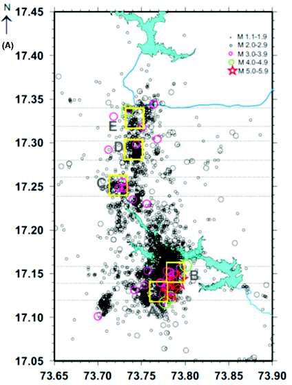
Koyna, India, An Ideal Site for Near Field Earthquake Observations                                                      471

Fig. 1A: (Updated from Gupta et al. (2017). Koyna-Warna
         region near west coast of India. Location of the
         Koyna main earthquake of December 10, 1967;           Fig. 1B: Depth section of M ~ 5 earthquakes (epicenters
         earthquakes of M ~ 5 during August 1967 through                shown in (A) along latitudes (i) and longitudes (ii);
         June 2017; smaller earthquakes from August 2005                and depth sections of M≥3.5 earthquakes along
         through June 2017; surface and borehole seismic                latitude (iii) and longitude (iv). Symbols same as in
         stations; green curve indicates the WGE (Western               (Fig. 1A). The concentration of hypocenters along
         Ghat Escarpment). (I) Koyna location in India; (II)            73.75 o E is noticeable that corresponds to
         Distribution of M≥3.7 earthquakes for 1967-2015                Donachiwada Fault (Fig. 7)
         (USGS) in the vicinity of Koyna and an outer circle
         of 100 km radius indicating that there is almost no
         seismic activity outside the Koyna region             factors like rate of loading, highest water level
                                                               reached and duration of retention of high water levels
                                                               directly affected RTS at Koyna. In another study, it
after the peak water levels are reached in the two             was found that a rate of loading of 13 m/week was a
reservoirs. It may be noted that the first M ≥ 5 RTS           necessary but not a sufficient condition for M ≥ 5
event in the region occurred on September 13, 1967.            earthquakes to occur in the Koyna region (Gupta
Another peak is reached in December, which is not              1983). It was also seen that whenever the previous
as prominent as the September peak. The largest M              water level maxima was exceeded at Koyna/Warna
6.3 earthquake in 1967 also occurred in December.              reservoirs and/or high water levels were retained for
There were several M ~ 5 aftershocks of the main               longer durations, M ~ 5 earthquakes occurred (Gupta
December 10, 1967 earthquake that had a magnitude              et al., 2002).
of M ~ 6.3. However, in later years only two M ~ 5
earthquakes occurred in the month of December. The             How the RTS Earthquake Sequences Differ from
frequency of M ≥ 4 earthquakes in January is quite             Normal Earthquake Sequences?
low and later a peak is seen in March, which
corresponds to a higher rate of emptying the reservoir.        By early 1970s, over a dozen cases of RTS were
In a recent study (Shashidhar et al., 2016), a spurt in        known. A major question had been to discriminate a
seismic activity in the month of March 2015 was                RTS event from a normal event. Detailed studies of
observed, and it was pointed out that when unloading           these RTS sequences lead to identification of four
rate in the Koyna Reservoir increased from 0.053 to            common characteristics which discriminate RTS
0.170 m/day and in the Warna Reservoir from 0.065              sequences from the normal regional earthquake
to 0.106 m/day during the 3rd week of March 2015,              sequences occurring in close by regions, but not
there was a spurt in RTS.                                      associated with the reservoirs (Gupta et al., 1972 a
                                                               & b). These are: i) In the earthquake frequency-
     In some earlier studies (Gupta et al., 1972 a &           magnitude relation (log N=A-b M, where N is the
b; Gupta and Rastogi, 1974), it was observed that              number of earthquakes with magnitude ≥ M, and A
472                                                                                                      Harsh K Gupta

Fig. 2: Annual cycles of loading and unloading of the Koyna (A) and Warna (B) reservoirs for the period of 2005 through 2017
        (updated from Gupta et al., 2017). The reservoirs get loaded following the Monsoon (for details see the text)

                                                                 be a major earthquake releasing most of the strain,
                                                                 followed by peripheral adjustment aftershocks. In such
                                                                 a sequence, there would not be any foreshocks, the
                                                                 aftershock activity would be over in a short time, the
                                                                 ratio of the largest aftershock to the main event would
                                                                 be low, and the b value would be also low. This is
                                                                 typically the situation with the earthquake sequences
                                                                 in stable continental regions not associated with the
                                                                 reservoir loading. Due to filling of the water reservoir,
                                                                 the heterogeneity of the media increases (Fig. 4 (II)B),
                                                                 and the rock volume gets fragmented. As a
Fig. 3: Monthly number of M ≥ 4 earthquakes in the Koyna         consequence the accumulated strain is released
        region for the period 1967 through 2016. There is a      through smaller rock volumes. In such a situation, the
        spurt in seismic activity soon after loading of the      earthquakes would start occurring as and when the
        reservoirs (end of August-September). Another peak
        appears in December. The third peak is associated
                                                                 strength of an individual rock volume is exceeded.
        with fast draining of the reservoirs in March            The main earthquake would correspond to the largest
                                                                 rock volume and there would be foreshocks and
                                                                 aftershocks, changing the pattern from Type I of
and b are constants), the fore-shock and after-shock             Mogi’s (1963) Model to Type II. These criteria are
b values of the RTS sequences are higher than the                helpful in identifying whether an earthquake sequence
regional and normal earthquake sequences b values.               occurring in the vicinity of a reservoir is triggered or
ii) The ratio of the magnitude of the largest aftershock         normal. Safer sites for locating artificial water
to the main shock is high. iii) The decay of aftershocks         reservoirs are determined by doing in-situ-stress
in the RTS is slower. iv) The foreshock- aftershock              measurements and assessing how close to critical a
pattern of RTS sequences belongs to Type II of Mogi’s            site is stressed, and whether filling of the reservoir
Model (Fig. 4), whereas the natural earthquake                   would trigger the earthquakes (Gupta, 1992). This
sequence pattern belongs to Type I. These                        model of RTS, developed in 1970’s was based on the
characteristics are governed by the mechanical                   observations at about a dozen RTS sites. Now over
properties of the media, and their deviation from the            120 sites are globally known where RTS has been
normal implies that the filling of the reservoir has             observed and these criteria are found to be applicable
changed them by introducing heterogeneity in the                 (Gupta, 2011). One of the recent examples is reported
media. This can be best illustrated from Fig. 4. In Fig.         from Vietnam (Cao Dinh Trieu et al., 2014).
4(II) “A” is a homogenous media rock volume. When
the stress exceeds the strength of the rock, there would
Koyna, India, An Ideal Site for Near Field Earthquake Observations                                                  473

                                                               noted that DVP is basically a trust fault regime
                                                               (Rajendran et al., 1992). The Latur earthquake focal
                                                               mechanism is also trust fault dominated (Gupta et al.,
                                                               1997). However, the earthquakes in the Koyna region
                                                               are basically left-lateral strike-slip and/or normal fault
                                                               dominated (Rao and Shashidhar, 2016). Rastogi (1994)
                                                               compared the Latur earthquake sequence with the
                                                               Koyna earthquake sequence and found that the Latur
                                                               sequence had low ‘b’ values, low largest aftershock
                                                               magnitude to the main shock magnitude ratio; in
                                                               addition to not having foreshocks and the seismic
                                                               activity getting over in a rather short time, contrary to
                                                               the characteristics of Koyna earthquake sequences.

                                                               How Long RTS will Continue at Koyna?
                                                               At most of the RTS sites, triggered earthquakes start
                                                               to occur soon after the impoundment of the reservoir
                                                               and continue for different lengths of time varying from
                                                               a few years to a decade or so. The Hsingfengkiang
                                                               Reservoir, China was impounded in 1959 and soon
                                                               after that triggered earthquakes started to occur. The
                                                               largest triggered earthquake of M 6.1 occurred on
                                                               March 19, 1962 (Chung-Kang et al., 1974). However,
                                                               while in early sixties thousands of earthquakes
                                                               occurred every month, their number dropped to a few
Fig. 4: (I) Depicts Mogi’s (1963) classification of the
        earthquake sequences into three broad categories       by 1978 (Ishikawa and Oike, 1982; Gupta, 1992).
        (Mogi, 1963 b). (II) Cartoon for (A) for homogenous    Lake Kariba, Zambia-Zimbabwe border, was
        rock mass, and (B) fragmented rock mass. For details   impounded in 1958. The levels kept increasing every
        see the text                                           year and a peak level was reached in 1963. This was
                                                               followed by an immediate burst of triggered
                                                               earthquakes, including the M 6.2 earthquake on April
      It would be appropriate at this stage to point out       23, 1963 (Pavlin and Langston, 1983). In the following
that Stable Continental Regions (SCR) are very quite           years, a few M ~ 5 earthquakes occurred in the vicinity
parts of the continent. It is estimated that the strain        of the lake. However, the activity ceased in the
accumulation in such regions is of the order of (10–9)         following years (Gupta, 1992). Same is the case with
to (10–10) per year as compared to (10–7) to (10–9) for        the Lake Kremasta in Greece, which was impounded
the intra-plate region and (10–5) to (10–7) at the plate       in 1965, with very rapid loading in January 1966 and
boundaries (Johnston, 1993; Gupta and Johnston,                the largest triggered earthquake of M 6.2 occurred
1998). RTS is mostly found to be occurring in SCRs.            on February 5, 1966. In the months to follow the
The occurrence of M 6.2 Latur earthquake on                    earthquake frequency dropped considerably
September 29, 1993 in the same Deccan Volcanic                 (Galanopoulos, 1967; Stein et al., 1982).
Province, some 300 km east of the Koyna earthquake
of December 10, 1967 provided an excellent                          Unlike the above mentioned cases of RTS where
opportunity to compare the two earthquake                      M≥6 earthquakes had occurred and RTS stopped
sequences. The Latur earthquake occurred at 22h                within a few years to a decade, triggered earthquakes
25m UTC on 29th Sept. 1993 (corresponding to 3h                have continued to occur at Koyna till now, that is some
55m IST on 30 Sept). The earthquake claimed some               55 years after the impoundment of the Shivaji Sagar
11,000 human lives becoming the deadliest SCR                  Lake created by the Koyna Dam. The latest M ~ 4
earthquake till then (Gupta et al., 1997). It may be           earthquake occurred on June 3, 2017. The magnitude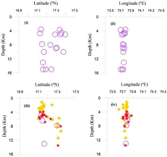
474                                                                                                          Harsh K Gupta

Fig. 5: The study area indicating the installation or deployment plan of the various experiments undertaken in the preparatory
        phase of the deep drilling programme. Earthquakes of M ≥ 3.0 occurred during August 2005 to December 2013. MT-1
        and MT-2 indicate the magnetotelluric profiles passing through Rasati in the north and Udgiri in the south, respectively.
        The area covered by LiDAR is enclosed by M ≥ 3.0 the brown line (Gupta et al., 2014)

and frequency of the largest possible earthquakes in               is a simple calculation:
the stable continental region has been debated (for
example Johnston 1994). It has been hypothesized                   Energy Released in Koyna Region
that the maximum credible earthquake in the Koyna                  The Max. Credible Earthquake (MCE) considered for
region is of M 6.8 and the region was stressed close               Koyna: M = 6.8
to critical before the impoundment of the Koyna Dam
(Gupta et al., 2002). As explained in the earlier                  Empirical relation used: Log E = 1.5 M + 11.8, (M
section of this article, creation of the reservoir                 = magnitude)
introduces heterogeneity in the media and earthquakes
                                                                          Using the above relation EMCE = 10 22 ergs
start to occur as and when the strength of an individual
rock volume is exceeded. Considering that so far 22                Energy released so far:
M ~ 5, some 200 M ~ 4 and thousands smaller
earthquakes have occurred in the region, the following             Ø Case 1: Average magnitude of 22 M ~ 5, and 200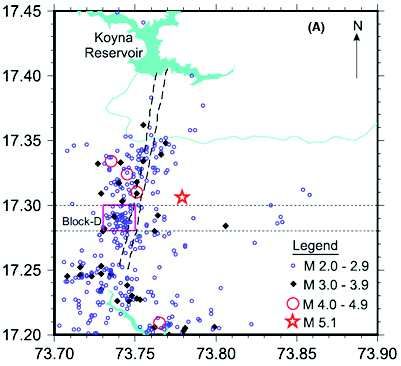
Koyna, India, An Ideal Site for Near Field Earthquake Observations                                               475

M ~ 4 events taken as 5.5 and 4.5:                            focal depths, at a classical RTS site in an intra-plate
                                                              setting, 3). To prepare a complete drilling plan, 4). To
E = 1 x EM6.3 + 22 x EM 5.5 + 200 x EM 4.5                    plan the entire array of measurements/monitoring
  = 10(21.25) + 22x10(20.05) + 200x10(18.55) = 1021.94        opportunities provided by deep drilling in consultation
                                                              with national and international experts, 5). To develop
Percentage of MCE = 1021.94 / 1022 = 87 %                     a full proposal on scientific drilling at Koyna. The
Ø Case 2: Average magnitude of 22 M ~ 5, and 200              workshop was attended by 26 participants from
M ~ 4 events taken as 5.3 and 4.3:                            abroad and 50 participants from India. They have had
                                                              experience with San Andreas Fault Observatory at
     E = 1 x EM6.3 + 22 x EM 5.3 + 200 x EM4.3                Depth (SAFOD); the Chelungpu Fault Drilling Project
                                                              in Taiwan; the Nojima Fault Drilling in Japan; the Gulf
       = 10(21.25) + 22x10(19.75) + 200x10(18.25) = 1021.51   of Corinth in Greece; and the Latur Fault in India. All
     Percentage of MCE = 1021.51 / 1022 = 32 %                the participants at the workshop agreed that Koyna
                                                              is a world-class geological site and a natural
      Considering the average of the two extreme              earthquake laboratory to conduct a deep bore hole
scenarios, about 60% energy of an M 6.8 earthquake            experiment to study earthquakes in near field. The
has been released in the Koyna region. It is further          Ministry of Earth Sciences (MoES) declared full
noted that no M ~ 5 earthquake epicenter has repeated         support to the Koyna Project and ICDP offered to
in the region (Fig. 1). This leads to a conclusion that       provide all technical support. Based on the
RTS in Koyna region shall continue for another 2 to 3         presentations in the workshop and the experience of
decades.                                                      the participants, several suggestions for scientific
                                                              work were made before initiating the deep drilling
Is Koyna a Suitable Site for Scientific Deep
                                                              program. These included improving hypocenter
Drilling?
                                                              location capabilities in the Koyna region; airborne
A number of studies have already established the              gravity-gradient and magnetic surveys; seismic
association of Monsoon driven loading and unloading           reflection studies; LiDAR; Magneto-telluric surveys;
of the Koyna and Warna reservoirs with the RTS in             study hydraulic connectivity and based upon the results
the Koyna region. However, the triggering mechanism           of the above surveys, plan the Deep Borehole Drilling
is poorly understood. We know precious little about           Project.
the physical properties of the rocks and fluids in the
                                                                   During the period 2011-2014, the suggested
fault zone and what role they play in sustaining
                                                              investigations were undertaken through support of the
triggered earthquakes for over 5 decades due to lack
                                                              MoES. These included:
of near field observations. The earthquakes occur in
a small area of 20 km x 30 km, are shallow (mostly            1)   Drilling 9 exploratory boreholes penetrating the
between 2 and 9 km depth), the region is totally                   basalt cover and getting 300- 500 m into the
accessible, the RTS has continued for over 5 decades               granitic basement for studying sub-surface
and there is no other earthquake source within 50 to               geology and rock properties; 2) Airborne gravity
100 km of Koyna Dam. This makes Koyna physically                   gradiometry and magnetic surveys to delineate
and logistically a very suitable location for the near             3D subsurface structure in the Koyna region,
field observation of earthquakes. It was felt necessary            specifically covering the RTS area; 3).
to share this view with the international community                Magnetotellurics to map subsurface electrical
and an International Continental Drilling Program                  conductivity and estimate the thickness of
(ICDP) workshop was held at Hyderabad and Koyna                    Deccan Traps; 4) Airborne LiDAR surveys to
during March 21-26, 2011 (Gupta and Nayak, 2011).                  get high resolution topographic information and
The objectives were: 1). To provide an international               prepare a bare earth model; 5) Heat-flow
forum for sharing and exchange of lessons learned                  measurements and modeling of the subsurface
from investigations on RTS worldwide including                     temperatures; and 6). Instrumenting 6 bore holes
Koyna, 2). To brain storm on the scientific motivation             with 3-component seismometers meters at
behind deep drilling in an active fault zone down to               depths of ~ 15,00 m to better estimate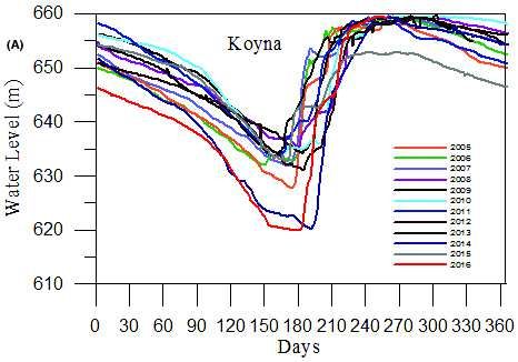
476                                             Harsh K Gupta

      Fig. 6: (A) Seismicity of the Koyna-Warna region during
              2009-2014. The five Blocks A, B, C, D and E are each 2
              X 2 km2 in area. Dotted lines indicate a swath of 2 km
              area at each Block. (B) Depth sections for 2 km swath
              for the 5 blocks. With in brackets are indicated the
              number of earthquakes that occurred in each of these
              blocks

            earthquake parameters. Figure 5 adopted from
            Gupta et al (2017) shows the installation and
            deployment of various experiments. The major
            discoveries of this phase are as follows (Gupta
            et al., 2014&2017):
      a)    There has been a long debate about the presence
            of Mesozoic sediments below the basalt cover.
            No such sediments were found.
      b)    It was discovered that the thickness of the basalt
            column is directly related with topography.
            Although, the topography in the area covered is
            almost ~1000 m, the basement is almost flat with
            variation of no more than 100 m, and lies about
            300 m below the present mean sea level.
      c)    One of the requirements for setting up a borehole
            laboratory is not to have very high temperatures.
            The temperature was estimated to be ~ 150oC
            at 6 km depth.
      d)    The basalt-basement contact was clearly
            identified through MT response. A direct
            correspondence was found in resistivity as
            inferred from MT surveys and the week zones
            in the region.
      e)    Hypocenters are associated with sharp density
            contrast and resistivity changes.
      f)    Geological/geophysical logging in 8 boreholes has
            revealed the alignment of prominent faults.
      g)    LiDAR surveys led to developing bare earth
            model of the region and identification and
            demarcation of the Donachiwada Fault which
            hosted the 1967 earthquake and most M ~ 5
            earthquakes in the region.
      h)    Operation of borehole seismometers reduced
            the absolute errors in location of earthquakes
            from ~ 800 m to 300 m.
          The above work was discussed in the 2nd ICDP
      workshop held at Koyna during 16 to 18 May 2014 at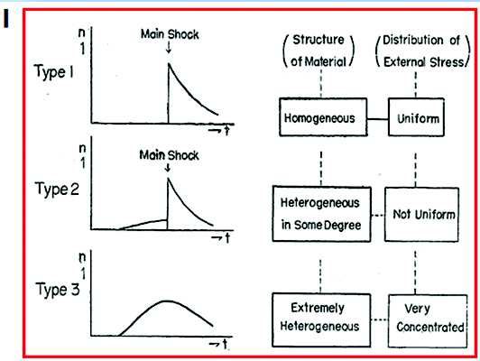
Koyna, India, An Ideal Site for Near Field Earthquake Observations                                                477

                                                               RTS in Koyna region, 5 blocks for possible location
                                                               of the Pilot Borehole(s) were identified (Gupta et al.,
                                                               2017). It was kept in mind that that there should be
                                                               enough repeating earthquakes with in a depth of 5
                                                               km of magnitude M 2, being the magnitude of the
                                                               target earthquake. Two of these locations (A and B
                                                               in Fig. 6) were south of Warna Reservoir and the
                                                               remaining 3 north of Warna Reservoir (C, D, & E)
                                                               just short of the Koyna Reservoir (Fig. 6). Considering
                                                               several logistic constraints, particularly to be out of
                                                               the demarcated forest cover, finally a location within
                                                               site D was selected (Fig. 7). It may be noted in Fig. 7
                                                               that the Donachiwada Fault zone is in the immediate
                                                               vicinity of this site. During the period August 2005
                                                               through December 2015, the site hosted 3 earthquakes
                                                               of M 3.0 to 3.9 and 59 earthquakes of M 2.0 to 2.9.

                                                               The Pilot Borehole
                                                               The Pilot Borehole was spudded on December 20,
                                                               2016 and the drilling of 3000 m was completed on
                                                               11th June 2017. Figure 8 provides the well configuration
                                                               and a general lithology of the pilot borehole. The
                                                               basement was reached at a depth of 1247 m. It may
                                                               be noted that in a nearby borehole at Panchgani the
                                                               basement was at a depth of 1252 m. Here also, no
                                                               sediments were encountered at the bottom of the
                                                               basalt column. It is interesting to note that several
Fig. 7: (A) Earthquakes of magnitude ≥ 2.0 that occurred
        during August 2005-December 2015. Dotted lines
                                                               zones with immense fluid losses were encountered.
        indicate a swath of 2 km area of the Block-D. Dashed   Detailed geophysical logging has been carried out.
        line indicates the Donachiwada fault zone. (B) Depth   With the help of ICDP, on-line-gas analyses (OLGA)
        section for the 2 km wide swath in (a) above. Dotted   facility had been set up. Cores were recovered from
        lines indicate the area 2 x 2 km 2
                                                               depths of 1679, 1892 and 2091 m depths. These are 9
                                                               m long and 4 inch diameter cores and there was
                                                               almost 100% recovery. In-situ stress measurements
(Gupta et al., 2014). The workshop was attended                have been carried out at depths of 1600 m and deeper.
by12 participants from abroad and 37 from India. The           All the data acquired are being analyzed.
work carried out since the first workshop in 2011 was
presented and discussed. A plan for Pilot Borehole(s)          Concluding Remarks
drilling was also presented. There were detailed
discussions on various aspects of drilling, location and       RTS that got initiated in 1962 soon after the filling of
completion of the Pilot Borehole(s). Based on the              the Shivaji Sagar Lake created by the Koyna Dam
hypocenter locations 5 possible sites for the location         has continued till now. RTS is seen to be mostly
of the Pilot Borehole(s) were suggested. It was                occurring in Stable Continental Regions. For the
unanimously concluded that Koyna is one of the best            Koyna region it is hypothesized that the region was
sites anywhere in the world to investigate genesis of          critically stressed before the impoundment of the
RTS from near field observations.                              reservoir(s) and it could host an M 6.8 earthquake.
                                                               However, heterogeneity introduced by the reservoir
Location of the Pilot Borehole                                 has fragmented the rock mass. So far about 60%
                                                               energy of an M 6.8 earthquake has been released.
Based on the hypocenters during 2009 to 2014 in the            Loading and unloading of Koyna and Warna reservoirs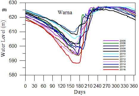
478                                                                                                   Harsh K Gupta

                                                                Koyna gave an excellent opportunity to compare the
                                                                two earthquake sequences and demonstrate the
                                                                difference between the two. As earthquake epicenters
                                                                are confined to an area of 20 km x 30 km, the focal
                                                                depths being mostly between 2 and 9 km, the
                                                                accessibility to Koyna region and the fact that there
                                                                is no other seismic source within 100 km of Koyna
                                                                Dam, make it a suitable site for near field studies of
                                                                earthquakes. This was discussed in the first ICDP
                                                                Workshop, where the site was found to be very
                                                                appropriate for near field studies. However, a few
                                                                suggestions for further work were made to be under
                                                                taken before setting up deep bore hole drilling program.
                                                                These were carried out during 2011 to 2014 with
                                                                support from MoES. In the second ICDP workshop
                                                                in 2014, the results of the work having been carried
                                                                out as well as plan of the Pilot Borehole were
                                                                presented. These were supported and during 2014 to
                                                                2017, the location of the Pilot Borehole was finalized
                                                                and the 3 km deep Pilot Bore Hole was completed
                                                                with all the necessary measurements having been
                                                                carried out. The analysis of the measurements having
                                                                been made in the Pilot Borehole is under progress.

                                                                Acknowledgements
                                                                Several colleagues at the National Geophysical
                                                                Research Institute (NGRI), Hyderabad made it
                                                                possible to reach the present level of work in the Koyna
                                                                region. Successive Directors of NGRI, namely Drs.
                                                                V. P. Dimri; Y. J. Bhaskar Rao, Mrinal Sen and V. M.
Fig. 8: Generalized configuration of the 3000m deep pilot       Tiwari supported the Koyna Program. Support of
        borehole, giving the drilling and casing details. The
                                                                Ministry of Earth Sciences, particularly that of Dr. P.
        borehole entered the basement at a depth of 1247 m
        after penetrating through the basalt column.
                                                                S. Goel and Dr. Shailesh Nayak is acknowledged for
        Practically no sediments were encountered below the     their understanding and support of the Koyna Program.
        basalt column, which is lying directly on the pre-      The support from MoES continues with the current
        Cambrian granite-gneiss basement                        Secretary Dr. Madhavan Nair Rajeevan. Dr. Brijesh
                                                                K. Bansal, Program Coordinator for Earth Science
                                                                Program of MoES deserves a special mention
influences RTS in the region. RTS is influenced by              because of his whole-hearted support all these years.
rate of loading, highest water levels reached and               Dr. Arun K. Gupta of MoES has been of much help.
duration of retention of high water levels. Whether             At the International Continental Drilling Program
previous water maxima is exceeded or not is related             office, Prof. Rolf Emmermann, Dr. Uli Harms, Dr.
to the occurrence of M ~ 5 earthquakes. Global study            Brian Horsfield and Carola Knebal have been very
of RTS sequences has led to discovering their                   helpful in providing technical support as well as
common characteristics that differentiate them from             organizing the ICDP Workshops. Dr. M.
normal earthquake sequences occurring in the same               Ravichandran and Dr. Rahul Mohan of NCAOR
region. Occurrence of an M 6.2 Latur earthquake on              provided much needed support for running the Koyna
29th September 1993 in same DVP some 300 km from                Project.
Koyna, India, An Ideal Site for Near Field Earthquake Observations 479
References Earthquakes, Encyclopedia of Solid Earth Geophysics,
Springer+ Business media, 1, pp. 15-24
Cao Dinh Trieu, Cao Dinh Trong, Le Van Dung, Thai Anh Tuan
and Dinh Quoc Van, Ha Vinh ong (2014). “Triggered Gupta H K and Nayak S (2011) Deep Scientific Drilling to Study
Earthquake study in Tranh River No. 2 (Vietnam) Reservoir-Triggered Earthquakes in Koyna, Western India
Hydropower Reservoir Scientific Drilling 12 53-54
Carder D S (1945) Seismic investigations in the Boulder Dam Gupta H K, Prantik Mandal and Rastogi B K (2002) How long
area, 1940-1944, and the influence of reservoir loading on will triggered earthquakes at Koyna, India continue?
earthquake activity Bulletin of the Seismological Society of Current Science 82 202-210
America 35 175-192 Gupta H K, Purnachandra Rao N, Sukanta Roy, Kusumita Arora,
Chung-Kang S, Hou-chun C, Chu-han C, Li-Sheng H, Tzu-chiang Tiwari V M, Patro B P K, Satyanarayana H V S, Shashidhar
L, Chen-yung Y, Ta-chun W and Hsueh-hai L (1974) D, Mallika K, Vyasulu V Akkiraju, Goswami D, Vyas D,
Earthquakes induced by reservoir impounding and their Ravi G, Srinivas K N S S S, Srihari M, Mishra S, Dubey C
effect on the Hsingengkiang Dam Science Sinica 17 239- P, Ch V Raju, Ujjal Borah, Chinna K Reddy, Narendra
272 Babu, Sunil Rohilla, Upasana Dhar, Mrinal Sen and Bhaskar
Rao Y J (2014) Investigations related to scientific deep
Galanopoulos A G (1967) The large conjugate fault system and
drilling to study reservoir-triggered earthquakes at Koyna,
the associated earthquake activity in Greece Ann Geol
India, International Journal of Earth Sciences DOI 10.1007/
Pays Helleniques (Athens) 18 119-134
s00531-014-1128-0
Guha S K, Gosavi P D, Varma M M, Agarwal S P, Padale J G and
Gupta H K, Shashidhar D, Mahato C R, Satyanarayana H V S,
Marwadi S C (1970) Recent seismic disturbances in the
Mallika K, Purnachandra Rao N, Maity B S and Navitha
Shivajisagar Lake area of the Koyna Hydro-electric Project
K (2017) Location of the pilot borehole for investigations
Maharashtra, India, 2. Rep. C.W.P.R.S., 25pp
of reservoir triggered seismicity at Koyna, India
Gupta H K, Narain H, Rastogi B K and Mohan I (1969) A study
Gondwana Research, Elsevier 42 133-139
of the Koyna earthquake of Dec.10, 1967 Bulletin of
Ishikawa M and Oike K (1982) On reservoir-induced earthquakes
Seismological Society of America 59 1149 1162
in China Zishin 35 171-181
Gupta H K, Rastogi B K and Narain H (1972a) Common features
Johnston A C (1993) Average stable continental earthquake source
of the reservoir associated seismic activities Bulletin of
parameters based on constant stress drop scaling,
Seismological Society of America 62 481-492
Abstracts, 65 th Annual meeting, Eastern Section
Gupta H K, Rastogi B K and Narain H (1972b) Some
Seismological Society of America, SRL 64 261
discriminatory characteristics of earthquakes near the
Johnston A C (1994) Report on the Session on Latur Earthquake
Kariba, Kremasta and Koyna artificial lakes Bulletin of
at IASPEI XXVII General Assembly by H.K.Gupta.
Seismological Society of America 62 493 507
IUGG Chronicle, N 221, April/May1994, pp. 80
Gupta H K and Rastogi B K (1974) Will another damaging
Mane P M (1967) Earth tremors in the Koyna Project area. 9th
earthquake occur in Koyna? Nature 248 215 216
Congr. On Large Dams, Istanbul, 1967. Commission
Gupta H K (1983) Induced seismicity hazard mitigation through
Internationale des Grands Barrages, Paris, pp. 509-518
water level manipulation at Koyna, India: A suggestion,
Mogi K (1963) Some discussions on aftershocks, foreshocks and
Bulletin of Seismological Society of America 73 679 682
earthquake swarms-the fracture of a semi-infinite body
Gupta H K (1992) ‘Reservoir Induced Earthquakes’, Elsevier
caused by an inner stress origin and its relation to the
Scientific Publishing Company, Amsterdam, 364 p
earthquake phenomena Bull Earthquake Res Inst 41 615-
Gupta H K, Rastogi B K, Indra Mohan, Rao C V R K, Sarma S V 658
S and Rao R U M (1997) An investigation into the Latur
Narain H and Gupta H K (1968) The Koyna Earthquake Nature,
Earthquake of September 29, 1993 in Southern India,
217 1138-1139
Tectonophysics 287 299 318
Pavlin G B and Langston C A (1983) An integrated study of
Gupta H K and Arch C Johnston (1998) ‘Stable Continental
reservoir induced seismicity and Landsat. Imagery of Lake
Regions Are More Vulnerable to Earthquakes than Once
Kariba, Africa Photogramm Eng Remote Sensing 49 513-
Thought’ (Chapman Conference Report), EOS
525
Transactions 79 319 321
Rajendran K, Talwani P and Gupta H K (1992) ‘State of Stress in
Gupta H K (2011) Artificial Water Reservoir Triggered480 Harsh K Gupta
the Indian Subcontinent A review’. In Special Issue on 35 131-137
Seismology in India an Overview Current Science 62 86 Shashidhar D, Satyanarayana H V S, Mahato C R, Mallika K,
93 Rao N P and Gupta H K (2016) Borehole Network at
Rao N P and Shashidhar D (2016) Periodic variation of stress Koyna India Seismological Research Letters, Early edition
field in the Koyna–Warna reservoir triggered seismic zone Stein S, Wiens D A and Fujita K (1982) The 1966 Kremasta
inferred from focal mechanism studies, Tectonophysics reservoir earthquake sequence Earth Planet Sci Lett 59 49-
Elsevier 679 29-40 60
Rastogi B K (1994) “Latur Earthquake: Not Triggered”, Latur Talwani P (1997) On the nature of reservoir induced seismicity
Earthquake, Journal Geological Society of India, Memoir Pure and Applied Geophysics 150 511-550.You can also read