Line CROP 11: Central Apennines - La linea CROP 11: Appennino Centrale
←
→
Page content transcription
If your browser does not render page correctly, please read the page content below
Mem. Descr. Carta Geol. d’It.
                                                                                                                                    LXII (2003), pp. 145-154
                                                                                                                                                       6 figg.

Line CROP 11: Central Apennines
La linea CROP 11: Appennino Centrale
                                                 PAROTTO M. (1), CAVINATO G.P. (2), MICCADEI E. (3), TOZZI M. (2)

     ABSTRACT - The CROP 11 profile extends for 265 km
from Marina di Tarquinia (on the Tyrrhenian coast) to Vasto                          1. - INTRODUCTION
(near Pescara, on the Adriatic coast). The line presents a west-
east direction in order to study the crustal structure of this seg-                       The CROP 11 profile extends for 265 km
ment of the Apenninic chain where the northern and southern
Apenninic arcs join together. On the surface the trace of the                        across Central Italy, from Marina di Tarquinia (on
profile cuts across the Apenninic chain, from the Burdigalian                        the Tyrrhenian coast) to Vasto (on the Adriatic
foredeep in the west to the recent Pliocene foredeep overlying                       coast), crossing, at as high an angle as possible, the
the Adriatic foreland. CROP 11 was acquired in two periods:
the first 109 km in 1996 and a further 156 km in 1999. Pro-                          main tectonic structures of the central Apennines
cessing of CROP 11 started in 1997 and was completed at the                          (fig. 1). The line was acquired in two stages: the first
end of 2001. Data interpretation is still under way.                                 109 km in 1996 and the second 156 km in 1999.
     KEY-WORDS: Central Apennines, reflection seismic, crust,                        Processing of the CROP 11 lines began in 1997 and
structural setting                                                                   was completed at the end of 2001. Starting in 1989,
                                                                                     the CROP 11 working groups, which include people
      RIASSUNTO - Il profilo CROP 11 si estende per 265 km
                                                                                     from universities, CNR and industrial research
attraverso l’Italia centrale, tra Marina di Tarquinia, sulla costa                   structures, participated in the various phases of the
tirrenica, e Vasto, sulla costa adriatica. La sua direzione è                        CROP 11 project (TOZZI et alii, 1992). The CROP
sostanzialmente Ovest-Est ed è stato progettato per analizzare                       11 working groups are currently interpreting data
la struttura crostale in un settore in cui si affiancano i due gran-
di “archi” formati dalle strutture appenniniche settentrionali e                     from the eastern part of the NVR profile, which
centro-meridionali; in superficie, il profilo attraversa l’intero                    extends from Vasto to Maiella; these data will be
orogeno, dai resti della fase burdigaliana fino all’avanfossa più                    calibrated and substantially improved by integration
recente, e raggiunge l’avampaese. La linea è stata acquisita in
due fasi: nel 1996 (109 km) e nel 1999 (156 km); il processing                       with information provided by ENI-AGIP, mainly
è iniziato nel 1997 e si è completato nel 2001. Attualmente è in                     consisting of commercial seismic profiles and bore-
corso l’interpretazione.                                                             hole data.
     PAROLE CHIAVE: Appennino Centrale, sismica a riflessione,                            Preliminary studies directed at the acquisition of
crosta, assetto strutturale                                                          the CROP 11 deep seismic line provided us with the

(1) Dipartimento di Scienze Geologiche, Università degli Studi “Roma Tre”, Largo S. Murialdo 1 - 00146 Roma.
(2) Istituto Geologia Ambientale e Geoingegneria-CNR, c/o Dip. Scienze della Terra, Università degli Studi di Roma “La Sapienza”, P.le A. Moro 5 - 00185 Roma.
(3) Dipartimento di Scienze della Terra, Università degli Studi “G. D’Annunzio”, via dei Vestini 30, 66100 Chieti.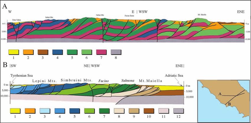
146                                         PAROTTO M. - CAVINATO G.P. - MICCADEI E. - TOZZI M.

            Fig. 1 - Geologic framework of Central Italy and position of the CROP 11 seismic line and DSS geophysical data.
                         - Schema geologico dell'Italia centrale e posizione della linea sismica CROP 11e dei dati geofisici DSS.

opportunity to review and revise all the geological                       Sasso and Maiella thrust sheets (fig. 1). Additional
and geophysical data available for Central Italy.                         thrusts and related folds are concealed beneath
                                                                          several km of Pliocene-Quaternary syn-orogenic
                                                                          sediments northeast of the topographic front of
2. - THE GEOLOGICAL SETTING OF THE                                        the range (fig. 1; BIGI et alii, 1992; PATACCA et alii,
     CENTRAL APENNINES                                                    1992; CIPOLLARI & COSENTINO, 1997; GHISETTI &
                                                                          VEZZANI, 1997). The exposed sequences consist of
      The central Apenninic chain is a Neogene fold-                      thick Triassic-middle Miocene carbonate platform,
and-thrust belt that developed on ensialic crust after                    slope and ramp facies (from 5 to 3 km thick; fig. 1;
the Europe-Africa collision during the Alpine oro-                        BALLY et alii, 1986). The kinematic history of thru-
geny (ROYDEN et alii, 1987; DOGLIONI, 1991; BIGI et                       sting in the central Apennines is recorded by Mio-
alii, 1992; CAVINATO & DE CELLES, 1999). Four main                        cene through Pliocene syn-orogenic sediments in
geodynamic provinces can be recognized in the cen-                        foredeeps, which were progressively involved in the
tral Apennines (from east to west) (fig. 1): a defor-                     chain towards the Adriatic foreland (PATACCA et alii,
med intra-orogenic foreland (Apulia-Adriatic) made                        1992; CIPOLLARI & COSENTINO, 1997; CIPOLLARI et
up of several blocks that have undergone rotation                         alii, 1997). Starting in the Messinian and continuing
in different directions and of varying degrees since                      through the Early Pliocene, multi-phased deforma-
the Late Cretaceous; 2) a deformed foredeep                               tional events formed NW-SE and NNW-SSE thrust
(Adriatic trough) that is widely overthrust by the                        sheets (Lepini, Simbruini, Velino-Magnola, Sirente,
Apenninic chain; 3) a thrust belt (Apennines) that                        Marsica units; fig. 1). The Olevano-Antrodoco and
developed from the Early Cenozoic to the Pleisto-                         Gran Sasso thrust systems are significant out-of-
cene; and 4) a hinterland (Tyrrhenian basin), inclu-                      sequence thrusts that truncate some of the north to
ding large volcanic centers, that is now undergoing                       northwest-striking systems (fig. 1; CIPOLLARI &
extensional tectonics.                                                    COSENTINO, 1997; GHISETTI & VEZZANI, 1997).
      The major thrust systems in the central Apenni-                           NW-SE and E-W high-angle normal fault
nes strike NW-SE and dip gently towards the south-                        systems, generally southwest and south-dipping,
west. They include, from SW to NE: the Lepini,                            and extensional basins, of generally post-Messinian
Simbruini, Velino-Sirente, Marsica, Morrone, Gran                         age, formed across the southwestern part of the
LINE CROP 11: CENTRAL APENNINES 147
thrust belt and are superimposed upon the com- for Central Italy. These preliminary CROP 11 cross-
pressional Neogene structure (CAVINATO & DE CEL- sections were largely influenced by the different
LES, 1999) (fig. 1). The extensional basins were pro- interpretations of researchers working in the same
gressively filled by alluvial and lacustrine deposits. area (CROP 11 working group). The authors cannot
The major Pliocene-Quaternary extensional basins involve the basement in the thrust belt in the inter-
include Tiberino, Rieti, L’Aquila, Fucino, and Sul- pretations of figure 2. The main problems were the
mona basins (fig. 1). geometry of extensional tectonics, the importance of
The evolution of these geodynamic units sug- the main NW-SE and N-S transcurrent lineaments,
gests: the flexural retreat towards the NE of the the occurrence of out-of-sequence thrusts and the
edge of the Adriatic block, with a passive sinking of probable occurrence of block rotations.
the lithosphere and associated roll-back mecha-
nisms (ROYDEN et alii, 1987; DOGLIONI, 1991) and
the progressive eastward advance of the Apenninic 3. - GEOPHYSICAL DATA
chain with in-sequence and out-of-sequence faults,
transport of piggy-back basins and incorporation Using the updated geological and geophysical
of fore deep basins. Strike-slip faulting and rota- data, we propose a model of the deep structure
tions have severely complicated the relationships underneath Central Italy, assuming that a subduc-
among the geodynamic units, both in the chain and tion mechanism took place.
in the foreland (MOSTARDINI & MERLINI, 1986; The general negative slope of the gravimetric
PATACCA & SCANDONE, 1989; PATACCA et alii, 1990). curve suggests lower mantle densities in the western
One of the major constraints of this geodyna- than in the eastern part of the model. This can be
mic context is the contrast in geophysical features, justified by the heat flow values and the spreading
which indicates the presence of at least two distinct of the Tyrrhenian Sea. The minimum correspon-
tectonic regions. The geological, geochemical and ding to the central part of the chain has been mode-
geophysical data of the Adriatic region (to the east) led by a wedge with low density intruding into the
refer to an old, inactive crust having a relatively sim- upper mantle. This wedge is interpreted as part of a
ple surface structure (MORELLI, 1975; HOOKER et alii, slab of Adriatic lithosphere subducting towards the
1985; ARISI ROTA & FICHERA, 1987; FEDI & RAPOLLA, Tyrrhenian Sea (comparison was also made with
1992; DELLA VEDOVA et alii, 1988; NICOLICH, 1989; reconstructions of the deep setting in Northern
CARROZZO et alii, 1992; SCARASCIA et alii, 1994). The and Southern Italy).
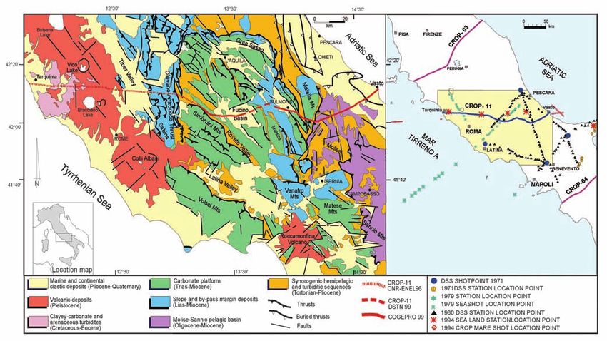
Tyrrhenian region (to the west) is characterized A previous 2D interpretation, based on Bouguer
instead by a young, very active and thinned crust (see and DSS data, shows a possible doubling of the
the afore-mentioned authors and TOZZI et alii, 1992). Moho underneath the Apennines, according to a
One major problem is the involvement of the westward subduction (or passive sinking) of the
basement in the thrust tectonics. In the past, the Adria micro-plate (BERNABINI et alii, 1996). The
Apenninic basement has been interpreted as not authors have assumed a decrease in lateral density in
being involved in the Apennine orogeny. New evi- the lower crust and within the lithospheric mantle of
dence nowadays suggests the opposite: 1) the inter- the Tyrrhenian area (characterized by high heat flow)
pretation of the seismic data (CROP 03, see this (fig. 3). A preliminary 3D reconstruction has also
volume) suggests that the basement was involved been attempted by using the stripping-off technique.
(“wedged Adria”) in the Apenninic orogeny; 2) A strong residual gravity anomaly (-30 mGal), located
recent gravimetric data (DI FILIPPO & TORO, 1993) along the central Apenninic chain, has been detected
indicate the existence of buried steps of the base- between the positive anomalies of both the Adriatic
ment in western areas of the Central Apennines and the Tyrrhenian coasts. There is a fundamental
(e.g. Latina valley); 3) the high degree of shortening difference in the behaviour of the gravity anomalies
of the surface units (CAVINATO et alii, 1994) could be in the northern and southern sectors of the Apenni-
better explained by basement involvement. nes, separated by a sharp E-W trending of the iso-
The cross-sections presented here (fig. 2) have anomalies that is probably related to a NE-SW (W-E)
been reconstructed from surface (bedding, dip- activity of the major faults.
domains, stratigraphic and tectonic contacts) and Interpretation of the gravity data reveals two
subsurface data. The extrapolation of surface geo- main characteristics of the lower crust and upper
metry to depth has been made keeping the relations- mantle in Central Italy. First, the minimum present
hips between tectonic boundaries and bedding con- in the central part of the curve can be modeled by
stant, using the poor seismic data that are available incorporating sub-Moho density differences.148 PAROTTO M. - CAVINATO G.P. - MICCADEI E. - TOZZI M.
Fig. 2 - Schematic cross-sections of the central Apennine thrust belt. A 1) marine and continental deposits (Plio-Quaternary); 2) syn-orogenic depo-
sits (Upper Tortonian-Lower Pliocene); 3) allochthonous deposits (Oligo-Miocene); 4) Umbro-Sabina and Marsica slope and by-pass marginal depo-
sits (Lias-Miocene); 5) Latium-Abruzzi carbonate platform(Lias-Miocene); 6) Adriatic carbonate platform (Lias-Miocene): 7) Triassic car-bonate plat-
form (Trias); 8) magnetic basement (from SALVINI et alii, 1997, modified). B 1) marine and continental post-orogenic sedimentary cover of the
Tyrrhenian side of the Apennines and of the intramontane basins (Upper Messinian-Quaternary) and marine syn- and post-orogenic deposits of
the Adriatic side of the Apennines (Lower Pliocene-Quaternary); 2) syn-orogenic deposits of the different Apennine fore-deep basins (Upper Tor-
tonian to Lower Pliocene); 3) Mt. Circeo tectonic unit; 4) Lepini Mts. tectonic unit; 5) Ernici Mts. and Simbruini Mts. tectonic unit; 6) Marsica tec-
tonic unit; 7) Morrone Mts. and Queglia tectonic unit; 8) Mt. Maiella tectonic unit; 9) Casoli-Bomba tectonic unit; 10) Adriatic foreland; 11) magne-
tic basement of the Apennine thrust belt; 12) magnetic basement of the Adriatic foreland (from CIPOLLARI et alii, 1999).
- Sezioni geologiche schematiche attraverso la catena appenninica dell'Italia centrale. A 1) Depositi marini e continentali (Plio-Quaternario); 2) Depositi sin-orogenici (Torto-
niano sup. - Pliocene inf.); 3) Coltri Alloctone molisane (Oligo-Miocene); 4) Depositi di margine e bacinali Umbro-Sabini e della Marsica (Lias- Miocene); 5) Piattaforma
Laziale-Abruzzese (Lias- Miocene); 6) Piattaforma carbonatica Adriatica (Lias-Miocene); 7) Piattaforma carbonatica Triassica (Trias); 8) Basamento magnetico.(da SAL-
VINI et alii, 1999). B 1) Coperture post-orogene sedimentarie marine e continentali del margine tirrenico, dei bacini intramontani e (Messiniano sup.-Quaternario) e depo-
siti marini sin e post orogeni del margine adriatico (Pliocene inf.-Quaternario); 2) Depositi sin-orogeni dei differenti bacini di avanfossa dell'Appennino (Tortoniano- Plio-
cene inf.); 3) Unità tettonica del M. Circeo; 4) Unità tettonica dei M. Lepini; 5) Unità tettonica dei Simbruini-Ernici; 6) Unità tettonica Marsica; 7) Unità tettonica del
M. Morrone-Queglia; 8) Unità tettonica del M. Maiella; 9) Unità tettonica di Casoli-Bomba; 10) Avampaese Adriatico; 11) Basamento magnetico della catena apen-
ninica; 12) Basamento magnetico dell'avampaese adriatico (da CIPOLLARI et alii, 1999).
This involves a wedge-like body within the thern and Southern Apennines, where strong evi-
upper mantle beneath the core of the Apenninic dence of earthquake hypocenters has revealed sur-
chain having a density similar to that of the lighter faces that are progressively dipping towards the
lower crust. Secondly, keeping the Moho at the Tyrrhenian Sea (AMATO et alii, 1998; PATACCA &
known depth of 20-25 km while following the SCANDONE, 1989 and bibliography inside; GIARDINI
regional trend of the gravity curve requires us to & VELONÀ, 1992). Deep earthquakes are not pre-
decrease the densities of both the lower crust and sent in Central Italy, so the presence of such a slab
the upper mantle on the Tyrrhenian side with (PATACCA & SCANDONE, 1989) is not supported by
respect to the values on the Adriatic side. seismic data. Currently gravimetric data are the
There is a density decrease of the lower crust only deep geophysical data available to support
from the central sector westwards: in the upper this hypothesis.
mantle the parts with differing densities are separa- From the geodynamic point of view, the pre-
ted by a lighter wedge. This model assumes a den- sence of this slab is not just possible, but indeed a
sity of 3.32 g/cm3 for the Adriatic side and 3.26 necessity (DOGLIONI, 1991).
g/cm3 for the Tyrrhenian side. It would correspond to an intermediate crustal
The low-density wedge below the Moho can be domain identified by the deep seismic soundings (in
interpreted as a low-density slab of Adriatic litho- CAVINATO et alii, 1994, according to SCARASCIA et alii,
sphere subducting towards the Tyrrhenian Sea. 1994) (fig. 4). In fact, DSS has identified a doubled
The presence of this slab subducting towards the crustal domain between the Adriatic and the
west has already been hypothesized for the Nor- Tyrrhenian with different physical characteristics.LINE CROP 11: CENTRAL APENNINES 149
Fig. 3 - Simplified gravimetric model along the CROP 11 line, based on 1980 DSS data (Latina-Pescara) (from BERNABINI et alii, 1996, modified).
- Modello gravimetrico semplificato (da BERNABINI et alii, 1996, modificato)
The presence of a lateral dishomogeneity in the for 109 km from Marina di Tarquina to Colli di
lower crust and upper mantle is a feature peculiar to Monte Bove (fig. 1). Starting with our joint work on
this part of the lithosphere. In some other chains a the CROP 04 and CROP 03 acquisition and data
reduction in seismic wave velocity along the Moho processing, our cooperation with the G.A.P. (Acqui-
can be observed along the side towards which the sition and Processing Group), has played an impor-
slab dips. However, gravimetric studies performed tant role in any pre-survey planning. Drawing on its
in Europe (NFP 20, ECORS) generally do not indi- experience in a similar geological setting during the
cate horizontal variations in the upper mantle, first part of CROP 03 (Tuscan units and great
whose density ranges from 3.05 to 3.32 g/cm3 (REY extension of volcanic units), the G.A.P. committee
et alii, 1990; GUALTIERI et alii, 1992). Despite this, the proposed the same acquisition parameters as in
lower densities in the western part of the Italian CROP 03 (dynamite energy source, symmetric split-
peninsula with respect to the eastern side can be spread) from Marina di Tarquinia to the Tiber River
justified by the values of heat flow and the sprea- (fig. 5). Before reaching the Tiber River, and once
ding of the Tyrrhenian Sea. the profile had passed across the Sabina thrust belt,
the G.A.P. proposed a change in the group interval
from 60 to 40 m.
4. - SEISMIC ACQUISITION Data acquisition was performed by the “Osser-
vatorio Geofisico Sperimentale”, now known as the
The seismic profile CROP 11 was acquired “Istituto Nazionale di Oceanografia e di Geofisica
from the Tyrrhenian Sea (Marina di Tarquinia) to Sperimentale” (O.G.S.-Trieste), with an accurate
the Adriatic Sea (Vasto) for a length of 265 km quality control applied in the field through the
(fig. 1). In 1989 the CROP 11 working group installation of a micro-processing centre under the
began drawning up the preliminary trace of the close supervision of the G.A.P. (fig. 6).
seismic line, integrating it with CROP surveys and Acquisition was suspended for three years due
analyses (structural and stratigraphic). In 1991 the to a lack of funds and was completed at the end of
proposed trace and the scientific data were discus- 1999. The 156 km of the second part of the profi-
sed in a Meeting (TOZZI et alii, 1992). le were jointly financed by CNR and ENEL (7 km
The profile was acquired in two different 1996 with residual financial funds), the Dipartimen-
periods. The first part started in 1996 and was run to Servizi Tecnici Nazionali (D.S.T.N.) (37 km, from150 PAROTTO M. - CAVINATO G.P. - MICCADEI E. - TOZZI M.
Fig. 4 - Crustal section along the CROP 11 line based on DSS data. 1) Aeromagnetic basement; 2) crustal low-velocity layer; 3) lower crust; 4) Moho
(from BERNABINI et alii, 1996, modified).
Sezione geologica crostale lungo la traccia del profilo CROP 11 basata su dati DSS. 1) Basamento aeromagne-tico; 2) Intervallo crostale a bassa velocità; 3) Crosta inferiore;
4) Moho (da BERNABINI et alii, 1996, modificata)
Corcumello to Prezza) and by CO.GE.PRO. (Con- gration of the seismic data with the surface geology
sorzio Geofisica Profonda) a consortium between and subsurface information derived from several
the O.G.S. and GEOTEC for the 112 km from wells drilled in the region for petroleum explora-
Prezza to Vasto (fig. 1). tion. Company lines and data have contributed to
The data acquired are generally of good quality, improving the reconstruction converted by means
in particular from the Tiber Valley across the Apen- of GeoSec software, using velocity values that were
ninic chain to the Fucino basin, although there is obtained from borehole calibrations on the line, as
some variability due to the different shallow litholo- well as from subsurface regional information.
gies and surface structural trends and different local Between Mt. Maiella and the Adriatic shoreline,
noise conditions. the CROP 11 line cuts across the outer margin of
The processing was carried out at the O.G.S. the Apennine thrust belt and the inner margin of
seismic processing centre by L. Cernobori. The pro- the Apulia foreland.
cessing sequence is that normally used for on-shore The portion of Apulia foreland explored by
data processing, although it focuses on the specific commercial boreholes consists of a thick pile (more
targets of the project; thus, the processing parame- than 6000 m) of Mesozoic-Tertiary shallow-water
ters were chosen so as to highlight deep geological carbonates (as well as Triassic evaporites) confor-
structures without neglecting those near the surface mably overlying Permian-Triassic siliciclastic depo-
(BERTELLI et alii, this volume). sits (see Puglia 1 and Gargano 1 wells) and discon-
During the 1995 CROP off-shore acquisition, in formably overlain by Pliocene-Pleistocene clays,
collaboration with the CNR (Istituto Rischio Sismi- sands and subordinate conglomerates. Messinian
co, Milano) the seismic signals were acquired in evaporites commonly occur on top of the Meso-
several stations along the trace of CROP 11 (BIEL- zoic-Tertiary carbonates. Due to the acoustic-impe-
LA et alii, 1997). This data permit to confirm that the dance contrast, a continuous strong reflector gene-
Tyrrhenian crustal tickness is about 22 km and in rally marks the top of the Apulia carbonates
the eastern part (from Vasto to Maiella) the adriatic (including the Messinian evaporites). Between 4 and
crust is 35 km thick. 5 seconds TWT, a sudden change occurs in the sei-
smic facies. A layered unit characterized by a packa-
ge of well-defined continuous reflectors underlies
5. - PRELIMINARY RESULTS the massive unit of the platform carbonates that
shows only discontinuous irregular reflectors. This
The interpretation of the lines started in the change marks the contact between the Middle-
middle of 2001 with the easternmost part, from Upper Triassic dolomites and anhydrites and the
Vasto to Maiella. The preliminary results were pre- Permian-Lower Triassic Verrucano-like siliciclastic
sented at the GNGTS Congress (BILLI et alii, 2001) deposits.
and are summarized here. In the Furci-Scerni area, the Pliocene-Pleisto-
Identification of the main reflectors recognized cene autochthonous deposits disconformably
between 0 and 5 seconds TWT is based on the inte- covering the Apulia carbonates and evaporites areLINE CROP 11: CENTRAL APENNINES 151
Fig. 5 - Photo gallery of the CROP 11 acquisition phase. A) Tarquinia area; B) Colli di Monte Bove area; C) Tagliacozzo-Fucino area;
D) Fucino area.
- Galleria fotografica della linea CROP 11. A) Zona di Tarquinia; B) Colli di Monte Bove; C) Zona di Tagliacozzo-Fucino; D) Area del Fucino.
tectonically overlain by rootless nappes (Molise the Bomba area. West of the Bomba structure, the
units). The allochthonous sheets basically consist top of the platform rapidly deepens to about 2.5
of Middle Cretaceous-Upper Miocene basinal car- seconds TWT. In this area, the Torricella Peligna 2
bonates followed by uppermost Tortonian-Lower well bottomholed at 2472 m (1697 m below sea
Messinian siliciclastic flysch deposits. In the study level) without reaching the Apulia platform. Fur-
region, the Molise nappes are unconformably ther west, the top of the Apulia platform rises
overlain by Upper Messinian to Lower Pleistocene rapidly to shallower levels and finally reaches the
thrust-sheet-top deposits. surface in correspondence to the eastern flank of
From the Adriatic coast to the eastern margin Mt. Maiella.
of the Frentani Mountains, the top of the foreland The deepening of the Apulia carbonates from
Apulia carbonates for about 25 kilometres takes Mt. Maiella to the Torricella Peligna structural
the shape of a regular homocline gently dipping depression has been interpreted as the expression
towards the west. The top of the carbonates lies at of a thrust-fold cascade, that is, of a stack of
about 1.8 seconds TWT in the east and 2 seconds partly overlapping ramp anticlines, derived from
in the west. Moving westwards from the eastern at least three imbricates the highest of which is
foot of the Frentani mountains, the structural set- represented by the Maiella anticline. The subse-
ting of the Apulia carbonates provides evidence quent rise of the Apulia carbonates from the Tor-
for a severe compressional deformation. The top ricella Peligna depression to the Bomba ridge has
of the platform climbs from 2 seconds east of been interpreted as a first-order back-thrust featu-
Pennadomo 1 to about 1 seconds (i.e., less than re related to a triangle zone at the base of the plat-
1000 metres below sea level) in correspondence to form that in late Pliocene-early Pleistocene times152 PAROTTO M. - CAVINATO G.P. - MICCADEI E. - TOZZI M.
Fig. 6 - The G.A.P and CROP 11 working group at Celano (AQ) during the acquisition of CROP 11.
- Il G.A.P. e il working group del CROP 11 a Celano (Aq) durante le fasi di acquisizione della linea CROP 11.
allowed tectonic transport to take place from a Acknowledgements
hinterland-dipping thrust-flat surface (sole thrust
of the Apenninic system) to a foreland-dipping The authors would like to thank all members of the CROP
11 working group who have participated in the preliminary and
ramp. Other authors have recently interpreted the acquisition phase over the years (CARUSI C., CORRADO S.,
western flank of the Bomba ridge as the footwall CRESCENZI B., DE CORSO S., DE ROSA G., DI BUCCI D.,
of a normal-fault system responsible for the dee- DI LUZIO E., SAROLI M., VECCHIA P.) Thanks are extended in
particular to L. CERNOBORI, who was the main contributor to the
pening of the Apulia carbonates in the Torricella processing analysis.
Peligna area.
The deep crustal structures in the area crossed
by the CROP 11 are well imaged in corresponden-
ce to the Apulian foreland. A reflector is recognised
at around 7 s TWT, gently dipping towards the west. REFERENCES
It can be easily followed up to the Bomba ridge area
where there are complex structures and velocity
AMATO A., MARGHERITI L., AZZARA R. BASILI A., CHIARABBA C.,
changes near the surface and at depth. Other deeper CIACCIO M.G., CIMINI G. B., DI BONA M., FREPOLI A.,
and sub-parallel reflective intervals are imaged at 10 LUCENTE F.P., NOSTRO C. & SELVAGGI G. (1998) – Passive
s and at 12 s TWT. These can be assigned to a laye- Seismology and Deep Structure in Central Italy. Pure App. Geo-
phys., 151: 479-493.
red lower crust of about 2.5 s thickness (about 9
km). The Moho can be identified at the base of the ARISI ROTA F. & FICHERA R. (1987) - Magnetic interpretation relat-
ed to geomagnetic provinces: the Italian case history. Tectono-
lowermost interval, at 12.5 s reflection time (around physics, 138: 179-196.
32 km depth). This discontinuity deepens towards BALLY A.W., BURBI C., COOPER C. & GHELARDONI R. (1986) -
the west and reaches 13 to 14 s TWT beneath Mt. Balanced cross sections and seismic reflection profiles across the Cen-
Maiella. tral Apennines. Mem. Soc. Geol. It., 35: 257-310.LINE CROP 11: CENTRAL APENNINES 153
BERNABINI M., DI BUCCI D., ORLANDO L., PAROTTO M. & TOZZI GIARDINI D. & VELONÀ M. (1992) - La sismicità profonda del Mar
M. (1996) - Gravimetric evidence of deep structure in mountain Tirreno. Mem. Soc. Geol. It., 41: 1079-1086.
building: subducted Adriatic crust beneath the Tyrrhenian Moho in
Central Italy. J. Geodynam., 21: 223-234. GUALTERI L., VALENTI L. & CASSINIS R. (1992) - Modelling gravimet-
rico e magnetico nella regione di transizione tra la Liguria orientale e la
BIGI G., COSENTINO D., PAROTTO M., SARTORI, R. & SCANDONE Toscana. Studi Geologici Camerti vol. spec. 1992/2, 107-114.
P. (1992) - Structural Model of Italy. Scale 1:500,000.
Quaderni de “La Ricerca Scientifica”, CNR, 114 (3). HOOKER P. J., BERTRAMI R., LOMBARDI S., O’NIONS R. K. &
OXBURGH E. R. (1985) - Helium-3 anomalies and crust-mantle
BIELLA G., CAVINATO G.P., DE FRANCO R., PAROTTO M. & TOZZI interaction in Italy. Geochim. Cosmochim. Acta, 49: 2505-
M. (1997) - Assetto tettonico e struttura crostale dell’Italia centrale 2513.
lungo il profilo CROP 11. Atti Convegno CROP-MARE,
Trieste 23-24 Giugno 1997. MORELLI C. (1975) - Gravimetry of Italy. In: OGNIBEN L. et alii
(Eds.): “Structural Model of Italy”. Quaderni de “La Ricerca
BILLI A., CAVINATO G.P., CERNOBORI L., DI LUZIO E., NICOLICH R., Scientifica”, CNR: 90.
PAROTTO M., PATACCA E., PERSOGLIA S., SCANDONE P., SCROC-
CA D. & TOZZI M. (2001) – Preliminary interpretation of the Crop MOSTARDINI, F. & MERLINI, S. (1986) - Appennino centro-merid-
11 seismic line from the Maiella area to the Adriatic coast. Atti XX ionale, sezioni geologiche e proposta di modello strutturale. Mem.
Convegno Nazionale GNGTS,CNR- Roma: 137-138. Soc. Geol. It., 35: 342-361.
CARROZZO M. T., LUZIO D., MARGIOTTA C. & QUARTA, T. (1992) NICOLICH R. (1989) - Crustal structures from seismic studies in the
- Gravity Map of Italy. Scala 1:500,000.Quaderni de “La frame of the European Geotraverse (southern segment) and CROP
Ricerca Scientifica”, CNR 114, (3). projects. In: BORIANI A., BONAFEDE M., PICCARDO G.B. &
VAL G.B. (Eds): “The Lithosphere in Italy”. Atti Convegni
CAVINATO G.P. & DE CELLES P.G. (1999) - Extensional basins in Lincei, 80: 41-61.
the tectonically bimodal central Apennines fold-thrust belt, Italy:
response to corner flow above a subducting slab in retrograde motion. PATACCA E. & SCANDONE P. (1989) – Post-Tortonian Moutain
Geology, 27 (10): 955-958. building in the Apennines. The role of the passive sinking of a relic
lithospheric slab. In: BORIANI A., BONAFEDE M., PICCARDO
CAVINATO G. P., COSENTINO D., FUNICIELLO R., PAROTTO M., G.B. & VAI G. B. (Eds.): “The lithosphere in Italy”. Atti Con-
SALVINI F. & TOZZI M. (1994) - Constraints and new problems vegni Lincei. 80: 157-176.
for a geodynamical modelling of central Italy (CROP 11 Civitavec-
chia-Vasto deep seismic line). Boll. Geof. Teor. Appl., 36 (141- PATACCA E., SARTORI R. & SCANDONE P. (1990) - Tyrrhenian basin
144): 159-174. and Apenninic arcs: kinematic relations since Late Tortonian times.
Mem. Soc. Geol. It., 45: 425-451.
CIPOLLARI P. & COSENTINO D. (1997) - Il sistema Tirreno-Appen-
nino: segmentazione litosferica e propagazione del fronte appennini- PATACCA E., SCANDONE P., PERILLI N., & SANTINI U. (1992) - La
co. Studi Geologici Camerti, vol. spec., 1995/2: 125-134. zona di giunzione tra l’arco appenninico settentrionale e l’arco
appenninico meridionale nell’Abruzzo e nel Molise. Studi Geol.
CIPOLLARI, P., COSENTINO D. & PAROTTO M. (1997) - Modello cin- Camerti, Spec. Vol. 1991/2: 417-441.
ematico-strutturale dell’Italia centrale. Studi Geol. Camerti,
spec. vol., 1995/2: 135-143. REY D., QUARTA T., MOUGE P., MILETTO M., LANZA R.,
GALDEANO A., CAROZZO M.T., ARMANDO E. & BAYER R.
CIPOLLARI P., COSENTINO D., ESU D., GIROTTI O., GLIOZZI E. & (1990) - Gravity and aeromagnetic maps on the western Alps: con-
PRATURLON A. (1999) - Thrust-top lacustrine–lagoonal basin tribution to the knowledge on the deep structures along the
development in accretionary wedges: late Messinian (Lago-Mare) Ecors-Crop seismic profile. In: ROURE F., HEITZMANN P. &
episode in the central Apennines (Italy). Palaeogeogr., Palaeo- Polino R. (Eds): “Deep Structure of the Alps.” Mém. Soc.
clim., Palaeoecol. 151: 149–166. Géol. Fr., 156: 107-121.
DELLA VEDOVA B., MARJON J., PANZA G. F. & SUHADOLC P. ROYDEN L., PATACCA E. & SCANDONE P. (1987) - Segmentation and
(1988) - Upper mantle properties along a profile intersecting EGT configuration of subducted lithosphere in Italy: an important control on
(Corsica - Istria). Abstr. XIII EGS Gen. Ass., Bologna. thrust belt and foredeep basin evolution. Geology, 15: 714-717.
DI FILIPPO M. & TORO B. (1993) - Gravimetric Study of Sabatini SALVINI F., CAVINATO G.P., CIPOLLARI P., CORRADO S., COSENTI-
Area. In: DI FILIPPO M. (Ed.): “Sabatini Volcanic Complex”. NO D., DI BUCCI D., MICCADEI E., NASO G., PAROTTO M.,
Quaderni de “la Ricerca Scientifica”, CNR: 114, (11): 95-99. PRATURLON A., STORTI F. & TOZZI M. (1997) - Structural
DOGLIONI C. (1991) - A proposal for the kinematic modelling of W- styles of the Apennines, Central Italy. Am. Ass. Petrol. Geol.
dipping subductions. Possible applications to the Tyrrhenian-Apen- Bull., 81: 1409.
nines system. Terra Nova, 5: 423-434. SCARASCIA S., LOZEJ A. & CASSINIS R. (1994) - Crustal structures
FEDI M. & RAPOLLA A. (1992) - La regione appenninica meridionale: of the Ligurian, Tyrrhenian and Ionian Seas and adjacent onshore
struttura crostale e aspetti geodinamici da dati gravimetrici e mag- areas interpreted from wide-angle seismic profile. Boll. Geof. Teor.
netici. Mem. Soc. Geol. It., 41: 1291-1297. Applicata, 36 (141-144): 5-19.
GHISETTI F. & VEZZANI L. (1997) - Interfering paths of deformation TOZZI M., CAVINATO G. P. & PAROTTO M. (Eds.) (1992) - Studi
and development of arcs in the fold -and-thrust belt of central preliminari all’acquisizione del profilo CROP 11 Civitavecchia -
Apennines (Italy). Tectonics, 16: 523-536. Vasto. Studi Geologici Camerti, vol. spec., 1991/2: 441.You can also read