Lake Macquarie Development Control Plan 2014 - Revision 27 Part 4 - Development in Business Zones
←
→
Page content transcription
If your browser does not render page correctly, please read the page content below
Part 4 – Development in Business Zones

         Lake Macquarie Development Control Plan 2014
                                       – Revision 27

                                   Part 4 – Development in Business Zones

                                                       Adopted 9 August 2021

LMCC DCP 2014 – Revision 27
Page 0 – F2020/01024
Adopted by Council 9 August 2021
Part 4 – Development in Business Zones Table of Contents: 1 INTRODUCTION ................................................................................................................................. 4 1.1 HOW TO USE THIS PLAN.................................................................................................................... 4 1.2 ADDITIONAL CONTROLS FOR SPECIFIC LAND USES .................................................................... 5 1.3 AIMS FOR DEVELOPMENT IN BUSINESS ZONES ........................................................................... 5 1.4 B3 COMMERCIAL CORE ..................................................................................................................... 6 1.5 B2 LOCAL CENTRES ........................................................................................................................... 6 1.6 B1 NEIGHBOURHOOD CENTRES ...................................................................................................... 6 1.7 B4 MIXED USE ZONE .......................................................................................................................... 6 2 CONTEXT AND SETTING .................................................................................................................. 7 2.1 SITE ANALYSIS .................................................................................................................................... 7 2.2 SCENIC VALUES .................................................................................................................................. 7 2.3 GEOTECHNICAL .................................................................................................................................. 9 2.4 CUT AND FILL ...................................................................................................................................... 9 2.5 MINE SUBSIDENCE ............................................................................................................................. 9 2.6 CONTAMINATED LAND ..................................................................................................................... 10 2.7 ACID SULFATE SOILS ....................................................................................................................... 11 2.8 STORMWATER MANAGEMENT........................................................................................................ 11 2.9 CATCHMENT FLOOD MANAGEMENT ............................................................................................. 12 2.10 LAKE FLOODING AND TIDAL INUNDATION (INCORPORATING SEA LEVEL RISE) ....................15 2.11 NATURAL WATER SYSTEMS ........................................................................................................... 18 2.12 BUSHFIRE .......................................................................................................................................... 20 2.13 FLORA AND FAUNA ........................................................................................................................... 20 2.14 PRESERVATION OF TREES AND VEGETATION ............................................................................ 22 2.15 EUROPEAN HERITAGE ..................................................................................................................... 24 2.16 ABORIGINAL HERITAGE ................................................................................................................... 25 2.17 NATURAL HERITAGE ........................................................................................................................ 27 2.18 SOCIAL IMPACT ................................................................................................................................. 27 2.19 ECONOMIC IMPACT .......................................................................................................................... 29 2.20 LOT AMALGAMATION ....................................................................................................................... 30 2.21 UTILITY INFRASTRUCTURE ............................................................................................................. 30 2.22 SITES WHERE A CONCEPT PLAN IS REQUIRED........................................................................... 31 3 STREETS AND PUBLIC SPACE ...................................................................................................... 32 3.1 PEDESTRIAN LANES ......................................................................................................................... 32 3.2 PEDESTRIAN LINKS THROUGH BUILDINGS .................................................................................. 32 3.3 FOOTPATH DINING ........................................................................................................................... 33 3.4 STREETSCAPE IMPROVEMENTS .................................................................................................... 34 3.5 NON-DISCRIMINATORY ACCESS .................................................................................................... 34 3.6 LIGHTING............................................................................................................................................ 35 4 ACTIVE STREET FRONTAGE ......................................................................................................... 36 4.1 GROUND FLOOR RESIDENTIAL USES IN THE BUSINESS ZONES ..............................................36 4.2 GROUND FLOOR LEVELS ................................................................................................................ 36 4.3 GROUND FLOOR ENTRIES .............................................................................................................. 37 4.4 GROUND FLOOR GLAZING .............................................................................................................. 38 4.5 STREET AWNINGS ............................................................................................................................ 38 5 ACCESS AND PARKING .................................................................................................................. 40 LMCC DCP 2014 – Revision 27 Page 1 – F2020/01024 Adopted by Council 9 August 2021
Part 4 – Development in Business Zones

5.1     TRAFFIC AND VEHICLE ACCESS .................................................................................................... 40
5.2     DESIGN OF PARKING AND SERVICE AREAS................................................................................. 40
5.3     BIKE PARKING AND FACILITIES ...................................................................................................... 41
5.4     MOTOR BIKE PARKING..................................................................................................................... 42
5.5     CAR PARKING RATES....................................................................................................................... 42
6        DEVELOPMENT DESIGN ................................................................................................................ 49
6.1     FRONT SETBACKS – SHOPPING CENTRES IN B1 AND B2 ZONES .............................................49
6.2     FRONT SETBACKS – MAIN STREET SHOPS IN B1 B2 AND B3 ZONES .......................................49
6.3     FRONT SETBACKS - B4 ZONE ......................................................................................................... 50
6.4     FAÇADE ARTICULATION .................................................................................................................. 51
6.5     BUILDING EXTERIORS ...................................................................................................................... 51
6.6     BUILDING SEPARATION ................................................................................................................... 52
6.7     SIDE AND REAR SETBACKS ............................................................................................................ 52
6.8     MINIMUM LANDSCAPED AREA ........................................................................................................ 53
6.9     BUILDING DEPTH .............................................................................................................................. 54
6.10    MAXIMUM OCCUPIED AREA ............................................................................................................ 54
6.11    SETBACKS FROM RESIDENTIAL ZONED LAND............................................................................. 54
6.12    BUILDING HEIGHT ............................................................................................................................. 55
6.13    BUILDING HEIGHT AT THE STREET ................................................................................................ 56
6.14    FLOOR TO CEILING HEIGHTS.......................................................................................................... 56
6.15    ROOFS ................................................................................................................................................ 57
6.16    VIEWS ................................................................................................................................................. 57
6.17    BALCONIES AND COMMUNAL OPEN SPACE................................................................................. 57
6.18    PLANTING ON STRUCTURES .......................................................................................................... 58
6.19    SOLAR ACCESS AND ORIENTATION .............................................................................................. 58
6.20    ENERGY EFFICIENCY AND GENERATION ..................................................................................... 59
6.21    VISUAL PRIVACY ............................................................................................................................... 59
6.22    ACOUSTIC PRIVACY ......................................................................................................................... 60
6.23    FRONT FENCES ................................................................................................................................ 60
6.24    SIDE AND REAR FENCES ................................................................................................................. 60
6.25    SAFETY AND SECURITY................................................................................................................... 61
7        LANDSCAPE ..................................................................................................................................... 63
7.1     LANDSCAPE DESIGN ........................................................................................................................ 63
7.2     STREET TREES AND STREETSCAPE IMPROVEMENTS............................................................... 64
7.3     LANDSCAPE AND TREE PLANTING IN FRONT SETBACK AREAS ...............................................64
7.4     LANDSCAPE AND TREE PLANTING IN CAR PARKS ...................................................................... 65
8        OPERATIONAL REQUIREMENTS................................................................................................... 66
8.1     DEMOLITION AND CONSTRUCTION WASTE MANAGEMENT ......................................................66
8.2     operational WASTE MANAGEMENT .................................................................................................. 67
8.3     ON-SITE SEWAGE MANAGEMENT .................................................................................................. 68
8.4     LIQUID TRADE WASTE AND CHEMICAL STORAGE ...................................................................... 69
8.5     EROSION AND SEDIMENT CONTROL ............................................................................................. 69
8.6     AIR QUALITY ...................................................................................................................................... 70
8.7     NOISE AND VIBRATION .................................................................................................................... 70

LMCC DCP 2014 – Revision 27
Page 2 – F2020/01024
Adopted by Council 9 August 2021
Part 4 – Development in Business Zones
LIST OF TABLES
Table 1 - Development requiring a landscape and visual impact assessment.......................................... 8
Table 2 - Flood Planning Levels and floor height requirements in areas affected by catchment flooding
and covered by a Floodplain Management Study and Plan..................................................... 13
Table 3 - Floor height requirements for land affected by Lake Flooding and Tidal Inundation
requirements. ............................................................................................................................ 17
Table 4 - Excluded Development Criteria for Development in Sensitive Aboriginal Landscape Map ..... 26
Table 5 - Uses requiring Social Impact Assessment ............................................................................... 28
Table 6 - Development types requiring a Disability Access Audit ........................................................... 35
Table 7 - Car Parking Rates for Development in Business Zones .......................................................... 44
Table 8 - Setbacks from residential zoned land ...................................................................................... 55
Table 9 - Maximum number of storeys .................................................................................................... 55
Table 10 - Minimum floor to ceiling heights ............................................................................................... 56
Table 11 - Uses requiring a crime risk assessment................................................................................... 62
Table 12 - Landscape development type and requirements. .................................................................... 63
Table 13 - Uses requiring an Operational Waste Management Plan ........................................................ 67
LIST OF FIGURES:
Figure 1 - Vegetated Riparian Zones ........................................................................................................ 19
Figure 2 - Location of Footpath Dining...................................................................................................... 33
Figure 3 - Level change between footpath and ground floor level ............................................................ 37
Figure 4 - Floor levels and roof levels stepping with topography ............................................................. 38
Figure 5 - Cantilever box awnings and street trees .................................................................................. 39
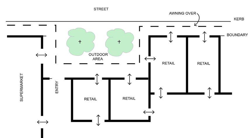
Figure 6 - Outdoor trading area at entry to a stand alone shopping centre .............................................. 49
Figure 7 - Building setbacks and building depth for development in B1 B2 B3 zones ............................. 50
Figure 8 - Setbacks and building depths for development in B4 zone ..................................................... 50
Figure 9 - Building to the side boundary ................................................................................................... 53
Figure 10 - Example of building mass that achieves 50% occupied area on upper levels at the rear
of the development ................................................................................................................... 54
Figure 11 - Example of height allowed for three storey building ................................................................. 56
LMCC DCP 2014 – Revision 27
Page 3 – F2020/01024
Adopted by Council 9 August 2021Part 4 – Development in Business Zones
1 INTRODUCTION
Part 4 - Development in Business Zones applies to all development in the B1 Neighbourhood Centre, B2
Local Centre, B3 Commercial Core, and in B4 Mixed Use zones.
This part is to be read in conjunction with Part 1 (Introduction) of DCP 2014, which outlines Council’s general
requirements for all developments and provides advice on the lodgement requirements for a Development
Application. Part 1 also contains requirements for when an application seeks to vary a development control.
Additionally, controls for specific land uses may apply depending on the type of development proposed.
They can be found within Part 9 of this DCP.
Furthermore, an Area Plan may apply depending on the location of the development. Area Plans contain
area specific controls that need to be considered and can be found in Parts 10, 11 and 12 of this DCP.
For mixed-use development, any building that includes four or more dwellings and is three or more storeys in
height must comply with the provisions of Part 9: Residential Flat Buildings, as well as the provisions of
SEPP 65– Design Quality of Residential Flat Development and Residential Flat Design Code.
1.1 HOW TO USE THIS PLAN
LM DCP 2014 is the primary document used by Council’s development assessment staff to assess
development applications. Proponents of development will need to:
1. Determine the land use zone that applies to the development site (refer to LM LEP 2014);
2. Refer to the Part of LM DCP 2014 that contains controls for the zone where the development is
proposed (Parts 2 to 8);
3. Check if specific land use provisions apply to the proposed development (Part 9); and
4. Check if an Area Plan applies to the proposed development site (Parts 10, 11 or 12).
The development controls contained within each part and section, seek to achieve desired land use,
conservation and/or built outcomes consistent with corresponding LM LEP 2014 zone objectives and aims in
each part of LM DCP 2014.
Each part of this DCP is structured to promote a development process where the site and context analysis
informs the design of the development. This part of the DCP has the following main headings:
• Introduction – provides information about the particular part of the DCP, how to use the DCP and
aims for development within the particular zone.
• Context and Setting – outlines the site issues and environmental opportunities and constraints that
need to be addressed in the development application.
• Streets and Public Space – outlines the public domain considerations that need to be addressed in
a development application.
• Active Street Frontage – outlines the specific requirements of how the building interacts with the
street.
• Access and Parking – outlines the pedestrian and vehicular access issues that need to be
addressed in the development application.
• Development Design – provides Council’s detailed site-specific building design related
requirements.
• Landscape Design – provides Council’s detailed landscape design requirements.
• Operational Requirements – provides Council’s detailed requirements associated with the
construction and ongoing operation of the development.
The detailed provisions of each subsection in each part of LM DCP 2014 are presented as follows:
LMCC DCP 2014 – Revision 27
Page 4 – F2020/01024
Adopted by Council 9 August 2021Part 4 – Development in Business Zones
• Objectives – state what outcomes Lake Macquarie City Council is seeking new development to
achieve, and
• Controls – advise the requirements for achieving outcomes and the desired future character
identified by the aims and objectives.
Additionally, Parts 2 to 8 contain the specific aims, which LM DCP 2014 seeks to achieve.
For more information on how to use this document, please consult Part 1 – Introduction.
1.2 ADDITIONAL CONTROLS FOR SPECIFIC LAND USES
If the development application relates to any of the following land uses, additional specific development
controls must be considered in conjunction with controls in this part of the DCP. The detailed controls for
these uses can be found in Part 9 of LM DCP 2014. Where a conflict exists between the controls within this
part and a specific land use, the specific land use section prevails.
Bed & Breakfast/Farm stay Accommodation Residential Flat Buildings
Child Care Centres Service Stations
Foreshore and Waterway Development Sex Services Premises
Health Consulting Rooms Signage
Home Business and Industry Tourist and Visitor Accommodation
Places of Public Worship
1.3 AIMS FOR DEVELOPMENT IN BUSINESS ZONES
Where controls are not provided for a particular circumstance, the following aims will be used to provide
direction for a merits based assessment of a development application.
The aims of LM DCP 2014 for development in business zones are:
1. To support the business centres hierarchy contained in the Lifestyle 2030 Strategy.
2. To support retail, business, entertainment and community uses that contribute to safe and vibrant places
for people who live in, work in and visit the centre.
3. To provide for appropriate employment opportunities in accessible locations, and for housing within
mixed use developments.
4. To maximise public transport patronage and encourage walking and cycling.
5. To make efficient use of land through the amalgamation of existing lots to facilitate higher yields and
good built form, and to avoid unnecessary isolation of lots.
6. To encourage Ecologically Sustainable Design principles to reduce energy, materials and water
consumption.
LMCC DCP 2014 – Revision 27
Page 5 – F2020/01024
Adopted by Council 9 August 2021Part 4 – Development in Business Zones
1.4 B3 COMMERCIAL CORE
Charlestown, Glendale and Morisset
The B3 Commercial Core Zone is intended to provide the greatest concentration of commercial floor space,
services and facilities for the wider community. The core activities in this zone are commercial and retail,
supported by government services, with residential, community, recreational, educational, entertainment,
tourist and open space uses.
Preferred land uses are retail premises, business premises, food and drink premises, entertainment facilities,
and office premises at street level with office premises, tourist accommodation or apartments above.
See Charlestown Major Regional Centre Area Plan and Morisset Town Centre Area Plan for additional
background and controls.
1.5 B2 LOCAL CENTRES
Swansea, Belmont, Warners Bay, Toronto, Mount Hutton and Cameron Park/Pambulong.
The B2 Local Centre Zone is intended to provide a range of retail, business, office, entertainment,
community and other suitable land uses that serve the needs of the local community.
Preferred land uses are retail premises, business premises, and food and drink premises. Also preferred are
office premises at street level with office premises, tourist accommodation or apartments above.
See Belmont Town Centre Area Plan, Warners Bay Town Centre Area Plan, Toronto Town Centre Area Plan
and Mount Hutton Centre Area Plan for additional background and controls.
1.6 B1 NEIGHBOURHOOD CENTRES
B1 Neighbourhood Centres include, Kahibah, Whitebridge, Dudley, Redhead, Windale, Jewells, Boolaroo,
Northlakes, West Wallsend, Teralba, Woodrising, Bonnells Bay, Wangi Wangi and Wyee Point
The B1 Neighbourhood Centre Zone is intended to provide a limited range of small-scale retail, business and
community uses that serve the needs of people who live or work in the surrounding neighbourhood.
Preferred land uses are small retail premises, food and drink premises, and smaller office premises at street
level with office premises or housing above.
1.7 B4 MIXED USE ZONE
The B4 Mixed Use Zone is intended to complement and enhance the activity of the local and regional
centres, and to serve as a transition between the centre and surrounding residential zones.
B4 areas are located at Charlestown, Glendale, Cardiff, Belmont, Mount Hutton, Warners Bay, Swansea,
Toronto, Morisset, Cooranbong, Argenton, Cockle Creek, Wangi Wangi, Belmont North and Caves Beach.
The preferred mix of land uses is either business or office premises, retail premises, or food and drink
premises at street level, with office premises, shop-top housing or apartments above. Activity in the centre
should be supported by development of community, recreational, educational, entertainment, tourist and
open space facilities.
Img_002
LMCC DCP 2014 – Revision 27
Page 6 – F2020/01024
Adopted by Council 9 August 2021Part 4 – Development in Business Zones
2 CONTEXT AND SETTING
2.1 SITE ANALYSIS
Objectives
a. To encourage good site planning, built form and landscape outcomes informed by an
understanding of the site and its context.
b. To illustrate how a development responds to a site and its relationship with the locality.
c. To identify the opportunities and constraints of sites, and the prevailing characteristics of a locality.
Controls
1. A Site Analysis Plan must be submitted that identifies the existing conditions relating to the subject
site and the surrounding land that may influence the design outcome.
2. The Site Analysis Plan must address:
i. all relevant items as set out in the Site Analysis Guidelines, and
ii. all relevant matters outlined below in section 2.2 to 2.22.
3. The Site Analysis Plan must provide a comprehensive view of the constraints and opportunities of
the development site that will guide the design process.
4. The development application must clearly show that the constraints and opportunities identified in
the Site Analysis Plan have been used to inform and resolve the development design.
5. An electronic 3D block model must be submitted for any development that is three or more storeys,
or that has a Gross Floor Area of 2000m2 or more. The model must clearly show the scale and
form of the proposed development and its setting, from viewing points along the street, and from
public open space, waterways and other significant vantage points.
6. Council may require an electronic model for smaller developments on sites with potentially high
visual or physical impacts on the public realm.
Note: The detail of the Site Analysis Plan should be tailored to the site, and the complexity of the proposed
development.
2.2 SCENIC VALUES
The Landscape Settings and Significant Natural Landscape Features Maps identify the Landscape
Setting boundaries and the relevant Scenic Management Zone for each Landscape Setting. The maps are a
guide to the scenic quality associated with lands within the City of Lake Macquarie and are contained within
the Scenic Management Guidelines. The Scenic Management Guidelines provide supporting documentation
to this DCP.
Objectives:
a. To ensure that the scenic values of the City are protected and enhanced.
b. To ensure that developments visible or adjoining the coastline, Lake Macquarie or ridgelines
maintain and enhance the scenic value of these features.
Controls:
1. A landscape and visual impact assessment is required for development identified in Table 1 unless
specified by Council. A landscape and visual impact assessment must be prepared in accordance
with section 7.3 of the Scenic Management Guidelines.
LMCC DCP 2014 – Revision 27
Page 7 – F2020/01024
Adopted by Council 9 August 2021Part 4 – Development in Business Zones
Table 1 - Development requiring a landscape and visual impact assessment
Type, category or impact of development:
• Any designated, SEPP 14 or SEPP 65 development
• Any new development or alterations and additions resulting in a building or structure equivalent to 4
storeys or more (in any zone), or a car park of 2 or more storeys (in any zone)
• Telecommunication towers
• Substantial loss of native tree cover (land parcels of one hectare or greater)
• Subdivisions (in any zone with 10 or more lots proposed)
• Tourist and visitor accommodation
• Waste or resource management facilities
• Recreation facilities (major)
• Service stations
• Removal of any tree on the Significant Tree Register
• Seniors living developments and hospitals with more than 30 beds
• Educational facilities
• Any commercial buildings being more than 50 metres long on any side, or being over 10 metres
high
Location of development:
• Any development that is; within 300m of the Mean High Water Mark of the lake or coastal edge, or
on a ridgeline and involves two or more of the following:
o height equivalent to 3 or more storeys, or
o sloping site (10% or more), or
o requiring a combined cut and fill exceeding 2 metres, or
o a development footprint exceeding 2000m2.
• Any building or structure in a public reserve having a footprint exceeding 100m2 or being over 10
metres high.
• Any development on a heritage item and/or development within a heritage conservation area (apart
from alterations and additions to existing houses or new complying development houses)
• Any development within 300m of the Sydney-Newcastle Freeway (apart from alterations and
additions to existing houses or new complying development houses)
2. Developments must be designed and sited to complement their location through:
i. the retention of existing vegetation,
ii. incorporating appropriate landscaping,
iii. minimising cut and fill,
iv. building design and articulation compatible with natural context, and
v. colour and material selection.
3. For developments visible from the coastline, Lake Macquarie, and adjacent waterways, or from
significant ridgelines, external finishes should be non-reflective and muted in tone.
LMCC DCP 2014 – Revision 27
Page 8 – F2020/01024
Adopted by Council 9 August 2021Part 4 – Development in Business Zones
2.3 GEOTECHNICAL
Objectives:
a. To minimise potential damage to buildings/structures resulting from land movement.
b. To provide guidance on the preparation of geotechnical reports required to support a development
application.
Controls:
1. The following development types do not require submission of a Slope Stability Assessment with a
development application:
• Minor development such as garages, carports, decks and the like, pergolas, fiberglass
swimming pools and cut/fill not exceeding 1 metre high/deep.
• Development in Geo_4, Geo_5 or Geo_6 zone that consists of less than 3 storeys and less
than 1000m2 gross floor area and are not sensitive use facilities as defined by the
Geotechnical Slope Stability Guidelines.
2. A geotechnical report prepared by a geotechnical engineer must accompany an application for all
other development as specified in Council’s Geotechnical Slope Stability Guidelines. The report
must be prepared in accordance with these Guidelines.
Note: After lodgement of a development application, Council may still require the submission of Geotechnical
Report for the development types identified at (1) following a site inspection.
2.4 CUT AND FILL
Objectives
a. To minimise land shaping, particularly outside the building footprint.
b. To ensure development is on a stable site.
c. To minimise the impact on groundwater flow.
d. To ensure that development does not concentrate surface water flows to adjoining properties.
e. To minimise the extent of earthworks, stormwater infrastructure and retaining structures and the
associated costs.
Controls
1. Fill is not permitted within core riparian zones, within the Lakefront Development Area or the
Foreshore Development Area, or within the extent of the 100 year probable ARI (1% AEP) flood
event.
2. Retaining structures greater than 1m in height must be designed by an engineer, and the
certification details lodged with the development application.
3. Fill must not contribute to unreasonable impacts on amenity or the redirection of water onto
adjoining properties.
4. Batter slopes must not exceed a gradient of 1:4, unless stabilised by dense planting.
5. Any fill used must be certified Virgin Excavated Natural Materials, certified Excavated Natural
Material or uncontaminated engineered fill.
2.5 MINE SUBSIDENCE
Objectives:
a. To minimise risks to buildings and structures associated with potential mine subsidence.
LMCC DCP 2014 – Revision 27
Page 9 – F2020/01024
Adopted by Council 9 August 2021Part 4 – Development in Business Zones
Controls:
1. Where an application is made for the construction of a structure or building within a Mine
Subsidence District, written concurrence must be obtained from the Mine Subsidence Board.
Written concurrence should be obtained prior to the application being submitted to Council.
2. Written concurrence from the Mine Subsidence Board is not required for certain works that have
deemed approval under the Mine Subsidence Board’s publication ‘A Guide for Council Staff’.
Note: Please refer to the Mine Subsidence Board’s ‘Surface Development Guidelines’ for important
information.
2.6 CONTAMINATED LAND
Objectives:
a. To ensure that contaminated land is identified through appropriate investigations.
b. To ensure that contaminated land at a site is appropriately and effectively remediated prior to
development taking place.
c. To ensure that changes to land use will not increase the risks to public health or the environment
as a result of contamination on site, or on adjacent properties.
Controls:
1. Where development is proposed on land identified as being potentially contaminated, a
Preliminary Site Investigation Report must be prepared and submitted with the application for
development. Refer to Council's Policy for Managing Contaminated or Potentially Contaminated
Land within the City of Lake Macquarie for further information.
2. Where contaminants are found within the site, a Detailed Site Investigation Report must be
prepared and lodged with the development application. Alternatively, for properties within the
Pasminco Lead Contamination Survey Grid, a Detailed Site Investigation Report is not required
where the parcel is assumed to be contaminated with lead oxide and/or Pasminco Black Slag.
3. For properties within the Pasminco Lead Contamination Survey Grid assumed to be contaminated
with lead oxide and/or Pasminco Black Slag, a standard Remedial Action Plan Template can be
completed and submitted with the application.
4. For properties contaminated with Black Slag that are not within the Pasminco Lead Contamination
Survey Grid area, a Standard Remedial Action Plan Template can be completed and submitted
with the application.
5. Where a Detailed Site Investigation Report identifies the need for remediation, a Remedial Action
Plan must be prepared and submitted prior to issue of a construction certificate.
6. The site must be validated as suitable for its intended use prior to the issue of an occupation
certificate.
Note: Council may request a formal audit of contamination documentation by a site auditor accredited with
the NSW Environment Protection Authority under the Contaminated Land Management Act 1997.
Note: Refer to SEPP 55 and the NSW State Government’s ‘Managing Land Contamination: Planning
Guidelines’ for more information.
LMCC DCP 2014 – Revision 27
Page 10 – F2020/01024
Adopted by Council 9 August 2021Part 4 – Development in Business Zones
2.7 ACID SULFATE SOILS
Objectives:
a. To ensure that disturbance of Acid Sulfate Soils or Potential Acid Sulfate Soils is minimised, to
prevent adverse environmental impacts on soil conditions.
b. To ensure that water quality and associated receiving waters are not detrimentally affected by the
effects of Acid Sulfate Soils.
c. To ensure that habitat is not detrimentally affected by the effects of Acid Sulfate Soils.
d. To ensure that built structures and infrastructure are not detrimentally affected by Acid Sulfate
Soils.
Controls:
1. Development must be sited or designed to avoid the disturbance of Acid Sulfate Soils or potential
Acid Sulfate Soils.
2. Where the disturbance of Acid Sulfate Soils is unavoidable, a Preliminary Acid Sulfate Soil
Assessment report must be submitted with the development application, in accordance with the
NSW Acid Sulfate Soils Planning Guidelines.
3. Where a Preliminary Acid Sulfate Soil Assessment report identifies potential adverse impacts, a
detailed assessment report and management plan must be submitted, in accordance with the
NSW Acid Sulfate Soils Planning Guidelines.
4. Any Acid Sulfate Soils must be identified on the site analysis plan.
Note: Refer to Lake Macquarie Council’s Acid Sulfate Soil planning maps showing classes of land
containing potential or actual Acid Sulfate Soils. These maps are available at Council’s Customer Service
Centre, Speers Point.
2.8 STORMWATER MANAGEMENT
Objectives
a. To ensure that development does not adversely affect water quality or availability, including ground
water.
b. To ensure that watercourses and associated riparian vegetation are maintained so as to contribute
to water quality, and to mitigate sedimentation of the Lake Macquarie waterway.
c. To minimise any adverse impacts on downstream built or natural environments, or on nearby land
due to increased development.
d. To incorporate Water Sensitive Urban Design techniques into all new developments.
e. To minimise the volume and rate of stormwater leaving a development site.
Controls
1. A Water Cycle Management Plan must be submitted for all development except single dwelling
houses and dual-occupancy developments. The Water Cycle Management Plan must provide
details of the management of stormwater, and the measures proposed to mitigate the effects of
stormwater on adjoining or downstream sites in accordance with Council’s Water Cycle
Management Guidelines.
2. A Site Stormwater Drainage Plan must be submitted for all single dwelling houses and dual-
occupancy development proposals. The Site Stormwater Drainage Plan must be prepared in
accordance with Council’s Water Cycle Management Guidelines.
3. On-site measures must be implemented to maintain water quality, and to minimise the volume of
stormwater run-off and the rate at which stormwater leaves the site.
LMCC DCP 2014 – Revision 27
Page 11 – F2020/01024
Adopted by Council 9 August 2021Part 4 – Development in Business Zones
4. A maximum of 10% of run-off from built impermeable surfaces may be discharged directly to the
drainage system. The remaining 90% of run-off must be captured for reuse, or managed through
infiltration and retention measures prior to being discharged to the drainage system.
5. Stormwater management systems should be visually unobtrusive and integrated within site
landscaping, car parks or building structures.
6. All developments (except dwelling house or dual occupancy) that involve the re-use of stormwater
or the use of recycled water must demonstrate compliance with the Australian Guidelines for Water
Recycling and the licensing requirements of the Water industry Competition Act 2006.
7. Stormwater management systems must be designed in accordance with the Water Cycle
Management Guidelines.
2.9 CATCHMENT FLOOD MANAGEMENT
This section applies to land in the various creek catchments in Lake Macquarie that are shown as ‘Lots
Affected by Catchment Flooding controls’ on Council’s ‘Flood Control Lots’ map.
The map is indicative only and property information should be checked to confirm if a lot is a catchment flood
control lot.
Some lots are affected by both catchment flooding and Lake flooding. The development controls that apply
to these lots depend on the type of development, and further advice should be sought from Council.
Further information on flood risk and flood planning levels (floor levels) for particular lots can be obtained by
applying for a Flood Certificate from Council.
Provisions regarding Lake flooding are contained in section 2.10 of this Part of DCP 2014.
Where inconsistencies arise, the controls in area plans prevail over controls in parts 2 to 9 of this DCP.
Objectives:
a. To ensure that development is sited and designed to minimise potentially adverse impacts of
flooding on the proposed development, or on other properties.
b. To ensure that measures are implemented to reduce the impact of flooding and flood liability on
owners and occupiers of flood prone property. Such measures must also reduce private and public
losses resulting from flooding, and manage risks to property and life from flood events.
Controls:
1. Development must be consistent with the current version of the NSW Floodplain Development
Manual, and any relevant local flood study, floodplain management study or plan applying to the
land that has been endorsed by Council.
2. The proposed development must consider and respond to flooding hazards. It must also mitigate
risks to life and/or property through design and positioning of development.
3. Buildings must not be located in an identified floodway.
4. Buildings and other structures, including fences, must be designed so as not to impede the flow of
floodwaters or entrap debris.
5. Habitable rooms and commercial development must have a finished floor height at least 500mm
above the 100 year ARI (1% AEP) event, or is to have equivalent measures in place to mitigate
flood damage (e.g. flood barrier system with evacuation plan). Where probability flood levels are
not available, habitable rooms must have a finished floor height at least 500mm above the highest
observed flood level for the development site.
6. Non-habitable rooms must have a finished floor height at or above the 20 year probable ARI (5%
AEP) event. Where probability flood levels are not available, non-habitable rooms must have a
finished floor height at or above the highest observed flood level for the site, except where this
would result in a floor level more than 500mm above the existing ground level. In this case, a floor
level of at least 500mm above existing ground level must be achieved.
LMCC DCP 2014 – Revision 27
Page 12 – F2020/01024
Adopted by Council 9 August 2021Part 4 – Development in Business Zones
7. Fill is not permitted within core riparian zones, within the Lakefront Development Area or the
Foreshore Development Area, or within the extent of the 100 year probable ARI (1% AEP) flood
event.
8. Lesser provisions may be acceptable where the applicant can demonstrate that the type of
development or the proposed use poses no significant risk to life or property by flooding.
9. Any use of fill associated with development must not substantially impede the flow of floodwater,
and must not contribute to flooding or ponding of water on any other property.
10. Additions or alterations to existing development will be assessed on the merits of the situation,
having regard to meeting an acceptable level of risk of flood damage.
11. Development on designated flood prone land should incorporate the floodplain risk management
measures, as recommended by a local flood study, floodplain management study or plan, which
identifies and addresses appropriate actions in the event of flooding.
12. Development on land subject to flooding must use flood compatible materials that will minimise
damage by flooding.
13. Development on lots adjoining areas affected by a 100 year probable ARI event will be subject to
floor height requirements, even when the site may not be subject to flooding from the 100 year
probable ARI event. This requirement is not applicable for land higher than 500mm above the 100
year probable ARI, as calculated for the relevant site.
14. Development where 100 year probable ARI levels are not available, and which could be flood
liable, should be designed to meet an acceptable level of risk from flood damage. This may
require the preparation of a Local Flood Study that considers cumulative impact issues, and
demonstrates negligible impacts on other lands.
Note: Refer to Council’s Flood Management Guideline for further information on the NSW Floodplain
Development Manual, completed floodplain management plans, and on Council’s requirements for flood
studies.
Table 2 - Flood Planning Levels and floor height requirements in areas affected by catchment flooding and covered by a
Floodplain Management Study and Plan
Development Type (including extensions) Minimum Floor Height Requirements
Dwellings
Habitable rooms 1 in 100 year probable flood level + 500mm
freeboard (post and beam rather than slab on
ground preferred)
Non-habitable rooms and garages 1 in 20 year probable flood level
Carports, boat sheds, garden sheds, and other No requirement
ancillary structures (excluding garages)
Unsealed electrical installations 1 in 100 year probable flood level + 500mm
freeboard
LMCC DCP 2014 – Revision 27
Page 13 – F2020/01024
Adopted by Council 9 August 2021Part 4 – Development in Business Zones
Development Type (including extensions) Minimum Floor Height Requirements
Medium and High density residential development
Habitable rooms 1 in 100 year probable flood level + 500mm
freeboard
Non-habitable rooms and garages 1 in 20 year probable flood level
Carports, boat sheds, garden sheds, and other No requirement
ancillary structures (excluding garages)
Basement car parking Constructed to preclude entry of floodwater at
levels up to the 1 in 100 year probable flood level
+ 500mm freeboard. Additional requirement for
basement levels to implement a failsafe means of
evacuation, and a pump-out
Unsealed electrical installations 1 in 100 year probable flood level + 500mm
freeboard
Commercial and Retail
Internal floor height 1 in 100 year probable flood level + 500mm
freeboard
Basement car parking Constructed to preclude entry of floodwater at
levels up to the 1 in 100 year probable flood level
+ 500mm freeboard. Additional requirement for
Also includes Places of Public Worship, basement levels to implement a failsafe means of
restaurants, clubs, entertainment facilities, evacuation, and a pump-out system to remove
warehouses, and bulky goods showrooms etc. flood waters.
Unsealed electrical installations 1 in 100 year probable flood level + 500mm
freeboard
Mixed Use development
Internal floor height 1 in 100 year probable flood level + 500mm
freeboard
Basement car parking Constructed to preclude entry of floodwater at
levels up to the 1 in 100 year probable flood level
+ 500mm freeboard. Additional requirement for
basement levels to implement a failsafe means of
evacuation, and a pump-out system to remove
flood waters.
Unsealed electrical installations 1 in 100 year probable flood level + 500mm
freeboard
LMCC DCP 2014 – Revision 27
Page 14 – F2020/01024
Adopted by Council 9 August 2021Part 4 – Development in Business Zones
Development Type (including extensions) Minimum Floor Height Requirements
Industrial
Internal floor height 1 in 100 year probable flood level
Unsealed electrical installations 1 in 100 year probable flood level + 500mm
freeboard
Sensitive Uses (Residential care facilities, hospitals, etc.)
Internal floor height Probable maximum flood level
Unsealed electrical installations Probable maximum flood level
2.10 LAKE FLOODING AND TIDAL INUNDATION (INCORPORATING SEA LEVEL RISE)
This section applies to land on and near the Lake Macquarie foreshore that is shown as ‘Lots Affected by
Lake Flooding controls’ on Council’s ‘Flood Control Lots’ map. The map is indicative only and property
information should be checked to confirm if a lot is a Lake flood control lot.
Some lots are affected by both catchment flooding and Lake flooding. The development controls that apply
to these lots depend on the type of development, and further advice should be sought from Council.
Provisions regarding Catchment Flooding are contained in section 2.9 of this Part of DCP 2014.
The floor height requirements in Table 3 below must only be used for development on lots shown as ‘Lots
Affected by Lake Flooding controls’ on Council’s ‘Flood Control Lots’ map.
Council completed the Lake Macquarie Waterway Flood Study and Risk Management Plan in 2012. This
flood study and risk management plan incorporated the implications of predicted sea level rise.
Predicted sea level rise is based on expert advice from NSW Government agencies and expert scientific
agencies, namely that projections of sea level rise along the NSW coast are for a rise relative to 1990 mean
sea levels of 40cm by 2050 and 90cm by 2100.
The controls contained in this section prevail where there is an inconsistency with other development
requirements. This is particularly relevant to cut and fill controls.
Objectives
a. To ensure that development is sited and designed to minimise potentially adverse impacts of
flooding on the proposed development, or on other properties.
b. To ensure that measures are implemented to reduce the impact of flooding and flood liability on
owners and occupiers of flood prone property. Such measures must also reduce private and public
losses resulting from flooding, and manage risks to property and life from flood events.
c. To ensure that development adequately considers and responds to sea level rise projections, and
the predicted effects on inundation, flooding, coastal and foreshore recession, and on groundwater
levels.
d. To ensure that development on land vulnerable to sea level rise is situated and designed to
minimise the risk from future inundation, flooding, coastal and foreshore recession, and from rises
in groundwater levels during the expected life of the development.
e. To ensure that development is designed to enable future adaptation if projections are realised, or
that measures are implemented to mitigate any adverse impacts of climate change or sea level
rise.
f. To encourage innovative responses to sea level rise impacts.
LMCC DCP 2014 – Revision 27
Page 15 – F2020/01024
Adopted by Council 9 August 2021Part 4 – Development in Business Zones
Controls
1. Development must implement measures to mitigate the adverse effects of projected sea level rise
and increases in flood levels on the development.
2. Development should be designed and situated to reduce the risk from the effects of sea level rise.
For example, structures should be located on the highest part of the lot and/or located as far back
from the foreshore or coastline as possible, while still meeting other controls and objectives of the
DCP.
3. Development should not be located in areas predicted to be permanently inundated during the life
of the asset. The assumed asset life is 100 years for residential care facilities and seniors
housing, hospitals, mixed use development and for medium and high density housing, and 50
years for other developments.
4. Notwithstanding the provisions for Cut and Fill in section 2.4, special consideration may be given
to increased fill allowances in areas affected by sea level rise provided that:
i. Additional fill does not adversely affect stormwater management, drainage, or the flow of water
from roads, natural or constructed watercourses, foreshore areas or adjoining properties; and
ii. The filled area maintains functional connections to adjoining footpaths, roads, neighbouring
blocks and other local features.
5. Development identified within Table 3 should comply with the floor height provisions. Where the
development proposed is not contained within Table 3, or an alternative to the provisions
contained within Table 3 is proposed, a Flood Safety Audit and Management Plan must be
submitted with the application, which is to include:
i. Current 100 year ARI flood levels and velocity, as well as at 2050 and 2100 ;
ii. Analysis of potential and likely risk of flooding, and/or potential threat to life and/or property
now, and at 2050 and 2100;
iii. Analysis of the potential effects of permanent inundation, foreshore recession and rising
groundwater,
iv. Where flood-proof materials are proposed, evidence of the flood-proof characteristics of
those materials must be provided;
v. Where an innovative of adaptable building design is proposed, it meets the principles and
performance criteria set out in the Development Guidelines for Resilient Housing for Lake
Macquarie, and
vi. Any other alternative adaptive measure must be justified.
6. The assessing officer may determine that the development proposal is of a minor nature, and that
there is no need for a Flood Safety Audit and Management Plan. In these circumstances, the
assessing officer must be satisfied that the proposed development adequately addresses
projected sea level rise and increases in flood levels.
LMCC DCP 2014 – Revision 27
Page 16 – F2020/01024
Adopted by Council 9 August 2021Part 4 – Development in Business Zones
Table 3 - Floor height requirements for land affected by Lake Flooding and Tidal Inundation requirements.
Development Type (including Minimum Floor Height Actual Minimum Floor
extensions) Requirements Level for Land to which the
Lake Flood Study Applies
Dwellings
Habitable rooms 1 in 100 year probable flood level for 2.36 m AHD
2050 + 500mm freeboard (post and
beam rather than slab on ground
preferred)
Non-habitable rooms and 1 in 20 year probable flood level for 1.61 m AHD
garages 2050
Carports, boat sheds, No requirement
garden sheds, and other
ancillary structures
(excluding garages)
Unsealed electrical 1 in 100 year probable flood level for 2.36 m AHD
installations 2050 + 500mm freeboard
Medium and High density
residential development
Habitable rooms 1 in 100 year probable flood level for 2.82 m AHD
2100 + 500mm freeboard
Non-habitable rooms and 1 in 20 year probable flood level for 2.10 m AHD
garages 2100
Carports, boat sheds, No requirement
garden sheds, and other
ancillary structures
(excluding garages)
Basement car parking Constructed to preclude entry of 2.82 m AHD
floodwater at levels up to the 1 in 100
year probable flood level for 2100 +
500mm freeboard. Additional
requirement for basement levels to
implement a failsafe means of
evacuation, and a pump-out system to
remove flood waters.
Unsealed electrical 1 in 100 year probable flood level for 2.82 m AHD
installations 2100 + 500mm freeboard
Commercial and Retail
Internal floor height 1 in 100 year probable flood level for 2.36 m AHD
2050 + 500mm freeboard
Basement car parking Constructed to preclude entry of 2.36 m AHD
Also includes Places of floodwater at levels up to the 1 in 100
Public Worship, year probable flood level for 2050 +
restaurants, clubs, 500mm freeboard. Additional
entertainment facilities, requirement for basement levels to
warehouses, and bulky implement a failsafe means of
goods showrooms etc. evacuation, and a pump-out system to
remove flood waters.
Unsealed electrical 1 in 100 year probable flood level for 2.36 m AHD
installations 2050 + 500mm freeboard
LMCC DCP 2014 – Revision 27
Page 17 – F2020/01024
Adopted by Council 9 August 2021Part 4 – Development in Business Zones
Development Type (including Minimum Floor Height Actual Minimum Floor
extensions) Requirements Level for Land to which the
Lake Flood Study Applies
Mixed Use development
Internal floor height 1 in 100 year probable flood level for 2.82 m AHD
2100 + 500mm freeboard
Basement car parking Constructed to preclude entry of 2.82 m AHD
floodwater at levels up to the 1 in 100
year probable flood level for 2100 +
500mm freeboard. Additional
requirement for basement levels to
implement a failsafe means of
evacuation, and a pump-out system to
remove flood waters.
Unsealed electrical 1 in 100 year probable flood level for 2.82 m AHD
installations 2100 + 500mm freeboard
Industrial
Internal floor height 1 in 100 year probable flood level for 1.86 m AHD
2050
Unsealed electrical 1 in 100 year probable flood level for 2.36 m AHD
installations 2050 + 500mm freeboard
Sensitive Uses Probable maximum flood level for 3.27 m AHD
(Residential care facilities, 2100
hospitals, etc.)
Unsealed electrical Probable maximum flood level for 2100 3.27 m AHD
installations
2.11 NATURAL WATER SYSTEMS
Definition: A natural water system is a naturally occurring watercourse, waterway, lake, wetland, lagoon,
estuary, and/or other water body.
Objectives:
a. To protect and maintain the water regime of natural water systems.
b. To ensure that development does not adversely affect aquatic fauna.
c. To ensure that development does not adversely affect water quality or availability, including ground
water.
d. To ensure that watercourses and associated riparian vegetation are maintained to contribute to
water quality, and to mitigate sedimentation of the Lake Macquarie waterway.
e. To ensure that natural water systems and associated vegetation and landforms are protected to
improve the ecological processes and ensure that land is adequately buffered from development.
f. To ensure that the pre-development water quality of receiving waters is maintained or improved.
Controls:
1. Natural water systems must be maintained in a natural state, including the maintenance of riparian
vegetation and habitat such as fallen debris.
2. Where a development is associated with, or will affect a natural water system, rehabilitation must
occur to return that natural water system – as much as possible – to a natural state. The
Rehabilitation Plan must be prepared in accordance with Council’s Guidelines for the Preparation
of Rehabilitation Plans for Degraded Watercourses or Waterbodies.
3. Rehabilitation should occur where a development site includes a degraded watercourse, water
body, or wetland. Rehabilitation is to be carried out following the completion of a Rehabilitation
LMCC DCP 2014 – Revision 27
Page 18 – F2020/01024
Adopted by Council 9 August 2021You can also read