LAOIS-KILKENNY REINFORCEMENT PROJECT - STAGE 2 LEAD CONSULTANT'S REPORT IDENTIFICATION OF PREFERRED SUBSTATION SITE, PREFERRED ROUTE CORRIDOR AND ...
←
→
Page content transcription
If your browser does not render page correctly, please read the page content below

Laois-Kilkenny
Reinforcement
Project
STAGE 2 Lead Consultant’s Report
Identification of Preferred Substation Site,
Preferred Route Corridor and Indicative Line Route

FEB 2012

File Reference:       PE687-F261

Client / Recipient:   EirGrid

Project Title:        Laois - Kilkenny Reinforcement Project

Report Title:         Stage 2 - Lead Consultant’s Report – Identification of preferred substation site,
                      preferred route corridor and indicative line route

Report No.:           PE687-F0261-R261-010-002

Rev. No.:             002

Volume                1 of 1

Prepared By:          S. McLoughney

Title                 Consultant Project Manager, MSc Spatial Planning

Verified By:          B. Allen

Title                 Senior Overhead Line Planner

Approved              B. Dee

Title                 Team Leader, Spatial Planning Unit

Date                  Feb 2012

COPYRIGHT © ESB INTERNATIONAL LIMITED
ALL RIGHTS RESERVED, NO PART OF THIS WORK MAY BE MODIFIED OR REPRODUCED OR COPIES IN ANY FORM
OR BY ANY MEANS - GRAPHIC, ELECTRONIC OR MECHANICAL, INCLUDING PHOTOCOPYING, RECORDING, TAPING OR
INFORMATION AND RETRIEVAL SYSTEM, OR USED FOR ANY PURPOSE OTHER THAN ITS DESIGNATED PURPOSE, WITHOUT
THE WRITTEN PERMISSION OF ESB INTERNATIONAL LIMITED.

                                                     I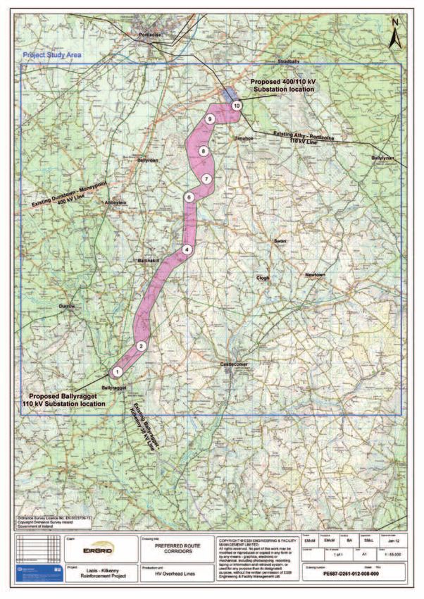
CONTENTS
1.0        INTRODUCTION                                                  1
1.1        REPORT CONTEXT                                                1
1.2        THE PURPOSE OF THIS REPORT                                    3
1.3        SUMMARY OF THE STAGE 1 PROCESS                                3

           PART A
2.0        CONSULTATION ON THE STAGE 1 REPORT                            6
2.1        STATUTORY & NON STATUTORY STAKEHOLDERS & AGENCIES             7
2.2        PUBLIC                                                        7
2.3        FEEDBACK RECEIVED                                             8
2.4        RESPONSES FROM KEY STAKEHOLDERS AND AGENCIES                  8
2.5        THE PUBLIC                                                   10

3.0        PROPOSED SUBSTATIONS                                         11
3.1        PROPOSED TECHNOLOGY                                          11
3.2        PROPOSED 400/110 KV SUBSTATION SITE                          11
3.3        PROPOSED 110 KV SUBSTATION SITE AT BALLYRAGGET               12
3.4        PROPOSED AMENDMENTS TO KILKENNY 110 KV SUBSTATION            13

4.0        MODIFICATIONS TO ROUTE CORRIDORS                             14
4.1        MODIFICATION 1                                               14
4.2        MODIFICATION 2                                               16
4.3        OTHER CONSIDERATIONS                                         16

5.0        ROUTE CORRIDOR EVALUATION                                    19
5.1        METHODOLOGY                                                  19
5.2        ROUTE CORRIDOR CLASSIFICATION                                20
5.3        COMPARATIVE EVALUATION CRITERIA                              22

6.0        LEAD CONSULTANT’S CONCLUSION (PART A)                        25

           PART B
7.0        CONSULTATION AND LANDOWNER ENGAGEMENT                        27
7.1        SELECTION OF AN INDICATIVE LINE ROUTE                        27
7.2        PUBLIC CONSULTATION AND LANDOWNER ENGAGEMENT                 27
7.3        MODIFICATIONS MADE TO THE PRELIMINARY INDICATIVE LINE        28

8.0        400 AND 110 KV CONNECTIONS TO COOLNABACKY SUBSTATION         30
8.1        400 KV CIRCUITS INTO THE PROPOSED COOLNABACKY SUBSTATION     30
8.2        110 KV CIRCUITS INTO THE PROPOSED COOLNABACKY SUBSTATION     33

9.0        LEAD CONSULTANT’S CONCLUSIONS (PART B)                       35

10.0       ENVIRONMENTAL IMPACT ASSESSMENT AND APPROPRIATE              36
           ASSESSMENT SCREENING REPORTS
10.1       SCREENING REPORT FOR ENVIRONMENTAL IMPACT ASSESSMENT (EIA)   36
10.2       SCREENING REPORT FOR APPROPRIATE ASSESSMENT (AA)             36

11.0       NEXT STEPS                                                   37

                                          II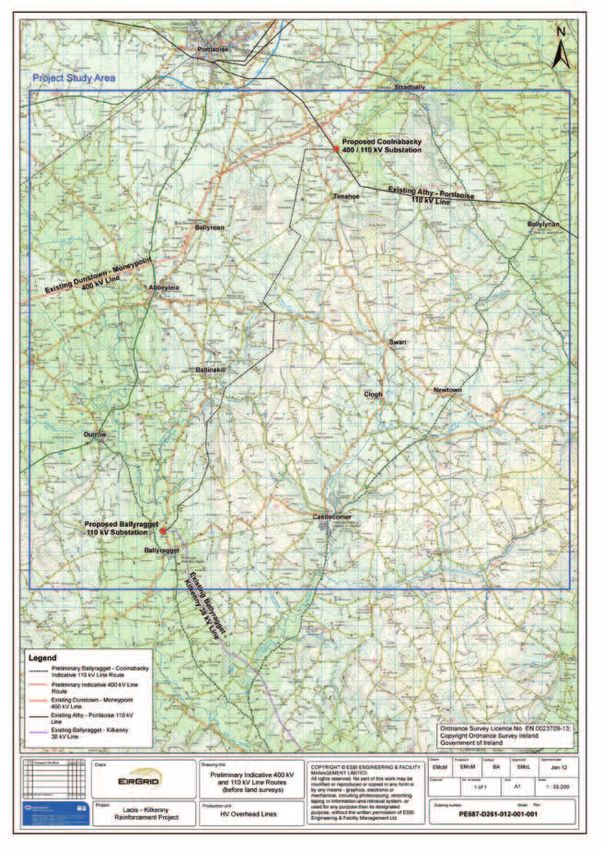
Figures
Figure 1.1    Laois-Kilkenny Reinforcement Project Planning Application - Project Roadmap
Figure 1.2    Coolnabacky 400/110 kV Substation Site
Figure 1.3    Single Circuit 110 kV Overhead Line Design
Figure 1.4    Emerging preferred 110 kV Line Route Corridor
Figure 3.1    Illustration of a 400/110 kV GIS substation
Figure 3.2    Proposed 400/110 kV substation site
Figure 3.3    Ballyragget 110 kV proposed substation site
Figure 3.4    Kilkenny 110 kV substation site
Figure 4.1    Line route corridor before and after modification
Figure 4.2    Map issued by the GSI showing the extent of Timahoe Esker
Figure 4.3    Line route corridor before and after modification
Figure 4.4    Proposed 400 and 110 kV route corridors before modifications
              (Emerging Preferred Corridors)
Figure 4.5    Proposed 400 and 110 kV line route corridors (Preferred Route Corridors)
Figure 5.1    Route Corridor Alternatives identified in the Stage 1 Report
Figure 6.1    Preferred Route 400 and 110 kV Route Corridors
Figure 7.1    Preliminary Indicative Overhead line route
Figure 8.1    Typical Line/Cable Interface Compound
Figure 8.2    An existing 400 kV double circuit line close to Moneypoint generating station in
              County Clare
Figure 8.3    An existing 110 kV single circuit line
Figure 8.4    110 kV line lattice steel angle tower
Figure 11.1   The indicative 400 and 110 kV line routes to progress to Stage 3

Tables
Table 2.1     Stage 1 Consultation Milestones
Table 2.2     Breakdown of the feedback received from the general public since the launch of the Stage
              1 Report up to December 2011
Table 5.1     Route Corridor Appraisal Ratings
Table 5.2     Primary Appraisal for all Route Corridors and Sub-Route Corridors
Table 8.1     Overall comparison of all four methods reviewed for the connecting the Dunstown
              – Moneypoint 400 kV line

Appendices
Appendix A    List of Key Stakeholders issued with Consultation Pack
Appendix B    Newspaper Notice
Appendix C    Project Stage 1 Briefing Document
Appendix D    Final winter bird survey
Appendix E    Preliminary Indicative Overhead line route as issued to landowners on August 8th, 2011
Appendix F    Sample of documentation issued to landowners on August 8th, 2011
Appendix G    Pre-Survey Interview Form
Appendix H    Sample of letter issued to landowners who refused access for walkover surveys on initial
              pre-survey interview
Appendix J    400 kV Overhead Line v Underground Cable Feasibility Study
Appendix K    Line Route to Progress to Stage 3 (Design Stage) without Constraints
Appendix L    Line Route to Progress to Stage 3 (Design Stage) with Constraints
Appendix M    Stage 1 Screening Natura Impact Statement Report

                                                   III
1.0          Introduction
1.1          Report Context
EirGrid, the statutory Transmission System Operator, require the Laois - Kilkenny Reinforcement Project in order
to reinforce the transmission network in the South East and Midlands regions.
The Transmission System or National Grid is the high voltage electricity system and is made up of a network of
lines, cables and substations operating at voltages of 110 kV, 220 kV and 400 kV.
The project is required in order to improve the quality and security of the electricity supply to the region thereby
ensuring continued compliance with the Transmission Planning Criteria (the technical standards to which the
grid must comply).
The project consists of the following components:
   • A new 400/110 kV substation near Portlaoise, County Laois. The existing Athy-Portlaoise 110 kV and
   	Dunstown-Moneypoint 400 kV overhead lines will connect to this new substation.
   • A new 110 kV extension to the existing 38 kV substation in Ballyragget, County Kilkenny.
   • A new 110 kV circuit between the new 400/110 kV substation near Portlaoise and the new 110 kV
     substation extension in Ballyragget, Co. Kilkenny.
   • Change in operational voltage of the existing Ballyragget-Kilkenny overhead line from 38 kV to 110 kV
     including necessary works at Kilkenny 110 kV substation.
The process from project initiation through to lodgement of a planning application has been broken into 4 distinct
stages, as per the project roadmap shown in Figure 1.1, with each stage having its own principal objective.
It is not intended to rewrite the contents of the Stage1 Report1 in this Stage 2 Report, other than to present
its key findings. As such, for a complete and thorough understanding, this Stage 2 Lead Consultant’s Report,
prepared by ESB International, should be read in conjunction with the Stage 1 Report available on EirGrid’s
project webpage:
www.eirgridprojects.com/projects/laoiskilkenny
Hard copies are also available on request.
This report outlines the key findings since the publication of the Stage 1 Report.

1 When referring to the Planning Roadmap and associated reports, the term ‘Stage’ will be used henceforth instead of ‘Phase’.

                                                                            1
Figure 1.1: Laois-Kilkenny Reinforcement Project Planning Application - Project Roadmap

                                                     2
1.2          The Purpose of this Report
As can be seen from the Project Roadmap in Figure 1.1, Stage 2 of this project is split into two distinct parts,
A & B.

1.2.1	Part A
The primary objective of Part A of this Stage 2 report is to detail the evaluation process that has been undertaken
in order to identify the preferred route corridor and the preferred substation sites for the project.
Essential to achieving this objective was the consultation process in which all interested parties (statutory, non
statutory and the general public) were given the opportunity to review and comment on the Stage 1 process,
procedures and conclusions. The Stage 1 report referred to above was published in late May 2011 and was the
primary context within which this consultation took place.
Feedback from this consultation process was reviewed and, where considered by EirGrid and the project team
to be required and justified, the route corridors and other findings previously identified in the Stage 1 report were
modified.
The output from Part A is that the emerging preferences identified in Stage 1 become preferences.

1.2.2	Part B
The primary objective of Part B of this report is to present an indicative line route within the preferred corridor and
to outline the procedure by which subsequent landowner identification and engagement occurred in respect of
confirming the indicative line route. Further consultation with the wider community also took place. All feedback
from this stage of the process was again reviewed by the project team and modifications, where considered
appropriate, were made to the indicative line route. The indicative line route identified in Section 9 of this Stage
2 Report represents what the project team consider to be the most appropriate option, having regard to all
technical, environmental and community criteria and to public and landowner consultation and engagement.

1.3          Summary of the Stage 1 Process
The Stage 1 process of information gathering consisted of the following steps:
   • Presented the need for the project;
   • Established a study area for the project;
   • Identified environmental and other constraints within the defined study area;
   • Identified the preferred substation technology for the 400/110 kV substation;
   • Identified an emerging preferred 400/110 kV substation site;
   • Identified potential route corridor options for the project within the defined study area;
   • Evaluated the various corridor options, having regard to environmental and engineering constraints;
   • Identified an emerging preferred corridor for the project within which to route the proposed 110 and 400
     kV circuits; and
   • Provided the opportunity for public and stakeholder consultation throughout this stage.
The conclusion of the Stage 1 Lead Consultant’s Report identified the Lead Consultant’s emerging preferred
substation site for the 400/110 kV substation and also identified the emerging preferred route corridor for the
110 kV circuit between Laois and Ballyragget.
In summary, the key findings of the Stage 1 report are as follows:
   • The emerging preferred substation technology for the 400/110 kV substation is GIS (Gas Insulated
     Switchgear) – built primarily indoors, this is the smallest and most compact substation type. The station
     compound would be of the order of 3 acres in overall size2 - see Chapter 3 for further details.
   • The emerging preferred location for the 400/110 kV site is in the townland of Coolnabacky on the southern
     boundary of the substation study area. It is adjacent to the existing 110 kV overhead line and approximately
     1.4 km from the existing 400 kV overhead line (see Figure 1.2).

2 The size of the compound has been determined following consultations with the GIS equipment manufacturers on the size of the buildings required.

                                                                           3
Figure 1.2: Coolnabacky 400/110 kV Substation Site (see red marker on map)
  • The emerging preferred connection methodology for the 110 kV circuit from Coolnabacky to Ballyragget is
    single circuit overhead line design (see Figure 1.3).

Figure 1.3: Single Circuit 110 kV Overhead Line Design

                                                    4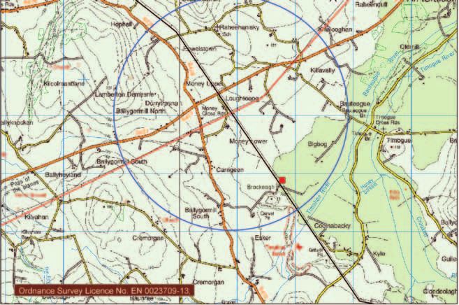
The emerging preferred route corridor for the 110 kV overhead line between Coolnabacky and Ballyragget
stations is identified in Figure 1.4.

Figure 1.4: Emerging preferred 110 kV Line Route Corridor

                                                    5
Part A
2.0 Consultation on the Stage 1 Report
The consultation based on the Stage 1 report is a key element of the project, as it is vital to get as much feedback
from all concerned parties in order to provide as much information as possible, so as to inform subsequent
decisions regarding route and site identification and confirmation.
The output of these consultations was that the project team were fully informed of key issues and constraints in
respect of the emerging preferences identified in Stage 1.
The consultation can be broadly categorised as statutory and non statutory stakeholder agencies/bodies and
the general public. The principles behind the consultation remain the same for all groups, i.e. to engage in
open, honest and meaningful discussion and evaluating and incorporating where possible or appropriate, all
suggestions and modifications brought to the attention of or indeed identified by the project team.
Table 2.1 summarises the primary milestones of consultations to date.
Milestone Date Purpose Venue / Newspaper
Newspaper Notice No. 1 26th Oct 2009 Description of Proposed Kilkenny People,
Project & Definition of Leinster Express,
Study Area Laois Nationalist,
Carlow Nationalist,
Kildare Nationalist,
Leinster Leader
Newspaper Notice No. 2 14th June 2010 Description of Proposed Project Kilkenny People,
Presentation of Constraints Leinster Express,
Recorded in Project Study Area Laois Nationalist,
Advertise Open Days Carlow Nationalist
Open Days 1 June 17th & 18th 2010 Provide information to Heritage Hotel Portlaoise
the general public, their & The River Court Hotel
public representatives Kilkenny
and the media on the
proposed project
Answer any questions
from the public
Information gathering
Stage 1 Report Published (May 20th, 2011)
Newspaper Notice No. 3 May 31st to June 6th Description of Proposed The Kilkenny People, The
2011 Project. Leinster Express, The
Advertising Stage 1 Offaly Express and The
Report Laois Nationalist.
Advertising Open Days
Open Days 2 June 9th, 10th, 24th & Provide information to Heritage Hotel Portlaoise,
30th 2011 the general public, their The River Court Hotel
public representatives Kilkenny & Canon Malone
and the media on the Hall, Ballyragget
proposed project
Answer any questions
from the public
Information gathering
Newspaper Notice No. 4 June 22nd to 24th 2011 To promote awareness of The Kilkenny People, The
project Leinster Express The
To thank people for inputs Offaly Express and The
received during the consultation Laois Nationalist
on the Stage 1 Report
Table 2.1: Stage 1 Consultation Milestones3
3 This summary does not list any meetings with individuals, local stakeholder groups, or statutory stakeholders that took place. EirGrid were also present at
local events such as the National Ploughing Championships in Athy in 2010 and 2011
62.1 Statutory & Non Statutory Stakeholders & Agencies
The project team endeavoured to work with key stakeholders and agencies with a view to ensuring that the process of
identifying the preferred route corridor and site took into account their particular area of expertise and responsibility.
A consultation pack including cover letters, a project briefing document and a copy of the Stage 1 Lead
Consultants report (with associated maps) was issued on May 20th 2011. These letters were followed up with
phone calls, e-mails and meetings where appropriate.
A list of all those who were issued this documentation is available in Appendix A.
The feedback received is outlined in sections 2.4 and 2.5.
2.2 Public
The local knowledge of landowners and local communities is invaluable to the project team, and therefore their
input is vital. The project team must merge this local knowledge with technological and environmental survey and
assessment, experience and expertise in line routing, to come up with an optimum solution.
The Stage 2 public consultation process for this project took the form of:
Newspaper Notices
Upon completion of the Stage 1 Report newspaper notices were taken out in The Kilkenny People, The Leinster
Express, The Offaly Express and The Laois Nationalist newspapers. The purpose of these newspaper notices
was to announce the availability of the report and its key messages, to provide contact details for the project
team and also to announce forthcoming Open Days (see Appendix B).
Briefing Document
A project specific briefing document (May 2011) (see Appendix C) which provided key findings of the Stage 1
report, key dates and also the contact details of the project team was produced.
The briefing document was made available online and was also posted directly to any member of the public that
left contact details with EirGrid or any of the project team during the Stage 1 consultations.
Information brochures were also dropped to local shops, credit unions, libraries and County Council offices in
Kilkenny, Ballyragget, Ballinakill, Timahoe, Stradbally and Portlaoise ahead of the open days.
Telephone, Email, Website and Postal
A project specific website www.eirgridprojects.com/projects/laoiskilkenny is maintained which facilitated
access to project data as well as providing updates as and when they occurred. A dedicated email address was
established for the project and a telephone number and postal address was provided for people to contact the
project team directly.
Public Information Days
Public information days were held in the River Court Hotel in Kilkenny City on 9th June 2011, the Heritage Hotel
in Portlaoise on 10th June 2011, and in Canon Malone Hall in Ballyragget on the 24th and 30th of June 2011.
The public information days were advertised in The Kilkenny People, The Leinster Express The Offaly Express
and The Laois Nationalist newspapers published between 31st May and 6th June 2011. A copy of the newspaper
notice is contained in Appendix B. Hard copies of project reports and maps were available at this open day, and
remain available on request.
Members of the project team were available at the Open Days to discuss any aspect of the project including
such issues as justification, route selection, environmental, health and EMF.
To co-ordinate interaction with the general public throughout the project, the project team implemented a
process ensuring that general and individual concerns were directly addressed by the project team. This primarily
occurred through:
• Contact made through e-mail, by letter or telephone.
• All information received made available to all members of the project team for review.
• The Lead consultant liaised with the EirGrid Project Manager to decide on the appropriate course of action.
• A member of the project team contacted the individual concerned and is their personal point of contact for
the duration of the project.
• The project team were (and continue to remain) available to meet on request.
72.3 Feedback Received
Following the publication of the Stage 1 Report in late May a period of approximately 5 weeks (up to the 24th
June 2011) was allocated for all stakeholders to make submissions to the project team. Meetings were also held
with various statutory and non statutory stakeholders during this time.
The review and analysis of all feedback received throughout the consultation period is important for the project
team.
The project team must assess if any of the feedback causes:
Need for alternatives to, or modification of the project; or
Evaluation of proposed network i.e. minor deviations or the use of alternative routes submitted.
Table 2.2 is a breakdown of the feedback received from the general public since the launch of the Stage 1 Report
up to December 2011.
Open Day Open Day Open Days E-mails Letters Phone Calls
Kilkenny Portlaoise Ballyragget
8 Visitors 24 Visitors 8 Visitors 28 2 4
Table 2.2: Breakdown of the feedback received from the general public since the launch of the Stage 1 Report
up to December 2011
Section 2.5 describes a more detailed descripition of the response from the general public.
2.4 Responses from Key Stakeholders and Agencies
Fifty stakeholder agencies were issued copies of the consultation pack on May 20th, 2011. EirGrid and ESBI
received replies from 10 of these agencies. The following is a brief description of their replies.
2.4.1 An Bord Pleanála
An Bord Pleanála acknowledged receipt of the Stage 1 Report (by letter dated 30th May 2011) and advised
that it was their opinion that “the next pre-application consultation meeting should take when a preferred route
option has been identified”.
2.4.2 Kilkenny County Council
A meeting was held with Kilkenny County Council planners in the County Council offices on June 28th 2011.
EirGrid and ESBI gave the Kilkenny County Council planners an overview of the project. Kilkenny County Council
requested that they are to be kept informed of the proposed development.
2.4.3 Kildare County Council
Kildare County Council issued a letter (dated 2nd June 2011) stating Kildare County Council “does not wish to
make any comment on the project at this stage but would appreciate update on the later stages of the project”.
2.4.4 National Parks and Wildlife Service (NPWS)
The NPWS were contacted by the project ecologist. From this correspondence the project team were made
aware that the River Nore was recently designated as a Special Protection Area (SPA) under the EU Birds
Directive (2009/147/EC), Site Code 004233, this is within the study area. Further information on this can be
seen in section 4.3.2.
82.4.5 National Roads Authority (NRA)
A letter was received from the National Roads Authority (dated 29th June 2011) referring the project team to
several policy documents including:
• The Authority’s Policy Statement on Development Management and Access to National Roads;
• DoEHLG Spatial Planning & National Roads (Draft) Guidelines for Planning Authorities, June 2010;
• Environmental Impact Assessment of National Road Schemes – A Practical Guide;
• Guidelines for the Treatment of Noise and Vibration in National Road Schemes;
• Guidelines for the treatment of Air Quality During the Planning and Construction of National Road Schemes;
• Road Safety Audit (NRA HD 19/09); and
• Traffic and Transport Assessment Guidelines (TTA).
The letter also advised that a full and comprehensive traffic assessment should be carried out.
2.4.6 Inland Fisheries Ireland
A letter from Inland Fisheries Ireland (formally Central Fisheries Ireland) referred to a previous correspondence in
which several issues were highlighted. The following is a summary of these issues:
• Consideration should be given to all river tributaries irrespective of size;
• Care on the placement of line supporting structures relating to silt and erosion;
• Care in relation to the use of concrete relating to pH values;
• Care in relation to earth movement and the production of silt;
• Care in relation to the use of oils and fuels;
• From a visual perspective Inland Fisheries Ireland would prefer if the circuit is undergrounded,
however it also acknowledged that this method has the potential to generate negative impact on the water
habitats and state that if this method is to be used that an under bore is used for river crossings; and
• The line sag over waters should not be a safety concern for anglers.
2.4.7 Fáilte Ireland
A meeting was held with Fáilte Ireland on June 16th 2011 at which EirGrid and ESBI gave an overview of the
project. Subsequent to that meeting Fáilte Ireland made a submission (by email dated 24th June 2011) to the
project team. The submission highlighted that there are a number of important tourist assets in the vicinity of the
study area including Abbeyleix Heritage Town, the Rock of Dunamase, Castlecomer Discovery Park, as well as
the uplands that lie between the N8 and the N78.
Fáilte Ireland holds the view that the emerging preferred corridor as highlighted in the Stage 1 report “is the one
to have the least effect on the tourism amenity value of the area”.
Fáilte Ireland also stated that they are not aware of any negative impacts on the tourism amenity value of the area
that are likely to arise from the proposed 400/110 kV substation.
2.4.8 An Taisce
An Taisce replied (by email dated 25th May 2011) stating at this stage “there are no major elements that would
be problematic from our point of view.”
2.4.9 Kilkenny Strategic Policy Committee
Kilkenny Strategic Policy Committee wrote to ESB International on 25th August 2011 requesting an open day
in Ballyragget. Kilkenny Strategic Policy Committee were made aware that open days were previously held in
Ballyragget on the 24th and 30th June 2011.
92.4.10 Geological Survey of Ireland (GSI)
The GSI issued a map (by email dated 8th November 2011) showing the extent of the Timahoe esker geological
heritage site recommended for CGS designation under the IGH 7 Quaternary Theme (see Figure 4.2).
2.4.11 Office of the Minister for Agriculture, Fisheries and
Food
A letter (dated 27th May 2011) was received from the Office of the Minister for Agriculture, Fisheries and Food
stating that the project will be brought to the attention of the Minister.
2.5 The Public
There has been a steady response from the general public which has continued past the official consultation
period end date of the 30th June 2011. In addition to general queries, expressions of objection were received.
Table 2.2 lists the correspondence received to date. The majority of people responding are living along or in close
proximity to the emerging preferred route and/or the 400/110 kV substation site. There also has been ongoing
correspondence with a local opposition group located close to the 400/110 kV substation area.
Contact with the project team was in most cases initially made through the project e-mail, details of which where
publicised on the project briefing document. Phone calls were the next preferred method of communication. Post
was the least used method.
The main submission themes from the public were:
• Health and Safety issues, including electromagnetic fields (EMF);
• Landscape and visual impact;
• Need for the project; and
• Undergrounding the 400 and 110 kV connections.
103.0 Proposed Substations
3.1 Proposed Technology
The Stage 1 report identified Gas Insulated Switchgear technology (GIS) as the emerging preferred technology
for the 400/110 kV substation. This technology allows for a smaller compound which generally has less visual
impact in its setting. The substation compound will be approximately 3 acres in overall area with the 400 kV and
110 kV switchgear being housed in moderately sized buildings as can be seen in Figure 3.1.
It is planned to use Mixed Technology Switchgear (MTS) as the preferred technology for the Ballyragget 110
kV substation. This technology is a form of outdoor GIS technology and takes up less space then the more
commonly used Air Insulated Switchgear technology (AIS). Kilkenny is an AIS station and the bay used here will
be AIS.
No submissions were made in relation to the planned technology and currently EirGrid and ESB International are
in consultations with manufacturers in relation to finalising the layout of the planned substation.
Figure 3.1: Illustration of a 400/110 kV GIS substation
3.2 Proposed 400/110 kV Substation Site
After the iterative site selection process which is documented in the Stage 1 report, the emerging preferred
(considered the least constrained) site was established in the southern portion of the substation study area (see
Figure 3.2), in the townland of Coolnabacky. It is approximately 1.4km southeast of the existing 400 kV overhead
line and is located in an isolated area close to a disused quarry. The landholding has good topographical
enclosure and good screening vegetation. There are a low number of dwellings in the immediate vicinity and the
site is accessed from an existing quarry road, with good screening from the R426 and R427 roads.
11Figure 3.2: Proposed 400/110 kV substation site (see red marker on map)
The site is the starting point for the line route corridors to Ballyragget (for the 110 kV route corridors) and to the
existing Dunstown – Moneypoint 400 kV line (for the 400 kV route corridor).
3.2.1 Proposed 400/110 kV Substation Name
All substations around Ireland are given a name. Generally a name is chosen based on the substation location.
In this case the proposed 400/110 kV substation is in the townland of Coolnabacky. This name has been
chosen as the name for the substation and will be referred to as such henceforth.
3.3 Proposed 110 kV Substation Site at Ballyragget
It is proposed to construct a 110 kV substation behind the existing 38 kV substation in Ballyragget. The land
behind the existing 38 kV station is ESB owned and is of sufficient size to accommodate the proposed 110 kV
MTS substation (see Figure 3.3).
Two 110 kV lines will connect to the substation extension, one proposed new line (from Coolnabacky 400/110
kV substation) and one from the existing line (the existing 38 kV line from Ballyragget to Kilkenny which is
constructed to 110 kV standards). In the case of the Ballyragget – Kilkenny line approximately 600 metres of this
line out of Ballyragget substation will need to be realigned as this section is not designed to 110 kV standards.
12Figure 3.3: Ballyragget 110 kV proposed substation site
3.4 Proposed Amendments to Kilkenny 110 kV substation
A new 110 kV bay and associated works to accommodate the Ballyragget connection is planned for Kilkenny
110 kV substation (see Figure 3.4). This work will primarily be carried out within the substation. This work
will include the realignment of part of the existing Ballyragget 38 kV line close to the substation and some
decommissioning work.
Figure 3.4: Kilkenny 110 kV substation site
134.0 Modifications to Route Corridors
The purpose of this section is to describe modifications made to any of the route corridors subsequent to
publication of the Stage 1 Report. Minor modifications to the route corridor at this stage of the project are normal
and typically arise as a result of a number of factors including:
1 Aerial survey and roadside review of the route corridor selected in Stage 1 of the project by the Lead
Consultant;
2 Feedback received from key stakeholders, agencies or the general public participation in the consultation
processes; and
3 Any modifications required to the emerging preferred corridor following preliminary identification of an
overhead line route.
As mentioned above, as part of the consultation process the project team were open to feedback from local
residents and landowners regarding the routing of the corridor in their locality. It was however stated clearly
in all discussions that no route corridor modification would be likely to occur if the move would have a greater
negative environmental effect, i.e. no route corridor would be modified without the modification making a neutral
or positive and beneficial contribution to the overall project.
Two modifications were made to the emerging route corridor subsequent to the publication of the Stage 1
Report.
4.1 Modification 1
Modification to the width of the emerging preferred corridor between nodes 9-10. The corridor was widened by
approximately 600 metres to accommodate a route of the 110 kV overhead line out of the 400/110 kV station
location. This line route was influenced by the extent of Timhoe Esker proposed Natural Heritage Area (pNHA),
which is also a Nature Reserve as well as the proximity of Timahoe town and the ribbon development associated
with that town. The Geological Survey of Ireland (GSI) identified the area between nodes 9 and 10 as an area
of geological significance due to the extent and presence of Timahoe Esker, see section 4.1.1. Figure 4.1
shows the line route corridor before and after the modification – the amendment arising from the modification is
illustrated in purple.
Figure 4.1: Line route corridor before and after modification
144.1.1 Route Corridor Modification due to Timahoe Esker
The Geological Survey of Ireland (GSI) submitted a map (Figure 4.2) which identified the Timahoe Esker as an
area of geological significance as part of the GSI’s Irish Geological Heritage Programme. ESBI had previously
identified the Esker, however the extent and significance of it was not fully defined. The route corridor was
reviewed and expanded to allow for the routing of a line that could avoid the Esker.
Figure 4.2: Map issued by the GSI showing the extent of Timahoe Esker
4.1.2 Environmental Consultants Review of Modification
due to Timahoe Esker
As this modification represented a change to the original emerging preferred corridor as identified in Stage 1
Report, the environmental consultants were asked to assess the modification at node 9-10.
4.1.2.1 Human Beings
The Human Beings consultants assessed the modification and concluded that the modification could have a
positive effect as the final line route has the potential to have less impact on Timahoe town and its associated
population centre and dwellings.
4.1.2.2 Cultural Heritage
The Cultural Heritage consultants assessed the modification and concluded that no changes to their submitted
reports were required, as the potential impacts have already been described.
4.1.2.3 Landscape
The Landscape consultant assessed the modification and concluded that no changes to their submitted reports
were required, as the potential impacts have already been described.
4.1.2.4 Ecology
The Ecology consultant assessed the modification to the line route corridor and concluded that from an ecological
perspective, the modification could have a positive effect as the final line route has the potential to have less
impact on Timahoe Esker part of which is a pNHA and Nature Reserve.
154.1.2.5 Soils & Geology
The Soils and Geology consultant assessed the modification to the line route corridor and concluded that from
a soils/geology perspective, the modification could have a positive effect as the final line route has the potential
to have less impact on Timahoe Esker part of which is a pNHA. This conclusion was further reinforced having
regard to the submission from the Geological Survey of Ireland.
4.1.5.6 Hydrology & Hydrogeology
The Hydrology & Hydrogeology consultant assessed the modification to the line route corridor and concluded
that from a Hydrology & Hydrogeology perspective, the modification could have a positive effect as the final line
route has the potential to have less impact on regionally important Karstified (diffuse) bedrock aquifers, sand and
gravel aquifers.
4.2 Modification 2
The western boundary of the emerging preferred corridor adjacent to Node 7 was widened by approximately 30m.
The corridor was widened at this point so as to accommodate a preliminary 110 kV line route. This modification
allows the overhead line route to continue in a straight line from Node 6 to Node 8 thereby minimising the number
of changes in direction and consequently the number of angle towers necessary. Figure 4.3 shows the line route
corridor before and after the modification. The modification is not discernible on the map due to its small area.
Figure 4.3: Line route corridor before and after modification
As the modification only widens the corridor by 30 metres at a localised point on the corridor, the modification
was deemed insignificant in environmental terms and the original environmental assessments apply.
4.3 Other Considerations
4.3.1 Midlands Heliport
During the course of consultations the presence of a heliport within the emerging preferred corridor near node
4 was brought to the attention of the project team (Midlands Heliport). Once a preliminary 110 kV overhead line
route was identified within the corridor, the impact on the operational activities of the heliport was duly assessed
and the Irish Aviation Authority (IAA) contacted and presented with the proposal and assessment. It was then
confirmed that the proposed overhead line will be below or outside any obstacle limitation requirements of the
heliport under IAA regulations.
4.3.2 Review of New Special Protection Area (SPA)
Further to the NPWS informing the project ecologist of the newly designated Nore SPA (site code 004233)
within the project study area, a review of the potential impact arising from the project on the new SPA was carried
out by the project ecologist. The review found that modification of the emerging preferred route corridor is not
necessary as a result of the newly designated SPA. This designated area overlays sections of the previously
designated River Nore and River Barrow Special Area of Conservation (SAC) (site code 2162) which was taken
into account in the original Stage 1 assessments.
On a related ecological matter, the final winter bird survey, which details the findings of a series of field surveys
carried out in the winter 2010/2011, can be seen in Appendix D, previous wintering bird surveys were provided
as part of the Stage 1 report.
164.3.3 Summary of Modifications
Figures 4.4 and Figure 4.5 show the entire proposed 110 kV route corridor before and after the modifications.
Figure 4.4: Proposed 400 and 110 kV route corridors before modifications (Emerging Preferred Corridors)
17Figure 4.5: Proposed 400 and 110 kV line route corridors (Preferred Route Corridors)
185.0 Route Corridor Evaluation
5.1 Methodology
As outlined in Chapter 4, there have been modifications to the emerging preferred corridor identified in Stage
1 Report, and it is now beneficial to re-evaluate all identified corridor options using the original evaluation
methodology.
Feedback from the consultation process (as outlined in Chapter 2 of this report) along with further investigation/
review by the Lead Consultant on the localised impact of the route corridors has been considered.
For ease of description and comparison the route corridor alternatives have been classified by node points
described in section 5.2 and illustrated in Figure 5.1 below. The following colour code is used to give a visual
representation of the Lead Consultant’s opinion on all route corridors, see Table 5.1. The results can be viewed
in tabular format in Table 5.2.
Preferred: Route Corridors in this group may have the least impact on the identified
constraints.
Less Preferred: Route Corridors in this group may have a greater impact on the identified
constraints.
Least Preferred: Route Corridors in this group may have the greatest impact on the identified
constraints.
Table 5.1: Route Corridor Appraisal Ratings
195.2 Route Corridor Classification
Figure 5.1: Route Corridor Alternatives identified in the Stage 1 Report
205.2.1 400 kV Route Corridor
The 400 kV route corridor is centred along and follows the existing Athy – Portlaoise 110 kV line from its
intersection with the Dunstown – Moneypoint 400 kV line to the proposed Coolnabacky 400/110 kV substation
site.
Approximate total length of corridor = 1.4km.
5.2.2 Western 110 kV Route Corridor
The western 110 kV route corridor exits Ballyragget substation at node 1, travels through node 5 and then on to
the proposed Coolnabacky 400/110 kV substation at node 10.
Approximate total length of corridor = 28km.
5.2.3 Central 110 kV Route Corridor
The central 110 kV route corridor exits Ballyragget substation at node 1, travels through nodes 2,3,4,6,7,8 & 9
and then on to the proposed Coolnabacky 400/110 kV substation at node 10.
Approximate total length of corridor = 26km.
5.2.4 Eastern 110 kV Route Corridor
The eastern 110 kV route corridor exits Ballyragget substation at node 1 and travels directly to the proposed
Coolnabacky 400/110 kV substation at node 10.
Approximate total length of corridor = 44km.
5.2.5 110 kV Sub-Route Corridors
5.2.5.1 Node 2 to Node 4
Approximate total length of corridor = 9km.
5.2.5.2 Node 3 to Node 7
Part of the corridor on its west side at node 7 was widened by 30m for a short distance along the corridor.
Approximate total length of corridor = 15km.
5.2.5.3 Node 5 to Node 6
Approximate total length of corridor = 5km.
5.2.5.4 Node 7 to Node 9
Approximate total length of corridor = 5.5km.
5.2.5.5 Node 9 to Node 10
Part of the corridor between these nodes was widened by approximately 0.6km as a result of feedback from the
Stage 1 process increasing from 1km to 1.6km wide.
Approximate total length of corridor = 5km.
5.2.6 Modified Emerging Preferred Corridor
Figure 4.5 shows that Modified Emerging Preferred Corridor commences at Ballyragget substation (node 1) and
is a minor variant of the Central Route Corridor passing through nodes 2,4, 6, 7, 8 and 9 then on to the proposed
Coolnabacky 400/110 kV substation at node 10.
215.3 Comparative Evaluation Criteria
All route corridors have been evaluated and compared under the following criteria having regard to feedback
received throughout the consultation process. The results of the comparative evaluation are detailed in Table 5.2.
5.3.1 Economic
5.3.1.1 Corridor Length
No new information which resulted in the alteration of the corridor lengths was identified.
5.3.2 Environment
5.3.2.1 Human Beings
Safety
This criterion of assessment will be the same for route corridors chosen. Some corridors may have more difficult
access and civil works, particularly the eastern corridor; however thorough risk assessment and implementation
of control measures established at the construction stage will make this difference negligible.
Health effects due to electric and magnetic fields
This criterion of assessment will be the same for all route corridors identified. The criteria for dealing with power
frequency EMF (electric and magnetic fields) is to refer to independent internationally recognised scientific bodies
in the area of non-ionising radiation (0-300GHz). For dealing with powerline EMF (50Hz) health concerns EirGrid
refer to the EU 1999 recommendation on limiting public exposure to EMFs. Within this recommendation the EU
use reference levels based on ICNIRP’s 1998 EMF guidelines. ICNIRP are a Non Governmental Organisation
(NGO) appointed by the WHO to deal with non-ionising EMF.
The proposed development is well within the recommended public exposure limits for all route corridors and for
the substation sites.
Localised Impact
Some sections of route corridors upon review are deemed less preferable due to greater environmental impacts.
Proximity to residential dwellings
The central corridors are less populated than the western and eastern corridors.
Noise
No differentiation between corridors for either construction or operational noise is considered necessary as the
potential impact is considered the same for all corridors.
Interference with farming practice
No differentiation between corridors is considered to occur as the potential impact is considered the same for
all corridors.
5.3.2.2 Cultural Heritage
No new information regarding cultural heritage was identified, however review by the project team reinforced the
Stage 1 conclusions.
5.3.2.3 Landscape
No new information regarding landscape was identified; however review by the project team reinforced the
Stage 1 conclusions.
5.3.2.4 Ecology
Information relating to the newly designated Nore SPA (site code 004233) has been incorporated into the route
corridor assessment. It has not resulted in changes to the Stage 1 conclusions.
225.3.2.5 Soils & Geology
The full extent of the Timahoe Esker was provided by the GSI and this has been incorporated into the route
corridor assessment. It has not resulted in changes to the Stage 1 conclusions.
5.3.2.6 Hydrology & Hydrogeology
No new information regarding Hydrology & Hydrogeology was identified; however review by the project team
reinforced the Stage 1 conclusions.
5.3.3 Existing Infrastructure
5.3.3.1 National Roads
No new information relating to National Roads was identified.
5.3.3.2 Transmission Lines
No new information relating to Transmission Lines was identified.
5.3.3.3 Bord Gais pipeline
No new information relating to Gas Pipes was identified.
Please see Table 5.2 Primary Appraisal for all Route Corridors and Sub-Route Corridors overleaf.
23Criterion Element Western Central Eastern Node 2-4 Node 3-7 Node 5-6 Node 7-9 Node 8-10 400 kV Route Modified
Corridor Corridor Corridor Corridor Emerging
Preferred Corridor
Economic Corridor Length 28km 26km 44km 9km 15km 5km 5.5km 5km 1.8km 26km
Environment Human Beings 0.5km from Crosses Special Passes close to Passes through Passes close to
Ballinakill Centre. Area of Development Ballinakill Northwest corner Ballinakill between
Includes Ballyroan. Control of Timahoe near nodes 2 and 4.
2km from Abbeyleix Timahoe Round
Centre Tower and Eskers
Cultural Highest density of High amount Clusters of Sites Clusters of Sites Clusters of Sites Passes close to Clusters of Sites
Heritage Cultural Heritage of recorded Timahoe Round between nodes 2
Sites – 56 for the monuments Tower and 4
full route corridor
1-5-10
Flora and Fauna Crosses the Crosses the River Greatest Proximity to the River Longer route, more Crosses the River Proximity to Timahoe Proximity to the River
Owenbeg River that Barrow and Nore construction Barrow and Nore construction Barrow and Nore Eskers pNHA Barrow and Nore
is part of the River cSAC & Timahoe footprint, crosses cSAC and the Nore cSAC cSAC, and the Nore
Barrow and Nore Esker pNHA cSACs several times SPA SPA
cSAC
Landscape/Visual Passes near and Traverses a High Route passes High Ground with a
24
parallel to amenities Amenity Area with through upland number of elevated
and roads and close associated scenic areas with lower ridgeline crossings
to settled areas views visual absorption,
Approximate to, and
parallel to amenities
and roads, and close
to settled areas
Soils and Geology Presence of Blanket Timahoe Esker Crosses Blanket Timahoe Esker Timahoe Esker
Table 5.2: Primary Appraisal for all Route Corridors and Sub-Route Corridors
Peat Site of Geological Peat and Kyle Spring Site of Geological Site of Geological
Significance Significance Significance
Hydrology and Regionally important Regionally Important Regionally and Regionally Important Regionally Important Regionally Important Regionally Important Regionally important Regionally important
Hydrogeology Karstified (diffuse) Karstified (diffuse) locally important Karstified (diffuse) Karstified (diffuse) Karstified (diffuse) Karstified (diffuse) Karstified (diffuse) Karstified (diffuse)
bedrock aquifer, Bedrock aquifer, Karstified bedrock Bedrock aquifer, Bedrock aquifer, Bedrock aquifer, Bedrock aquifer, bedrock aquifer, Bedrock aquifer,
sand and gravel sand and gravel aquifer, Sand and sand and gravel sand and gravel sand and gravel sand and gravel sand and gravel sand and gravel
aquifers aquifers gravel aquifers aquifers aquifers aquifers aquifers aquifers aquifers
Existing National Roads 4 3 6 0 2 3 0 1 0 3
Infrastructure
Transmission Lines 1 0 1 0 0 0 0 1 1(Connection Point) 0
Bord Gais pipeline 0 0 0 0 0 0 0 0 0 06.0 Lead Consultant’s Conclusion (Part A)
From the re-evaluation process outlined in Chapter 5, and following full consideration of feedback from the Stage
1 process, it is the recommendation of the Lead Consultant that the preferred route corridor for the 110 kV line
from Coolnabacky 400/110 kV substation to Ballyragget 110 kV substation is the emerging preferred corridor
identified in the Stage 1 Report with two minor modifications. These modifications are to the corridors’ width
at node 7 and between nodes 9 to 10. The emerging preferred route corridor for the 400 kV connection as
identified in the Stage 1 report remains the preferred 400 kV route corridor.
The Lead Consultant also recommends that the emerging preferred Coolnabacky 400/110 kV substation site as
identified in the Stage 1 report is the preferred 400/110 kV substation site for the project.
Further consultation with directly affected landowners and the wider community along with the completion of the
field walking stage of environmental assessment may result in minor changes to the preferred route corridors
to facilitate the process of identification of a feasible line route within the emerging preferred corridors. These
changes will be reviewed where necessary.
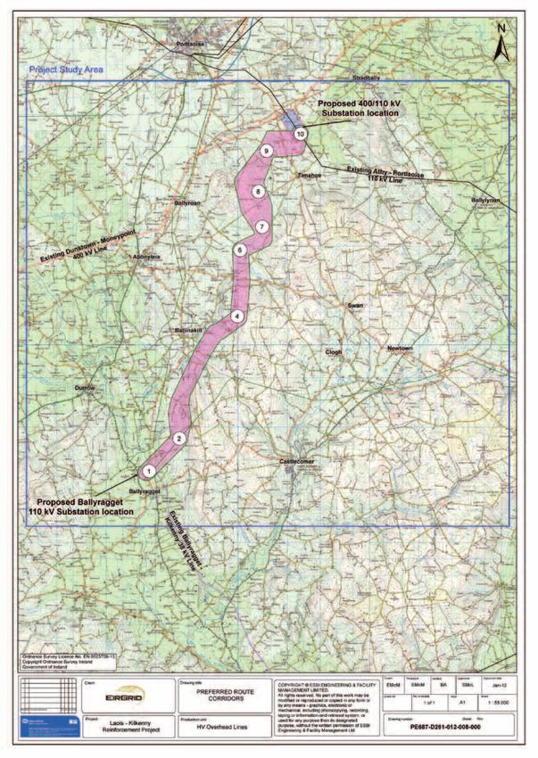
The preferred route corridor is shown in Figure 6.1 below.
25Figure 6.1: Preferred Route 400 and 110 kV Route Corridors
26Part B
7.0 Consultation and Landowner Engagement
This section provides information in relation to the identification of an indicative line route within the emerging
preferred corridor, and has particular regard to the consultation and landowner engagement stages.
7.1 Selection of an Indicative Line Route
Based on the conclusions of Part A of this report, the route corridor as shown in Figure 6.1 best avoids all
identified constraints within the study area. Selection of an overhead line route within this corridor is the next
step and this focuses on further avoidance of residential dwellings and minimisation of the potential impact of the
proposed development on land use, ecology, visual, archaeology and other localised constraints.
An initial indicative overhead line route was identified by the Lead Consultant to satisfy the criteria outlined in
Section 5 with the intention that it is used as a starting point with which to liaise with directly affected landowners.
This route was identified using the feedback from the environmental consultants together with up-to-date aerial
photography and site surveys. The preliminary indicative overhead line route identified can be seen in Appendix E
and Figure 7.1 on page 29 of this report.
7.2 Public Consultation and Landowner Engagement
It was decided for this phase of the project that public consultation on the proposed indicative line route should
be approached in three distinct phases:
• Directly affected landowners were notified of the proposal. A dedicated wayleave coordinator was appointed
to be a direct point of contact for this group.
• Landowners 50 metres either side of the proposed development were notified of the proposal. The
dedicated wayleave coordinator was appointed to be a direct point of contact for this group.
• The wider general community were kept informed of project development, with opportunities for feedback
and consultation.
7.2.1 Landowner Identification Process
Property Registration Authority (PRA) searches were conducted to identify all landowners along the indicative
line route.
Any land parcels unidentified from the above process were subsequently identified through a search of the
registry of deeds and by gathering information from other local residents and landowners.
All information gathered is confirmed with the identified landowner at the survey interview stage as outlined in
section 7.2.3 below.
7.2.2 Survey Interview Stage - Survey Interview
Documentation
A sample of the documentation issued to landowners can be seen in Appendix F. All landowners were sent the
following ‘pack’ by post.
• A Cover Letter - This letter introduces the project, invites landowners to engage in the consultation process,
makes reference to the survey letter including all attachments and introduces the lead project consultant.
Contact details for the wayleave officer appointed for the project are also included in this letter. This gives
every landowner a personal point of contact for the duration of the project.
• EirGrid Survey Letter - This letter again outlines the proposed project, the Townland, Barony and County
across which the initial indicative line route crosses and a general outline of the survey interview process.
Importantly the letter contains information regarding EirGrid’s ‘Policy Towards Landowners For Access And
Survey Of Land’.
• Landowner Survey Map - This map accompanies each survey letter and shows the initial indicative line
route (in red) as it crosses the landowner’s property. The individual property boundary of each landowner is
highlighted in blue. The structure locations have not been established at this stage therefore are not
marked on the map.
• Project Briefing Document - A further project briefing document (2nd in series – August 2011) outlining the
project need, benefits and timelines is included for information. This briefing document also includes contact
details of the project team.
27• A copy of the ESB/IFA Code of Practice for the Survey, Construction and Maintenance of Overhead
Lines.
• A Booklet was made available (on request) explaining electric and magnetic fields (EMF’s).
This pack was issued to all landowners along the indicative line route on 8th August 2011.
7.2.3 Survey Interview Stage - Survey Interview Process
Following the issue of these survey packs, landowners were called to by a member or members of an ESBI project
survey interview team working on behalf of EirGrid. The purpose of these visits was to explain the proposal to
the landowners, to seek the landowners agreement to facilitate walkover surveys by environmental consultants
and to ensure that all landowners had the opportunity to raise directly with the project team any concerns
or suggestions regarding the proposed indicative line route, and to establish a direct line of communication
between landowners and the project team.
The vast majority of landowners were contacted by an initial call to the door by a survey interview team
representative. All landowners at the time of contact were offered the opportunity to discuss the project and
complete a standard pre-survey interview form. If this time was not convenient to the landowner, a more suitable
date and time was arranged.
A pre-survey interview form was filled out with the landowner by the survey interview team representative. The
purpose of this interview is to accumulate as much information as possible regarding the landholding for the
purposes of routing and constructing the proposed overhead line. It is also an opportunity for the landowner to
express a preference for where the line structures might be sited on the landholding. Finally, it is an important
opportunity to discuss the overall project and to address any queries or concerns that might arise in respect of
the project. A copy of this interview record is left with the landowner. A copy of this form is in Appendix G.
The majority of the survey interviews were carried out between August 24th and September 23rd 2011. As of
that time most of the landowners were met however some landowners were not available or unreachable. All of
the landowners were either met directly, or if they were not directly met, contact was made through a third party
such as an agent or through a family member, where the landowner agreed to such an approach.
Whilst the majority of the landowners have facilitated the walkover surveys by the environmental consultants,
some refused access and were subsequently sent a second letter on 9th January 2012 requesting permission
for access to carryout surveys and discuss how impacts on farming activities could be minimised. The letter
also states that the line will be designed with the information available in the event that the landowner is still not
willing to facilitate the walkover surveys; a copy of this letter is in Appendix H. By the end of November 2011
the environmental consultants had gained access to approximately 72% of those landowners interviewed along
the indicative line route.
7.2.4 Consultation with the Wider Community
Consultation with the wider community has continued during the project through project updates published on
the project website. The project team have replied to several letters, emails and telephone calls. The project
team also have provided information to local media.
In September 2011 EirGrid had a stand at the National Ploughing Championships in nearby Athy, where members
of the project team were on hand to deal with any queries on the project from the general public.
7.3 Modifications made to the Preliminary Indicative Line
Route
Following feedback from landowners and from the environmental consultants as a result of walkover and desktop
studies a number of modifications were made to the initial indicative 110 kV line route issued to the landowners.
The majority of the modifications are only moves of a few metres and were requested by either the environmental
specialists or the line route designer to improve upon the original indicative line route. Other modifications were
requested by the landowners, some of which are significant and the environmental consultants were requested
to review these further.
At this stage, intermediate poleset locations are not decided. Angle tower locations are identified and required at
changes in direction. Refusal to permit the environmental consultants on to lands to do walkover surveys resulted
in placing some angle masts on improved grasslands with less ecological value than hedges for example.
The modified indicitave alignment is shown in Appendix K and Figure 11.1 on page 38 of this report.
28Figure 7.1: Preliminary Indicative Overhead line route
298.0 400 and 110 kV Connections to Coolnabacky
Substation
8.1 400 kV Circuits into the Proposed Coolnabacky
Substation
In order to determine the most appropriate connection method, EirGrid commissioned a feasibility study on the
connection options to the proposed Coolnabacky substation from the existing 400 kV overhead line entitled
“Assessment of 400 kV Connection Methods to Coolnabacky Substation” (see Appendix J). The proposed
substation is located approximately 1.4 km from the 400 kV line.
The Athy – Portlaoise 110 kV line is adjacent to the proposed substation; 110 kV connection options available
to the substation are by overhead line to the substation site with very short lengths of cable to the compound,
the exact arrangement of which will be determined in Stage 3.
In the feasibility study four methods of connecting the Dunstown – Moneypoint 400 kV line to the proposed
Coolnabacky 400/110 kV substation were examined:
1 Double circuit underground cable (DC UGC)
2 Single circuit underground cable(s) (SC UGC)
3 Double circuit overhead line (DC OHL)
4 Single circuit overhead line(s) (SC OHL)
In order to establish the preferred connection method ESBI produced preliminary designs for all four connection
methods, environmental assessments were then carried out by environmental consultants, and technical
suitability and costs were established for each of the methods. Using this information a preferred connection
option was recommended.
8.1.1 Environment
UGC and OHL both have an environmental impact. The impact of the OHL is predominantly visual, with a
localised impact on the ground at individual structure locations. The UGC impact on the ground is considerably
more with 1.4km of trenching required to accommodate ducting. A Line/Cable interface compound would also
be required underneath the 400 kV overhead line in order to transition the overhead line circuit to underground
cable. For a DC UGC it is estimated that this compound would be 35m x 70m in size, and would look not unlike
a small AIS substation, see Figure 8.1.
Figure 8.1 Typical Line/Cable Interface Compound
30You can also read