Linkages Between Cultural Landscapes, Settlement and Ethnicity In Rural Areas: Example Of DüzceUğursuyuand Aksu Watersheds - Diamond Scientific ...
←
→
Page content transcription
If your browser does not render page correctly, please read the page content below
5th International Conference on Civil Engineering,Architecture and Urban Planning Elites
               Paris, France                                                       November 2-4, 2018

Linkages Between Cultural Landscapes, Settlement
         and Ethnicity In Rural Areas: Example Of
            DüzceUğursuyuand Aksu Watersheds

 Pınar GÜLTEKİN-Osman UZUN-Yaşar Selman GÜLTEKİN-Sinem ÖZDEDE-Sertaç KAYA
     Duzce University Faculty of Forestry 81620 Konuralp Campus Duzce/TURKEY
                    E-mail address: pinargultekin@duzce.edu.tr,
osmanuzun@duzce.edu.tr,selmangultekin@duzce.edu.tr, sinemozdede@duzce.edu.tr,
                              sertackaya@duzce.edu.tr

                                         Abstract
Rural settlements are environments where local architectural examples are
widespread, and reflect the geographical conditions, cultural structure, and lifestyle of
societies to spaces. Unlike cities that are increasingly similar to each other under the
influence of globalization, rural areas are still peculiarly shaped by their geographical
location, climate, traditions, worldview, religion, social structure, production, and
consumption. However, the problem of uniformization imposed by globalization in
urban areas poses a threat to rural areas of Turkey, as well as in Europe. The European
Council for the Village and Small Town (ECOVAST) was founded in 1984 and its aims
are: to foster economic, social and cultural vitality and the administrative identity of
rural communities throughout Europe, and to safeguard, the sensible and imaginative
renewal of constructed and natural environments of such communities. Turkey's
National Rural Development Strategy, which has been underway since 2014 and is
scheduled to continue up to 2020, emphasizes improving the landscape in rural
settlements, increasing the quality of life in rural communities, protecting and
developing environmental and cultural values within those areas.

    Düzce and its immediate surroundings, which are located in the western region
near the Black Sea in Turkey, were determined as a study area, and have formed an
important cultural mosaic with migrations from different regions. This cultural mosaic
influenced the behavior and approaches of the first immigrant communities from their
site selection to their settlement, and to current scale of the gardens. In addition to its

                                                1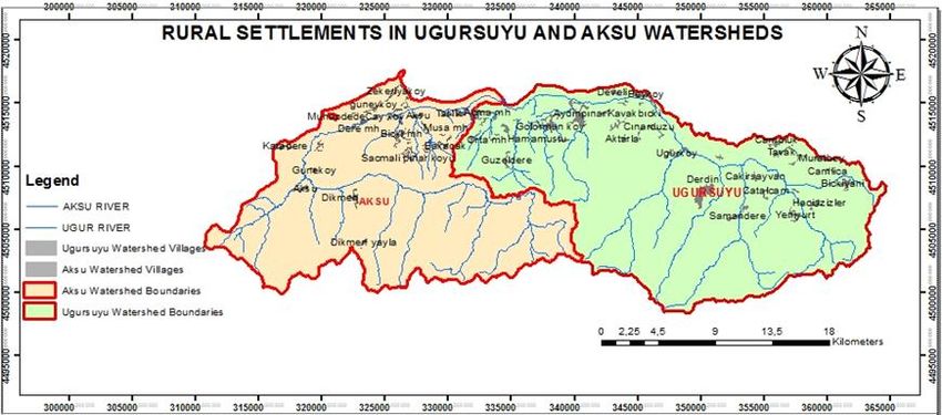
5th International Conference on Civil Engineering,Architecture and Urban Planning Elites
                Paris, France                                                       November 2-4, 2018

cultural landscape values, Düzce is a rich area with its natural landscape values and is
located in the center of two big cities, which are Ankara and Istanbul. The existing
ethnic diversity in the DüzceUğursuyu and Aksu watersheds has significant influence
on settlement types in villages, rural architecture, livelihoods, worldviews, in cultural
landscape design.

In order to evaluate the relationship between settlement forms, ethnic structures and
cultural landscapes of the villages in Düzce Uğursuyu and Aksu watersheds, 50 villages
in the area were visited and were used for cultural landscape analysis. Within the
scope of this aim, information about the importance of villages in the historical
process, the existence of historical archaeological elements, local architectural
structures, handmade crafts, religious places, festivals, ethnic structures, agricultural
production forms, highland traditions, organizational status, and monumental
preservation, have been obtained. The data obtained from 50 villages were graded on
a scale of 1 to 4, and feature tables related to villages that were created, and
correlation analysis was performed via the IBM SPSS Statistics 22 program. As a result
of the analysis, it was determined that there is a statistically significant relationship
between ethnic structure, village settlement patterns and cultural landscaping
elements. It has also been determined that the societies from the Caucaus Mountains,
and Black Sea Region reflect their cultural characteristics effectively on their
surrounding landscapes, and protect their identity to a large extent.
All the villages in the study area are grouped in regards to their characteristics and
ethnic structures, such as being of Caucasian origin, Black Sea origin, Georgian origin,
Habitan origin, Balkan origin and mixed origins. The villages, which best reflect the
cultural texture of each group were identified by a team consisting of five people.
Strategies and suggestions were developed for the protection of the rural identities,
enhancement of landscape values and the increase of prosperity levels of the
identified villages.

Keywords: Cultural Landscape, Düzce, Ethnicity, Human, Settlement, Rural Area

Introduction
    Rural settlements are areas where local architectural examples are common,
reflecting the natural and cultural structure of the region and the life style of the
period in which they belong (Eminağaoğlu and Çevik 2007). Unlike the cities that are

                                                 2
5th International Conference on Civil Engineering,Architecture and Urban Planning Elites
Paris, France November 2-4, 2018
increasingly similar to each other due to globalization, rural areas are still shaped by
their geographical location, climate, tradition, world view, privacy, religion, social
structure, production and consumption. However, uniformization problems of
globalizationimposed in cities, also pose a threat to the rural regions of Turkey as well
as in Europe (Erdem, 2012; Kiper, 2013; Muskara, 2017). Landscape changes that differ
from the traditional building face the problem of "identity loss".
Identity as specified by Ocakçı (1996); is the case of being unique that separating
any creature or object in nature from other living or objects and perceived by other
senses such as visual, auditory, etc. Being specific can be understood by the interaction
between other living or nonliving entities. Therefore, relationship is defined as the
necessary form of action in the emergence of identity (Erdem, 2012). According to
Gürsel (1993), the formation of urban or rural identity; cultural heritage or traditions,
necessities of society, geography, topography, climate and natural factors,
technological developments, ability to adapt to the changing conditions have been
associated (Erdem, 2012). It is very important to develop quick solutions about the
protected parts of cities and villages, and to increase the number of academic studies
related to rural heritage (Muşkara, 2017).
According to the Protection of the World Cultural Heritage contract
provisions(Turkey has been a side of this contract since 1983); states have committed
to the protection of cultural and natural assets within their borders.Founded in 1984
European Council For The Village and Small Town (ECOVAST)’s formal aims are: to
foster the economic, social and cultural vitality and the administrative identity of rural
communities throughout Europe; to safeguard, and to promote the sensitive and
imaginative renewal of the built and natural environments of such communities.
Turkey's National Rural Development Strategy, which has been underway since 2014
and is scheduled to continue up to 2020, emphasizes improving the landscape in rural
settlements, increasing the quality of life in rural communities, protecting and
developing environmental and cultural values within those areas.
Cultural Landscapes have been defined by the World Heritage Committee as
distinct geographical areas or properties uniquely representing the combined work of
nature and of man. According to The International Union for Conservation of
Nature (IUCN); Cultural landscape is defined as “the geographical areas associatedwith
a historical event or an activity, that encompasses both of cultural and
naturalresources as well as wildlife and domestic animals, or that exhibit various
35th International Conference on Civil Engineering,Architecture and Urban Planning Elites
Paris, France November 2-4, 2018
cultural and aesthetic values”.
In the occurrence of the concept of cultural landscape, it is emphasized that the
idea that mankind is a part of nature is effective (Çöteli, 2012). Landscapes have
different value judgments in accordance with the cultures and societies (Erdem, 2012).
Thus, the ethnic origins and traditions of the societies can be said to be influential in
the formation of the place where the first settlers of the societies they live with, and in
the formation of the cultural landscape pattern. Some of the reasons why people living
in rural areas prefer certain locations for settlement; ethnic characteristics as well as
topography can be determinant. Human communities with a specific cultural origin
form the basis of the cultural landscape by creating differences in the landscape
character type of the region in their own cultural backgrounds in different regions of a
country.
Ethnic diversity in the Düzce Uğursuyu and Aksu watersheds, which are identified
as the study area, has a direct impact on rural identity by affecting the location of
villages, rural architectural texture, local people's livelihoods and cultural landscape
patterns. The aim of the study is to group all the villages in the area according to
similar characteristics, to reveal the relationship between the ethnic structure, cultural
landscape and settlement types in a tangible way. In addition, it is aimed to develop
strategies for preserving the natural and cultural landscape values of the villages with
different rural identity characteristics and increasing the well-being of the local people.
Material
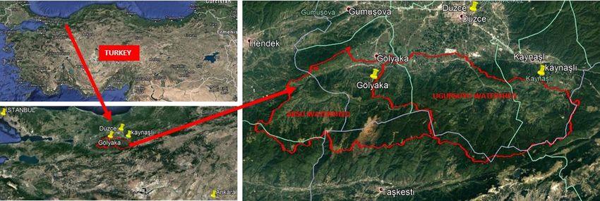
The main material of the study is the area constituted by the 339,5 km² Uğursuyu
and 280 km² Aksu watersheds (Fig. 1). Uğursuyu and Aksu watersheds are located in
the central district of Düzce, Gölyaka, Kaynaşlı and within the borders of Hendek
District of Sakarya. The study area is rich in natural and cultural landscape values. In
addition, it is a tourism center that the two big cities such as Ankara and İstanbul need
for a day trip or a weekend vacation. Uğursuyu watershed is located within the
boundaries of Düzce and Kaynaşlı districts.
45th International Conference on Civil Engineering,Architecture and Urban Planning Elites
Paris, France November 2-4, 2018
Figure 1. Study Area
Aksu watershed is located in the district of Gölyaka in Düzce province and the
district of Hendek in Sakarya province. Uğursuyu and Aksu watersheds feeding the
streams are the branches of the BüyükMelen River and are located in the western
Black Sea watershedno 13. There are a total of 50 villages in Uğursuyu and Aksu
watersheds (Fig. 2).
Figure 2. Rural Settlements in Uğursuyu and Aksu Watersheds
The data and resources of the study area are shown in Table 1.
55th International Conference on Civil Engineering,Architecture and Urban Planning Elites
Paris, France November 2-4, 2018
Table 1. The data used in the study area
Data obtained in the study Data source
Preparation of the slope, 1 / 25.000 scaled topographical maps of 1997 prepared
aspect, settlement maps and by General Command of Mapping
the altitude groups, surface
waters, transportation lines.
Land cover, stand types, 2008 forest management plan and report
closeness, proximity to forest
Population information Turkey Statistical Institute dated 2017 AddressBased
Population Registration System and Information received
from the village headman
Tourism data Nature Tourism Master Plan 2013 and information
received from Düzce Provincial Culture and Tourism
Directorate
Festivals/Carnivals Düzce Municipality, Düzce Provincial Directorate of
Culture and Tourism Data
Agriculture and animal Düzce Provincial Directorate of Food, Agriculture and
husbandry data Livestock 2016 briefing reports
General information about the Düzce Province Development Plan (2004), Scientific
study area and its studies related to the field
surroundings
Methods
The method of study consists of 3 stages as Inventory-Analysis-Synthesis.
At the 1st stage of the method, the boundaries of the study area were determined
on the watershed scale based on ecological foundations. At this stage, the literature on
the natural and cultural landscaping elements of the study area had been made.
Simultaneously, data on the method were collected and village information forms
were formed. The data obtained by the field surveys were stored in the platform of
geographical information systems, and the analyzes (slope, view, height groups) were
made to help the field studies. According to the watershed and sub-basin boundaries,
land travel plans were created, tourist attraction points were determined with natural
and cultural factors relating to villages and their surroundings.
In the 2nd phase of the method, village information forms were filled in line with
65th International Conference on Civil Engineering,Architecture and Urban Planning Elites
Paris, France November 2-4, 2018
the meetings of the headman. With village information forms; the importance of
historical archaeological elements, local architectural structures, handicrafts, religious
places, festivals and carnivals, ethnic structures, forms of agricultural production,
highland tradition, organization status, non-formal education, women's education and
monumental protection information had beenobtained, village tags of each village
were formed. The expert group consisting of 4 landscape architects and 1
forestengineers evaluated the information obtained from the village information forms
in the range of 1-4. Statistical analysis was performed in order to reveal the
relationship between ethnic structure, settlement type and cultural structure.
Correlation analysis was performed by using IBM SPSS Statistics 22 program and it was
determined that there were 3 different groups of villages. Four sample villages, which
represent the best of each group and which are in the high score range in the
evaluation of expert group, were selected in terms of natural and cultural landscape
elements varieties.
In the 3rd stage of the method, strategies were developed in line with the main
goal of ecotourism and rural development by evaluating the relationship between
ethnicity, cultural structure and settlement types. Suggestions had been made towards
sub-goals of identity, cultural structure, gastronomy, traditions, quality of life,
increasing the level of welfare and raising the awareness of the local people.
Results
Determining Settlement Properties and Statistical Analysis
The villages in Uğursuyu and Aksu watersheds had evaluated with the ECOS
method and Cultural Landscape Analysis Methods which contained in “Konya,
Bozkır-Seydişehir-Ahırlı-Yalıhüyük districts and Suğla Lake Region Landscape
Management” and “Conservation and Planning” projects by Uzun et al. (2010). The
criteria were adapted to the study area and some simplifications and additions were
made.As a result of the evaluations, the settlements were evaluated in four classes as
low (27-47 points), medium (48-68 points), high (69-89 points) and very high (90-108
points). During the evaluation, information forms filled by village headmen,
topographic maps, field observations, written sources related to the region were used.
The evaluation of the possibilities and cultural characteristics of the villages in the
Uğursuyu and Aksu watersheds are given in Table 1 and Table 2.
75th International Conference on Civil Engineering,Architecture and Urban Planning Elites
Paris, France November 2-4, 2018
Table 1. The possibilities and cultural characteristics of the villages in the UğursuyuWatershed
Settlements
Çakırhacı İbrahim
Aydınpınar
Gölormanı
Kavakbıçkı
Çınardüzü
Settlement Criteria
Bıçkıyanı
Duraklar
Kaledibi
Konaklı
Aktarla
Beyköy
Derdin
Develi
Topographic Structure Diversity 4 3 3 2 4 3 3 4 2 4 4 2 2
Forest Existence 4 3 3 1 4 3 3 4 1 4 4 1 1
Proximity to Efteni Lake 3 3 4 3 1 3 3 1 1 4 3 4 4
Young Population Existence 3 2 4 2 1 1 2 3 3 3 2 2 1
Education Status 2 2 2 3 4 3 3 4 3 3 2 3 3
Tourism Awareness Level 2 3 3 2 3 2 2 4 4 4 2 4 3
Facilities of Accommodation for
1 1 2 1 3 1 1 2 3 4 1 3 1
tourists
Transportation Infrastructure Quality 3 3 4 4 2 3 3 3 4 4 2 4 4
Distance to center district 3 2 2 2 4 3 3 3 3 3 3 4 4
Health Institution 3 1 3 1 1 1 1 2 4 4 1 2 2
Infrastructure service (waste water,
2 2 2 2 4 2 2 2 4 4 2 4 2
electricity, water, communication etc.)
Food & beverage locations (trout
2 2 3 1 3 1 1 3 4 4 1 4 3
facilities etc.)
Current recreational activities 2 2 3 2 3 2 2 4 4 4 2 4 3
Plant Production 4 4 4 4 4 4 4 4 4 4 4 4 3
Animal production 3 3 3 3 4 3 3 3 3 3 3 3 3
The importance in historical process 2 2 2 2 2 2 2 2 1 3 2 2 2
Historical archaeological features
1 1 1 1 2 1 1 1 1 2 1 1 1
and areas
Local architectural structures 2 2 2 2 3 2 2 2 2 4 1 2 2
Handicrafts 2 2 2 1 2 1 1 2 1 4 1 1 1
Religious places 1 1 1 1 2 1 1 1 1 1 1 1 1
Festivals and carnivals 1 1 1 2 2 1 1 2 3 3 1 4 2
85th International Conference on Civil Engineering,Architecture and Urban Planning Elites
Paris, France November 2-4, 2018
Agricultural industry 1 1 2 2 1 1 1 2 2 3 1 2 2
Highland tradition 2 2 1 1 3 3 2 1 2 4 2 1 1
Associations and Cooperatives 2 1 2 2 2 3 1 3 2 3 2 2 2
Facilities of Non-formal training 2 2 2 1 1 2 1 2 3 4 1 2 2
Women's training 2 1 2 1 2 1 1 2 2 4 1 2 2
Object that necessity to protect 1 1 2 1 2 1 1 1 1 4 1 1 1
Total Points 60 53 64 50 69 54 51 67 68 94 51 69 58
Table 2. Possibilities and cultural characteristics of the villages in Aksu Watershed
Settlements
Bekiroğlu-Güneyk
Hacısüleymanbey
Saçmalıpınar
Yunusefendi
Muhabdede
Hamamüstü
Settlement Criteria
Hacıyakup
Kadifekale
Taşlıkköy
Çamlıbel
Zekeriya
Sarıdere
Bakacak
Dikmen
Çayköy
Aksu
öy
Topographic Structure
4 3 3 3 3 3 3 2 3 3 4 3 3 4 3 2
Diversity
Forest Existence 3 4 4 4 3 4 4 3 4 3 4 3 4 4 3 2
Proximity to Efteni Lake 3 3 4 3 4 4 4 4 4 4 3 3 2 2 2 2
Young Population
3 3 2 2 2 2 3 3 2 2 2 2 2 3 2 2
Existence
Education Status 3 2 2 2 2 2 4 4 2 2 2 2 2 3 2 2
Tourism Awareness Level 4 2 2 2 2 2 4 2 2 2 2 2 2 4 2 2
Facilities of
Accommoda-tion for 3 1 1 1 1 1 3 1 1 1 1 1 1 2 1 1
tourists
Transportation
3 2 2 2 2 2 2 4 2 2 2 2 2 2 2 3
Infrastructure Quality
Distance to center district 3 3 3 3 3 3 3 3 3 2 3 2 3 3 3 3
Health Institution 1 2 1 1 1 1 1 3 1 1 1 1 1 3 1 1
Infrastructure service
(waste water, electricity, 3 2 2 2 2 2 2 2 2 2 2 2 2 3 2 2
water, communication etc.)
Food & beverage locations 3 3 2 2 2 3 3 3 2 3 2 2 2 3 2 2
95th International Conference on Civil Engineering,Architecture and Urban Planning Elites
Paris, France November 2-4, 2018
(trout facilities etc.)
Current recreational
4 2 2 2 2 3 3 2 3 2 2 2 2 3 2 2
activities
Plant Production 4 3 3 3 3 3 3 4 3 3 3 3 3 3 3 3
Animal production 3 3 3 3 3 3 4 3 3 3 3 3 3 3 2 2
The importance in
2 2 2 2 2 2 2 3 2 2 2 2 2 2 2 2
historical process
Historicalarchaeological
1 1 1 1 1 1 1 1 1 1 1 1 1 1 1 1
features and areas
Local architectural
2 2 2 2 2 1 2 2 2 2 2 2 2 2 2 2
structures
Handicrafts 2 2 2 2 1 2 2 3 1 2 2 2 1 2 1 1
Religious places 1 1 2 1 1 1 1 1 1 1 1 2 1 1 1
Festivals and carnivals 2 1 2 2 1 1 2 3 1 2 2 2 2 2 2 1
Agricultural industry 2 1 1 1 2 1 1 1 1 2 1 1 1 1 1 1
Highland tradition 2 2 2 2 1 2 2 2 2 2 2 1 2 2 2 1
Associations and
2 2 1 2 1 1 2 3 1 2 2 1 1 2 2 2
Cooperatives
Facilities of Non-formal
2 2 2 2 1 2 2 2 1 2 2 2 2 2 1 2
training
Women's training 2 2 2 2 1 2 2 2 1 2 2 2 2 2 1 2
Object that necessity to
1 1 1 1 1 1 1 3 1 1 1 1 1 1 1 1
protect
Total Points 68 57 56 54 50 55 66 69 52 56 56 51 53 65 49 48
When examining the Table 1 and Table 2; It has seen that Aydınpınar village has
been determined as very high in terms of its cultural texture and facilities. The villages
of Konaklı, Derdin and Güzeldere have been seen that have high opportunities and
cultural texture. In terms of ethnic background; The Güzeldere village represents the
settlers of Karadeniz, Konaklı and Derdin villages represent the Caucasian origin
settlers, and Hacıyakup village represents Georgian origin settlers.Aydınpınar is a
settlement with mixed ethnic origin settlers in the area. Each settlement reflects a
distinct diversity of ethnic diversity and cultural landscape textures.
105th International Conference on Civil Engineering,Architecture and Urban Planning Elites
Paris, France November 2-4, 2018
Correlation analysis has performed by using IBM SPSS Statistics 22 program in
order to explain the relationship between settlement characteristics, cultural texture
and ethnicity. There is a statistically significant relationship between topographic
structure, presence of local architectural texture and ethnicity (Table 3).
Table 3. Topographical structure, Local Architecture Texture and Ethnicity Correlation Analysis
Topographic
Architectural Structure Ethnicity
Pearson Correlation 1 ,040 -,184
Architectural
Sig. (2-tailed) ,784 ,201
Sum of Squares and Cross-products 10,880 ,440 -6,160
Covariance ,222 ,009 -,126
N 50 50 50
Pearson Correlation ,040 1 -,708**
Topographic
Sig. (2-tailed) ,784 ,000
Structure
Sum of Squares and Cross-products ,440 11,220 -24,080
Covariance ,009 ,229 -,491
N 50 50 50
Pearson Correlation -,184 -,708** 1
Sig. (2-tailed) ,201 ,000
Ethnicity
Sum of Squares and Cross-products -6,160 -24,080 103,120
Covariance -,126 -,491 2,104
N 50 50 50
**. Correlation is significant at the 0.01 level (2-tailed).
During the analysis, the topographic structure (sloped or flat) and local
architectural texture (present or absent)were evaluated in two classes.In addition,
ethnicity wasevaluated in 5 classes as Georgian, Black Sea, Caucasian, Balkan Migrant,
Habitans (Native Turkish) and Mixed. The only village of Balkan migrant in the area is
the village of Sarıdere.Habitan villages have been under the influence of Black Sea and
Circassian villages. There is a high level of correlation between ethnicity and
residential area.
3 main types of settlements formed by settlers from Black Sea, Caucasian and
Georgian origin were determined. It has been examined in terms of characteristics of
115th International Conference on Civil Engineering,Architecture and Urban Planning Elites
Paris, France November 2-4, 2018
settlements with mixed ethnic origins.
The village of Aydınpınar is the most populous village in terms of population and is
the richest village in terms of ethnic diversity. Also, it is located close to major tourism
resources such as Efteni Lake, Toptepe promenade, Güzeldere waterfalls, Pürenli,
Derebalık and Balıklı highlands, hiking trails etc.This village also separates from other
villages in the vicinity by the reason of it has school, health unit, trout facilities
etc.Aydınpınar village is located 10 km away fromthe city center of Düzce(Gültekin and
Gültekin, 2017).
Derdin Village is 21km away from the city center of Düzce and its elevation is
1000m. Its population is 355 people. This village is resembled Caucasian settlement.
The houses have single or two storeyand which are very well maintained (Uzun et. al.
2016).
Konaklı Village is 7 km to the city center of Düzce and the population of the village
is 175 people. The land of the village is located on a very flat and less sloping area. In
accordance with the Caucasian culture, the houses in the village are very well
maintained and the gardens of the houses are limited with the walls(Uzun et. al.
2016).
Hacıyakup Village is located 15 km away from city center of Düzce where there are
settlements of Georgian origin. It is located close to the Efteni Lake Wildlife
Development Area in the study area. Its elevation is 149m and the population is 1642
people(Uzun et al. 2016).
Güzeldere Village is 28 km away from Düzce City. It shows the Black Sea type
settlement characteristics. The locations of the houses are located on the sloping
terrain, distant and dispersed. The village of Güzeldere is located at an elevation of 630
m, and there are about 80 houses in the village. The Güzeldere Waterfall, located on
the Bıçkı Creek passing through the Güzeldere Village, is 135 m. height and
aesthetically, it has a privileged position in the region. Güzeldere Waterfall is registered
as a forest resting place by The Ministry of Forestry - General Directorate For National
Parks And Wild Life, General Directorate For Hunting-Wildlife Protection (Uzun et al.
2016; Anonymous 2018a).
Conclusion
In this study, it has been observed that the cultural diversity of the Caucasus and
Black Sea communities living in Uğursuyu and Aksu watersheds is very significant. In
125th International Conference on Civil Engineering,Architecture and Urban Planning Elites
Paris, France November 2-4, 2018
this context, it has been emphasized the necessity of protecting the original life style,
different folkloric elements, traditions, gastronomy and rural identity elements arising
from ethnic structure.
It is recommended to develop ecotourism activities in the region, nevertheless
there are festivals and carnivals, nature conservation areas, walking paths, important
viewpoints, fishing areas, horse riding places and waterfalls in the highlands and
settlements in the study area. In this way, the preservation of cultural values, the
quality of life of the local people and the level of welfare will be increased.
In the research area, the most important problem of social life is the intensive
migration and the young population decreasing gradually in the settlements. Providing
resources for tourism by advertising the natural and cultural resources of the region
will provide an alternative source of livelihood for the young population. Other
important problems of the field are the substructure and superstructure deficiencies,
the low level of ecotourism consciousness of the local people, the emergence of
uniformity by losing the local characteristics of the architectural texture, the
disappearance of local identity in some villages, and the sustainability of the cultural
texture is endangered.
The village of Derdin reflects the settlements of Abkhaz, in a similar manner the
Hacıyakup village reflects the settlements of Georgian, Konaklı village reflects the
settlements of Circassian, Sarıdere village reflects the settlements of Balkans,
Güzeldere village reflects the settlements of Blacksea, Develi village reflects the
settlements of Habitans, and the Aydınpınar village reflects the settlements of the best
mixed ethnicity.However, the characteristics of the Balkans and Habitans are at the
level of extinction. Black Sea and Caucasian settlements are more protected. Local
products specific to these cultures should be diversified and branding studies should
be initiated. Efforts should be made to revitalize lost cultures. Local flavors are very
important in ecotourism. Units should be established to introduce the specific foods of
the region and restaurants should be diversified on local flavors. For instance, in the
village of Konaklı, where the Circassians live intensively, a local meal is sold. With the
increase of restaurants offering Black Sea, Georgian and Abkhazian dishes, a business
area will be created especially for women. In addition, the production of dairy
products can be made in the villages of Circassian and Abkhaz (such as Derdin,
Hacısüleymanbey, Konaklı and Duraklar), especially the production of Circassian and
Abkhaz cheese is recommended.
135th International Conference on Civil Engineering,Architecture and Urban Planning Elites
Paris, France November 2-4, 2018
The Uğursuyu watershed is a watershed with a larger number of Circassian and
Abkhaz villages. The proportion of young people in these villages is quite low. When
the population structure of the villages is evaluated, it is seen that the average age is
50 years and over. It should be ensured that the young generation who will continue
these cultures in the region take an active role in ecotourism activities. Black Sea
settlements are more common in Aksu watershed. In the Black Sea settlements
located in the high and sloping land of the watershed, there are more young
population than the Caucasian settlements. However, the migration of the younger
generation also takes place in these settlements. Since the Black Sea settlements are
located at steep slopes where transportation is limited, it should be ensured that
especially the women living in these villages can be included in the production and
working life.
This study which was conducted for Uğursuyu and Aksu watersheds, are important
in understanding the importance of rural areas across Turkey and Europe, providing of
local specific features, bringing alternative sectors such as ecotourism and
sustainability to forefront.
Acknowledgement
This paper supported by Düzce University Scientific Research Projects Coordinatorship
(DÜBAP), Project number: BAP-2013.02.01.134.
References
Anonymous 2018a. Data accessed: 28.09.2018
https://www.kulturportali.gov.tr/turkiye/duzce/gezilecekyer/guzeldere-selalesi
Çöteli, M.G. (2012). A Policy For Conservation Of The Cultural Landscape and
Sustainable Urban Development. The Journal Of Social Sciences Institute, 32/1,
71-110.
Nature Tourism Master Plan of Düzce (2013-2023).
http://bolge9.ormansu.gov.tr/9bolge/Files/dogaturizm/duzce_il_doga_turizm_
master_plan.pdf
Eminağaoğlu, Z.&Çevik, S. (2007). Design Policies and Tools for Rural Settlements.
Journal of the Faculty of Engineering and Architecture of Gazi University,22/ 1.
Erdem, M. (2012). An Evaluation Matrix Proposal for Identification, Preservation and
Development of Landscape Characteristics of Rural Settlements, Ph.D. Thesis,
145th International Conference on Civil Engineering,Architecture and Urban Planning Elites
Paris, France November 2-4, 2018
ITU Institute of Science and Technology.
General Command of Mapping (1997). 1 / 25.000 scaled topographical maps.
Gültekin, Y.S.&Gültekin P. (2017). The Effects of Ecotourism Activities on Forest
Villagers in Duzce. Current Trends in Science and Landscape Management. ISBN
978‐954‐07‐4338‐7 ST. KlimentOhridski University Press Sofia.
UNESCO Data accessed: 28.09.2018
https://whc.unesco.org/en/culturallandscape/
ECOVAST (2018). European Council for the Village and Small Town. Data accessed:
30.09.2018. http://www.ecovast.org/english/index%20.htm
Kiper, T. (2013). The Role of Identity in Urban and Rural Areas Planning. Turkish Journal
of Scientific Reviews. ISSN: 1308-0040, E-ISSN: 2146-0132, 6 (2): 69-73.
Muşkara, Ü. (2017). Vernacular Architectural Heritage and Its Conservation:
Authenticity. SEFAD,(37), 437-448 e-ISSN: 2458-908X.
Özsüle, Z. (2005).An Assesment Of Cultural Landscape for The Conservation of
Traditional Settlements: A Case Study ofMudanya. Istanbul University, Institute
of Science, Ph.D. Thesis. 249p.İstanbul.
TUIK, (2018). Turkish Statistical Institute, Address Based Population Registration
System.Data accessed:
29.09.2018.https://biruni.tuik.gov.tr/medas/?kn=95&locale=tr
National Rural Development Strategy (2014-2020). Data accessed:
29.09.2018http://www.resmigazete.gov.tr/eskiler/2015/02/20150221-12-1.pdf
Uzun O., Dilek F., Erduran F., Çetinkaya G., Açıksöz S. (2010). Konya Province, Seydişehir,
Bozkır-AhırlıYalıhüyük Districts and Lake Suğla Site Landscape Management,
Conservation and Planning Project, Ministry of Environment and Forestry,
Directorate of Nature and Conservation and Natural Parks, Department of
Nature Conservation.
Uzun, O., Gültekin, P., Gültekin, Y.S., Özdede, S., Kaya, S. (2016).Determination of
Cultural Landscape Pattern and Structure, Evaluation Of Ecotourism In
Ugursuyu And Aksu Watersheds,Düzce University Scientific Research Project.
15You can also read