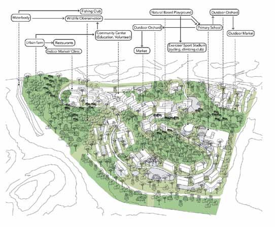
Forest Estate, Tengah Design Studio: Ten Landscape Architectural Tactics for Managing Deforestation in a High-Density Tropical City - NParks
←
→
Page content transcription
If your browser does not render page correctly, please read the page content below
park s & la n d sc a p e s

Forest Estate, Tengah Design Studio:
Ten Landscape Architectural Tactics
for Managing Deforestation in a
High-Density Tropical City
Text by Hwang Yun Hye and Feng Yuanqiu
Images as credited

                                         S
                                                econdary forests in Singapore are often            comprehensive understanding of related theories in
                                                viewed     as    temporary    and     transitory   various fields as well as its relative independence
                                                landscapes awaiting development. Based on          from commercial concerns.
                                         land use designated in the Urban Redevelopment
                                         Authority (URA) Master Plan 2014, most of the
                                                                                                        Tengah forest and development plan
                                         existing secondary forests, covering a total area         In Tengah, a 720-hectare patch is one such secondary
                                         of about 4,700 hectares, could be converted               forest site awaiting development. Since the former
                                         into development land uses, such as residential,          kampung and its accompanying landscape was
                                         commercial, institution, and reserve sites, over the      phased out in the 1980s, a young secondary forest
                                         next 10–15 years. These urban forests presently           has since taken over a patch of abandoned plantation
                                         occupy a significant proportion of land: more than        land. Adjoining the 13-kilometre Tengah Nature Way,
                                         twice the total area of all parks in Singapore and        this forest patch is strategically situated between the
                                         close to half of all land currently dedicated to public   Central Catchment Nature Reserve and the Western
                                         housing.1 They perform a number of important              Catchment area. While it is currently being used
                                         functions in the socio-ecological system of the city—     as military training grounds, the fairly undisturbed
                                         biological, biophysical and even social-cultural.         greenery has become an important stopover for
                                         When developing forested sites, it is important to        wildlife moving between more established nature
                                         take this into account and manage long-term socio-        areas. The site is also regularly utilised by some
                                         ecological consequences.                                  members of the community. Along the 1.7 kilometre
                                               In response to the issue of secondary forest        open canal diagonally cutting through the area,
                                         loss, we set up and led the Forest Estate studio as       people can be seen exercising, strolling, jogging,
                                         part of a course module at the National University        and cycling. Sporadic informal “farms”, “home
                                         of Singapore as a platform for design instructors,        gardens”, and agricultural remnants can also be
                                         students, practitioners and other professionals           spotted along the canal’s length, a vestige of the old
                                         to collaboratively investigate a common issue.            kampung life that once thrived in the area.
                                         Students from the architecture and landscape                    The forest patch is bounded by large-
                                         architecture programmes took part in this 14-week         scale transportation infrastructure, making cross-
                                         long module which began in August 2015. In this           boundary connectivity a challenge. It is also
                                         form, the studio is “a forum for speculative ideas        surrounded by three residential towns, Jurong,
                                         taken through to a degree of resolution”, valuable        Bukit Batok, and Choa Chu Kang, which consist of
                                         not just as a pedagogical tool, but also as a setting     high-rise Housing Development Board (HDB) flats,
                                         for landscape architecture research.2 The academic        institutions, industrial and commercial buildings,
                                         design studio can facilitate the generation of            and several new development plots. According
                                         systemic design strategies due to its emphasis on         to the 2014 URA Master Plan, the Tengah patch is
46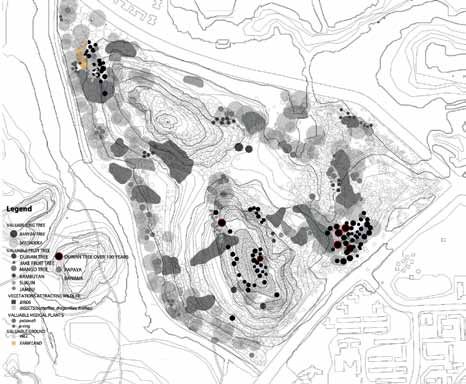
CI TYGRE E N #1 2

                                                                                                      addressing a specific issue. We then identified 10
                                                                                                      landscape architectural tactics that could be further
                                                                                                      examined in real-world scenarios.
1                                                2
                                                                                                                           1. Site-specific design
                                                                                                      The     first   quarter    of    the       studio   focused      on
                                                                                                      understanding the geographical characteristics,
                                                                                                      locality and reality of the assigned sites. Students
                                                                                                      were asked to collect data and maps related to the
                                                                                                      site including landform, demographic information,
                                                                                                      history, vegetation, microclimate, built features, and
                                                                                                      future plans. They also made intensive field surveys
                                                                                                      which     included      on-site       measurement,          species
                                                 3                                                    identification, surveys, key informant interviews,
                                                                                                      site observation, photographic documentation, and
                                               expected to be developed into a new town serving       drawings. These enabled them to layer additional
                                               mainly residential and business functions. Massive     information upon the site.
                                               construction and earthworks are slated to begin in
                                               October 2015, and a new railway network, Jurong
                                                                                                                            2. Ecological design
                                               Region Line, will be built to serve the area.          We looked to the field of urban ecology to provide
                                                     How can we compensate for the potential          guidelines      and     tenets       for   formulating      design
                                               socio-ecological impacts of deforestation while        proposals. Students looked at a set of ecological
                                               meeting the increasing commercial and housing          urbanism concepts and their design implications
                                               demands? Should the woodland be largely conserved      proposed        by    Anne      W.     Spirn. 3     To    gain   an
                                               or could it be developed in an environmentally         understanding of key issues in urban ecology, they
                                               responsible fashion? Beyond simply preserving the      also reviewed “Urban ecology: Science of cities”
                                               site, can novel design prototypes infusing greater     by Richard Forman. 4 In an early exercise, students
                                               ecological functions and diversity into the urban      applied their understanding of these principles and
                                               context be proposed? How can design improve            issues to the tropical city context as well as the
                                               well-being and promote a stewardship ethic in city     studied area by creating maps that expose various
                                               dwellers by bringing nature closer to everyday life?   issues in the urban ecosystem.
    1. Overview of Tengah forest from a        There are few clear or immediate answers to these
    resident’s home (Photo: Feng Yuanqiu).
                                               important questions that we seek to address through
                                                                                                                           3. Multiscalar design
    2. Tengah forest canal (Photo:
    Feng Yuanqiu).                             the design studio.                                     A     multiscalar       design        approach           recognises
    3. Informal farming activities in Tengah                                                          that ecosystems are nested both spatially and
    (Photo: Su Yuting).                                             Approaches                        temporally, and design decisions made at one
    4. A satellite image from Google Map
    shows the forest patch (Image:             Four approaches to address socio-cultural and          planning scale will impact many. Research and
    Google Maps).                              ecological concerns in developing Tengah are           design considerations across multiple scales such
    5. Plans for land use development at
    Tengah (Image: Urban Redevelopment         emphasised in this studio. Using these approaches,     as island-wide, neighbourhood, and landscape
    Authority Master Plan 2014).               seven projects were produced in the studio, each       detail, are taken into consideration. For example,

4                                                                                  5

                                                                                                                                                                       47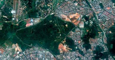
park s & la n d sc a p e s                              Forest Es tate, Tengah Design St u d io: Ten Land scape Archi t ect ural
                                                            Tactic s for Managing Deforestation in a High-Densit y Tropi c al C i t y

                                 to address issues of biodiversity, design decisions
                                                                                                     Tactics for Tengah forest estate
                                 could be evaluated at the landscape scale to               Given that the large majority of the plot has been
                                 examine broad habitat connectivity with other large        slated for housing developments, most of the
                                 green patches. Neighbourhood and point scales              studio’s projects have focused on the planning and
                                 were examined for more detailed considerations             design of residential neighbourhoods in response
                                 such as microclimate and species selection. We             to the secondary forest context. Current public
                                 also explored temporal scales such as how the              housing design approaches are rooted in Vitruvian
                                 proposal may morph and impact the adjacent                 ideals of architectural design, and the Housing
                                 landscape over time.                                       and   Development      Board      landscape   guidelines
                                                                                            prescribe a number of landscape design principles,
                                               4. Multifunctional design                    neatly   categorised     under     “community-friendly”,
                                 Multifunctional landscapes that have economic,             “environmentally-friendly”        and     “aesthetically-
                                 cultural and ecological functions are key to achieving     pleasing”.6 In the Forest Estate studio, participants
                                 sustainable landscapes. 5 Students were encouraged         questioned    these    distinctions     between     social,
                                 to produce solutions that will simultaneously address      ecological   and      aesthetic    considerations     and
                                 multiple concerns. For instance, road infrastructure       proposed a number of tactics that synthesise the trio.
                                 could potentially accommodate multiple ecosystem
                                 services   beyond   its    basic   function,   including
                                                                                             1. Diversifying the intensity of development based on
                                 phytoremediation,         stormwater      management,
                                                                                                   a value mapping of the secondary forest
                                 microclimate amelioration, habitat provision, and          While design guidelines mention the importance
                                 socio-cultural services.                                   of designing for context and existing conditions, in
                                                                                            practice this is often translated to conserving mature

6

    48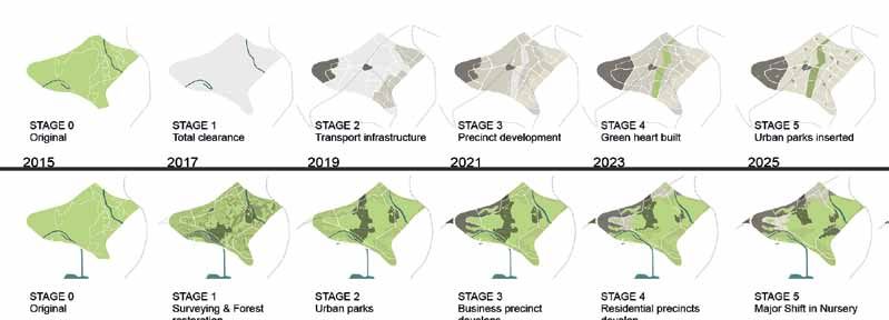
CI TYGRE E N #1 2
7
8 9
tree specimens. We suggest that more in-depth be regarded as a resource for development. Top
study and understanding of context is needed soil, for example, is highly valuable in tropical
when developing secondary forest sites. In the environments and should be collected to be reused.
Forest Estate studio, detailed mappings of habitat Apart from conserving mature trees, valuable
types, canopy cover, water bodies, topography young trees could be retained in on-site nurseries
and relationships with the surrounding urban green for replanting. Woody plant materials could also
spaces were created and overlaid to identify areas be retained on site to be used for various outdoor
6. The development process of design
tactics from studio approaches, associated of high value. Accordingly, the intensity of urban structures and furniture (see Images 8 and 9).
research activities, and design projects. developments were planned and adjusted based on
7. A value mapping of Tengah created by a
the information (see Image 7).
3. Evolving both programme and ecological values
process of overlaying. Darker areas indicate
over time
areas of higher value (Image: Pearlyn
Chang Mei Fen and Wang Chao Chao). 2. Promoting sustainable resource management by As opposed to the total and immediate replacement
8. Resource maps indicating inputs and maximising the use of site resources
outputs (Image: Pearlyn Chang Mei Fen and of site and programme when demands arise,
Wang Chao Chao). Typical development practices of ignoring the projects in Forest Estate propose a well-orchestrated
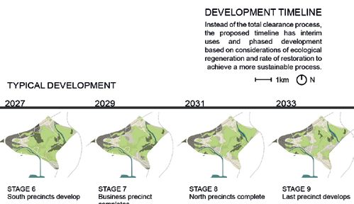
9. A quantitative comparison between secondary forest context not only results in various evolution of land use change which simultaneously
typical and proposed developments
(Image: Pearlyn Chang Mei Fen and Wang ecological impacts, but also generate large amounts allows the landscapes to mature and grow in
Chao Chao) of waste material. Instead, the existing forest could ecological value over time. Interim uses of secondary
49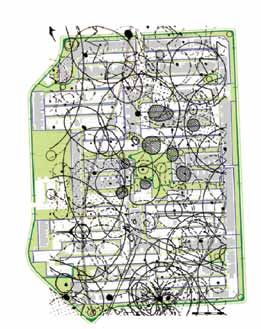
park s & la n d sc a p e s                    Forest Es tate, Tengah Design St u d io: Ten Land scape Archi t ect ural
                                                   Tactic s for Managing Deforestation in a High-Densit y Tropi c al C i t y

10

11

     10. A development phasing plan from stage
     0 to 9 over a period of 30 years (Image:
     Pearlyn Chang Mei Fen and Wang Chao
     Chao).
     11. A mapping of pedestrian movement
     through the HDB estate. The map facilitates
     the reconfiguration of human and fauna
     movements (Image: Wang Yu Qian and
     Liu Yu).
     12. Drawings of alternative road typologies      12
     to ameliorate the urban heat island effect
     (Image: Chen Wei and Tan Wenbin).
     13. A conceptual sketch of a precinct
     modelled after a forest (Image: Amanda J.
     C. and Amanda D. W.).
     50
CI TYGRE E N #1 2

     forest sites as plant nurseries and nature parks offer
     recreational space for residents living nearby and
     builds a closer relationship between urban residents
     and the adjoining forest (see Image 10).

     4. Thoughtful placement of urban infrastructure based
                   on existing site conditions
     Large scale infrastructure such as roads and
     drainage systems are critical to the functioning of
     modern cities, though their environmental impacts
     are often immense. The form and location of these
     infrastructural elements within the site should thus
     be carefully considered. For example, projects
     in Forest Estate planned and organised roads in
     reference to the topography of the site to minimise
     drastic changes to terrain and hydrology.

      5. Reconfiguring urban infrastructure typologies to
           offer more social and ecological services
     Apart     from    thoughtful      placement,     urban
     infrastructure typologies could be rethought to
     become more multifunctional. Through the use of
     alterative spatial configurations, planting palettes
     and     programming,   projects    in   Forest   Estate
     presented new road and canal typologies that
     offered recreational space, heat mitigation and
     water treatment belts, fauna movement corridors,
     and improved pedestrian accessibility (see Images
     11 and 12).

     6. Mimicking forest structures and systems to create
      a multi-layered and self-sustaining neighbourhood
     Drawing from the structure and functions of the
     tropical forest, schemes in Forest Estate sought to
     create comfortable urban microclimate, increase
     biodiversity benefits, provide urban water treatment
     services, and promote more positive human-wildlife
     relationships. One project did this by strategically
     increasing flora heterogeneity and density in the
13   residential neighbourhood’s planted areas and
     open spaces. This was done through careful studies
     of the plants’ functional traits and creating planting
     compositions that were informed by cultural and
     ethnobotanical values (see Image 13).
                                                         51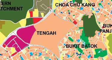
park s & la n d sc a p e s                                        Forest Es tate, Tengah Design St u d io: Ten Land scape Archi t ect ural
                                                                       Tactic s for Managing Deforestation in a High-Densit y Tropi c al C i t y

14

                                                                                                        8. Retrofitting to soften or remove major barriers in
                                                                                                                           the urban matrix
                                                                                                       Major barriers preventing wildlife movement in the
                                                                                                       urban matrix such as roads and tall buildings can
                                                                                                       be retrofitted to create a less hostile environment for
                                                                                                       fauna. For instance, vertical greening techniques,
                                                                                                       beyond their decorative role, has potential to
                                                                                                       soften these major urban barriers. In urban green
                                                                                                       spaces, increased planting density and alternative
15                                                                                                     maintenance regimes could also make human-
                                                                                                       managed spaces more welcoming to the city’s
                                                                                                       non-human denisens.

                                                                                                         9. Preserving unique landscape elements to evoke
                                                                                                            distinct neighbourhood characteristics in the
                                                                                                                         future development
                                                    7. Identifying the most strategic movement         Secondary forests, though sometimes dismissed
                                                                trajectories for fauna
                                                                                                       as “wastelands” and “wild growth”, are valuable as
                                               The patchwork replacement of urban green spaces         a unique landscape type that is now rapidly being
                                               with hardscape and urban infrastructure inevitably      replaced with hardscape and highly managed
     14. A three-dimensional sketch that       results in the fragmentation of the landscape, and      greenery, which have been criticised as being
     shows the placement of urban green        reduces connectivity for various fauna species.         monotonous and generic. Detailed surveys of
     spaces which create strategic movement
                                               Where   development     has   already    left   major   the secondary forest unveils a number of distinct
     trajectories to soften urban barriers
     (Image: Wu Yu-Chen and Pu Wenjun).        green areas disconnected, strategic movement            landscape elements—from tree covered hills and
     15. A mapping of unique landscape         trajectories through the development could be           natural streams to patches of old durian orchards
     features and elements in Tengah (Image:
     Zhang Qingqing and Su Yuting).
                                               identified for specific ecological guilds. Based on     intermixed with pioneering forest species. By
     16. Designers can develop a sense of      available space, current usage, and disruptiveness      preserving these landscape elements in the future
     place by integrating everyday life in     of existing urban barriers, designers can determine     development, a distinctive neighbourhood could
     the residential neighbourhood with the
     landscape (Image: Zhang Qingqing and      which species may be served through various             be created without using contrived designs (see
     Su Yuting).                               potential movement corridors (see Image 14).            Image 15).
     52
CI TYGRE E N #1 2

                                                      16

References
1 Tan, P. Y., Feng, Y., & Hwang, Y. H.,
"Deforestation in a Tropical Compact City
Part A: Understanding its Socio-ecological
Impacts", Journal of Smart and Sustainable
Built Environment (Accepted), 2015.
2 Helen Armstrong, "Design studios
as research: an emerging paradigm for
landscape architecture," Landscape Review
5 (1999), 5–25.
3 Anne W. Spirn, Ecological Urbanism:
A Framework for the Design of Resilient
Cities, 2011, Retrieved from http://
www.annewhistonspirn.com/pdf/Spirn-
                                                      10. Integrating landscape as part of everyday
EcoUrbanism-2012.pdf.
4 Richard Forman, "Urban ecology: Science           neighbourhood activities to create a greater sense
of cities," (New York: Cambridge University                              of place                                                  Conclusion
Press, 2014).
5 Sarah T. Lovell and John R. Taylor,          The “placelessness” of modern cities is a problem               We hope that these proposed tactics expand the
"Supplying urban ecosystem services            often       commented    upon   by    intellectuals    from     range of design approaches currently available in
through multifunctional green infrastructure
in the United States," Landscape Ecology 28    various disciplines. Yet, creating a sense of place             practice. The tactics also incite greater professional
(2013), 1447–1463, doi:10.1007/s10980-         is a tall order that cannot be instantly achieved               discourse   on    the   potential   leadership    role
013-9912-y.                                    through design. Instead, the Forest Estate studio               landscape architects can play in the management
6 Housing and Development Board, "HDB
Landscape Guide," (Singapore: Housing and      approaches the issue by aiming to closely integrate             of deforestation in a high-density tropical city.
Development Board, 2013).                      the     visible   landscape   with   everyday      activities   Ideas generated by the academic studio have to be
                                               in     the   neighbourhood      by   identifying     unique     developed and modified in the context of economic
Acknowledgements
Much of the work here was done by the          synergies between existent landscape features and               and political realities, and tested in an iterative
student participants in the Forest Estate,     programmes such as a market with a former fruit                 and   adaptive   process   of   implementation    and
Tengah studio. Year 4 students: Chang Mei
                                               orchard or a school near a more biodiverse patch.               post-implementation monitoring. As development
Fen Pearlyn, Chen Jumin, Chen Wei, Liu Yu,
Pu Wenjun, Qian Xuanyu, Su Yuting, Tan         By designing to provide opportunities for unique                encroaches further into urban green spaces all over
Wenbin, Wang Yuqian, and Zhang Qingqing.       and positive landscape experiences to take place,               the island, a set of design tactics and guidelines
Year 3 students: Amanda Dwiyani Widodo,
Amanda Jennifer Chandra, Chia Ming Kuang,
                                               designers can facilitate the development of a strong            that closely address the secondary forest context
Neo Jasmine, Nur Afiqah Bte Agus, Wang         sense of place by leveraging on the landscape                   is imperative in managing the social and ecological
ChaoChao, and Wu Yu-Chen.                      qualities of the secondary forest (see Image 16).               consequences of their continued loss.
                                                                                                                                                                  53
You can also read