Lophelia Reef off Santa Maria di Leuca Fisheries Restricted Area - April 2021
←
→
Page content transcription
If your browser does not render page correctly, please read the page content below
Lophelia Reef off Santa Maria di Leuca
      Fisheries Restricted Area

               April 2021
GFW-2021-002-EN

Executive summary
This report is the second installment in a series of three analysis reports investigating apparent
fishing activity in all the Fisheries Restricted Areas (FRAs) listed in the General Fisheries
Commission for the Mediterranean (GFCM) Recommendation GFCM/2006/3. This
recommendation prohibits fishing activities with towed dredges and bottom trawl nets in the
following areas:

   •   The Lophelia reef off Capo Santa Maria di Leuca in international waters, off the coast of
       Italy.
   •   The Eratosthenes Seamount located in the easternmost Mediterranean Sea between
       Cyprus and the Nile Cone.
   •   The Nile delta area cold hydrocarbon seeps in Egyptian waters.

In addition, the recommendation text encourages Member States to “protect the areas from the
impact of any other activity jeopardizing the conservation of the features that characterize these
particular deep-sea habitats.” Using the best available public and open-source data, these Global
Fishing Watch reports provide interested stakeholders with an overview of apparent fishing
activity both within the boundaries and up to 10 miles outside the coordinates of these three
FRAs.

These reports aim to help interested stakeholders determine the effectiveness of the
recommendation in protecting vulnerable marine ecosystems (VMEs) and bring greater
transparency to the activities taking place in these FRAs. During the analysis of all three FRAs, we
gave particular attention to identifying additional activities including oil and gas drilling or
exploration that overlap with VMEs in these areas, in particular cold-water coral mounds.

Lophelia reef off Capo Santa Maria di Leuca Fisheries Restricted Area
This study overlaid fishing vessel tracks data, using automatic identification system (AIS) data
plus remote sensing imagery to identify vessels not broadcasting on AIS, and the locations of
observed VMEs, specifically the reported locations of cold-water coral mounds.

This multi-data overview of the Lophelia reef off Capo Santa Maria di Leuca FRA did not identify
any bottom trawling in contravention of GFCM Recommendation: GFCM/2006/3. The analysis
did, however, identify trawler activity inside a 10-mile buffer that overlapped with reported
locations of cold-water coral mounds. These VMEs are not currently protected by
Recommendation 2006/03. This whole area, which is rich in cold-water corals, could benefit from
additional protection from trawling activity either through an extension of the current GFCM
Recommendation or the application of a Specially Protected Areas of Mediterranean Importance
(SPAMI) measure.

                                                 2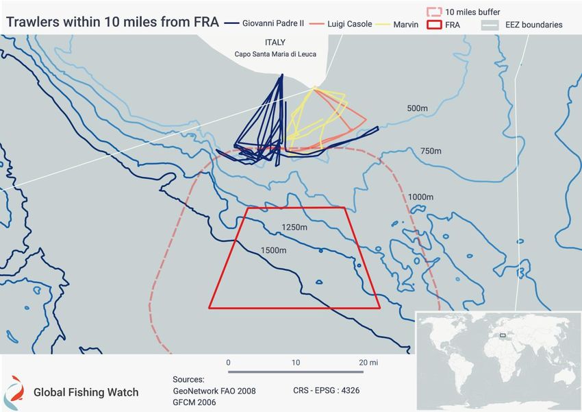
GFW-2021-002-EN

Contents
    Executive summary........................................................................................................................... 2
1      Background.................................................................................................................................... 4
    1.1 GFCM Fisheries Restricted Areas ............................................................................................ 4
    1.2 Cold-water coral mounds.......................................................................................................... 5
2      Vessel track analysis: AIS data .................................................................................................... 7
    2.1 Vessels detected inside the FRA using AIS ............................................................................. 9
    2.2 Vessels detected within a 10-mile buffer area ......................................................................10
    2.3 Trawling activity detected close to cold-water coral mounds .............................................13
3      Remote sensing: synthetic aperture radar imagery ..................................................................14
4      Key findings .................................................................................................................................16
5      Conclusions .................................................................................................................................17
6      Recommendations to GFCM Member States ...........................................................................18
Annex: Analysis methodologies ........................................................................................................19
    AIS analysis-based methods ..........................................................................................................19
    SAR analysis-based methods ........................................................................................................19

GLOBAL FISHING WATCH ANALYSIS: Global Fishing Watch is an international nonprofit organization dedicated to
advancing ocean governance through increased transparency of human activity at sea. By creating and publicly sharing
map visualizations, data and analysis tools, we aim to enable scientific research and transform the way our ocean is
managed. Global Fishing Watch processes a global database of vessel global positioning system positions from AIS
data as well as from satellite imagery to highlight apparent fishing activity in the world's oceans.

The analysis was performed using data gathered from vessels broadcasting an AIS signal, using a timeframe set from
January 2018 to August 2020. which was then compared to synthetic-aperture radar (SAR) data from March 2019 to
October 2020.

DISCLAIMER: Any and all references to “fishing” should be understood in the context of Global Fishing Watch’s fishing
detection algorithm, which is a best effort to determine “apparent fishing effort” based on data from the automatic
identification system (AIS) collected via satellites and terrestrial receivers. As AIS data varies in completeness,
accuracy and quality, it is possible that some fishing effort is not identified and conversely, that some fishing effort
identified is not fishing. For these reasons, Global Fishing Watch qualifies all designations of vessel fishing effort,
including synonyms of the term “fishing effort,” such as “fishing” or “fishing activity,” as “apparent,” rather than certain.
Any/all Global Fishing Watch information about “apparent fishing effort” should be considered an estimate and must
be relied upon solely at your own risk. Global Fishing Watch is taking steps to make sure fishing effort designations are
as accurate as possible.

                                                                          3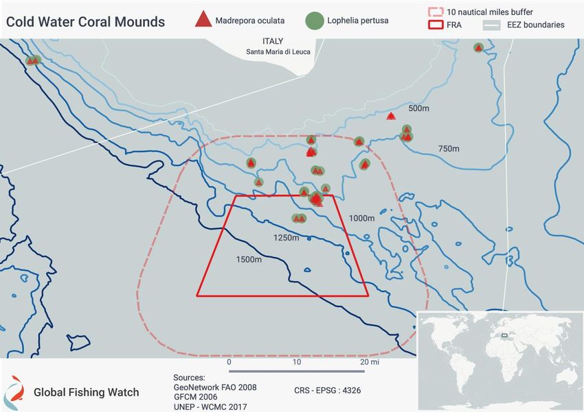
GFW-2021-002-EN
1 Background
1.1 GFCM Fisheries Restricted Areas
The Lophelia reef off Capo Santa Maria di Leuca Fishery Restricted Area (Lophelia reef FRA) is
located in GFCM subarea 19, referred to as the Western Ionian Sea. Depth ranges in the Lophelia
reef FRA are between 500m and 1500m.
The Lophelia reef FRA was established “in order to protect the coral” that has been identified in
deep-water habitats in this region. It is located in international waters, with its geographical
boundaries set from the following coordinates: 39º 27.72’ N, 18º 10.74’ E; 39º 27.80’ N, 18º 26.68’
E; 39º 11.16’ N, 18º 04.28’ E; 39º 11.16’ N, 18º 32.58’ E.
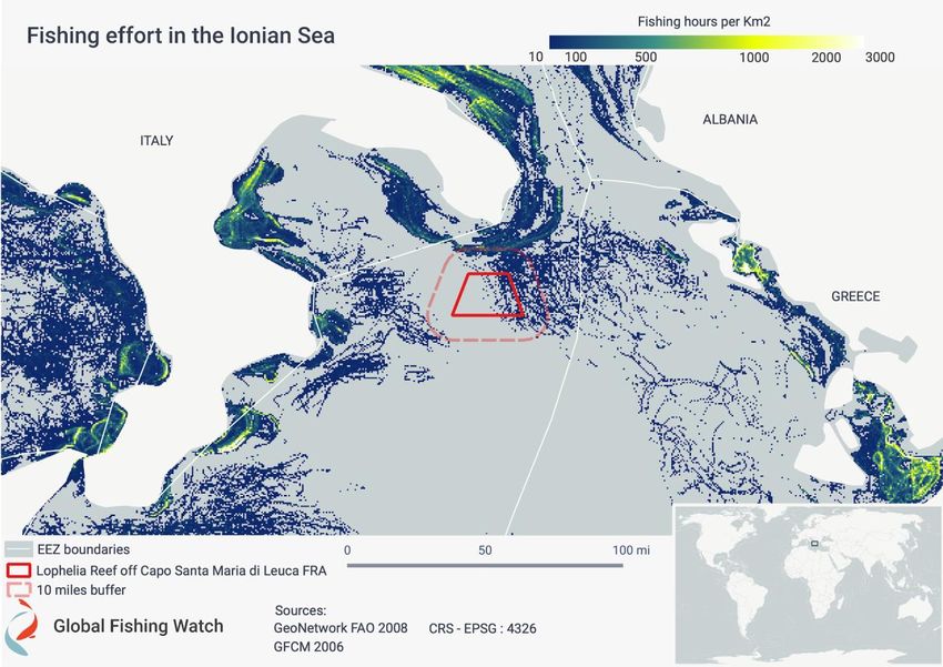
Figure 1. Level of fishing effort from AIS data represented by fishing hours per square kilometer. The red
square in the figure corresponds to the borders of the Lophelia reef FRA while the lighter red dashed box
corresponds to a 10-mile buffer area around the FRA.
4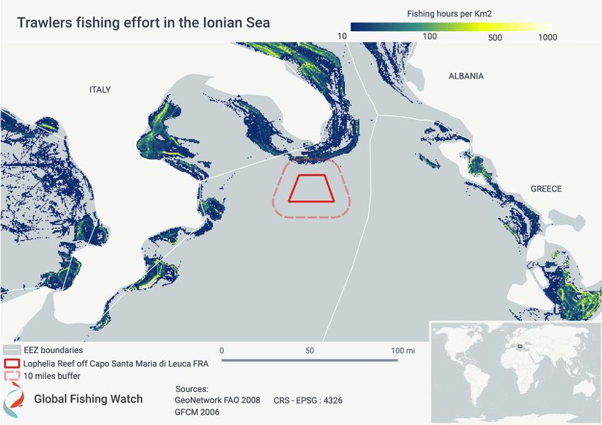
GFW-2021-002-EN

1.2 Cold-water coral mounds
The Santa Maria di Leuca reef province is “the largest occurrence of living white coral community
in the Mediterranean,” providing critical habitat for fish and other marine life.3 Academic research
over the years has recurrently highlighted Lophelia pertusa and Madrepora oculata as two of the
main species building cold-water coral reefs. These Scleractinian cold-water corals are vulnerable
to anthropogenic activities such as bottom trawling, pollution and ocean acidification.1

These organisms inhabit cold and deep-sea environments and act as ecosystem engineers.
Remotely operated underwater vehicle video surveys in this area have revealed the existence of
numerous coral mounds at a mean depth between 300m and 1,100m; however, some
occurrences have been found as deep as 1,600m.2 Studies have shown that cold-water corals, in
particular Lophelia pertusa and Madrepora oculata, can support high levels of biodiversity by
creating complex bioherms and reef frameworks.3 By releasing organic matter, they also
contribute to the biogeochemical cycles and support planktonic and benthic organisms.4 The
coral mounds are concentrated between the northern border of the FRA and up until the 500m
bathymetrical line (Figure 2).

Lophelia pertusa and Madrepora oculata are both listed as endangered in the International Union
for the Conservation of Nature Red List of Threatened Species.5 The coral mounds are
concentrated between the northern border of the FRA and the 500m bathymetrical line (Figure 2).
The location of these coral mounds came from direct observation of video and trawl surveys,3 so
it is possible that coral is present to a larger extent than described in Figure 2.

1 Bargain, A., F. Marchese, A. Savini, M. Taviani, M., and M.C. Fabri, M. C. “Santa Maria di Leuca Province (Mediterranean Sea):
Identification of suitable mounds for cold-water coral settlement using geomorphometric proxies and Maxent methods.” Frontiers in
Marine Science 4 (2017) : 338.
2
  Freiwald, A., L. Beuck, A. Rüggeberg, M. Taviani, D. Hebbeln, and R/V Meteor Cruise M70-1 Participants. “The white coral community
in the central Mediterranean Sea revealed by ROV surveys.” Oceanography 22, no. 1 (2009): 58-74..
3 Naumann, M. S., C. Orejas and C. Ferrier-Pagès. “Species-specific physiological response by the cold-water corals Lophelia pertusa

and Madrepora oculata to variations within their natural temperature range.” Deep Sea Research Part II: Topical Studies in
Oceanography 99 (2014): 36-41.
4 Wild, C., C. Mayr, L. Wehrmann, S. Schöttner, M. Naumann, F. Hoffmann and H.T. Rapp. “Organic matter release by cold water corals

and its implication for fauna–microbe interaction.” Marine Ecology Progress Series 372 (2008): 67-75.
5 https://www.iucn.org/downloads/anzothoa_fact_sheet_final_baja.pdf

                                                                 5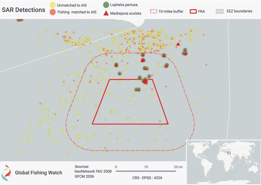
GFW-2021-002-EN

Figure 2. The location of cold-water coral mounds in the Lophelia reef FRA and its surroundings. The green
dots indicate the presence of Lophelia pertusa and the red triangles of Madrepora oculata.6 The red square
corresponds to the borders of the Lophelia reef FRA while the lighter red dashed box corresponds to a 10-
mile buffer area around it.7

6 Freiwald, A., A. Rogers, J. Hall-Spencer, J.M. Guinotte, A.J. Davies, C. Yesson, C.S. Martin and L.V. Weatherdon. Global distribution of
cold-water corals (version 4.0) (2017). Third update to the dataset in Freiwald et al. (2004) by UNEP-WCMC, in collaboration with
Andre Freiwald and John Guinotte. Cambridge, UK: UN Environment World Conservation Monitoring Centre. http://data.unep-
wcmc.org/datasets/3
7 As the location of these coral mounds came from direct observation of video and trawl surveys, it is possible that coral is present to

a larger extent than that described in Figure 2.

                                                                    6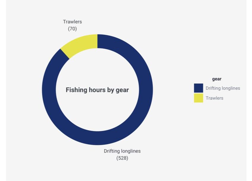
GFW-2021-002-EN

2 Vessel track analysis: AIS data
In order to estimate fishing vessel activity inside the Lophelia reef FRA, we analyzed AIS data8
from vessels active in the FRA. This data was sourced from two AIS providers, SPIRE and
ORBCOMM, processed through the Global Fishing Watch platform and applied to the analysis
period, January 2018 to October 2020.9

AIS data analysis indicated relatively low activity inside the Lophelia reef FRA, with a total of 235
hours of apparent fishing10 effort between January 2018 and October 2020. Four longline vessels
were detected fishing inside the FRA and no trawling activity was detected inside the FRA. The
235 hours were conducted by four Italian longliners registered with the International Commission
for the Conservation of Atlantic Tunas (ICCAT) record of vessels11 and European Union (EU) fleet
register12 (Figure 4). Apparent fishing hours peaked in July in 2018 and 2020 and August 2019
(Figure 3) which is consistent with the tuna and swordfish season. The vessels are registered with
ICCAT as longliners, and with the EU as one otter trawler, one purse seiner and two set longliners
(Table 1). This discrepancy between the ICCAT and EU registries reflects the seasonal variation
in fishing gears used by the vessels.

In the ICCAT record of vessels, all four vessels were specifically registered to fish for albacore
tuna (Thunnus alalunga) and Mediterrenean swordfish (Xiphias gladius). The 235 apparent fishing
hours detected by the analysis were conducted within the open seasons set out by ICCAT
Recommendation 16-05, which prohibits the capture of Mediterranean swordfish from October
to December and from February to the end of March.13 Furthermore, tracks from these vessels
were consistent with longlining activity, suggesting these vessels were not trawling within the
FRA.

8 A system built to aid navigation and that can be used to track vessels with an AIS transmitter onboard.
9 A more detailed AIS analysis methodology can be found in the annex to this report.
10 Any and all references to “fishing” should be understood in the context of Global Fishing Watch’s fishing detection algorithm, which

is a best effort to determine “apparent fishing effort” based on AIS data collected via satellites and terrestrial receivers. As AIS data
varies in completeness, accuracy and quality, it is possible that some fishing effort is not identified and conversely, that some fishing
effort identified is not fishing. For these reasons, Global Fishing Watch qualifies all designations of vessel fishing effort, including
synonyms of the term “fishing effort,” such as “fishing” or “fishing activity,” as “apparent,” rather than certain. Any/all Global Fishing
Watch information about “apparent fishing effort” should be considered an estimate and must be relied upon solely at your own risk.
Global Fishing Watch is taking steps to make sure fishing effort designations are as accurate as possible.
11 https://www.iccat.int/en/VesselsRecord.asp

12 https://webgate.ec.europa.eu/fleet-europa

13 16-05 - Recommendation by ICCAT replacing the recommendation [13-04] and establishing a multi-annual recovery plan for

Mediterranean swordfish. https://www.iccat.int/Documents/Recs/compendiopdf-e/2016-05-e.pdf

                                                                    7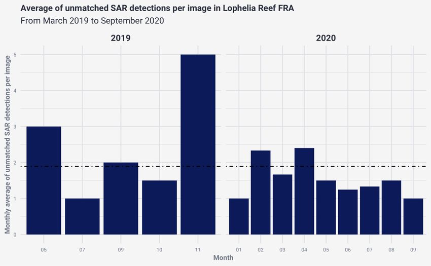
GFW-2021-002-EN

Figure 3. Total hours of fishing effort from AIS data (y axis) plotted by year and month (x axis) in the Lophelia
reef FRA. The color represents the gear responsible for the apparent fishing hours.

Figure 4. Total fishing hours from 2018 to 2020 distributed across vessels that were detected in Lophelia reef
FRA between 2018 and 2020.

                                                       8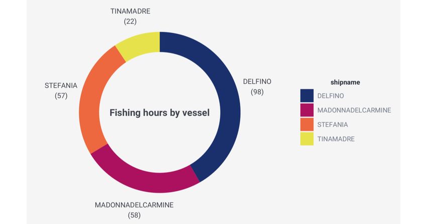
GFW-2021-002-EN

  2.1 Vessels detected inside the FRA using AIS
  The vessel tracks of the TINA MADRE were reviewed as the vessel is listed in the EU fleet register
  as an otter bottom trawler14 (as well as a non-specified longliner with ICCAT). The track analysis
  revealed that the TINA MADRE entered the FRA on June 19, 2020 and exited on June 20, 2020. It
  was recorded fishing for approximately 15 hours during this time frame, and 22 hours in total
  during the whole analysis period (see Table 1). The tracks of the vessel from June 18– 21 were
  reviewed, as well as images15 of the vessel. Both indicated that it was unlikely to be trawling within
  the FRA; the predicted fishing gear used was drifting longlines.

                                                        Gear in Gear in            Secondary
                                                                                                          ICCAT                Fishing
Vessel name        CRS        IRCS         MMSI         Neural EU fleet            gear in EU
                                                                                                       authorization         hours in FRA
                                                         Net16 register          fleet register

                 ITA0000                                                                              Longliner (type
 DELFINO                       IOIF    247141070          LLD           LLS            LHP                                          98
                  18798                                                                               not specified)

MADONNA
                 ITA0000                                                                              Longliner (type
  DEL                    IQLY          247130410          LLD           PS             LLS                                          58
                  18275                                                                               not specified)
CARMINE

                 ITA0000                                                                              Longliner (type
 STEFANIA                IJYQ          247141650          LLD           LLS            LHP                                          57
                  03343                                                                               not specified)

                 ITA0000                                                                              Longliner (type
TINA MADRE               INCO2 247134090                  LLD           OTB            LLS                                          22
                  29154                                                                               not specified)

  Table 1. Information on all vessels that were fishing within the Lophelia reef FRA.

  14 http://www.fao.org/fishery/geartype/306/en
  15 https://www.vesselfinder.com/it/ship-photos/468574
  16 The Neural Net is the output of the Global Fishing Watch fishing algorithm that predicts a vessels gear type based on its AIS track.

                                                                    9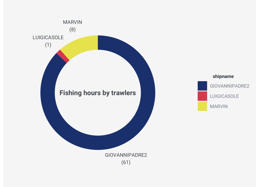
GFW-2021-002-EN

2.2 Vessels detected within a 10-mile buffer area
To understand the level of fishing activity outside the FRA boundaries, Global Fishing Watch
extended the AIS analysis to within a 10-mile buffer area around the FRA using the same time
period (January 2018 – October 2020).

Most of the activity within this area was conducted by drifting longliners (528 apparent fishing
hours out of the total 598). Fishing effort by trawlers appeared to be concentrated to the north of
the FRA border and closer to the coast (Figure 5).
    ● Three EU fleet registered trawlers flagged to Italy were responsible for 70 fishing hours
       within the 10-mile buffer area (Figure 6).
    ● One vessel, GIOVANNI PADRE II, was responsible for the large majority of the total
       apparent fishing within the 10-mile buffer area.17
    ● The other two trawlers detected were MARVIN18 and LUIGI CASOLE19 (Figure 7).

Figure 5. Level of fishing effort by trawlers from AIS data represented by total fishing hours per square
kilometer. The red square corresponds to the borders of the Lophelia reef FRA while the lighter red dashed
box corresponds to a 10-mile buffer area around it.

17   MMSI:247127460, CFR: ITA000019107
18   MMSI: 247103510, CFR: ITA000026368
19   MMSI: 247128990, CFR: ITA000024675

                                                   10
GFW-2021-002-EN
Figure 6. Total fishing hours distributed across gear type for vessels that were fishing within 10 miles of the
Lophelia reef FRA between 2018 and 2020.
Figure 7. Fishing hours of trawlers that were fishing within 10 miles of the Lophelia reef FRA between 2018
and 2020, distributed across the three vessels responsible.
11GFW-2021-002-EN
The depth of the FRA starts to drop from 500m, at 10 miles north of the FRA, to 1,000m where the
FRA delimitation starts. In the southern part of the FRA, the depth continues to drop to more than
1,500m. Trawling below 400m depth is expensive and requires specialized vessels that typically
target deep-water shrimp species.20 Example tracks of three trawl vessels with the most apparent
fishing hours within the 10-mile buffer area are reported in Figure 8.
Figure 8. Track of trawlers that were recorded fishing within the 10-mile buffer area of the Lophelia reef FRA.
Bathymetry is presented in meters (m).
20 Pinello, D., J. Gee, P. Accadia, E. Sabatella, S. Vitale, K. Polymeros and F. Fiorentino. “Efficiency of shallow- and deep-water trawling
in the Mediterranean and its implications for discard reduction.” Scientia Marina 82 (2018): 10.3989/scimar.04749.22A.
12GFW-2021-002-EN
2.3 Trawling activity detected close to cold-water coral mounds
Trawler activity was observed within the 10-mile buffer of the Lophelia Reef FRA for a total of 70
fishing hours between January 2018 and October 2020 and to depths of around 500m (Figure 8).
Vessel tracks of the three trawlers that accounted for most of the trawling hours in this area were
overlaid with known locations of cold-water coral mounds23 (Figure 9). The tracks of the trawlers
were analyzed and appear to show activity consistent with trawling behavior close to some of the
cold-water coral mounds found just outside the northern limits of the FRA.
Figure 9. Tracks of trawlers that were recorded fishing within 10 miles of the Lophelia reef FRA and the
location of cold-water coral mounds in the area. The green dots indicate presence of Lophelia pertusa and
the red triangles of Madrepora oculata.21 The red square corresponds to the borders of the Lophelia reef FRA
while the lighter red dashed box corresponds to a 10-mile buffer area around it.
21 Freiwald et al., “Global distribution of cold-water corals (version 4.0).”
13GFW-2021-002-EN
3 Remote sensing: synthetic aperture radar imagery
To gain a better understanding of the activity inside the Lophelia reef FRA, we used remote
sensing imagery to detect vessels that were operating in the area but not transmitting AIS.
Sentinel-1 synthetic aperture radar (SAR) imagery from the European Space Agency Copernicus
program was reviewed for the Lophelia reef FRA between March 2019 to September 2020. SAR
is a type of radar that provides two-dimensional images of a landscape. When the images are
taken over the ocean it is possible to automatically detect the presence of vessels over at least
18 miles against the surrounding sea.
Global Fishing Watch processes Sentinel-1 data globally, running a vessel detection algorithm
and matching detections with AIS data to identify vessels that are present but not broadcasting
an AIS signal. These vessels are referred to as “dark fleets” – vessels that do not publicly
broadcast their location or appear in public monitoring systems.
We used a Global Fishing Watch algorithm22 to classify pixels in the radar images that
corresponded to possible vessel detections. The algorithms also identify stationary objects, when
the same object is detected repeatedly in the exact same location.
In the Mediterranean, where the Sentinel-1 satellite captures images of the ocean approximately
every 2-3 days, SAR analysis confirmed 88 likely vessel detections within the FRA between March
2019 and September 2020 (Figure 10). The detections were scattered across the FRA with no
discernable hotspots of activity. A high number of detections was found just outside the northern
border of the 10-mile buffer area, in line with the AIS data analysis (Figure 1 and Figure 8).
For each satellite pass when an image of the area was taken, SAR analysis suggests a maximum
of five likely vessels not broadcasting on AIS inside the FRA, with an average of under two likely
vessels per image. This suggests a relatively consistent presence of a small number of vessels
inside the FRA that do not broadcast an AIS signal (Figure 11).
From the information available it is not possible to confirm the type of vessels detected by
Sentinel-1 SAR inside the FRA with no matched AIS signal. The seasonal distribution of these
“dark” vessels does not appear to match the fishing seasons identified by the AIS analysis (Figure
3) and the depth of water where the detections are observed suggests there is a low risk that
these detections are linked to bottom trawling inside the FRA.
22A variation of the algorithm described in J. Park, J. Lee, K. Seto, T. Hochberg, B.A. Wong, N.A. Miller, K. Takasaki, et al. Illuminating
dark fishing fleets in North Korea. Science Advances 6, no. 30 (2020): eabb1197.
14GFW-2021-002-EN
Figure 10. SAR detections that are unmatched to AIS data (yellow dots) and that are matched to AIS of fishing
vessels (orange dots). The red square corresponds to the borders of the Lophelia reef FRA while the lighter
red dashed box corresponds to a 10-mile buffer area around it. The green dots indicate the presence of
Lophelia pertusa and the red triangles of Madrepora oculata.23
23 Freiwald et al., “Global distribution of cold-water corals (version 4.0).”
15GFW-2021-002-EN
Figure 11. Mean monthly SAR detections per image that are unmatched to any AIS records in the Lophelia
reef FRA. The black dashed line represents the average detections per image from March 2019 to September
2020.
4 Key findings
AIS findings January 2018 – October 2020
• AIS data analysis indicated a total of 235 hours of apparent fishing effort inside the
Lophelia reef FRA between January 2018 and October 2020, carried out by four Italian
longline vessels registered with ICCAT.
• AIS analysis detected no explicit activity prohibited by Recommendation GFCM/2006/03
inside the Lophelia reef FRA, including by towed dredges or bottom-trawl nets.
• Using a 10-mile buffer area around the FRA as a reference point, Global Fishing Watch
detected trawler activity within the northern part of the buffer around the Lophelia reef
FRA, with a concentration of trawling activity closer to the coast of Italy.
• Global Fishing Watch detected likely trawling activity overlapping with the reported
location of cold-water coral mounds within the applied 10-mile buffer area. These
vulnerable marine ecosystems located in the Santa Maria di Leuca reef province are not
currently protected by Recommendation 2006/03.
16GFW-2021-002-EN
Remote sensing findings March 2019 – September 2020
● Analysis of Sentinel-1 SAR imagery taken over the Lophelia reef FRA did not identify any
hotspots of activity or patterns to suggest a risk of fishing activity inside the Lophelia reef
FRA by vessels not broadcasting on AIS.
● SAR analysis confirmed 88 likely vessel detections within the FRA between March 2019
and September 2020. The detections were scattered across the FRA with no discernable
hotspots of activity. A high number of detections were found just outside the northern
border of the 10-mile buffer area, which is in line with what emerged from AIS data
analysis.
● SAR analysis suggests that there were between one and five likely vessels not
broadcasting on AIS inside the FRA for each satellite pass, with an average of two or
fewer likely vessels per image. This suggests a relatively consistent presence of a small
number of vessels not broadcasting on AIS inside the FRA.
5 Conclusions
Cold-water corals such as Lophelia pertusa and Madrepora oculata are considered vulnerable to
anthropogenic activities such as bottom trawling, pollution and ocean acidification. Although no
trawling activity was detected using AIS data inside the current FRA boundaries, Global Fishing
Watch detected likely trawling activity overlapping the reported location of cold-water coral
mounds within the applied 10-mile FRA buffer area. These vulnerable marine ecosystems located
in the Santa Maria di Leuca reef province are not currently protected by Recommendation
2006/03. This whole area, which is rich in cold-water corals, could benefit from additional
protection from trawling activity either through an extension of the current GFCM
Recommendation or the application of a Specially Protected Areas of Mediterranean Importance
(SPAMI) measure.
This analysis is not conclusive on whether demersal fishing practices are “being avoided”, as
recommended by the GFCM Scientific Advisory Committee, or if a complete ban on fishing
activities with “towed dredges and bottom trawl nets” is being effectively applied. However, it
seeks to provide more clarity on the level of fishing activity in the FRA and the possible impact on
the VMEs that Recommendation 2006/03 was designed to protect. AIS data should be made
available for all vessels to deepen understanding of the potential impacts of fishing activities on
sensitive deep-sea habitats that the GFCM Recommendation has identified as requiring
protection.
17GFW-2021-002-EN
6 Recommendations to GFCM Member States
Recommendations to GFCM Contracting Parties and Cooperating non-Contracting Parties:
1. Increased transparency and consistency of fishing vessel information related to fishing
gear – including in the EU, GFCM and ICCAT fleet registers – would simplify monitoring
and support the implementation of Recommendation GFCM/2006/03.
2. The GFCM Scientific Advisory Committee should consider extending the protection
accorded by GFCM/2006/03 to at least 10 miles beyond the current FRA coordinates in
order to protect other VMEs located in the Santa Maria di Leuca reef province, namely the
cold-water coral mounds at 500m to 1000m depths to the north and northwest of the
current FRA boundary.
3. The GFCM should mandate vessel management system (VMS)/AIS reporting
requirements to monitor vessels authorized to conduct fishing activities within and
around FRAs.
4. All vessels 15m and above must be included in the GFCM fleet register.
5. All GFCM Contracting Parties and Cooperating non-Contracting Parties should publicly
share vessel registries, including the unique vessel identification number and gear type,
and submit this information to the GFCM.
6. In line with what is currently required by the EU, the GFCM should require that fishing
vessels above 15 meters length overall (LOA) be equipped with and continually transmit
positions via AIS.
18GFW-2021-002-EN
Annex: Analysis methodologies
AIS analysis-based methods
AIS broadcasts a ship’s position so that other ships are aware of its location, in order to avoid
collision. The International Maritime Organization (IMO) started to mandate the use of AIS on
vessels larger than 300 gross metric tons that travel internationally under the 2002 International
Convention for the Safety of Life at Sea.
The key factors that affect the completeness and accuracy of footprints derived from AIS analysis
are its use and reception. AIS must be installed and broadcast in order to be detected. AIS
reception is a measure of how likely it is for a vessel’s AIS message to be received correctly by
the existing network of satellites and terrestrial antennae placed along the world’s coastlines. In
regions of the world with high maritime traffic, AIS signals can interfere with each other, which
reduces reliable satellite reception.
A recent study24 by the UN Food and Agriculture Organization (FAO) and Global Fishing Watch
found that in Mediterranean waters, almost all EU vessels over 15 meters use AIS. However, AIS
captures mostly trawlers and purse seiners and often fails to capture other gears that are
commonly used by smaller vessels in the Mediterranean, such as gillnets or longlines. In fact,
around 50 percent of the Mediterranean fleet is made of vessels that are less than 12 meters in
length.
Besides the direct use of ICCAT and EU registries, the fishing vessels analyzed in this report were
also chosen based on the Global Fishing Watch database of fishing vessels. The fishing database
is defined in Kroodsma et al. (2018)25 and includes fishing vessels based on registry database
information or as defined by a convolutional neural network. The fishing vessel identity
information most commonly transmitted in AIS, such as name and IMO number, were used in this
analysis, while vessel flag was identified from a combination of registry and AIS transmission
records.
SAR analysis-based methods
To investigate the presence of vessels not using AIS in the Lophelia reef FRA, SAR data was
reviewed. Images were obtained from the European Space Agency (ESA) Sentinel-1 mission.
Sentinel-1 is primarily a land satellite, but the portion of sea that includes the Lophelia reef FRA is
captured every 2-3 days.
SAR sends pulses of radio waves and records the echo of each pulse, creating radar imagery of
the landscape. Objects across a landscape, for example vessels across the sea, can be
differentiated because they return signals that have different strengths. In fact, different
24 www.fao.org/documents/card/en/c/ca7012en
25 Kroodsma, D.A. et al. “Tracking the global footprint of fisheries.” Science 359 (2018): 904–908.
19GFW-2021-002-EN
roughness and electrical properties of the surface or objects on the surface will influence the
strength of the returned pulse while creating the radar imagery.
A Global Fishing Watch algorithm, which is a variation of an algorithm described in Park et al.
2020,26 was used to classify pixels of the radar images that corresponded to possible vessel
detections. The algorithm also identifies stationary objects: when the same object is detected
repeatedly in the exact same location then it will be classified as a stationary object. This included
isolating pixels that returned signals that were significantly stronger than the background ocean.
When the detections are identified they are then matched to vessels that are broadcasting AIS.
Global Fishing Watch performs this matching by producing a score that is the likelihood that a
given detection could be a given vessel in AIS, based on an analysis of how vessels move. The
most likely matches are then accepted (although, in most cases, each SAR detection matches to
only one vessel). The result is a dataset of likely vessels detected from SAR, with some matched
to fishing vessels, some matched to non-fishing vessels and some not matched to AIS. This last
group are either likely not broadcasting AIS or operating in an area with poor AIS reception.
For the purpose of our analysis the detections that are unmatched to AIS are highlighted in the
report. By looking at these detections we can understand whether the fishing activity identified
by the AIS data analysis is correct or if there are signs of vessels operating without transmitting
AIS.
26 Park et al., “Illuminating dark fishing fleets in North Korea.” Science Advances Vol. 6, no. 30 (2020): 2375-2548
20You can also read