APPLICATIONS OF SATELLITE AIS FOR ENVIRONMENTAL PROTECTION - SAFEGUARDING OUR OCEANS
←
→
Page content transcription
If your browser does not render page correctly, please read the page content below
APPLICATIONS OF
SATELLITE AIS FOR
ENVIRONMENTAL
PROTECTION
  SAFEGUARDING OUR OCEANS

                            +1 519 622 4445   |   exactearth.com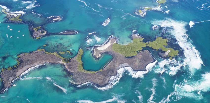
EXECUTIVE SUMMARY
exactEarth, Ltd (www.exactearth.com) exactEarth, Ltd (www.exactearth.com) is a leading organization in the field of
Global AIS vessel tracking, collecting the most comprehensive ship monitoring data and delivering the highest quality
information to customers around the world. Automatic Identification System (AIS) is a mandatory1 navigation safety
communications system under the provisions of the Safety of Life at Sea (SOLAS) Conventions which requires ships of
300 gross tons and upwards engaged on international voyages, cargo ships of 500 gross tons and upwards not engaged
on international voyages, and all passenger ships irrespective of size to be fitted with AIS. The ability to decode such
messages using a constellation of satellites has been continuously demonstrated
by exactEarth since 2010 as they have exploited big data management expertise
to deliver clear, global real-time maritime vessel tracking information to
                                                                                                   BEING ABLE
government authorities when, where and how they have needed it. The superior                       TO TRACK,
detection technology of these satellites supports the rapid build-up of verifiable                 MONITOR AND
Maritime Domain Awareness (MDA), which is now used to support 100s of
maritime applications, including environmental protection, detecting and curbing
                                                                                                   ANALYZE VESSEL
illegal fishing and monitoring marine pollution. In an ever-changing environment                   MOVEMENTS WITH
where there is a vital need for the persistent monitoring of human activity to                     CONFIDENCE
protect the world’s waters and marine life from ship disasters and illicit activity,
Satellite AIS (S-AIS) has become a very powerful tool in the delivery of MDA to a
                                                                                                   REQUIRES
variety of maritime and geospatial users in countries such as the United States,                   ACCURATE,
the United Kingdom, Finland, Australia and Canada. This white paper aims to                        TRUSTED DATA ON
highlight current applications of S-AIS data in environmental protection as well
                                                                                                   WHICH TO BASE
as potential future uses of S-AIS in this arena.
                                                                                                   THE BEST POSSIBLE
                                                                                                   DECISIONS.
THE CHALLENGES TO ENVIRONMENTAL PRO-
TECTION
With more than 90 percent of global trade being carried by sea2, the amount of industry – petrochemical, timber, cargo,
fishing - traversing the world’s waters on any given day is staggering. Although shipping is the anchor of the global
economy, this intense level of vessel traffic can leave detrimental marks on the marine environment. Petrochemical spills,
ships run aground, debris and illicit activities such as bilge dumping and overfishing, have all contributed to an ailing
ocean world and the flora, fauna and aquatic species that call it home.AIS data is critical to a new class of vessel tracking
and online chartering and trading platforms that rely on highly accurate position data for vessel voyage, fixing and
employment.

Its importance to both commercial and government users is set to increase further as pressure grows to monitor carbon
and sulfur emissions on a vessel by vessel basis. The data gathered from vessels will be used to correlate to emissions for
compliance with local and international regulations and for broader energy efficiency performance that will feed into the
relationship between shipowners and their finance providers.

1) SOLAS Ch. 5 Regulation 19 Para 2.3 www.navcen.uscg.gov/pdf/AIS/AIS_Regs_SOLAS_MTSA_FR.pdf accessed 14 Sep 12
2) IMO and the Environment 2011 http://www.imo.org/OurWork/Environment/Documents/IMO%20and%20the%20Environment%202011.pdf

                                                                    PAGE 2                        +1 519 622 4445   |   exactearth.com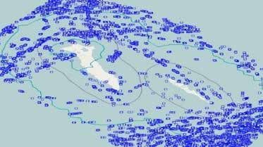
Environmental disasters such as the Rena sinking off New Zealand in 2011 and the oil spill catastrophe in the Gulf of
Mexico in 2006 shed new light on the critical need for protection of the ocean environment. The ability for ships to
transport more commodities, and potentially hazardous materials, form risks too great to ignore around ship disasters.

To help combat environmental degradation, coastal countries around the world have developed active monitoring
and enforcement programs and established marine protected areas (MPAs) to further buoy the preservation of
particularly delicate ecosystems. Despite these preventative and punitive measures, the very nature of the open sea
presents a daunting environmental protection mandate for maritime authorities. Not only must they survey massive
protection zones with limited resources, their monitoring and enforcement tasks are further challenged by the variety of
surveillance targets and range of illicit activities, as well as variable weather conditions. In short, MPAs can seem like one
big potential crime scene for illegal dumping, oil spills and illicit fishing.

AIS– GAME CHANGER
AIS transponders installed on-board vessels automatically send position reports to a land-based station, enabling
authorities to monitor vessel movements via computer displays. This information can then be used to better target and
to plan patrols.

While terrestrial AIS has enhanced the MDA for both government and commercial organisations, its range is limited to
approximately 50 nautical miles due to the curvature of the Earth. As many protected areas stretch up to 200 nautical
miles offshore, AIS fails to provide the critical beyond-the-horizon view that officials need to have to effectively monitor
their waters.

S-AIS extends vessel tracking from just 50 nautical miles to a new global picture of the world’s shipping. S-AIS
technology can accurately monitor all vessels in the vicinity of protected areas, automatically issue alerts of any
breaches to geo-fenced areas, determine traffic patterns and identify culprits of environmental offences in real time.
When coupled with historical information, it can also help trace illicit activity back to the offender, increasing the
chances to catch violators. Additionally, S-AIS data can be integrated with other geospatial tools such as radar and
optical imagery and GIS platforms, providing authorities with the real-time intelligence needed to help bring their MPAs
down to manageable size and better prevent marine disasters.

 THE exactAIS SOLUTION
 Knowing who is on the water at any given time and where they are headed is essential to maritime safety, yet it is one
 of the most challenging questions to answer with certainty.

 That critical situational awareness – the who, where and when on the water – is precisely the information that exactAIS
 provides. An information anchor for the marine environment, exactAIS utilizes a constellation of over 60 satellites to
 receive and deliver in real-time global AIS messages from even the most remote areas of the planet. Each message
 is processed and distributed to customers via a secure internet link, providing them with the Maritime Mobile Service
 Identity Number (MMSI), location, course and speed of each vessel navigating through their area of interest.

 This global view of the recognized maritime picture at any given time, for any given swath of ocean not only confirms
 detected activity, it definitively identifies undetected activity, helping authorities to demystify the enigma of ship traffic,
 build vessel profiles and create monitoring strategies that better flow with traffic patterns, all of which ultimately helps
 organizations succeed in the black versus blue battle for clean oceans.

                                                             PAGE 3                      +1 519 622 4445     |   exactearth.com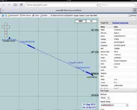
SINCE ITS
                                                                                        FOUNDATION A
HISTORY REPEATS ITSELF                                                                  DECADE AGO,
As critical and beneficial as the real-time feature of exactAIS is, so too is the
                                                                                        exactEarth HAS
ability for maritime authorities to go back in time to acquire and analyse the
historical movements and patterns of transiting vessels. Hindsight can not only         BEEN FOCUSED ON
provide key evidence for building present-day cases of illicit activity, it can prove   PROVIDING THE
instrumental in helping to develop better monitoring and navigation strategies          MOST ACCURATE
for the future.
                                                                                        AND RELIABLE AIS
exactEarth has been collecting operational AIS data since July 2010 and can             DATA AS ITS SOLE
provide datasets of all global shipping activity with its exactAIS Archive™.            MISSION.
Offering several search criteria, including ship type, date and time, ship MMSI,
country and geographical area, users can extract the specific historical data they
need and receive it from a secure server at their convenience.

With access to the Archive, customers can exploit the rich exactAIS data set to gain improved historical insight and
knowledge to better protect the marine environment. In particular, authorities can definitively identify ships in breach
of MPAs, enabling them to retroactively enforce the violation. They can establish patterns of vessel behavior and flag
suspicious ships for continued tracking to identify illegal acts such as oil dumping (with the added benefit of being able
to trace a detected spill back to the likely offender), unjust fishing or encroaching into protected areas.

INTEGRATE WITH EASE
exactEarth customers can further transform their Satellite AIS data into an integrable and actionable beacon of marine
intelligence through exactAIS® Geospatial Web Services (GWS). A customizable, on-demand data distribution model,
GWS allows users to easily access and integrate real-time ship information into existing Open Geospatial Consortium
(OGC) compliant geospatial platforms such as ESRI and Google Earth.

An open standard, GWS synthesise and transform text-based AIS messages into spatial-ready, ship-centric information
for any given vessel within a certain time slot. Functioning like a vessel information drive-thru, users access the GWS
through their existing geospatial platform, choose specific datasets on offer, such as the latest vessel information,
historical track information, or ship-density maps, and GWS then delivers the files for immediate consumption. With
GWS’ support for OGC filtering, customers can also dynamically customize data layers based on geography, time and
AIS message attributes, ensuring they only receive the exact vessel-voyage data they need.

While AIS data provides key ship details such as position, course and speed, an important distinction of GWS is that
they combine the real- time, individual messages received for a vessel and automatically convert them into a geospatial,
vessel-centric model of individual ship movements over time. Those visual and temporal tracks can then be viewed on a
map or retrieved on demand. It’s targeted exactAIS data how and when users want it, without the need for sophisticated
databases and maritime analytical systems.

                                                             PAGE 4                     +1 519 622 4445   |   exactearth.com
S-AIS FOR ENVIRONMENTAL PROTECTION
The ability to readily know the who, what and when of any transiting vessel is a critical piece of intelligence. S-AIS
provides that knowledge in real- time for any area of interest. This has been a boon for marine operations, whether it’s
combatting illegal fishing, better mapping and monitoring protected areas, or policing marine pollution.
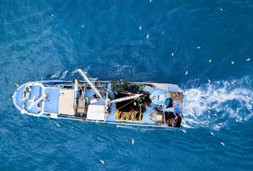
FISHING FOR OFFENDERS
Fishery licensing and inspection agencies are well aware that most of the commercial fish stocks worldwide are
overexploited, mainly due to overfishing. The United Nation’s Fisheries and Agricultural Organization (UN FAO) reports
that 53 percent of the world’s marine fishery resources are fully fished or fished to the maximum sustainable level3.
Illegal, unreported and unregulated (IUU) fishing today is recognized as a major threat to achieving sustainable fisheries.
Traditionally, vessel monitoring systems (VMS) are used for monitoring fishing activities by national and regional fishery
management agencies to prevent IUU fishing. But VMS is vulnerable to one overriding issue – crews can try to defeat
VMS by spoofing the information sent.
With S-AIS technology, vessels can no longer hide or provide false VMS reports. exactAIS data can be compared to the
vessel’s reported latitude and longitude, allowing authorities to identify spoofed position reports where illegal fishing
may be taking place. And as exactAIS extends the surveillance range beyond VMS, it can detect non-cooperative vessels
in the area – even in polar waters – and identify vessels in areas not intended for fishing. Fishery management agencies
can correlate that information with their vessel-registration systems to quickly identify unregistered vessels in fishing
waters, task patrol assets to the vicinity of these fishing vessels and catch the culprits. In addition, exactAIS can provide
hindsight for IUU activities that go unseen. The technology can help authorities identify vessel patterns and profiles and
flag ones that are suspect. They can then track those vessels used for transporting IUU catches as well as determine
historic tracks of suspected undeclared transshipment, allowing for prosecution of all vessels involved.
CASE STUDY
THE ENVIRONMENTAL JUSTICE
FOUNDATION
Using exactAIS data, the Environmental Justice Foundation (EJF) regularly
monitors fishing vessel activities in West Africa, particularly in Sierra Leone,
Gabon and Ghana, which are quite vulnerable to illegal fishing .
IUU vessels can usually be found in areas populated with legitimate fishing
vessels, and are often around a mother ship for transshipment. Knowing this
tendency, as well as other fishing patterns in this area, EJF can use satellite
AIS (S-AIS) data to quickly identify vessels engaging in suspicious activity and
catch the culprits. One such recent example of this is the case of two vessels
off the coast of Sierra Leone.
On September 18, 2013, exactAIS data placed the vessel Kum Woong 101 inside an Inshore Exclusion Zone of Sierra
Leone, off Turtle Island. Industrial vessels are banned from operating in this area. Already alerted to the Kum Woong
101’s breach into a protected area, authorities then tracked the vessel, which subsequently made a suspicious trip
to a refrigerated cargo ship, the Holland Klipper. As the exactAIS data placed the two vessels within 50 meters
of each other, and showed they were in a stationary position with no other fishing vessels approaching, the EJF
suspected there was transshipment between these two vessels on September 20, 2013. EJF investigators acted on
their suspicions the following day. They spoke to the Holland Klipper’s captain and confirmed that 4,385 exactAIS
tracking showing the transshipment cartons of cargo had been transshipped from Kum Woong 101.
3) The State of World Fisheries and Aquaculture 2010 - FAO 2011 http://www.fao.org/docrep/013/i1820e/i1820e.pdf
PAGE 5 +1 519 622 4445 | exactearth.comNO HIDING PLACE
There has been mounting evidence of deteriorating conditions and declining populations of living resources throughout
much of the world’s oceans. In an effort to combat the problem, there are a number of protected or environmentally
sensitive sea areas such as Marine Protected Areas (MPAs) or Particularly Sensitive Sea Areas (PSSAs). At issue, however,
is how authorities can properly monitor the shipping activities in these sizable zones.
Indeed with limited personnel and assets to survey the vastness of the ocean, it can be a daily challenge to determine
when and where to patrol.S-AIS technology can give authorities that direction and help them move their environmental
protection strategy from one of enforcement to one of prevention.
With S-AIS, both MPAs and PSSAs, including remote coastal regions and reefs, can be monitored for singular violations
and for trending of ship populations. exactAIS provides the ability to monitor all vessels in the vicinity of a protected
area. Using exactAIS, authorities are also able to identify those vessels that have pre-defined courses transiting through
sensitive areas to prevent unnecessary breaches. For those vessels that do not use the routing measures prescribed
by maritime agencies, authorities can use exactAIS data to generate reports for such non-compliance and then issue
corrective ship routing measures.
exactAIS data can also be used to create a report of vessels that entered protected areas without reporting to
authorities, allowing for the interception and prosecution of more violators. With exactAIS historical data, officials can
analyse maritime traffic patterns in geo-fenced areas and develop effective refinements and routing changes to ensure
vessels avoid the protected zones in the future. In short, exactAIS can be where authorities are not.
CASE STUDY
WITH SCANEX
The addition of satellite AIS (S-AIS) data can play an integral role with
many maritime environmental applications, particularly monitoring
Marine Protected Areas (MPAs) S-AIS provides an ability to monitor for
both singular violations and for shipping trend analysis. Authorities can
extend their area of surveillance into remote coastal regions, including
reefs, as well into Particularly Sensitive Sea Areas or PSSAs that are
further offshore and previously unmonitored. S-AIS provides a complete
picture for global maritime traffic, extending the analysis capability
across the world’s waters. This plays a crucial role in environmental Integrated map of the shipping situation in the
protection as demonstrated through an on-going project run by SCANEX.– Commander Island MPA zone from Oct 2011 to Oct 2012 a
satellite remote sensing company based in Russia. according to exactAIS® data
The Commander Islands are a group of sparsely-populated Russian Bering Sea islands
and the Commander Islands MPA Administration is responsible for the preservation of natural processes and phenomena of flora and fauna, species and
communities of plants and animals typical to the area and unique ecosystems of this archipelago. SCANEX, under contract with the Commander Island
MPA Administration, is implementing a satellite-monitoring project to detect illegal vessels in the 30-mile protected area around the Commander Islands,
utilising Satellite AIS data from exactEarth.
Since early 2013, shipping within this MPA zone has been continuously controlled and monitored by imaging satellites and S-AIS data with SMS and e-mail
alert servicing. exactAIS is able to distinguish three groups of illegal ships entering the area: cargo ships trying to reduce mileage and fuel consumption,
illegal fishing boats as well as cruise ships violating the boundaries of the MPA. The Commander Island MPA Administration has been able to effectively
reduce the number of offending vessels and create a dynamic black list of offenders used for control and prosecution.
PAGE 6 +1 519 622 4445 | exactearth.comFounded in 2009, exactEarth was established for the purpose of making Satellite AIS data services available
to the global maritime market. Based in Cambridge, Ontario, Canada, exactEarth leverages advanced satellite
technology to deliver vessel monitoring solutions characterized by high performance, reliability, security,
and simplicity. exactEarth is a leading organization in the field of global Automatic Identification System
vessel tracking, collecting the most comprehensive ship monitoring data and delivering the highest quality
information to customers around the world.
exactEarth Ltd. exactEarth Europe
260 Holiday Inn Drive Satellite Applications Catapult
Unit 30, Building B Electron Building, Fermi Avenue
Cambridge, Ontario Harwell (Didcot)
N3C 4E8 Oxfordshire, OX11 0QR
United Kingdom
+1 519 622 4445 +44 (0)7500 935091
©2021 exactEarth Ltd. All rights reserved.
PAGE 7 +1 519 622 4445 | exactearth.comYou can also read