LOW-IMPACT RECERTIFICATION APPLICATION - Central Oregon Siphon Power Hydroelectric Project, LIHI # 73 (FERC NO. 3571)
←
→
Page content transcription
If your browser does not render page correctly, please read the page content below
LOW-IMPACT RECERTIFICATION
       APPLICATION

Central Oregon Siphon Power Hydroelectric
          Project, LIHI # 73
             (FERC NO. 3571)

              December 2020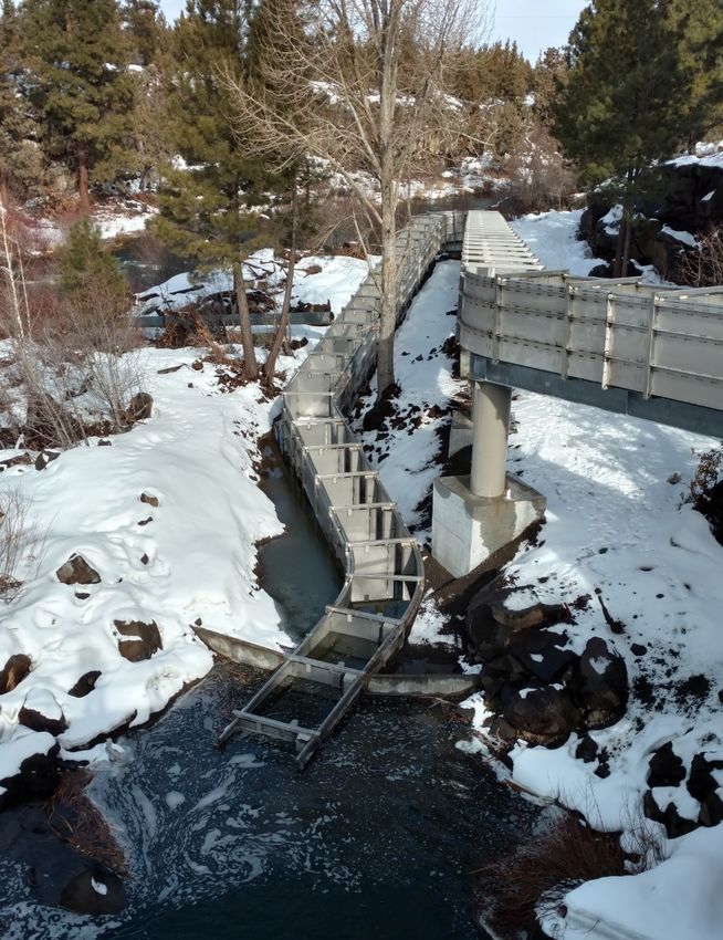
Table of Contents

1.0    FACILITY DESCRIPTION ......................................................................................................... 1
2.0    STANDARDS MATRICES ....................................................................................................... 10
3.0    SUPPORTING INFORMATION ............................................................................................... 12
  A.   Ecological Flow Regimes ........................................................................................................... 12
  B.   Water Quality .............................................................................................................................. 13
  C.   Upstream Fish Passage................................................................................................................ 14
  D.   Downstream Fish Passage and Protection................................................................................... 14
  E.   Shoreland and Watershed Protection .......................................................................................... 17
  F.   Threatened and Endangered Species Protection ......................................................................... 17
  G.   Cultural and Historic Resources Protection ................................................................................ 17
  H.   Recreational Resources ............................................................................................................... 19
4.0    FACILITY AND STAKEHOLDER CONTACTS FORMS ...................................................... 20
5.0    SWORN STATEMENT ............................................................................................................. 23
1. FACILITY DESCRIPTION
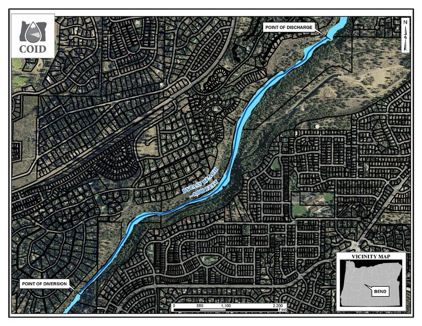
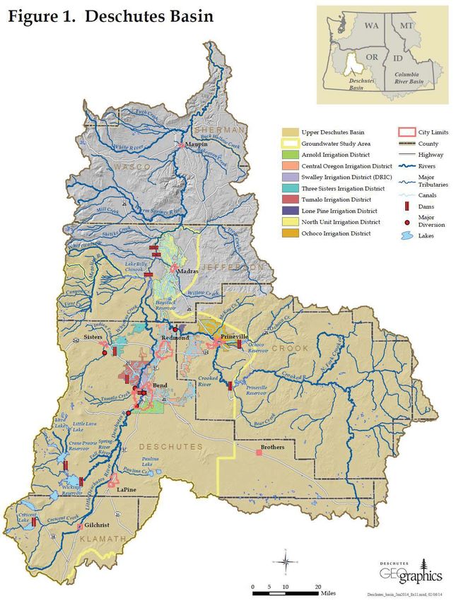
The Central Oregon Irrigation District owns and operates the Siphon Power hydropower project on a
diversion from the Deschutes River in Bend, Oregon (Figure 1). Arising from its headwaters at Little
Lava Lake, the Deschutes River flows into Crane Prairie Reservoir, then into Wickiup Reservoir. Major
tributaries above Crane Prairie include Snow, Cultus, and Deer creeks, and Cultus and Quinn rivers.
Davis and Brown’s creeks are tributaries to Wickiup Reservoir. The river reach from Wickiup Dam to
the North Canal Dam at Bend is generally referred to as the “upper” Deschutes River. Major tributaries to
the upper Deschutes include the Little Deschutes, Fall, and Spring rivers. The reach from Bend
downstream to Lake Billy Chinook is generally referred to as the “middle” Deschutes River and the
primary tributaries to the middle Deschutes are Tumalo and Whychus creeks. The Deschutes River from
the headwaters to Lake Billy Chinook is approximately 130 miles. From there, the Deschutes River flows
another 100 miles to the Columbia River.
Established in 1918, the Central Oregon Irrigation District ("COID") is a Municipal Corporation of the
State of Oregon. The irrigation system consists of two main canals: the Pilot Butte Canal, which runs
north, through Bend, Redmond and Terrebonne; and the Central Oregon Canal, which runs east, through
Bend, Alfalfa and Powell Butte. Both canals divert water from the Deschutes River. COID provides water
for about 45,000 acres within an 180,000 acre area in Central Oregon. More than 700 miles of canals
provide agricultural and industrial water to the Terrebonne, Redmond, Bend, Alfalfa and Powell Butte
areas. In addition, COID provides water to the City of Redmond and numerous subdivisions; in Bend,
many parks and schools receive water through the COID system.
FERC granted the project a 50-year license in 1987 (FERC Project No. 3571). Its two 2.75 MW units
generate on average 22,470 MWH of electricity annually.
1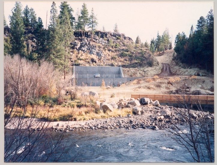
Figure 1. Project Location

Project Location

                                    2
The project consists of the use of COID’s pre-existing Central Oregon Canal system including the
Deschutes River diversion and the approximate two miles of water conveyance system downstream which
delivers water to the project penstock and powerhouse.

The diversion and water conveyance were constructed in the early 1900's and utilized an on-grade wood
flume to transport the irrigation water out of the steep, narrow river canyon where the water entered an
open canal to deliver irrigation water to lands north and east of Bend. The wood flume was replaced in
the early 1970's with a 10-foot diameter steel pipe in a double inverted siphon configuration to transport
the irrigation water from the diversion to the open canal. The siphon pipe was designed for a flow of
about 800 cubic feet per second (CFS) which is more than the irrigation demand most of the time. The
diversion modifications at that time included a louver array to guide fish entering the diversion to a return
facility to move the fish back into the river.

Downstream of the fish protection facility, water enters the 10-foot diameter double inverted siphon pipe.
About 1,200 feet downstream of the start of the open canal, a buried 9-foot diameter pipe is utilized to
deliver excess water to the powerhouse. About a mile and a quarter downstream from the diversion
structure, an underground powerhouse contains two turbines and generators. From the penstock intake to
the river downstream, there is a 135 foot drop available to drive the two turbines. At the powerhouse, the
water enters one or both of the two turbines before being discharged back to the Deschutes River. The
power generated is transported underground for about 800 feet to a small substation located out of sight
from the river where it is stepped up from 4160 volts to a nominal 69,000 volts and delivered to the power
purchaser.

The project was first certified by LIHI in 2010 and was recertified in 2015. There have been no material
changes to the project or its operations during the current LIHI term. There are two conditions with the
current certification and the project remains in compliance with these conditions.

        Condition 1. As part of their annual Compliance statement to LIHI, the Owner shall include
        electronic copies of or electronic addresses to the reports that they file with the Oregon
        Department of Fish and Wildlife related to conservation flows and tailrace fish observations,
        covering the prior four quarters.

        Condition 2. The Owner shall notify LIHI within 30 days of any changes in the level of
        mitigation enhancement funding for fish and wildlife, with particular attention to changes at or
        around January 1, 2021. (COID is currently working with ODFW on terms for the next five years
        of mitigation and enhancement funding)

                                                                                                            3
Figure 2. Siphon Powerhouse & Discharge

                                          4
Table 1. Facility Description
 Item             Information Requested                               Response (include references to
                                                                      further details)
 Name of the     Facility name (use FERC project name or other        Central Oregon Siphon Power
 Facility        legal name)                                          Hydroelectric Project
 Reason for      1. To participate in state RPS program               #3 – To participate in voluntary
 applying for    2. and specify the state and the total MW/MWh        REC market.
 LIHI                 associated with that participation (value and
 Certification        % of facility total Mw/MWh).
                 3. To participate in voluntary REC market (e.g.,
                      Green-e)
                 4. To satisfy a direct energy buyer’s purchasing
                      requirement
                 5. To satisfy the facility’s own corporate
                      sustainability goals
                 6. For the facility’s corporate marketing
                      purposes
                 7. Other (describe)
                 If applicable, amount of annual generation           22,470 KWh, 100% of annual
                 (MWh and % of total generation) for which            generation
                 RECs are currently received or are expected to be
                 received upon LIHI Certification
 Location        River name (USGS proper name)                        Deschutes River
                 Watershed name - Select region, click on the area
                 of interest until the 8-digit HUC number appears.    HUC-8 17070301
                 Then identify watershed name and HUC-8
                 number from the map at:
                 https://water.usgs.gov/wsc/map_index.html
                 Nearest town(s), county(ies), and state(s) to dam    There is no water storage associated
                                                                      with the Siphon Power Project.
                 River mile of dam above mouth                        River Mile 170.9
                 Geographic latitude of dam                           44.030304
                 Geographic longitude of dam                          -121.335186
 Facility        Application contact names (Complete the              Craig Horrell, Joshua Peed & Jenny
 Owner           Contact Form in Section B-4 also):                   Hartzell Hill
                 Facility owner company and authorized owner          Central Oregon Irrigation District
                 representative name.                                 Joshua Peed
                 For recertifications: If ownership has
                 changed since last certification, provide the
                 effective date of the change.
                 FERC licensee company name (if different from        n/a
                 owner)
 Regulatory      FERC Project Number (e.g., P-xxxxx), issuance        FERC Licensed, Project #3571
 Status          and expiration dates, or date of exemption           Issued September 29, 1987
                                                                      expires September 1, 2037
                 FERC license type (major, minor, exemption) or       Major project
                 special classification (e.g., "qualified conduit",
                 “non-jurisdictional”)

                                                                                                         5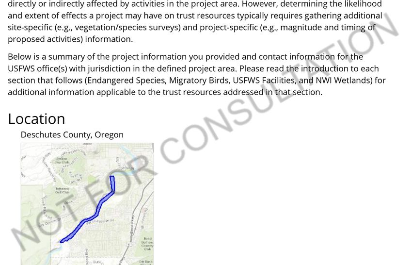
Item         Information Requested                                 Response (include references to
                                                                   further details)
             Water Quality Certificate identifier, issuance        None, waived by Oregon DEQ,
             date, and issuing agency name. Include                September 23, 1982
             information on amendments.
             Hyperlinks to key electronic records on FERC e-       FERC license
             library website or other publicly accessible data     https://lowimpacthydro.org/wp-
             repositories                                          content/uploads/2020/07/2.-Exhibit-
                                                                   I-License-3571.pdf
                                                                   License amendment 1990,
                                                                   removing article 401
                                                                   https://elibrary.ferc.gov/eLibrary/fil
                                                                   edownload?fileid=3454022

Powerhouse   Date of initial operation (past or future for pre-    October 1989
             operational applications)

             Total installed capacity (MW)                         5.5 MW
             For recertifications: Indicate if installed
             capacity has changed since last certification
             Average annual generation (MWh) and period of         22,470 MWh/year
             record used
             For recertifications: Indicate if average
             annual generation has changed since last
             certification
             Mode of operation (run-of-river, peaking,             Diversion with run of river
             pulsing, seasonal storage, diversion, etc.)           operation
             For recertifications: Indicate if mode of
             operation has changed since last certification
             Number, type, and size of turbine/generators,         Two horizontal Francis turbines
             including maximum and minimum hydraulic               rated at 200 to 600cfs each power
             capacity and maximum and minimum output of            two synchronous AC generators
             each turbine and generator unit                       producing 1,000kW at minimum
                                                                   turbine flow and 2,750kW at
                                                                   maximum.
             Trashrack clear spacing (inches) for each             3.5 inches
             trashrack
             Approach water velocity (ft/s) at each intake if      5 ft/s
             known
             Dates and types of major equipment upgrades           No changes
             For recertifications: Indicate only those since
             last certification
             Dates, purpose, and type of any recent                No changes
             operational changes
             For recertifications: Indicate only those since
             last certification
             Plans, authorization, and regulatory activities for   N/A
             any facility upgrades or license or exemption
             amendments

                                                                                                       6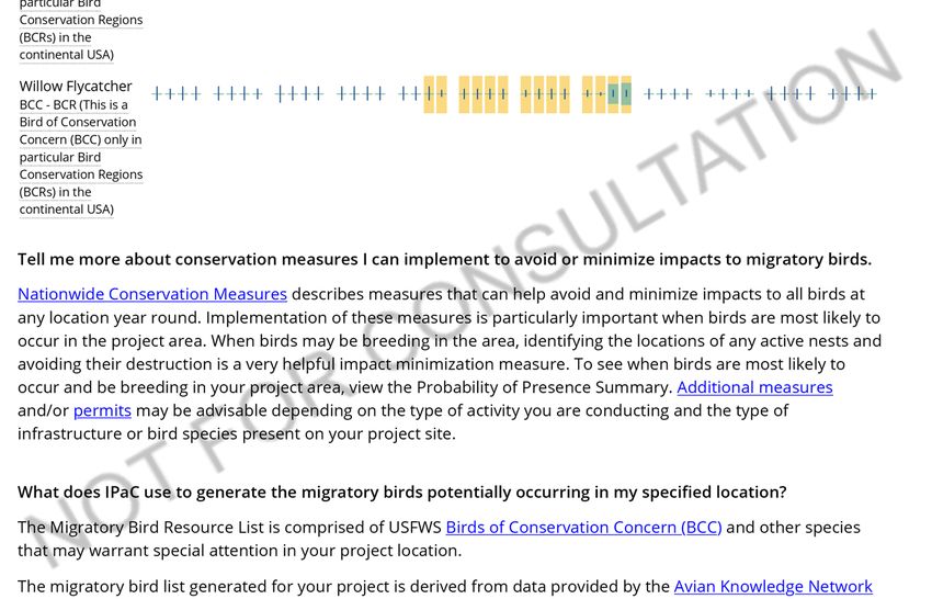
Item          Information Requested                             Response (include references to
                                                                further details)
Dam or        Date of original dam or diversion construction    The original diversion is from 1903,
Diversion     and description and dates of subsequent dam or    In the mid-70’s it was updated to its
              diversion structure modifications                 current configuration including a
                                                                first attempt at fish screening (a
                                                                louver system), in 1995 the current
                                                                fish screen was installed, and in
                                                                2013 the trash-rack was replaced
                                                                for safety and operational benefits.
              Dam or diversion structure length, height         The diversion structure is 25.5’
              including separately the height of any            wide, 157’ long, and 8.75’ tall.
              flashboards, inflatable dams, etc. and describe   Directly after the fish-screen is a set
              seasonal operation of flashboards and the like    of inflatable crest gates. Total width
                                                                of the crest gates is 24’ (four 6’
                                                                gates) with a maximum height of
                                                                3’. These are operated to keep water
                                                                height at the backside of the fish-
                                                                screen as high as possible. At
                                                                higher summer flows the crest gates
                                                                are minimally engaged and at lower
                                                                winter flows the crest gates are
                                                                raised to increase fish-screen/water
                                                                surface area.
              Spillway maximum hydraulic capacity               N/A – there is no spillway
              Length and type of each penstock and water        From the River water enters the
              conveyance structure between the impoundment      concrete diversion and fish-screen
              and powerhouse                                    area, this is 157’ long, then there is
                                                                a 100’ long concrete flume leading
                                                                to the Siphon pipe which is a 10’
                                                                diameter steel pipe above ground
                                                                for 4,400’ and underground for
                                                                1,575’ that discharges into the
                                                                1,240’ long concrete forebay and
                                                                finally enters the 8’ diameter PCCP
                                                                penstock which is 800’ long leading
                                                                to the powerhouse.
              Designated facility purposes (e.g., power,        Power supply within the existing
              navigation, flood control, water supply, etc.)    irrigation system
              Date of conduit construction and primary          n/a – not a conduit facility
Conduit       purpose of conduit
Facilities    Source water                                      n/a
Only
              Receiving water and location of discharge         n/a
Impoundment   Authorized maximum and minimum                    n/a - no impoundment
and           impoundment water surface elevations
Watershed     For recertifications: Indicate if these values
              have changed since last certification

                                                                                                    7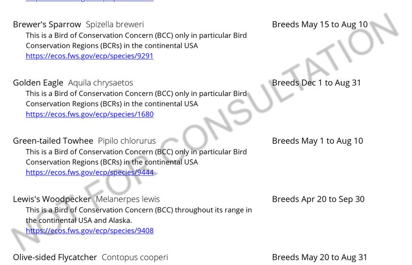
Item   Information Requested                               Response (include references to
                                                           further details)
       Normal operating elevations and normal              n/a - no impoundment
       fluctuation range
       For recertifications: Indicate if these values
       have changed since last certification
       Gross storage volume and surface area at full       n/a - no impoundment
       pool
       For recertifications: Indicate if these values
       have changed since last certification
       Usable storage volume and surface area              n/a - no impoundment
       For recertifications: Indicate if these values
       have changed since last certification
       Describe requirements related to impoundment        While there is no impoundment
       inflow and outflow, elevation restrictions (e.g.,   there is a 3 inch per hour ramping
       fluctuation limits, seasonality) up/down ramping    rate restriction at the point of
       and refill rate restrictions.                       diversion (license article 405).
       Upstream dams by name, ownership and river          Crane Prairie (No fish passage)
       mile. If FERC licensed or exempt, please provide    No Hydro
       FERC Project number of these dams. Indicate         River Mile - 8
       which upstream dams have downstream fish            Owned by Central Oregon
       passage.                                            Irrigation District (3/5), Arnold
                                                           Irrigation District (1/5) & Lone
                                                           Pine Irrigation District (1/5) and
                                                           operated by Oregon Department of
                                                           Water Resources.
                                                           Wickiup (No fish passage)
                                                           No Hydro
                                                           River Mile – 13
                                                           Owned by North Unit Irrigation
                                                           District and operated by Oregon
                                                           Department of Water Resources.

                                                                                             8
Item Information Requested Response (include references to
further details)
Downstream dams by name, ownership, river Pelton Round Butte project (3
mile and FERC number if FERC licensed or dams), PGE, RM 110.4 – 100.1
exempt. Indicate which downstream dams have FERC #2030.
upstream fish passage
North Canal Dam Complex,
Privately owned, Operated by
COID, North Unit Irrigation
District & Swalley Irrigation
District, exempt, has downstream
fish passage (partially funded via
SPP M&E funds)
Newport Hydroelectric Dam,
Mirror Pond, PacifiCorp, exempt
Tumalo Irrigation District diversion
dam at Pioneer Park
Colorado Ave, Bend dam, City of
Bend
Operating agreements with upstream or No agreements with other facilities
downstream facilities that affect water
availability and facility operation
Area of land (acres) and area of water (acres) The FERC boundary accounts for
inside FERC project boundary or under facility 22.3 acres of land.
control. Indicate locations and acres of flowage
rights versus fee-owned property.
Hydrologic Average annual flow at the dam, and period of 249,960 Acre-ft at the River
Setting record used diversion for Hydro production
Based on flows over the last 5-yrs
Average monthly flows and period of record 20,830 Acre-ft
used Based on flows over the last 5-yrs
Location and name of closest stream gaging Upstream OWRD 14064500
stations above and below the facility Deschutes River at Benham Falls
Near Bend, OR
Downstream OWRD 14070500
Deschutes River Below Bend, OR
Watershed area at the dam (in square miles). There is no dam associated with
Identify if this value is prorated from gage the Siphon Power Project
locations and provide the basis for proration
calculation.
Other facility specific hydrologic information n/a
Designated Number of zones of effect 3
Zones of Type of waterbody (river, impoundment, Zone 1: diversion
Effect bypassed reach, etc.) Zone 2: bypass reach
Zone 3: tailrace/downstream reach
9Item Information Requested Response (include references to
further details)
Upstream and downstream locations by river Zone 1: diversion RM 170.9
miles Zone 2: bypass reach RM 170.9 –
169.4
Zone 3: tailrace/downstream reach
RM 169.4
Delimiting structures or features Diversion delimits zones 1 and 2
Powerhouse discharge location
delimits zones 2 and 3
2.0 STANDARDS MATRICES
Table 2. Standard selections
3. Downstream
Zone: 1: Diversion 2: Bypass
Reach
RM 170.9 -
River Mile Extent: RM 170.9 RM 169.4
169.4
Criterion Standard Selected
A Ecological Flows 2 2 2
B Water Quality 1 1 1
C Upstream Fish Passage 1 1 1
D Downstream Fish Passage 2 2 2
E Shoreline and Watershed Protection 1 1 1
F Threatened and Endangered Species 3 3 3
G Cultural and Historic Resources 1 1 1
H Recreational Resources 3 3 3
Figure 3 below shows the Zones of Effect and the standards selected to meet the LIHI criteria are
discussed in Section 3.
10Figure 3. Zones of Effect
113.0 SUPPORTING INFORMATION
A. Ecological Flow Regimes
Criterion Standard Instructions
A 2 Agency Recommendation:
• Identify the proceeding and source, date, and specifics of the agency
recommendation applied (NOTE: there may be more than one; identify
and explain which is most environmentally protective).
• Explain the scientific or technical basis for the agency recommendation,
including methods and data used. This is required regardless of whether
the recommendation is or is not part of a Settlement Agreement.
• Explain how the recommendation relates to formal agency management
goals and objectives for fish and wildlife.
• Explain how the recommendation provides fish and wildlife protection,
mitigation and enhancement (including in-stream flows, ramping and
peaking rate conditions, and seasonal and episodic instream flow
variations).
• Explain how flows are monitored for compliance.
All zones qualify for Standard A-2.
Stream flow upstream of the project is controlled by upstream storage reservoirs. An instream flow study
was conducted at the time of licensing that showed some impacts at various flows to spawning habitat for
different species at different times of the year. However, a 400cfs continual minimum flow along with
off-site fisheries mitigation (see Section D below) was agreed to by resource agencies as protection of fish
resources in the Deschutes River.
Ramping for power generation is restricted to 3 inches per hour at the point of diversion in order to
protect the river from rapid flow reductions during turbine startup and to avoid fish stranding in the
bypass and downstream of the tailrace as flows are diverted from the river to the powerhouse.
The project diverts on average, 25% of stream flow. The amount of water diverted varies from a
minimum of about 80 cfs up to about 640 cfs and is dependent on the capacity of the siphon pipe in
excess of the irrigation demand and the minimum flow requirement. The water available for power
generation depends on irrigation flow releases from upstream storage reservoirs during the irrigation
season and typically the flow in the bypassed reach is much more than the minimum 400 cfs. During the
non-irrigation season, flow available will range from none to the maximum generation capacity of about
640 cfs. A stream gage was installed per license article 404 and flows are electronically monitored, and
quarterly streamflow reports are provided to FERC, USFWS, ODFW, and LIHI.
12B. Water Quality
Criterion Standard Instructions
B 1 Not Applicable / De Minimis Effect:
• Explain the rationale for why the facility does not alter water quality
characteristics below, around, and above the facility.
All zones qualify for Standard B-1.
Water quality certification, as required by Section 401 of the Clean Water Act, was waived for the project
by the Oregon Department of Environmental Quality (ODEQ), on September 23, 1982. Designated water
uses in the river from Bend downstream to the Pelton reregulating dam include water that is suitable for
drinking, irrigation and industrial supply; livestock watering; fish and aquatic life; wildlife and hunting;
primary and secondary contact recreation, and aesthetics. 1
The state currently categorizes the river reach downstream of the project as “good” (Deschutes River at
Lower Bridge). 2 However, the Deschutes River upstream of the project is listed as impaired for flow
modification, habitat modification, sedimentation, turbidity and some temperature exceedances. The river
downstream is listed as impaired for flow modification, temperature, and pH. 3 The entire 112.5 miles of
the river from Wickiup Dam to Lake Billy Chinook are identified as water temperature limited under
Section 303(d) of the Clean Water Act for exceeding the year-round maximum 7-DADM of 18°C for
salmon and trout rearing and migration. 4
On December 18, 2009, COID requested the Oregon Department of Environmental Quality (ODEQ) to
provide a determination relating to water quality impacts of this project. The Department conducted an
assessment of the project's water quality impacts relative to Oregon's water quality standards and the
state's Clean Water Act Section 303(d) list of impaired water bodies. Based upon this assessment, the
department determined that there was no net summertime temperature increase between the diversion and
the discharge and thus no dissolved oxygen concern.
ODEQ concluded that the project neither contributes to current 303(d) water quality impairments of the
Deschutes River, nor to violations of current state water quality standards. ODEQ’s letter, dated January
15, 2010, was provided as Exhibit B of the original LIHI application.5 Project operations have not
changed since that assessment thus the project has no effect on water quality or existing impairments.
1
p. 4-13 in
https://www.fws.gov/oregonfwo/Documents/DeschutesHCP/deisFR/DBHCP%20Entire%20Document%20August%
202019.pdf
2
https://www.oregon.gov/deq/FilterDocs/wqmColumbiaPal.pdf
3
See searchable database assessment units OR_SR_1707030104_05_102628 and OR_SR_1707030108_02_102627
at https://www.oregon.gov/deq/wq/Pages/2018-Integrated-Report.aspx
4
p. 4-7 in
https://www.fws.gov/oregonfwo/Documents/DeschutesHCP/deisFR/DBHCP%20Entire%20Document%20August%
202019.pdf
5
https://lowimpacthydro.org/wp-content/uploads/2020/07/Exhibits-B-G.pdf
13C. Upstream Fish Passage
Criterion Standard Instructions
C 1 Not Applicable / De Minimis Effect:
• Explain why the facility does not impose a barrier to upstream fish
passage in the designated zone. Typically, impoundment zones will
qualify for this standard since once above a dam and in an
impoundment, there is no facility barrier to further upstream movement.
• Document available fish distribution data and the lack of migratory fish
species in the vicinity.
• If migratory fish species have been extirpated from the area, explain
why the facility is not or was not the cause of the extirpation.
All zones quality for Standard C-1.
Migratory bull trout, steelhead, redband trout (O. mykiss gairdneri), summer/fall and spring chinook
salmon, and sockeye and kokanee salmon historically were able to migrate up the Columbia River and
into the Deschutes River as far as the natural 30-foot tall Big Falls at river mile 132 northwest of
Terrebone, OR, about 20 miles due north (downstream) of Bend. 6 Therefore, there are no migratory
species in the project vicinity and the project is not the cause of extirpation in the project vicinity.
D. Downstream Fish Passage and Protection
Criterion Standard Instructions
D 2 Agency Recommendation:
• Identify the proceeding and source, date, and specifics of the agency
recommendation applied (NOTE: there may be more than one; identify
and explain which is most environmentally protective).
• Explain the scientific or technical basis for the agency recommendation,
including methods and data used. This is required regardless of whether
the recommendation is part of a Settlement Agreement or not.
• Describe any provisions for fish passage monitoring or effectiveness
determinations that are part of the agency recommendation, and how these
are being implemented.
• Provide evidence that required passage facilities are being operated and
maintained as mandated (e.g. meets season, coordination with agencies)
D 4 Acceptable Mitigation:
• Describe the alternative mitigation measures being deployed in lieu of
downstream fish passage and/or protection strategies and provide
documentation of agency approval of the measures.
• Explain how the total benefits of the mitigation strategy equals or exceeds
the benefits that might accrue from providing downstream passage in
terms of reproductive success (e.g., numbers of fish produced, or area of
suitable habitat provided).
• Explain how the alternative mitigation measures sustain the abundance
and diversity of fish stocks in the river system.
6
A Conceptual Foundation for the Management of Native Salmonids in the Deschutes River, Jim Lichatowich,
November 1998.
14All zones qualify for Standard D-2, or alternatively, Standard D-4.
The Deschutes River in the Project area supports a coldwater fishery primarily consisting of brown and
rainbow trout. Non-migratory fish that occur in the Deschutes River 7 include mountain whitefish, several
species of sculpin, longnose and speckled daces, chiselmouth, and largescale and bridgelip sucker. Upper
watershed populations of bull trout and redband are also considered resident species. Pacific lamprey
were extirpated and are no longer present above the Pelton Round Butte project at river mile 100.
Non-native introduced species that occur in the Upper Deschutes River 8 include brook, brown and
rainbow trout, largemouth and smallmouth bass, white and black crappie, brown bullhead catfish,
bluegill, three-spined stickleback, tui and blue chub, goldfish and carp.
The project is in compliance with Mandatory Fish Passage Prescriptions of downstream passage of
riverine fish. The pre-project irrigation diversion that is also used for diversion of the water for the
hydropower project was constructed in the early 1970's and provided downstream passage using a louver
array. FERC license articles 406 and 407 required modification of the passage facility and evaluation of
the louver array and to quantify fish losses at the existing facility. The evaluation was preformed after the
facility was operational and it was determined that fish losses were unacceptable.
An evaluation of downstream fish passage options was conducted and fixed panel vertical screens with
one-eighth inch openings was proposed and agreed to by the Oregon Department of Fish and Wildlife
(ODFW) and the U. S. Fish and Wildlife Service (USFWS). The criteria established for the facility was
for juvenile fish since the evaluation did not find any fry present at the diversion. The new facility was
evaluated in cooperation with ODFW who determined that the facility met the survival criteria of ODFW
and USFWS for all fish passing through the facility, including fry.
The project is also in compliance with resource agency recommendations for riverine fish entrainment
protection, such as tailrace barriers. Tailrace barriers in the form of screens were installed across the
tailrace channel where it enters into the river. Following start of operation, ODFW indicated that they felt
that the barrier was not needed for the riverine fish present at the site due to the velocity of the water
exiting the turbines and the configuration of the water flow entering the river. COID proposed to monitor
the tailrace area for indications of fish injury and or mortality and report the results to ODFW, USFWS,
and FERC. The screens were removed, and ongoing monitoring of the site is performed and reported on a
quarterly basis.
Although pre-licensing population surveys suggested natural reproduction occurs in the project area,
limited suitable substrate was found in the 1.5-mile-long bypassed reach. As part of the licensing process,
COID performed an instream flow study that considered habitat needs for spawning and rearing of trout.
From that stemmed an agreement with the U.S. Fish and Wildlife Service (USFWS) and the Oregon
Department of Fish and Wildlife (ODFW) to maintain a year-round conservation flow of 400cfs in the
bypassed reach along with annual payments to ODFW for a mitigation and enhancement fund intended to
compensate for lost spawning habitat. COID and ODFW entered into an Agreement in March 1987 “…to
ensure no net loss of wild game fish or fish and wildlife-related recreation opportunities results from
construction and operation of the Project.” Payments for the first 30 years of commercial operation vary
from $45,000 to $95,000, and then become subject to negotiation for the remainder of the license term,
subject to a floor of $95,000, that becomes effective in 2021.
7
pp. 19-20 at https://nativefishsociety.org/assets/watershed-assets/upper-deschutes/UpperDeschutesReport.pdf
8
Ibid., pp. 26-29
15Funds are to be directed towards design and construction of mitigation and enhancement measures in the
bypassed reach and throughout the greater Deschutes basin, with a focus on the former. The USFWS is
not a party to the Agreement but gave its concurrence. Article 408 of the FERC license approved the
agreement but did not establish a role for FERC in subsequent review and approval of specific measures
to be funded and implemented.
In the early years of the mitigation and enhancement (M&E) agreement a lot of focus was on fairly
isolated habitat enhancement projects and rebuilding of riparian areas. As time went by and funds grew in
the M&E account from continued COID payments larger projects were envisioned and completed, the
most recent was the partial funding of a fish passage ladder at the North Canal Dam, see Figure 4. In the
last couple of years ODFW has felt strongly that more data from studies is needed in order to identify
areas to focus M&E efforts. The M&E committee agreed with this approach and ODFW is heading up the
research and data acquisition. ODFW is hoping to get at least five years of data and they are currently two
years into it.
Figure 4. North Canal Dam Fish Passage
16E. Shoreland and Watershed Protection
Criterion Standard Instructions
E 1 Not Applicable / De Minimis Effect:
• If there are no lands with significant ecological value associated with the
facility, document and justify this (e.g., describe the land use and land
cover within the FERC project or facility boundary).
• Document that there have been no Shoreline Management Plans or similar
protection requirements for the facility.
All zones qualify for Standard E-1.
There is little land associated with the project, just 22.3 acres. Vegetative buffers are present along the
river shorelines, which consist of the ponderosa pine shrub type. Land use in the immediate project
vicinity is mostly undeveloped although residential development and the City of Bend and its suburbs are
located nearby.
There is no shoreline management plan required for the project and there are no critical habitats for listed
species. However, the Deschutes River is designated as a Wild and Scenic River from Wikiup Dam to
0.9 miles upstream of the project’s diversion.
F. Threatened and Endangered Species Protection
Criterion Standard Instructions
F 3 Recovery Planning and Action:
• If listed species are present, document that the facility is in compliance
with relevant conditions in the species recovery plans, incidental take
permits or statements, biological opinions, habitat conservation plans, or
similar government documents.
• Document that any incidental take permits and/or biological opinions
currently in effect were designed as long-term solutions for protection of
listed species in the area.
All zones qualify for Standard F-3.
USFWS lists the following species that are or may be present in the project vicinity: the endangered gray
wolf, and the threatened yellow-billed cuckoo and Oregon spotted frog (Attachment 1). The Oregon
spotted frog became state-listed in August of 2014 and while the Oregon spotted frog is present upstream
and downstream of the project it is not present within the project area. COID is expected to have an
Incidental Take Permit from USFWS issued by December 31st, 2020.
Eight irrigation districts in the Deschutes Basin of Oregon and the City of Prineville, Oregon prepared the
Deschutes Basin Habitat Conservation Plan (HCP) to support the issuance of incidental take permits by
the US Fish and Wildlife Service (USFWS) and National Marine Fisheries Service (NMFS), under
Section 10(a)(2)(A) of the federal Endangered Species act of 1973, as amended (ESA). The Districts and
the City utilize waters of the Deschutes River and its tributaries where their activities have the potential to
incidentally harm (take) one wildlife species (Oregon spotted frog) and two fish species (steelhead trout
17and bull trout) that are currently listed as threatened under the ESA.
The Deschutes Basin HCP is the result of nearly twelve years of collaboration between irrigators, federal
and state agencies, the Confederated Tribes of the Warm Springs Reservation, cities, counties, multiple
non-governmental organizations, and the general public in the Deschutes Basin of Central Oregon. The
HCP protects habitat for three species of fish and one amphibian (steelhead trout, bull trout, sockeye
salmon, and the Oregon spotted frog) for the next 30 years, and addresses the effects of eight irrigation
districts and the City of Prineville on over 480 miles of rivers and creeks. The HCP includes adaptive
management to provide long-term certainty for irrigations, fish and frogs alike.
It provides year-round habitat for Oregon spotted frogs in Crane Prairie Reservoir, the upper Deschutes
River, Crescent Creek, and the little Deschutes River. The irrigation districts and the City of Prineville
will collectively contribute $174,000 annually to fish and wildlife habitat conservation funds in the basin.
(Over $5.2 million in restoration funds collected over 30 years to leverage grant funding and in-kind
contributions.). In 30 years, the Deschutes Basin HCP will improve winter flows from 100cfs to 400-
500cfs, and summer flows dam the 1200cfs from 1800cfs. The HCP maintain winter flows in the Crooked
River downstream of Bowman Dam of at least 50cfs and increases summer flows and provides habitat
restoration funds for Whychus, Ochoco, and McKay Creek.
G. Cultural and Historic Resources Protection
Criterion Standard Instructions
G 1 Not Applicable / De Minimis Effect:
• Document that there are no cultural or historic resources located on
facility lands that can be affected by construction or operations of the
facility; or
• Document that the facility construction and operation have not in the past,
nor currently adversely affect any cultural or historic resources that are
present on facility lands.
All Zones qualify for Standard G-1.
A cultural resources survey was completed as part of project licensing and no resources were found
within the project’s area of potential effect. The SHPO issued a finding of no effect on cultural or historic
resources.
License article 412 requires consultation with the SHPO in the event that previously undiscovered
resources are found. In that event COID would file a cultural resources management plan with the SHPO
to protect or mitigate those resources. To date no cultural resources have been found within the vicinity of
the project.
The Central Oregon Irrigation project as a whole is eligible for listing on the National Register of Historic
Places as a historic district As a result, COID is party to a programmatic agreement among US
Department of Interior, US Bureau of Reclamation, and the Oregon State Historic Preservation Office
(SHPO). 9 The agreement was based on a 2014 Memorandum of Agreement covering proposed piping
modifications in the irrigation system, a project that is not directly related to the hydro project.
9
https://www.usbr.gov/pn/programs/ea/oregon/coidpa/final.pdf
18H. Recreational Resources
Criterion Standard Instructions
H 3 Assured Accessibility:
• In lieu of existing agency recommendations and plans for recreational
uses, document the facility’s current and future commitment to
accommodate reasonable requests from recreation interests for adequate
public access for recreational use of lands and waters of the facility,
including appropriate recreational water flows and levels, without fees or
charges.
All Zones qualify for Standard H-3.
Article 410 of the license required a plan to monitor whitewater boating use in the bypassed reach.
However, in 1989 COID requested deletion of this article. During agency consultation it was agreed that
there is limited, and the rapids pose life-threatening conditions for boaters, although some advanced
boaters still occasionally use the reach. Warning signs alert boaters to the hazardous waters. In 1990,
FERC approved modification of that license article and the monitoring requirement pending any changes
in conditions in the bypassed reach or additional information suggesting that monitoring would be
appropriate.
Article 411 required COID to construct a 6,400-foot long foot riverside trail. An access trail ties into a
trail developed by the Bend Metro Park and Recreation District. COID provided an easement for the river
trail to continue about 0.75 miles upstream where a foot bridge was installed by the park district to
connect with a river trail on the opposite side of the river and extend about 1.5 miles downstream to
complete about 3 miles of loop trail along the river. Article 411 also required, and COID provides a
portable toilet at the powerhouse, and signage and trash facilities along the trail. No fees are charged for
public access.
194.0 FACILITY AND STAKEHOLDER CONTACTS FORMS
Project Owner:
Name and Title Craig Horrell – Managing Director
Company Central Oregon Irrigation District
Phone (541)548-6047
Email Address chorrell@coid.org
Mailing Address 1055 SW Lake Court, Redmond, OR 97756
Project Operator (if different from Owner):
Name and Title Joshua Peed – Director of Hydro
Company Central Oregon Irrigation District
Phone (541)548-6047
Email Address jpeed@coid.org
Mailing Address 1055 SW Lake Court, Redmond, OR 97756
Consulting Firm / Agent for LIHI Program (if applicable):
Name and Title N/A
Company
Phone
Email Address
Mailing Address
Compliance Contact (responsible for LIHI Program requirements):
Name and Title Joshua Peed
Company
Phone
Email Address
Mailing Address
Party responsible for accounts payable:
Name and Title Joshua Peed
Company
Phone
Email Address
Mailing Address
20Current and relevant state, federal, and tribal resource agency contacts with knowledge of the
facility (copy and repeat the following table as needed).
Agency Contact Area of Responsibility
Agency Name Oregon Department of Fish and Wildlife Flows
☐ Water Quality
Fish/Wildlife
☐ Watershed
T&E Species
☐ Cultural/Historic
☐ Recreation
Name and Title Brett Hodgson, Fish Biologist
Phone (541)388-6363
Email address Brett.L.Hodgson@state.or.us
Mailing Address 61374 Parrell Rd
Bend, OR 97702
Agency Contact Area of Responsibility
Agency Name U.S. Fish and Wildlife Services Flows
☐ Water Quality
Fish/Wildlife
☐ Watershed
T&E Species
☐ Cultural/Historic
☐ Recreation
Name and Title Bridget Moran, Field Supervisor
Phone (541)383-7146
Email address Bridget_moran@fws.gov
Mailing Address 63095 Deschutes Market Rd
Bend, OR 97701
21Agency Contact Area of Responsibility
Agency Name Department of Environmental Quality ☐ Flows
Water Quality
☐ Fish/Wildlife
☐ Watershed
☐ T&E Species
☐ Cultural/Historic
☐ Recreation
Name and Title Bonnie Lamb, Basin Coordinator
Phone (541)633-2027
Email address bonnie.lamb@state.or.us
Mailing Address 475 NE Bellevue Dr., Suite 110
Bend, OR 97702
Agency Contact Area of Responsibility
Organization Name Confederated Tribes of the Warm Springs Reservation ☐ Flows
☐ Water Quality
☐ Fish/Wildlife
☐ Watershed
☐ T&E Species
Cultural/Historic
☐ Recreation
Name and Title Robert “Bobby” Brunoe, Branch of Natural Resources
General Manager
Phone (541)553-2002
Email address robert.brunoe@ctwsbnr.org
Mailing Address 1233 Veterans Street
Warm Springs, OR 97761
Current stakeholder contacts that are actively engaged with the facility (copy and repeat the
following table as needed).
No Stakeholders.
225.0 SWORN STATEMENT
As an Authorized Representative of Central Oregon Irrigation District, the Undersigned attests
that the material presented in the application is true and complete.
The Undersigned acknowledges that the primary goal of the Low Impact Hydropower Institute’s
certification program is public benefit, and that the LIHI Governing Board and its agents are not
responsible for financial or other private consequences of its certification decisions.
The Undersigned further acknowledges that if LIHI Certification of the applying facility is
granted, the LIHI Certification Mark License Agreement must be executed prior to marketing the
electricity product as LIHI Certified®.
The Undersigned further agrees to hold the Low Impact Hydropower Institute, the Governing
Board and its agents harmless for any decision rendered on this or other applications, from any
consequences of disclosing or publishing any submitted certification application materials to the
public, or on any other action pursuant to the Low Impact Hydropower Institute’s certification
program.
Company Name: Central Oregon Irrigation District
Authorized Representative:
Name: Craig Horrell
Title: Managing Director
Authorized Signature: ___________________________________________
23IPaC: Explore Location https://ecos.fws.gov/ipac/location/PON6X5R2R5E6RODMV62MEPIY... 1 of 14 10/23/2020, 4:13 PM
IPaC: Explore Location   https://ecos.fws.gov/ipac/location/PON6X5R2R5E6RODMV62MEPIY...

2 of 14                                                             10/23/2020, 4:13 PM
IPaC: Explore Location   https://ecos.fws.gov/ipac/location/PON6X5R2R5E6RODMV62MEPIY...

3 of 14                                                             10/23/2020, 4:13 PM
IPaC: Explore Location   https://ecos.fws.gov/ipac/location/PON6X5R2R5E6RODMV62MEPIY...

4 of 14                                                             10/23/2020, 4:13 PM
IPaC: Explore Location   https://ecos.fws.gov/ipac/location/PON6X5R2R5E6RODMV62MEPIY...

5 of 14                                                             10/23/2020, 4:13 PM
IPaC: Explore Location   https://ecos.fws.gov/ipac/location/PON6X5R2R5E6RODMV62MEPIY...

6 of 14                                                             10/23/2020, 4:13 PM
IPaC: Explore Location   https://ecos.fws.gov/ipac/location/PON6X5R2R5E6RODMV62MEPIY...

7 of 14                                                             10/23/2020, 4:13 PM
IPaC: Explore Location   https://ecos.fws.gov/ipac/location/PON6X5R2R5E6RODMV62MEPIY...

8 of 14                                                             10/23/2020, 4:13 PM
IPaC: Explore Location   https://ecos.fws.gov/ipac/location/PON6X5R2R5E6RODMV62MEPIY...

9 of 14                                                             10/23/2020, 4:13 PM
IPaC: Explore Location   https://ecos.fws.gov/ipac/location/PON6X5R2R5E6RODMV62MEPIY...

10 of 14                                                            10/23/2020, 4:13 PM
IPaC: Explore Location   https://ecos.fws.gov/ipac/location/PON6X5R2R5E6RODMV62MEPIY...

11 of 14                                                            10/23/2020, 4:13 PM
IPaC: Explore Location   https://ecos.fws.gov/ipac/location/PON6X5R2R5E6RODMV62MEPIY...

12 of 14                                                            10/23/2020, 4:13 PM
IPaC: Explore Location   https://ecos.fws.gov/ipac/location/PON6X5R2R5E6RODMV62MEPIY...

13 of 14                                                            10/23/2020, 4:13 PM
IPaC: Explore Location   https://ecos.fws.gov/ipac/location/PON6X5R2R5E6RODMV62MEPIY...

14 of 14                                                            10/23/2020, 4:13 PM
You can also read