Making North Yorkshire's Roads Safer - Overview & Impact 2017 - Police and Crime Commissioner North Yorkshire - North Yorkshire Police and ...
←
→
Page content transcription
If your browser does not render page correctly, please read the page content below
Police and Crime
Commissioner
North Yorkshire

 Making North Yorkshire's
      Roads Safer
               Overview & Impact – 2017
Making North Yorkshire's
Roads Safer
Overview & Impact – 2017
(This report covers the period 1st January 2017 – 31st December 2017)
Contents

     Foreword                      4
     Key facts 2017                5
     Overview                      6
     Impact                        7
     Safety camera van sites       12
     Finances                      15
     District summary              16
     Since April 2015              18
     Appendix                      21

Tables
Table 1: Number of people completing driver educational courses following referral by
         North Yorkshire Police in 2017
Table 2: Deaths and serious injuries in speed-related accidents 2010-2017
Table 3: The five worst roads in North Yorkshire for collisions July 2014 – July 2017
Table 4: Top 10 most visited sites during 2017
Table 5: Top 10 sites by most violations during 2017
Table 6: Finances

Figures
Figure 1: Number of people completing speed awareness courses following referral by
          North Yorkshire Police in 2017
Figure 2: Number of people completing other driver educational courses following referral by
          North Yorkshire Police in 20717
Figure 3: Number of people killed or seriously injured on North Yorkshire's roads by year
Figure 4: Deaths and serious injuries in speed-related accidents 2010 – 2017*
Figure 5: Map of B6479
Figure 6: Average violations per hour in Shipton by Beningbrough in 2017
Figure 7: Map of Shipton by Beningbrough
Figure: 8: Safety Camera sites by category in 2017
Figure: 9: Number of safety camera van sites by district 2017
Figure 10: Number of violations recorded by safety cameras vans per district in 2017

Appendices
Appendix 1: All sites visited by safety cameras in 2017
Appendix 2: Newcastle University Report
Foreword
                                       speed related incidents in North         on North Yorkshire's roads. The
                                       Yorkshire in 2017 was the lowest         partnership approach via 95 Alive
                                       since 2010. Not all of that is down      will also continue, and I'd like to
                                       to safety camera vans, but we do         thank partners for their joint
                                       know they are life-savers, literally.    endeavours in making North
                                       In 2017 six new, more agile vehicles     Yorkshire's roads as safe as possible.
                                       were introduced by the police,
                                       taking the total number of safety
                                       cameras in North Yorkshire to 12.        Julia Mulligan
I am committed to improving                                                     Police and Crime Commissioner
road safety in North Yorkshire,        Due to their smaller size, the new       for North Yorkshire
not least because time and             vans are more suited to hard-to-
again, the public tell me it is of     reach locations, especially rural
                                       communities. Using state-of-the art
real concern.
                                       camera equipment, the vans can
And they are right. Despite            not only detect speeding drivers,
considerable progress made over        but can also identify anti-social
recent years, North Yorkshire's        driving such as seat belt offences
6,000 miles of roads are still among   and drivers using mobile phones
the most dangerous in the country.     behind the wheel.
Despite 504 deaths and serious
                                       All safety camera vans are also
injuries in 2015 reducing to 464 in
                                       equipped with Automatic Number           Chief Constable, Lisa Winward,
2017, 76 people lost their lives
                                       Plate Recognition (ANPR)                 said,
since my first report was published
                                       technology, which assists with the
in 2016.
                                       prevention and detection of cross
Improving road safety therefore will   border crime by deterring and            Road safety remains one of the key
remain a priority for both myself      disrupting travelling criminals.         strategic priorities for North
and the police. I also understand                                               Yorkshire Police. The use of a
                                       Notwithstanding the above, I know
however that this comes with a                                                  flexible and versatile safety camera
                                       some people remain suspicious of
requirement for openness and                                                    fleet is one of the options we
                                       the safety camera vans and the
transparency, which is the purpose                                              utilise in order to continually
                                       police's motive in using them due to
of this report.                                                                 improve the safety of our road
                                       the money they generate. To
Whilst we cover one year, there        address those myths head on, this        network for all road users. I, along
have been changes to North             report explains how safety cameras       with the majority of residents in
Yorkshire Police's approach over the   were used in 2017, the numbers of        North Yorkshire, believe that road
last decade; they have increased the   violations reported and the finances     safety must remain a key priority,
number and variety of safety           associated with the vans. The            our families and friends should feel
cameras, as well as introduced         information and data included in         safe on our roads, therefore there
neighbourhood-led schemes like         the report shows that more was           is no doubt that the continued use
Community Speed Watch.                 spent on running the vans than was       of mobile safety cameras, along
                                       recouped, but given their crucial        with other policing teams and
The results are encouraging as
                                       role, this is a good investment.         partners, play a vital role in keeping
independent research by academics
                                                                                our roads safe for all.
at Newcastle University shows an       Road safety will continue to be
estimated 20% reduction in             prioritised in the years ahead. I will
casualties owing specifically to the   also continue to engage with local
presence of mobile safety camera       people to understand their views
vans. To put that into some context,   and if they feel there is the right      Lisa Winward
the number of people killed in         balance of enforcement capability        Chief Constable

                                                          4
Mobile safety cameras in North Yorkshire – key facts 2017

  6    Number: Six vans at start of 2017, increased gradually throughout the year to
       twelve by December 2017, plus one motorcycle.

       Purpose: To contribute to improving road safety, casualty reduction and anti-
       social road use by monitoring traffic for speed offences, using a mobile phone whilst
       driving, failing to wear a seatbelt, dangerous driving plus many other offences.

  £    Running cost: £2,205,525

       Use: Monitored 448 different sites over more than 13,885 hours.

       Impact: Processed 80,582 road safety violations – the equivalent of
       5.8 for every hour they were in operation.

       Education: Of those violations, 43,053 led to motorists attending a speed
       awareness course.

  £    Costs Recovered: £1,941,862

       District with the highest number of violations:
       Hambleton, with 17,706.

       District with the fewest violations: Scarborough, with 3,689.

       Site with the most violations: A64 Westbound Whitwell Hill, with 4686.

       Site visited most frequently:
       A19 Shipton in Beningbrough, with 178 visits during the year.

       District with the most violations per site:
       Hambleton with an average 243 violations per site.

                                                         5
Overview
The new vehicles introduced in          seat belt, these are three of the       logger in that area) and also on
2017 are smaller and allow greater      four offences known as the 'fatal       routes known to be used by
opportunity to deploy in some of        four'. These offences, plus drink       motorcyclists, who remain one of
the more rural communities in our       driving, are the 4 main causation       our most vulnerable road users. In
County; this has led to a significant   factors of killed and serious injured   2017 we introduced sites at
increase in the number of sites         collisions.                             locations where intelligence
which now allows increased              The vehicles also address concerns      suggests other high levels of anti-
visibility in those areas.              of many communities regarding           social road use takes place, such as
In addition to the increase in the      anti-social road use by vehicles in     using a mobile phone whilst
fleet, four additional locations        local villages and towns.               driving, these are classed as
were identified for the vehicles to                                             'distraction' sites.
                                        The vans were deployed seven
deploy from. Originally all vehicles    days a week during 2017 and spent
were deployed from a single             a total of 13,885 hours monitoring
location in York, however 2017 saw      traffic, capturing 80,582 speeding         95Alive
vehicles deploying from Harrogate,      violations in that time. In addition
Skipton, Malton and Thirsk. This                                                   Formed in 2004, the 95Alive Road
                                        a large number of mobile phone,
reduces travel time from station to                                                Safety Partnership work together
                                        seat belt and other offences were
location thus providing additional                                                 to reduce the number of people
                                        also captured. The vans and
time at each site and increased                                                    killed or injured on the roads in
                                        motorcycle are deployed by Police
visibility in order to influence                                                   York and North Yorkshire.
                                        Staff as opposed to Police Officers,
traffic.                                therefore ensuring our use of the          The partnership includes
The safety camera fleet, which are      vehicles does not impact on                emergency services, local
fully liveried with high visibility     frontline policing or the number of        authorities and other agencies, and
markings, are also equipped with        warranted officers available.              their initial objective was to exceed
automatic number plate                                                             the target set the Government for
                                        Most drivers caught speeding are
recognition cameras (ANPR), these                                                  the lives that the county should
                                        offered the opportunity to attend a
cameras capture vehicle                                                            save on its road. Their aim was to
                                        speed awareness course, repeat
movements and gather intelligence                                                  save an additional 95 lives,
                                        offenders and those driving at
on vehicles travelling across the                                                  however when the campaign
                                        higher speeds will receive the offer
County. The use of ANPR cameras                                                    officially ended in March 2011, 126
                                        of a fixed penalty fine and penalty
on the safety camera vans further                                                  lives had been saved by the
                                        point on their driving licence, or a
supports the investment in our                                                     partnership.
                                        Court hearing which may result in a
fixed site ANPR infrastructure          disqualification.                          Since then, the partnership has
within North Yorkshire and the city                                                continued to work together, with
of York, bolstering our                 Cost recovery totaling £1,941,862
                                                                                   the continued aim of reducing
commitment to making our                was received by North Yorkshire
                                                                                   collisions and casualties even
communities safe from travelling        Police resulting from motorists
                                                                                   further. And not only does the
and cross border criminality. This is   attendance at driver educational
                                                                                   partnership address road safety
especially important in our rural       courses, this was used to fund the
                                                                                   concerns across the county, it is
areas where a physical presence         safety camera operation with any
                                                                                   also key in promoting road safety
and supporting ANPR technology          remainder being used for local
                                                                                   for all motorised and non-
will not only provide reassurance       road safety initiatives.
                                                                                   motorised road users
to communities but support efforts      The vans deploy to a number of
in addressing rural crime.              differing sites, these include routes
The primary purpose of the              where there is a history of Killed
vehicles is to reduce road traffic      and Seriously Injured (KSIs)
collisions by enforcing a range of      collisions, areas where
road traffic offences such as           communities have raised concerns
speeding, using a mobile phone          over speeding vehicles (validated
whilst driving, and failing to wear a   by placement of a speed data

                                                          6
Impact
The primary purpose of the safety      post safety camera deployments
camera vans is to reduce the           at those sites. Their findings
number of people who are killed        estimated a 20% reduction in
or seriously injured on the roads of   casualties owning to the
North Yorkshire. By enforcing legal    presence of mobile safety
speed limits and many other road       cameras.
traffic offences, they also
                                       Furthermore the increase in
encourage more drivers to comply
                                       the number of safety camera
with the laws of the road and
                                       sites increases visibility which
reduce incidents of anti-social
                                       in turn does address driver
driving.
                                       behavior.
In the year, safety camera vans
                                       The technology in the safety
recorded 80,582 road safety
                                       camera vans also supports the
violations of which 43,053 resulted
                                       detection of other road traffic
in offenders attending a speed
                                       offences, all of which cause danger
awareness course – more than
                                       to road users.
3,500 per month.
                                       It is not only down to the visibility
Newcastle University recently
                                       and enforcement; our presence at
carried out an evaluation of mobile
                                       many locations is met by positive
road safety cameras in North
                                       public feedback, residents
Yorkshire, this involved analysis of
                                       reassured that anti-social road use
collision data at a number of sites
                                       in their area is acknowledged and
across North Yorkshire pre and
                                       being addressed.

Table 1:Number of people completing driver educational
courses following referral by North Yorkshire Police in 2017

                                                      RIDE                  Driving 4   What’s Driving
                       Speed Awareness      Rider Intervention Developing
                                                      Experience            Change          Us?
         Jan                  3150                      0                      1              65
         Feb                  3063                      1                      1              66
        Mar                   2322                      4                      2              60
         Apr                  2635                      0                      1              69
        May                   2952                      3                      1              42
        June                  3585                      5                      1              28
         July                 4108                      3                      3              24
        Aug                   4406                      2                      0              17
        Sept                  4188                      2                      0              13
         Oct                  4356                      5                      0              16
        Nov                   4504                      5                      1              25
         Dec                  3784                      4                      0              23
       Totals                43053                      34                     11            448

                                                                 7
Figure 1: Number of people completing speed awareness courses
following referral by North Yorkshire Police in 2017

    5000
                                                                                                                      4406                                       4504
    4500                                                                                                                                         4356
                                                                                                      4108                          4188
    4000                                                                                                                                                                         3784
                                                                                       3585
                 3150          3063
                                                                        2952
    3000
                                                          2635
    2500                                     2322

    2000

    1500

    1000

     500

       0
                 Jan           Feb            Mar         Apr            May            June          July            Aug           Sept             Oct             Nov            Dec

Figure 2: Number of people completing other driver educational courses following referral by North
Yorkshire Police in 2017. (The What's Driving Us? Course figures decrease as a result in the change in driving
whilst using a mobile phone legislation in March 2017 whereby NYP no longer offer a course for such an offence)

                                                        69
70
             65               66

                                             60
60

50

                                                                        42
40

30                                                                                     28
                                                                                                   24                                                           25
                                                                                                                                                                               23
20
                                                                                                                     17                         16
                                                                                                                                  13
10
                                     4                                         5                                                       5               5
                                                                3                           3 3                                                                        4
                                         2                          1                                        2            2
0      0 1              1 1                       0 1                              1                             0            0             0               0              0
           Jan           Feb          Mar           Apr          May           June            July          Aug             Sept          Oct             Nov             Dec

            Rider Intervention on Developing Experience (RIDE)                                          Driving 4 Change                    What's Driving Us?

                                                                                               8
The number of people killed or               Figure 3: Number of people killed or seriously injured on
seriously injured on the county's            North Yorkshire's roads by year
roads each year has gone down by
over 20% between 2010 and 2017,
                                              500
as figure 2 shows.
However, while safety camera vans
                                              480
are there to reduce all types of
collisions, their particular focus is
                                              460
on speed and therefore speed-
related accidents.
                                              440
During 2017, five people died in
speed-related accidents. This was
                                              420
half the number of people who
died in such accidents the previous
                                              400
year in 2016, and the lowest figure
recorded since 2010.
                                              380

                                              360
                                                         2010   2011   2012     2013          2014    2015       2016        2017

Table 2: Deaths and serious injuries in speed-related accidents 2010 – 2017
                         2010       2011            2012        2013     2014           2015          2016           2017

  Deaths                 12             7            8           19       11             6            10              5
  Serious injury
                         66             49          63           60       50            74            67             52
   Total                 78             56          71           79       61            80            77             57

Figure 4: Deaths and serious injuries in speed-related accidents in North Yorkshire 2010 – 2017*

 90

 80           78                                    79                  80
                                                                                       77
 70                                 71                                  74
              66                                                                       67
                                    63                          61
 60                                                 60
                         56                                                                          57
 50                                                             50                                                   Deaths
                         49                                                                          52
 40                                                                                                                  Serious injury
                                                                                                                     Total
 30

 20                                                 19
 10           12                                                11                     10
                         7          8
   0
             2010       2011        2012            2013        2014    2015           2016          2017

                                                                                  *The 2017 data is provisional and requires verification

                                                                9
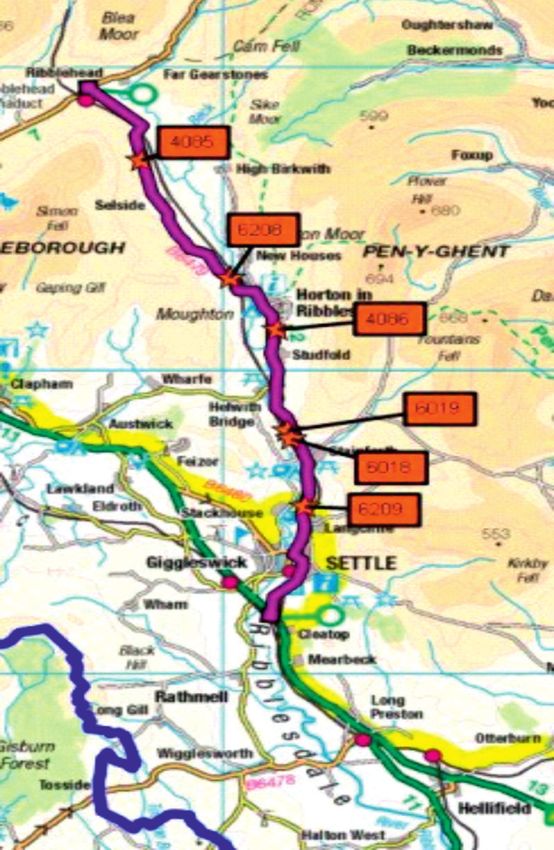
Case study: B6479
Reduction of casualties: Figure 5: Map of B6479
The B6479 is a rural and windy
route that runs from Settle to
Ribblehead, it is an identified
motorcycle route and
unfortunately has a history of
fatal and serious collisions. In a
three year period between
October 2012 and October 2015
there were four fatal and six
serious collisions on that road,
eight of these were speed
related and eight involved
motorcycles.
In October 2015 North Yorkshire
identified a number of sites
along the route which were
deemed suitable for safety
camera enforcement; these are
identified on the map.
In the period from initial
deployment in October 2015 to
the end of 2017 there have been
two serious collisions, neither of
which are classed as speed
related, one involved a
motorcycle.
In 2017 a safety camera van
deployed to this route on 340
occasions, spending 409 hours
monitoring traffic, capturing 975
speeding offences along with
mobile phone offences. In this
period there was one serious
collision which was not speed
related.
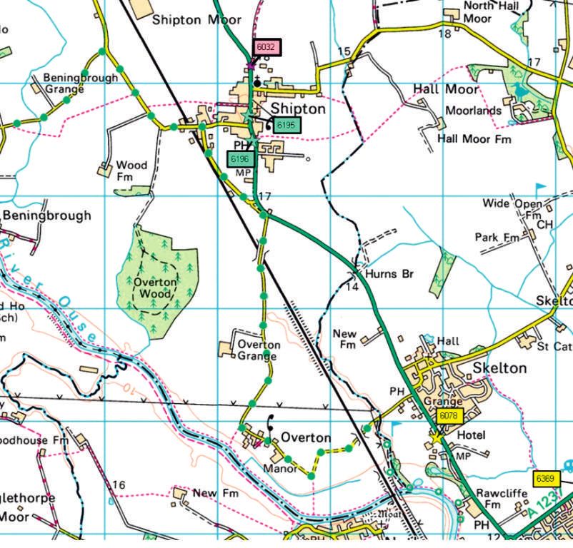
10Case study: A19 Shipton by Beningbrough
Reduction of speed: Figure 6: Average violations per hour in Shipton by Beningbrough
Shipton by Beningbrough is a in 2017
village that lies on the A19 to
the North of York. Residents 8
raised concerns over speeding 7.71
vehicles, and following the 7.5
deployment of speed data
loggers, it was found there was a
speeding issue. 7
A number of safety camera
locations were identified and 6.5 6.36
assessed at the south, centre
and north of the village. 6
5.76
Enforcement commenced in 5.5
January 2017 and this has
resulted in a decline in violations
5
captured per hour.
January June December
Feedback has been received
from local residents which Figure 7: Map of Shipton by Beningbrough
supports our enforcement
strategy in that area. Whilst
speed is reducing in Shipton by
Beningbrough our presence in
the area will continue to further
improve road safety in that
village.
11Safety camera van sites
North Yorkshire has over 6,000 ride favoured routes, whilst not enforcement is an important part
miles of road including motorway, wishing to stop this in any way it of the approach. If they find
dual and single carriageway, these is imperative we are visible at evidence of speeding, they add the
roads navigate across cities, towns these locations to influence the site to their list of locations to be
and villages through national parks manner of riding to maximise enforced if they feel that
and moors. safety. For this reason, some 57 enforcement would help tackle the
sites popular with bikers are problem. However, some sites
During 2017 safety camera vehicles
visited by safety camera vans. cannot accommodate safety
deployed at 448 locations across
camera vans and the police use
the large geographical area of Community Concern Sites
other ways of enforcing the speed
North Yorkshire; this is an increase
When a member of the public limits.
of 182 locations from those
raises a concern about the speed
deployed to in 2016. Sites of community concern are
of traffic at a particular location,
included on the list of locations to
On a number of roads where there North Yorkshire Police - through
be visited by safety camera vans.
are serious collisions a route based the 95 Alive partnership - work
During the year, there were 51
approach is adopted, where with colleagues to provide a
sites of community concern
multiple sites are identified in robust process for assessing and
included on the list.
order to maximise visibility and to dealing with such concerns. They
influence driver behaviour over the use data logging machines to Distraction sites
length of that route. At the end of monitor the speed of passing These are sites that have been
2017 there were 58 live routes vehicles over a seven day period. identified through intelligence,
across North Yorkshire. Each site is then assessed on both including feeds from Operation
Routes / Sites are selected if they the speed data captured and Spartan, where other inappropriate
meet the following criteria: collision data in that area to allow or anti-social road use is impacting
a decision to be made on what on communities. Such areas are
Routes on which there has action is most appropriate. locations where drivers regularly
been killed or seriously injured
Action may include engineering, use mobile phones, especially near
collisions. community speed watch, vulnerable road users such as
North Yorkshire Police together enforcement, education, children, other pedestrians and
with its partners in 95 Alive keep or information campaigns or a cyclists. Currently there are 27
detailed records of all collisions on combination of some. Targeted distraction sites available.
the county's roads. They record
data which categorizes the
location, severity and cause of
collisions. This information once Figure 8: Safety Camera sites by category in 2017
analysed allows safety cameras
vehicles to be deployed effectively 27
and at the times of greatest risk on 51 Community Concern
(6%) (11%)
that route. Safety camera vans visit 57
313 locations on routes where (13%) KSI
there has been a fatal or serious
collision. Motorcycle
Identified Motorcycle routes Distraction
313
Motorcyclists are over-represented (70%)
In the number of people who are
killed or seriously injured on the
county's roads. This is particularly
so because bikers from all over the
country come to North Yorkshire to
12Table 3: The five worst roads in North Yorkshire for collisions July 2014-July 2017
Road Fatal Serious
Total accidents
A64 - Leeds - York - Malton - Scarborough 10 52 62
A59 – York – Harrogate - Skipton 1 58 59
A19 – Balne Moor - Selby – York – Thirsk - Crathorne 8 46 54
A61 - Thirsk - Ripon - Harrogate 2 37 39
A1(M) Wetherby - Dishforth - Barton 2 36 38
Figure 9: Number of safety camera van sites by district 2017
100
88
90
80
72
57 64
52 49
40
40
30 26
20
10
0
te
re
le
n
on
h
k
y
ve
ug
r
lb
da
ga
hi
Yo
et
Se
ra
ds
ro
ye
ro
bl
C
bo
on
am
ar
R
ar
H
hm
H
Sc
ic
R
Figure 10: Number of violations recorded by safety camera vans per district 2017
18000 16604
16000
14000 13176
12567
12000 10777
10383
9127
10000
8000
6000
4259
3689
4000
2000
0
te
re
e
n
on
gh
k
y
al
ve
r
lb
ga
i
Yo
sh
et
u
d
Se
ra
ro
ye
ro
bl
d
C
bo
on
am
ar
R
ar
H
hm
H
Sc
ic
R
13Table 4: Top 10 most visited sites during 2017
Road Type District Violations Visits
A19 Shipton in Beningbrough KSI YORK 1102 178
A64 Westbound Whitwell Hill KSI RYEDALE 4686 167
A169 Pickering (North) KSI RYEDALE 1734 153
Rice Lane Flaxton CC RYEDALE 824 145
A59 Beamsley Hill KSI CRAVEN 1666 144
A65 Settle ByPass (north) KSI CRAVEN 767 133
A59 Blubberhouses at Kex Gill Farm KSI HARROGATE 495 132
A629 Crosshills KSI CRAVEN 956 127
A59 Benthill Farm, Beamsley KSI CRAVEN 1354 121
A59 Priors Bridge Draughton BIKE CRAVEN 424 116
Table 5: Top 10 sites by most violations during 2017
Road Type District Violations
A64 Westbound Whitwell Hill KSI RYEDALE 4686
A168 Southbound Asenby KSI HARROGATE 3328
A19 Crathorne S/Bound KSI HAMBLETON 2692
A64 Westbound at Stutton KSI SELBY 2343
A19 Northbound at Borrowby KSI HAMBLETON 2307
A64 Eastbound Bramham Moor KSI SELBY 2031
A64 Eastbound Heslington York KSI YORK 1970
A169 Pickering (North) KSI RYEDALE 1734
A59 Beamsley Hill KSI CRAVEN 1666
A19 Southbound at Knayton KSI HAMBLETON 1590
14£
Finances
The North Yorkshire safety camera Where this money went
operation is funded through cost
During 2017 cost recovery totalled
recovery resulting from drivers
£1,941,862. This contributed to the
paying to attend a driver
operating costs of the safety
educational course, there are a
camera team, this included
number of such courses available
employee costs, fleet costs,
dependant on the offence, all
supplies and services
courses are offered as an
alternative to prosecution and are
aimed to educate and address Table 6: Finances
behaviour and attitude to driving.
2017-18 Actuals
A speed awareness course is the at Dec 2017
main course offered, however
there are also courses aimed at Costs
addressing a deliberate act whilst
Employee costs £1,575,297
driving (what's driving us?), an
offence resulting from a minor lack Transport costs £39,858
of concentration (Driving 4 change)
and also aimed specifically at Supplies & services costs £546,386
motorcyclists who commit traffic
Financial costs £43,985
infringements (Rider Intervention
Developing Experience - RIDE). In £2,205,525
addition there is also an on-line
seat belt course (Your belt, Your Income
life) which is aimed at those who Fees driving services £1,673,668
fail to wear a seat belt.
Courses are run by a third party Fees driving service – Local Levy £215,694
supplier independent from the Income from Highways Agency A1 upgrade £52,500
Police, who are accredited and
follow national driver offender £1,941,862
retraining scheme guidance and
Total overall cost £263,663
content. The courses are held at a
number of locations across North
Yorkshire over 7 days a week, in
addition motorists from outside
the County can elect to take a
course in other areas across
England and Wales.
The course attendee will pay a fee
in advance, this fee not only covers
the cost of trainers, venue and
associated administration it also
includes the cost recovery fee
payable to the referring police
force.
15District summary
Richmondshire Hambleton
Richmondshire is a very rural Hambleton stretches from
district that includes some of the Stokesley in the north to York
Yorkshire Dales. Its small towns and with the A1(M) and A19 as the
villages can attract large numbers major arterial routes. There are a
of tourists and motorcyclists, large number of rural roads also
particularly in the summer. With in this area. Two safety camera
the exception of the A66, there are vans deploy from Thirsk police
few major arterial roads which station as does the safety camera
means it faces different road safety motorcycle.
problems to the other districts. ! 72 different sites
! 40 different sites ! 4 motorcycle sites, 54 KSI sites,
! 12 motorcycle sites, 19 KSI 3 distraction sites, and 11 sites
Sites, 1 distraction site, and 8 of community concern
sites of community concern ! 16,604 violations
! 4,259 violations recorded (5% recorded (21% of the
of the total for the county) total for the county)
RICHMONDSHIRE
HAMBLE
Craven
Craven is a large district on the
west of the county, centred on the
main town, Skipton. The A59 and
A65 are two major routes that run CRAVEN
through this district, but there are
HARROGATE
many other rural roads leading to,
and through, the Yorkshire Dales,
drivers and riders can find these Harrogate
roads challenging due to the Harrogate district includes Ripon,
geography of the area. The area Knaresborough, Boroughbridge
does see a large proportion of and Harrogate. The A61 links Ripon
vulnerable road users such as and Harrogate, and the A59 runs
cyclists, horse riders and walkers. east-west to York and Skipton. Two
Two safety camera vans now safety cameras now deploy from
deploy from Skipton police station. Harrogate police stations.
! 52 different sites ! 88 different sites
! 14 motorcycle sites, 36 KSI ! 6 motorcycle sites, 66 KSI sites,
sites, 1 distraction site, and 1 5 distraction sites, and 11 sites
site of community concern of community concern
! 9,127 violations recorded ! 12,567 violations recorded
(11% of the total for the (16% of the total for the
county) county)
16Scarborough Ryedale
Scarborough district includes a Pickering, Malton and Helmsley are
number of coastal towns including located in Ryedale, with major
Whitby and Filey, making its roads routes to the coast such as the A64
popular with tourists in peak and A170 running through the
seasons. The A171 coastal road is district. These roads are especially
especially busy as is the A64 popular with motorcyclists. Two
leading into town. safety camera vans now deploy
! 26 different sites from Malton police station.
! 3 motorcycle sites, 18 KSI ! 57 different sites
sites, 1 distraction site, and 4
sites of community concern ! 6 motorcycle sites, 42 KSI sites,
3 distraction sites and 6 sites of
! 3,689 violations recorded (5% community concern.
of the total for the county)
! 13,176 violations recorded
(16% of the total for the
SCARBOROUGH
county)
ETON Selby
Selby contains the main routes to
RYEDALE other counties, particularly Leeds
in West Yorkshire. Selby also sits
outside the York Outer Ring Road,
meaning that the volume of traffic
can be quite high in some places.
Selby is a busy market town south
of York that carries a number of
York arterial routes, it is bordered by the
The congestion and volumes of counties of South and West
traffic in and around the city often Yorkshire and Humberside, so
YORK
acts as a natural slower of speed, carries a significant amount of
but there are still some major cross border traffic and large goods
roads running through populated vehicles.
SELBY and residential areas. Four safety
camera vans deploy from York, as ! 49 different sites
does the safety camera ! 11 motorcycle sites, 35 KSI
motorcycle on occasions. sites, 2 distraction sites, and 1
! 64 different sites site of community concern.
! 1 motorcycle site, 43 KSI ! 10,383 violations recorded
sites, 11 distraction sites, (13% of the total for the
county)
and 9 sites of community
concern.
! 10,777 violations recorded
(13% of the total for the
county
17Jammers
A number of motorists have Any vehicle that is suspected of
attempted to avoid being captured having such a device installed on it Mobile Phones
speeding by our safety camera would be visually examined to
operation utilising 'jamming' ascertain if such a device is It has been an offence to drive whilst
devices. These devices are openly present, if so then the vehicle will using a mobile phone since 2003,
sold on the internet as garage door be seized and a full examination of however in March 2017 the penalty for
openers or parking sensors, the vehicle will be conducted to such an offence doubled to a £200 fine
however they also have the obtain and secure evidence in and 6 penalty points.
capability of interfering with the relation to the capabilities of that
speed measurement of their device. The device will then be This increase in sentence is seen as a
vehicle, if that vehicle is found to removed and used in any future strong deterrent to those who use a
be speeding then the driver may be court proceedings. mobile phone whilst driving; drivers are
seen to be perverting the course of slower at recognising or reacting to
justice. A number of the vehicles seized in hazards when using such a device at
2017 are still live cases, which are the wheel of a car.
North Yorkshire Police Safety currently under investigation by a
Camera Operators are specifically police officer from the Traffic The Safety Camera fleet is fitted with
trained to detect the use of these Bureau Investigation unit, however HD quality cameras which can actually
types of devices. three offenders have been monitor drivers who drive whilst using
prosecuted for Perverting the a phone, in 2017 they introduced a
In 2017 NYP Traffic Bureau Course of Justice for having one of number of safety camera sites where
Investigation Unit seized six these devices installed on their intelligence suggests there are a
vehicles due to devices found to be vehicles and all of those
installed on them which had all high number of motorists using a
defendants received a custodial
interfered with equipment used by phone whilst driving; these are called
sentence as well as a
our safety camera officers to distraction sites and are in areas where
disqualification from driving.
measure that vehicles speed. the risk to other vulnerable road users
is increased.
In recognition of the increase in the
penalty North Yorkshire no longer offer
a driver education course for this
offence, if caught then a conditional
offer of a fixed penalty fine is made or
the matter could proceed to a Court
hearing.
During 2017 363 drivers were dealt
with via the Traffic Bureau for using a
mobile phone whilst driving or the
alternative offence of not being in
proper control of the vehicle.
North Yorkshire Police are working
closely with road safety organisations in
producing a national strategy in regards
to the policing of these types of
offences and are also assisting in the
submission of a report which will be
presented to the Home Office in
relation to the outlawing of these
devices within the UK.
18Community Speed Watch
The Community Speed Watch By the end of 2017 there were 27
(CSW) scheme rolled out across Live community speed watch sites
North Yorkshire in late 2016 across North Yorkshire and the City
following a successful six month of York.
pilot.
If you feel you have speeding
The scheme provides additional problem in your area then please
support to local communities visit the North Yorkshire Police
where they believe speeding website, Road Safety, where a
vehicles are travelling through their speed concern form can be found,
town, village or street. this should then be completed and
submitted to:
Once a speed complaint is received
from a resident via the speed speedconcerns@northyorkshire.pnn.police.uk
management protocol, speed data
loggers are deployed to carry out
speed monitoring over a seven day
period, this is analysed along with
Operation Spartan
collision data at that location.
Operation Spartan is an initiative
If road engineering or police where officers and the public OPERATION
enforcement are not to be are encouraged to submit
considered due to the speeds and
collision data then community
intelligence regarding instances
of anti-social use of vehicles or
SPARTAN
speed watch may be offered to the poor driving. A profile of shielding
complainant / residents. vulnerable
information will be collated for road users
the police to assess and act
Under the scheme local people will upon, to ensure guidance and
monitor the speeds on the road advice can be provided to those
relating to the speed complaint. who need it.
They will use a handheld speed
detection devices to record the Following submission of a
Through a mixture of education
speed, registration number, colour driving concern form which
and enforcement, Op Spartan
and make of passing vehicle. captures the details of the
aims to improve the attitudes of
Anyone caught speeding through incident and requests
those who use our roads and
Community Speed Watch receive a information such as vehicle
increase the level of safety for
letter from North Yorkshire Police number plate, the police can
all.
to inform them of their offence, carry out the relevant checks
and the need to address their and follow up with engagement, Some of the intelligence
driving behaviour. education or enforcement if submitted via Operation Spartan
required. In addition it is also is used in the deployment of
The main purpose of Community possible to submit dashcam or safety cameras, especially where
Speed Watch is to deter speeding, other video imagery of an there are vulnerable road users
educate drivers, and encourage incident. or ongoing anti-social road use.
more care and consideration on
local roads The use of the Speed
Watch scheme empowers the local
community by providing them with
the means to monitor the speed of
traffic within their community for
themselves.
19Links
Newcastle University Evaluation of Mobile Road Safety Cameras in North
Yorkshire: Summary of Method and Key Findings
https://northyorkshire.police.uk/content/uploads/2017/12/Newcastle-University-
Evaluation-of-Mobile- Road-Safety-Cameras-in-North-Yorkshire.pdf
College of Policing – what works well
http://whatworks.college.police.uk/About/News/Pages/Speed-cameras.aspx
Speed Concern Form
https://nyp-online.victoriaforms.com/Viewer-
VicForms.asp?user=anon&Form=Online%20Speed%20Concern%20Report%20(1.0).wdf
Safety Camera Data Log
https://northyorkshire.police.uk/what-we-do/road-policing/safety-cameras/
Traffic Bureau website
https://northyorkshire.police.uk/what-we-do/road-policing/safety-cameras/
Traffic Bureau Facebook page
www.facebook.com/NYPTrafficBureau
20Appendix
Table 6: All sites visited by safety camera vans during 2017
MC = Motorcycle route EX - Community concern KSI - Killed or seriously injured DIST – Distraction
Road Type District Violations Visits
B6479 Selside MC CRAVEN 5 28
B6479 Horton MC CRAVEN 3 20
A65 Newby nr Settle MC CRAVEN 38 33
A65 Sour Lane Thorlby MC CRAVEN 38 43
A65 Whinney Mire Lane MC CRAVEN 9 16
A59 Priors Bridge Draughton MC CRAVEN 424 116
B6265 Grassington Road Rylstone MC CRAVEN 0 1
B6479 Stainforth MC CRAVEN 9 39
B6479 Stainforth North MC CRAVEN 12 61
B6479 Horton in Ribblesdale MC CRAVEN 337 82
A6068 Moss Bottom, Skipton CC CRAVEN 48 23
A6131 Keighley Road, Skipton DIST CRAVEN 0 19
A56 Colne and Broughton Road, North East of Thornton in
KSI CRAVEN 4 7
Craven Village
A65 Clapham by-pass KSI CRAVEN 99 43
A65 Settle by-pass KSI CRAVEN 711 113
A629 Westbound Crosshills KSI CRAVEN 8 4
A629 Skipton by-pass KSI CRAVEN 94 64
A59 Beamsley Hill KSI CRAVEN 1666 144
A65 Clapham ByPass (sewage works) KSI CRAVEN 236 51
A65 Settle ByPass (north) KSI CRAVEN 767 133
B6255 Gayle Moor, between Hawes and Ribblehead KSI CRAVEN 0 4
A59 Benthill Farm, Beamsley KSI CRAVEN 1354 121
A65 Ingleton KSI CRAVEN 258 38
A59 Bolton Abbey Station KSI CRAVEN 31 53
A629 Skipton bypass E/B KSI CRAVEN 74 43
B6479 Langcliffe KSI CRAVEN 621 116
A629 Crosshills KSI CRAVEN 956 127
B6160 Wharfedale Lodge KSI CRAVEN 0 11
B6160 Mystified House KSI CRAVEN 2 17
B6160 East Lane House KSI CRAVEN 0 16
B6255 Redshaw Farm Hawes (North) KSI CRAVEN 1 14
A59 West Marton KSI CRAVEN 1 6
B6479 Settle (Barrel Sykes) KSI CRAVEN 466 36
A59 Banks Hill KSI CRAVEN 4 5
A65 Skipton (OverbridgeWhite Hills Lane) KSI CRAVEN 332 28
B6255 Gayle Moor Hawes MC CRAVEN 0 2
B6265 Hebden Village MC CRAVEN 6 2
B6265 Stump Cross Caves MC CRAVEN 0 1
B6255 White Scar Caves MC CRAVEN 12 61
B6265 Cracoe Village KSI CRAVEN 9 4
B6265 Threshfield Village KSI CRAVEN 47 4
B6265 Threshfield West of School KSI CRAVEN 46 9
B6160 Kettlewell Primary School KSI CRAVEN 51 8
A684 Hawes (Halfway House) KSI CRAVEN 1 1
B6255 Hawes (Honeycott Caravan Park) KSI CRAVEN 33 8
21A65 Main Street, Long Preston KSI CRAVEN 1 1
A6068 Keighley Road Cross Hills (Nr Junction Mill) KSI CRAVEN 1 1
A6068 Colne Road Glusburn (Glusburn School) KSI CRAVEN 1 2
A6068 Keighley Road Cowling (Wink Holme) KSI CRAVEN 22 3
A6068 Colne Road Glusburn (Glusburn Mills) KSI CRAVEN 14 4
B6265 Grassington Road Skipton (Little Wood) KSI CRAVEN 200 7
B6160 Threshfield Village KSI CRAVEN 75 7
A61 Nr Busby Stoop roundabout MC HAMBLETON 80 43
B1257 Broughton Bridge MC HAMBLETON 8 25
A684 West of Winton House, Ellerbeck MC HAMBLETON 25 26
A684 Ainderby Road, Romanby MC HAMBLETON 1 26
Tame Bridge, Stokesley CC HAMBLETON 49 16
Tame Bridge near Croft Hill, Stokesley CC HAMBLETON 66 15
Flawith (South) CC HAMBLETON 0 5
Flawith (North) CC HAMBLETON 2 6
Tanton Road,Stokesley CC HAMBLETON 7 1
B6271 Industrial Estate Roundabout, Northallerton DIST HAMBLETON 0 1
A19 Crathorne S/Bound KSI HAMBLETON 2692 72
A19 Easingwold bypass Thornhill Farm KSI HAMBLETON 309 81
A19 Easingwold bypass Primrose Farm KSI HAMBLETON 550 99
A19 Southbound Kilvington nr Thirsk KSI HAMBLETON 1456 61
A19 Northbound Kilvington nr Thirsk KSI HAMBLETON 320 32
A61 Wards end Corner at Wide Howe KSI HAMBLETON 8 10
A168 Southbound, Gristhwaite Farm KSI HAMBLETON 2 1
A168 Northbound, Thorpefield KSI HAMBLETON 325 39
A168 Southbound, Thorpefield KSI HAMBLETON 1104 50
A170 Sutton Road (North View) KSI HAMBLETON 0 1
A167 Standard Monument (Just after Cinnamire Farm) KSI HAMBLETON 90 28
A167 Northallerton Road, Dalton on Tees KSI HAMBLETON 117 31
A167 Alanbrooke Barracks towards Busby Stoop KSI HAMBLETON 22 25
A19 Northbound at Borrowby KSI HAMBLETON 2307 91
A19 Southbound at Knayton KSI HAMBLETON 1590 63
A6055 Exelby KSI HAMBLETON 112 43
A6055 Kirklington -Healam Ho KSI HAMBLETON 124 52
A6055 Burneston KSI HAMBLETON 119 53
Bedale bypass East KSI HAMBLETON 49 35
Bedale bypass West KSI HAMBLETON 131 44
A19 Crathorne N/Bound KSI HAMBLETON 562 20
A6108 Courby Hill, West Tanfield KSI HAMBLETON 1 18
B6271 Kiplin Hall KSI HAMBLETON 0 8
A168 Thornton Park KSI HAMBLETON 7 15
B1264 High Worsall KSI HAMBLETON 0 1
A172 South of Stokesley KSI HAMBLETON 27 8
A172 Low Farm, Busby KSI HAMBLETON 21 6
A172 Stokesley KSI HAMBLETON 6 7
A172 Near Great Ayton KSI HAMBLETON 6 7
A172 Stokesley by pass KSI HAMBLETON 13 9
A172 Swainby KSI HAMBLETON 15 9
A19 West Moor (North of Shipton) KSI HAMBLETON 25 6
A19 Near to Raskelf KSI HAMBLETON 22 13
A19 Near to Hutton Sessay KSI HAMBLETON 8 6
A19 Bagby KSI HAMBLETON 19 7
A19 South of Thomanby KSI HAMBLETON 14 9
A168 Northbound, Carr Side KSI HAMBLETON 127 7
A168 Southbound, Crakehills KSI HAMBLETON 107 5
22A19 Northbound Carriageway, South of Crathorne Layby KSI HAMBLETON 43 1
A19 Southbound Carriageway, South of Crathorne Layby KSI HAMBLETON 118 2
A19 Southbound, Rounton KSI HAMBLETON 43 1
Thirsk Bank, Coxwold CC HAMBLETON 294 25
C34 Station Road, Askrigg CC HAMBLETON 85 8
Mill Hill Lane, Northallerton CC HAMBLETON 5 1
The Green at Seamer Village (Middlesbrough) CC HAMBLETON 102 7
C86 Station Road, Brafferton CC HAMBLETON 17 2
Tollerton Outside No's 1-4 Newton Road DIST HAMBLETON 14 1
A61 Nr Skipton on Swale KSI HAMBLETON 123 6
A684 Morton On Swale (outside school) KSI HAMBLETON 52 5
C426 Aiskew KSI HAMBLETON 1 1
A684 Crakehall KSI HAMBLETON 899 25
A61 Carlton Miniott KSI HAMBLETON 2 1
A61 Carlton Miniott Toad Hall KSI HAMBLETON 0 2
B1363 Brandsby Village KSI HAMBLETON 332 18
A167 Anchor Dikes, Topcliffe KSI HAMBLETON 448 29
A168 Northallerton KSI HAMBLETON 568 14
B6268 Masham Road Bedale CC HAMBLETON 470 79
A6136 Brompton on Swale o/s Catterick Caravans DIST HAMBLETON 0 4
A61 Station Road Thirsk KSI HAMBLETON 187 78
A61 Carlton Miniott at Eastwood Court KSI HAMBLETON 132 64
A684 Morton On Swale (outside Church) KSI HAMBLETON 21 35
A19 Shipton in Beningbrough KSI YORK 1102 178
A61 Long Street, Thirsk KSI HAMBLETON 3 12
A61 at Hutton Conyers MC HARROGATE 39 53
A59 Skipton Road Harrogate MC HARROGATE 32 54
A59 Menwith Hill Harrogate MC HARROGATE 213 83
A59 Skipton Road Fewston MC HARROGATE 33 41
Opposite Park Top Farm , Penny Pot Lane, Harrogate CC HARROGATE 22 13
Cemetery, Wetherby Road, Boroughbridge DIST HARROGATE 0 1
Clotherholme Road, Ripon DIST HARROGATE 0 1
Manse Lane, Knaresborough DIST HARROGATE 0 3
A61 Ripley Roundabouts DIST HARROGATE 0 5
B6265 Great Ouseburn (Northbound) after Ousebank
KSI HARROGATE 10 52
Farm
B6265 Fellbeck KSI HARROGATE 14 19
B6265 Blea Pit Lane, Maron-le-Moor KSI HARROGATE 20 42
A6108 Slenningford KSI HARROGATE 0 13
A61 Moor End Farm (btwn Harrogate and Leeds Border) KSI HARROGATE 76 31
A61 off at A1 Junc 50/A6055 Roundabout KSI HARROGATE 47 35
A168 The Dishforth Airfield Assemblage KSI HARROGATE 421 75
A168 Windmill Farm (two masts) KSI HARROGATE 82 46
A168 Deighton Bank opp Deighton Grange Farm KSI HARROGATE 63 30
A168 Kirk Deighton KSI HARROGATE 28 21
A168 Southbound Asenby KSI HARROGATE 3328 84
A6108 High Common KSI HARROGATE 345 50
B6165 Scotton KSI HARROGATE 4 34
A658 Follifoot KSI HARROGATE 453 87
A658 Buttersyke Bar KSI HARROGATE 295 80
A658 Rudding Park KSI HARROGATE 52 19
A658 Near Haggs Road KSI HARROGATE 73 57
A59 Allerton Park KSI HARROGATE 14 40
A59 West of Moor Monkton KSI HARROGATE 18 22
B6265 Greenhow Hill Quarry KSI HARROGATE 6 45
23B6265 Greenhow Prim Gap Farm KSI HARROGATE 189 103
A61 Ripon By Pass KSI HARROGATE 37 29
A61 Harrogate Road, Bishop Monkton KSI HARROGATE 39 38
A658 North Rigton KSI HARROGATE 3 25
A61 Harrogate Road, Wormald Green KSI HARROGATE 10 15
A6055 Melmerby KSI HARROGATE 152 64
A6055 Kirklington KSI HARROGATE 50 19
A661 Harrogate, Near to Rudfarlington Farm KSI HARROGATE 44 23
B6162 Otley Road, Harrogate KSI HARROGATE 1 11
A168 Marton Cum Grafton ( North) KSI HARROGATE 47 32
A168 Marton Cum Grafton ( South) KSI HARROGATE 10 6
A168 Allerton park gates KSI HARROGATE 88 19
A168 Allerton Grange Farm KSI HARROGATE 7 6
A168 New Inn Farm KSI HARROGATE 7 4
A168 Opposite Rudding Farm KSI HARROGATE 8 10
A61 Hutton Bank KSI HARROGATE 17 19
A658 Calcutt/Thistle Hill KSI HARROGATE 2 9
A658 The Lido KSI HARROGATE 23 23
B6165 Wilsill Village KSI HARROGATE 25 34
B6165 Burnt Yates Village KSI HARROGATE 4 29
A59 High Moor Farm Park KSI HARROGATE 7 7
B6265 Heaton House, Boroughbridge KSI HARROGATE 0 8
B6265 West of Brimham Rocks Junction KSI HARROGATE 2 17
B6451 North of A59 Junction KSI HARROGATE 36 14
B6451 Stainburn Forest, Norwood KSI HARROGATE 0 11
B6451 Rose Tree Farm, Farnley KSI HARROGATE 0 7
B6451 Long Stoop Farm, South of A59 Junction KSI HARROGATE 0 3
A6055 Longlands Farm, Miniskip KSI HARROGATE 0 2
B6265 Great Ouseburn (East Side) KSI HARROGATE 12 9
A1 (M) Southbound Carriageway, Boroughbridge (J48) KSI HARROGATE 341 7
A1 (M) Northbound Carriageway, Boroughbridge (J48) KSI HARROGATE 545 8
A1 (M) Southbound, Ingmanthorpe KSI HARROGATE 248 7
A1 (M) Northbound, Ingmanthorpe KSI HARROGATE 178 4
A59 Blubberhouses at Kex Gill Farm KSI HARROGATE 495 132
A6055 Minskip (Outiside Willow Cottage) MC HARROGATE 0 1
Dishforth Road, Sharow Cricket Club CC HARROGATE 401 32
B6165 Scotton Village KSI HARROGATE 64 8
A6108 Masham KSI HARROGATE 8 3
A61 Knox Hill KSI HARROGATE 580 19
A61 Leeds Road, Harrogate KSI HARROGATE 978 16
A59 Kirk Hammerton KSI HARROGATE 7 2
A6040 The Stray, Harrogate KSI HARROGATE 152 5
A6055 Scriven KSI HARROGATE 42 4
B6265 Fellbeck Village KSI HARROGATE 142 30
A61 Ripon Hutton Bank (South) KSI HARROGATE 5 1
A6108 North Stainley MC HARROGATE 229 114
Jennyfield Drive, Harrogate CC HARROGATE 1 12
Jennyfield Drive, Near to Grantley Drive,Harrogate CC HARROGATE 178 25
A59 Skipton Road at Killinghall Roundabout CC HARROGATE 338 57
B6165 Ripley Road, Knaresborough CC HARROGATE 245 82
B6165 Summerbridge Village CC HARROGATE 18 3
Market Flat Lane, Lingerfield, Knaresborough CC HARROGATE 14 59
Hookstone Road CC HARROGATE 138 26
Jennyfield Drive, East of Crowberry Drive CC HARROGATE 74 15
A661 Wetherby Road, Harrogate CC HARROGATE 13 1
24Burnt Yates Church B6165 DIST HARROGATE 2 27
A59 York Road Knaresborough KSI HARROGATE 83 12
A6055 Ferrensby KSI HARROGATE 351 75
B6451 Dacre KSI HARROGATE 189 39
A684 Field Gate Farm Bainbridge MC RICHMOND 3 15
B6255 Redshaw Farm Hawes MC RICHMOND 31 52
A6108 Middleham MC RICHMOND 1 24
A684 between Worton and Bainbridge MC RICHMOND 1 31
A684 between Bainbridge and Hawes MC RICHMOND 42 74
A684 Sheepfold, Thornton Rust MC RICHMOND 3 60
B6160 Bishopdale MC RICHMOND 1 6
A6108 Thorpe Farm (Richmond) MC RICHMOND 3 6
A6108 Hag Wood (Richmond) MC RICHMOND 0 4
A66 Westbound Gilling West CC RICHMOND 190 24
Green Howards Road, Richmond CC RICHMOND 117 6
Darlington Road, Comp School DIST RICHMOND 0 2
A66 Gatherley Moor KSI RICHMOND 702 43
A66 West Layton KSI RICHMOND 101 19
A6108 Side Bank Wood KSI RICHMOND 0 15
A6108 Mightens Bank KSI RICHMOND 1 12
B6271 Bolton Road Quarry KSI RICHMOND 3 8
A684 Bainbridge Low Pasture KSI RICHMOND 25 48
A684 Worton Scar (Bush House) KSI RICHMOND 2 8
A6484 Worton Scar (Brough Hill) KSI RICHMOND 0 11
Thornbush Well KSI RICHMOND 8 2
A6108 Middleham MC RICHMOND 5 3
B6255 Widdale Beck MC RICHMOND 0 1
B6255 Widdale MC RICHMOND 0 1
Catterick Road near Aldi CC RICHMOND 5 1
Sleegill, Richmond CC RICHMOND 8 1
A6108 East Witton Road, Middleham KSI RICHMOND 97 9
A6108 Bellerby Village KSI RICHMOND 13 5
A684 Constable Burton KSI RICHMOND 16 7
A684 West Witton KSI RICHMOND 242 17
A684 West Witton (East) KSI RICHMOND 0 26
A684 Bainbridge KSI RICHMOND 9 4
A684 HAWES (Pike Hill) KSI RICHMOND 0 6
Leeming Lane Catterick CC RICHMOND 482 52
Scotton Road Catterick Garrison CC RICHMOND 423 55
Horne Road, Catterick CC RICHMOND 35 25
Roman Road,Leeming Village CC RICHMOND 4 1
A6108 Darlington Road Richmond KSI RICHMOND 191 46
A6136 Catterick Village High Street (Opp Mowbray Rd) KSI RICHMOND 25 19
A6136 Leyburn Road, Catterick Garrison KSI RICHMOND 1470 116
A169 High Horcum MC RYEDALE 167 42
A170 Scawton Moor MC RYEDALE 269 72
A170 Cotes Lane Waterloo Plantation MC RYEDALE 75 49
A170 Beadlam MC RYEDALE 1 18
A64 East Knapton, near Malton MC RYEDALE 21 14
A170 at Wrelton MC RYEDALE 17 46
York Road Malton CC RYEDALE 31 8
York Road, Malton DIST RYEDALE 0 1
Middleton Road, Pickering DIST RYEDALE 0 1
A64 Eastbound Malton by-pass KSI RYEDALE 420 49
A64 Westbound Malton by-pass KSI RYEDALE 499 87
25A64 Westbound Whitwell Hill KSI RYEDALE 4686 167
A64 Eastbound Barton Hill crossroads KSI RYEDALE 177 50
A170 Ruston KSI RYEDALE 0 4
B1257 Amotherby Village KSI RYEDALE 80 49
B1257 Broughton, Malton KSI RYEDALE 0 25
B1257 Reivaulx KSI RYEDALE 8 33
B1257 Birch Wood KSI RYEDALE 1 1
A64 Sherburn High Street KSI RYEDALE 176 43
A169 Adjacent to Pickering Showground KSI RYEDALE 4 10
A64 Malton by Pass KSI RYEDALE 428 71
A64 Middlecave, Malton KSI RYEDALE 1162 109
A169 Rysea Farm, Pickering KSI RYEDALE 102 43
A169 Wykeham, Malton KSI RYEDALE 1 17
A170 Aislaby KSI RYEDALE 3 4
A170 Ebberston KSI RYEDALE 0 1
B1363 Green Hill nr Yearsley turn off KSI RYEDALE 7 31
B1363 Hovingham to Yearsley Junction KSI RYEDALE 0 10
A64 East Knapton Eastbound KSI RYEDALE 17 15
A64 West Heslerton Westbound KSI RYEDALE 6 14
A64 Seamer by pass Eastbound KSI RYEDALE 14 11
B1248 Wharram Percy KSI RYEDALE 22 24
B1248 North Yorkshire Border KSI RYEDALE 0 1
A64 Hutton Hill - Westbound KSI RYEDALE 0 8
A64 Barton Le Willows - Westbound KSI RYEDALE 140 13
A64 Hutton Hill - Eastbound KSI RYEDALE 16 6
A166 Gate Helmsley Village (Opp Brandsby Court YO41
KSI RYEDALE 19 7
1FT)
B1248 Beverley Road, 500m off Norton-on-Derwent KSI RYEDALE 137 35
C61 Coneysthorpe (Castle Howard) KSI RYEDALE 6 2
C61 Kelbro Hill Coneysthorpe (N5408760 W00055325) KSI RYEDALE 4 2
C61 Bulmer Hag (Nr Welburn) KSI RYEDALE 0 2
A170 Sproxton KSI RYEDALE 0 1
B1248 Beverley Road (Opposite Racehorse Training
KSI RYEDALE 4 4
Ground)
Middleton Road, Pickering CC RYEDALE 39 8
Welburn Village CC RYEDALE 40 5
A170 Thornton le Dale (West) KSI RYEDALE 422 20
A170 Middleton KSI RYEDALE 1 2
Rice Lane Flaxton CC RYEDALE 824 145
C177 Village Buttercrambe CC RYEDALE 420 53
C177 Buttercrambe Village (The Lodge) CC RYEDALE 96 23
Barr Farm, Old Malton DIST RYEDALE 0 3
A170 Wilton KSI RYEDALE 29 65
A64 Rillington KSI RYEDALE 30 2
A170 Nawton KSI RYEDALE 440 80
A169 Pickering (North) KSI RYEDALE 1734 153
A170 Thornton le Dale Church Hill (Outside the Rectory) KSI RYEDALE 14 9
A174 Lythe Village KSI RYEDALE 367 55
A171 Jugger Howe MC SCARBOROUGH 127 46
A169 Goathland MC SCARBOROUGH 31 30
A170 West of Snainton MC SCARBOROUGH 66 39
A165 Reighton By Pass Filey CC SCARBOROUGH 191 27
Woodland Ravine Scarborough CC SCARBOROUGH 211 23
Stoney Haggs Road Van CC SCARBOROUGH 0 14
A171 Scaling Dam KSI SCARBOROUGH 27 21
26A64 Seamer By Pass KSI SCARBOROUGH 33 20
A171 Mayfield Road Whitby KSI SCARBOROUGH 674 43
A174 Newton near Staithes KSI SCARBOROUGH 7 19
A171 btwn Whitby and Scaling Dam (500m North of
KSI SCARBOROUGH 0 1
Mulgrave)
A169 Lockton High Moor ( Fylingdales) KSI SCARBOROUGH 14 17
A171 Scaling Dam (East) KSI SCARBOROUGH 48 15
A171 Helwath Beck KSI SCARBOROUGH 58 33
A174 Ellerby KSI SCARBOROUGH 0 1
A171 Guisborough Road KSI SCARBOROUGH 0 11
B1261 East of Killerby KSI SCARBOROUGH 0 5
B1261 - Cayton Low Road, Eastfield KSI SCARBOROUGH 19 10
Stoney Haggs Road. Seamer, Scarborough DIST SCARBOROUGH 0 4
A170 West Ayton KSI SCARBOROUGH 82 7
Valley Road, Scarborough CC SCARBOROUGH 97 21
A171 Scalby Road (outside number 541) KSI SCARBOROUGH 943 81
A170 Snainton Village KSI SCARBOROUGH 464 75
A171 Burniston High Street KSI SCARBOROUGH 130 35
A170 Racecourse Road, East Ayton KSI SCARBOROUGH 372 48
A171 Stainsacre Lane, Whitby KSI SCARBOROUGH 95 24
B1217 Saxton Layby MC SELBY 16 35
Stillingfleet Road, Stillingfleet MC SELBY 30 16
A19 Hollicars Riccall MC SELBY 101 71
A19 Green Lane Farm Riccall MC SELBY 51 53
B1222 Sweeming Bridge near Sherburn MC SELBY 4 4
B1222 Near Sherburn in Elmet MC SELBY 5 17
Stillingfleet Road ,Stillingfleet (Disused Mine Entrance) MC SELBY 2 2
A162 Sherburn in Elmet Bypass (Just South of B1222 MC
SELBY 1 1
Roundabout)
B1222 Nr Bell Lane Sherburn MC SELBY 8 26
York Road, Barlby DIST SELBY 0 3
A64 Eastbound Tadcaster by-pass KSI SELBY 307 38
A19 Selby Rd Whitley KSI SELBY 0 1
A63 Cliffe KSI SELBY 255 54
A19 Burn KSI SELBY 23 6
A162 Sherburn by-pass KSI SELBY 128 60
A162 Between Towton & Barkston Ash, North of Saxton
KSI SELBY 4 3
Grange Farm
A64 Eastbound Islington Tadcaster KSI SELBY 334 44
A64 Westbound Wharfe Bridge Tadcaster KSI SELBY 1228 96
A64 Westbound at Stutton KSI SELBY 2343 110
A64 Eastbound Bramham Moor KSI SELBY 2031 85
A1041 Camblesforth KSI SELBY 0 1
A63 Selby By Pass KSI SELBY 218 53
A19 Went bridge KSI SELBY 15 6
A19 Walden Stubbs KSI SELBY 124 53
B1222 Sherburn in Elmet (East) KSI SELBY 162 36
A63 Selby Golf Club Eastbound KSI SELBY 33 14
A63 Selby By Pass (1) KSI SELBY 112 31
A63 Selby By Pass (2) KSI SELBY 114 28
A63 Selby By Pass (3) KSI SELBY 31 7
A63 Green Lane Farm KSI SELBY 29 12
A63 Heminbrough KSI SELBY 96 19
A63 Selby Golf Club Westbound KSI SELBY 45 12
A1041 Bawtry Road, Barlow (Old Railway Bridge) KSI SELBY 3 4
27B1222 Bishop Wood, Near Wistow KSI SELBY 0 1
B1222 Just East of Biggin Crossroads KSI SELBY 0 2
Skipwith Road Escrick MC SELBY 9 2
A19 Doncaster Road Brayton st Wilfrid's Church MC SELBY 8 3
A162 Barkston Ash (South) KSI SELBY 69 9
B1222 Sherburn in Elmet (Centre) KSI SELBY 2 3
A63 Monk Fryston KSI SELBY 56 7
A63 Hambleton KSI SELBY 308 14
A162 Barkston Ash (North) KSI SELBY 5 3
A659 York Road Tadcaster CC SELBY 505 12
A19 Selby Toll Bridge DIST SELBY 0 3
A19 Barlby Road Selby KSI SELBY 247 36
A19 Barlby Road Selby (Hovis Mill) KSI SELBY 772 67
A19 Chapel Haddlesey pumping Station KSI SELBY 55 44
A19 Selby-Hovis Mill KSI SELBY 8 3
A19 Selby Road Whitley (South) KSI SELBY 486 44
C90 North of Strensall (Just past Piggotts Auto Parts YO32
CC YORK 0 2
5XH)
Monks Cross Link Road DIST YORK 0 8
A1237 Askham Bryan DIST YORK 0 2
A1237 Knapton DIST YORK 0 5
A1237 Rawcliffe Ings DIST YORK 0 2
A1237 Clifton Moor DIST YORK 0 7
A1237 New Earswick DIST YORK 0 4
Strensall Road Earswick DIST YORK 0 7
A19 Fulford Road DIST YORK 0 8
New Earswick York DIST YORK 0 3
Haxby Road to New Earswick DIST YORK 0 3
Strensall Road (outside the barracks) DIST YORK 0 3
A64 Eastbound Heslington York KSI YORK 1970 88
A64 Westbound Heslington York KSI YORK 1029 60
A64 Westbound Murton KSI YORK 261 50
A64 Westbound a Fulford KSI YORK 814 62
A64 Claxton KSI YORK 0 1
A19 Skelton KSI YORK 8 17
A64 Jack Daw Crag Overbridge-Westbound KSI YORK 24 1
A64 Jack Daw Crag Overbridge KSI YORK 1165 59
B1224 West of Bickerton KSI YORK 94 56
B1224 Hutton Thorn Bridge KSI YORK 1 35
B1363 Wigginton Bur Dyke KSI YORK 2 29
B1363 Wigginton Road, Bootham Stray KSI YORK 3 24
A59 New Dyke Bridge Westbound KSI YORK 16 45
A59 Green Hamerton KSI YORK 17 58
A59 New Dyke Bridge Eastbound KSI YORK 50 45
A1237 between Hopgrove and Monks Cross KSI YORK 68 47
A1237 between A64 and Acomb roundabout at
KSI YORK 25 35
Woodthorpe
A1237 Westfield KSI YORK 43 47
B1363 Between A1237 & Wigginton Traffic Lights KSI YORK 29 33
B1217 Saxton Layby KSI YORK 1 20
B1217 Towton Battlefield KSI YORK 4 24
A162 Brotherton KSI YORK 670 45
A162 South of A63 Roundabout KSI YORK 1 16
A162 Sherburn-By-Pass North (2) KSI YORK 127 57
A162 South of Barkston Ash KSI YORK 5 19
28A64 Heslington Eastbound Layby KSI YORK 179 20
B1224 Bickerton (Gulf Garage) KSI YORK 64 22
B1224 Brick Yard Farm KSI YORK 5 32
A166 Brook Villa KSI YORK 5 15
A166 between Gate Helmsley and Holtby KSI YORK 26 20
C286 Wighill Lane, Tadcaster KSI YORK 0 2
A1079 Hull Road, Ivy House Farm KSI YORK 0 3
A1237 Askham Bryan KSI YORK 0 2
A1237 Knapton KSI YORK 0 1
A1237 Clifton Moor KSI YORK 0 1
A59 Boroughbridge Road (opposite shops) MC YORK 10 3
Main Street, Helperby North CC YORK 47 16
A1036 South Bank KSI YORK 0 1
A59 Poppleton Road (Holgate) KSI YORK 91 6
Shipton by Beningbrough Garage KSI YORK 43 7
Shipton by Beningbrough Low Field KSI YORK 799 24
A1036 South Bank KSI YORK 11 1
Strensall Road Huntington York CC YORK 490 110
Church Lane Wheldrake CC YORK 4 3
Millfield Lane Poppleton York CC YORK 262 86
Hopgrove Lane South CC YORK 207 18
Main Street, Helperby South CC YORK 42 27
Bull Moor Lane, Flaxton Grange, Flaxton CC YORK 348 22
Skipwith Rd Escrick CC YORK 3 1
Tadcaster Road Dringhouses York KSI YORK 594 44
A1036 Huntington South Moor KSI YORK 18 24
29Appendix 2
Newcastle University Report
THE EVALUATION OF MOBILE ROAD SAFETY CAMERAS IN NORTH YORKSHIRE: SUMMARY
OF METHOD AND KEY FINDINGS
Drs. Neil Thorpe and Lee Fawcett
School of Civil Engineering and Geosciences and School of Mathematics and Statistics,
Newcastle University, UK.
1. Introduction
Road casualty reduction is a key aim of transport policy and relies heavily on the
implementation of effective road safety measures at known collision hotspots. This usually
requires significant financial investment from finite available budgets. Road safety
practitioners are therefore very keen to understand the impact that these measures are
having, particularly for guiding future investment decisions. This is usually performed
through before-and-after comparisons of casualty rates although these analyses are often
prone to errors, usually from selection bias, resulting in well-documented regression-to-
mean effects. Researchers at Newcastle University have developed new methods for
evaluating the impact of road safety measures which are able to take common sources of
error into account to provide more realistic estimates of the effectiveness of site-based
road safety interventions1. Newcastle University were approached by North Yorkshire
County Council and North Yorkshire Police in 2015 to apply these new methods in the
county to evaluate the effectiveness of mobile road safety cameras in terms of casualty
reduction.
2. The Approach
Usually there will have been some change (ideally a reduction) in the number of casualties
observed at a collision hotspot before and after treatment. Not all of this reduction is
necessarily due to the treatment – some may be due to general trends in casualty
numbers and some may be due to selection bias (i.e. regression-to-mean effects). The
remainder, we assume, is due to the actual treatment itself and it is this number that
should be used for evaluation purposes. Ignoring these non-treatment effects may over-
estimate the effectiveness of the treatment. The method essentially builds a statistical
model to combine what we have actually observed in the before and after period in terms
of casualty numbers at the treated sites, with what we would expect to observe based on
a set of 'control' sites (i.e. sites that are as near a mirror image of our treatment sites as
possible, but without the high casualty counts that have led our treatment sites to be
identified as hotspots). Using appropriate statistical techniques and a general estimate of
casualty trends based on historical data, this enables us to estimate how many casualties
would not have happened anyway, and therefore how much of the reduction is actually
attributable to the treatment (in this example mobile road safety cameras). These
techniques are now available through the RAPTOR software developed by the team at
Newcastle University2.
30You can also read