Map-based Input with Google Fusion Tables
←
→
Page content transcription
If your browser does not render page correctly, please read the page content below
PRACTICAL CARTOGRAPHER'S CORNER

                                                   Map-based Input with Google Fusion Tables
                                                                                                                                                        Robert Shepard
                                                                                                                                         University of Nebraska–Lincoln
                                                                                                                                                                  Email

           This is the final of three Practical Cartographer's Corner pieces in this issue which come from a graduate course enti-
           tled “Cartographic Methods,” taught by Michael Peterson (mpeterson@unomaha.edu) at the University of Nebraska at
           Omaha during the 2013 Spring semester.

     INTRODUCTION
     Google Fusion Tables has become increasingly pop-                                        simultaneously, none of whom are GIS technicians. It is
     ular for its data sharing potential as well as its automat-                              possible for a web developer to create a MySQL database
     ic geocoding service, which converts tabular address data                                on a server and grant users the requisite permissions to
     to latitude and longitude coordinates and plots them on                                  write to that database using information drawn from the
     a map. Understandably, there is substantial documentation                                map application.
     on the web devoted to helping people and organizations
     take advantage of these features. However, one area that is                              Google Fusion Tables provides a viable and simple alter-
     not well documented is how to enter point data through a                                 native for entering point data. Outlined here is how to
     map.                                                                                     build a basic, cloud-based method of map input that uses
                                                                                              a combination of free Google services to acquire, manage,
     There are potentially very many practical applications                                   and display spatial data. An intermediate understanding of
     for entering point locations. For example, a digital histo-                              HTML and JavaScript is required to create a map-based
     ry project team using an online GIS to display and store                                 input application with Fusion Tables. A prospective devel-
     their data may want to receive requests and corrections to                               oper will need a web host for displaying pages and a des-
     their data set from other historians; or perhaps a crowd-                                ignated Google account, preferably not a personal account.
     sourced mapping project relies on input from many users

     C R E AT I N G A N D S Y N C I N G T H E F O R M A N D DATA B A S ES
     As with all database applications, the structure of the                                  The process begins with creating a Google Form in Google
     database must be planned in advance. The process will syn-                               Drive and adding text-field questions for “latitude” and
     chronize Google Forms, Google Spreadsheets, and Google                                   “longitude,” in addition to any other attribute informa-
     Fusion Tables, and so it is desirable to have the fields for all                         tion that a developer might want to attach to mapped data
     three of these match to ensure that data are being trans-                                points. For custom styling options in the final output, some
     ferred and copied properly. If a developer wants to add a                                question should involve a categorical variable that can
     field to a Fusion Table, for example, and expects user input                             be queried later (the example here asks the user to cate-
     for those fields from a map-based application, a change                                  gorize the type of point, assigning a numerical value of 1,
     has to be made at all levels, and this becomes more difficult                            2 or 3 from a radio button selector to fill the form field).
     after data input begins.                                                                 Afterward, the developer should click Choose response des-
                                                                                              tination in the menu bar and elect to create a new Google
                                                                                              Spreadsheet in which the responses will be stored.

                                            © by the author(s). This work is licensed under the Creative Commons Attribution-NonCommercial-NoDerivatives
                                            4.0 International License. To view a copy of this license, visit http://creativecommons.org/licenses/by-nc-nd/4.0/.

Cartographic Perspectives, Number 75, 2013 (Pre-release)                                                              Map-based Input with Google Fusion Tables – Shepard | 47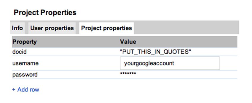
Once the spreadsheet is in place, a Google Fusion Table File > Project Properties… The developer has to enter
is created in Google Drive by choosing Create > Fusion his or her username, and add rows to enter the account
Table, importing the newly-created spreadsheet that is password and a “docid,” which will be the variable used to
already synchronized with the form. Because the latitude identify the Fusion Table ID to which the spreadsheet will
and longitude fields have to be submitted through the sync (Figure 1). It is very important to enter the “docid”
form as text, they come into the Fusion Table as text as field in quotation marks.
well, and this property has to be changed for mapping data.
Changes are made to columns in Fusion Tables by choos- After project properties have been set, a custom script
ing Edit > Add column in the menu bar. Columns are se- can be developed to synchronize the spreadsheet with
lectable on the left, and, once highlighted, their properties the Fusion Table. The process can be extremely compli-
are displayed on the right. Latitude and longitude should cated, even for those who have experience writing scripts.
be changed to location types, two column location should Fortunately, Kathryn Hurley of the Google Fusion Tables
be checked, and the new column generated automatical- team has provided a very useful script specifically in-
ly can be deleted by clicking the X next to its description. tended to synchronize Google Spreadsheets and Google
Once changes are saved, and before returning to Google Fusion Tables. The script can be accessed from http://kh-
Drive, it is very important to record the unique ID for samples.googlecode.com/svn/trunk/code/appsscript.js
the Fusion table. The ID is a 40-character alphanumeric and it should be copied from its source and pasted into
string accessed by selecting File > About in the menu of the script editor window, replacing all of the placeholder
the Fusion Table, and this string is needed for accessing text that may be present. Again, Google has made some
the table using the Google Maps API. Finally, the table minor adjustments to their online documents system since
should be shared. the creation of the script. In particular, the Google Fusion
Table ID field is now a string rather than a numeric ID,
A little bit of script editing can synchronize the Fusion so it important that the value for docid is contained with-
Table with the form, but first a project has to be prepared in quotation marks in the project properties window. That
and authorized to use scripts on a user’s account. This work way, the script will properly identify the Fusion Table to
is done in the script editor, which is accessed in the re- which it is supposed to send data. With the script copied
sponse spreadsheet by selecting Tools > Script Editor. The into the editor window, the project should then be saved.
very first task is setting the project properties for the script,
accessed in the menu bar of the script editor, by selecting The last steps of syncing the form and databases involve
automating and authorizing the sync process. In the script
editor menu, the developer should choose Select Function
Figure 1: Entering project properties to authorize scripts.
> onFormSubmit. Then, the steps should be run by select-
ing the small triangle Run button from the menu. The pro-
gram prompts the developer to authorize. After authoriz-
ing the behavior, the developer should select the Triggers
(clock icon) from the menu and click to add the trigger
mechanism: Run: onFormSumit, Events: From spreadsheet,
“on form submit.” After the steps have been completed,
input generated from the form will automatically write to
the Fusion Table as well as the response spreadsheet.
C R E AT I N G T H E M A P I N P U T S YS T E M
Google Forms automatically generates a webpage form. Within this code are several items of interest. First
for form submissions. Clicking on View live form from of all, the URL listed in the form action section is the tar-
the spreadsheet and viewing the source code for the form, get spreadsheet to which the form is sending data. Each
or grabbing the embed form in a webpage link allows a de- segment of the form lists a variable name that represents
veloper to view the HTML code for the standard input a column in the database to which records are added (e.g.,
48 | Map-based Input with Google Fusion Tables – Shepard Cartographic Perspectives, Number 75, 2013 (Pre-release)map = new google.maps.Map(document.getElementById('map-canvas'),
mapOptions);
google.maps.event.addListener(map, 'click', function(event) {
addMarker(event.latLng, map);
});
google.maps.event.addListener(map, 'click', function(event) {
var lat = document.getElementById("latbox").value = event.latLng.lat()
var lng = document.getElementById("lngbox").value = event.latLng.lng()
Example 1: Setting listeners for map click events and acquiring values for the variables (v.3).
“name = entry_1739129090”). These fields precede the text code follows a simple document.getElementByID(xxx).
that indicates the title for each input box. There is also an value = format. Examples 1 and 2 document working ex-
ID field that identifies each form box relative to other el- cerpts of this procedure using Google Maps API v.3.
ements on the page. Lastly, an important item to note is
how the HTTP POST command is used to submit re- With listeners and events set to capture coordinates to
cords to the database. Whether data are being sent using variables, the next step is copying the code from a Google
this combination of Google Maps API and Google Forms, Form into the same code as the map (alternatively, it is
or whether a developer is attempting to send data to a possible to create a custom HTML form that uses the
Fusion Table directly, the POST command is the standard same POST command to write to the same location). The
format for inserting data into Google Drive documents. id fields of the form that are intended to represent lati-
tude and longitude should be reset to the event variables
The map application input system for the Fusion Tables that are used to capture latitude and longitude, respectively
database therefore is focused on capturing user-defined (Example 2).
information in the browser, most importantly latitude and
longitude, and routing that information to the form input Once the changes to the code have been made and saved,
boxes by way of creating user-defined variables that link up input to the form posts to the Fusion Table. Each submis-
with the ID names of form input variables. sion represents one new row in the Fusion Table, and all
form fields are likewise attached to the coordinates, much
Once the map has been called in an initialize function, lis- like a true desktop GIS stores data to locations. If desired,
teners have to be set, waiting for users to commit a single the rows can be edited in the Fusion Table without affect-
click event and capture the coordinates of that click. The ing the records in the spreadsheet.layer = new google.maps.FusionTablesLayer({
query: {
select: 'Number',
from: 'li_puliVU7S4PwTrdmmYkNsJWUk1B10BxlEhD8'
},
styles: [
{where: "'Code' = 1", markerOptions: { iconName: "red_blank"}},
{where: "'Code' = 2", markerOptions: { iconName: "blu_blank"}},
{where: "'Code' = 3", markerOptions: { iconName: "grn_blank"}},
]});
layer.setMap(map);
Example 3: Google Maps API Styling from Fusion Table data.
STYLING THE INPUT
Recent issues of Cartographic Perspectives have ad-
dressed Fusion Tables styling options, focused on setting
the styles in the Fusion Table interface and using “buck-
ets” to establish choropleth map color schemes (Peterson
et al. 2012). Adding styles directly to records in the Fusion
Table, however, saves the style and associates it directly
with the data. While this gives significant control to the
developer about how features are displayed, it also restricts
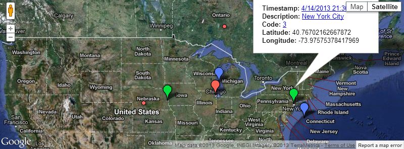
the range of potential map applications that can be built Figure 2: Markers styled according to Google Fusion Table input.
by limiting the way that the data can be used. Google
Maps API allows application creators to address the issue that polygonOptions is used instead of markerOptions,
of styles based upon their own needs. Just as the previous and, rather than calling a specific icon, the developer de-
steps have outlined the development of a crowd-sourced fines a fill color using fillColor: and fillOpacity: to
database input system, this section anticipates that multi- set an HTML color code and opacity level (from 0 to 1),
ple individuals also want to access the data in their own respectively.
ways.
In the example, the Code field is the Fusion Table column
Fusion Tables layers are styled using Google Maps API by containing descriptions that users selected for point data
expanding the layer definition section. Rather than calling when they submitted to the database (Example 3).
the table in one line of code, it is queried and styles are set
by defining the symbol for each feature. Point data markers Because the previous Google Form input steps provided a
are defined in the marker options by using iconName: to radio button with distinct and mutually exclusive catego-
reference an icon by name from Google’s list of markers ries, a user adding data through the map interface is stor-
and colors. For example, red_blank is a plain red mark- ing information about feature classes to the database. The
er symbol, while blu_blank is a plain blue marker sym- end result is a map that effectively recognizes user-defined
bol. The process of styling polygon data is similar, except classes (Figure 2).
50 | Map-based Input with Google Fusion Tables – Shepard Cartographic Perspectives, Number 75, 2013 (Pre-release)SUM M ARY
Exploiting Google’s services for their robust data automatically based on any set of parameters, potentially
management properties does constrain the developer to minimizing time demands associated with regularly updat-
Google’s limitations, such as the exclusive use of a web ing and managing data appearances on a map. The meth-
Mercator projection in all mapping, or the fact that icons ods outlined here are intended to serve as guidance for all
come from a pre-selected marker list. On the other hand, parties, although more advanced developers may seek more
a crowd-sourced geospatial data entry project can be es- control over the database and styles. Ultimately, small or-
tablished quickly and deployed in the cloud using only ganizations and individual hobbyists working with crowd-
the free tools made available by Google. The combination sourced data input are those most likely to benefit from
of Google Fusion Tables, Google Forms, and the Google the process described here.
Maps API provides a map input tool that circumvents is-
sues associated with setting up and giving user access to a Working code from the input example is available from:
MySQL database that stores data. Between Google Fusion http://robshepard.hostzi.com/samplecode.htm, and the
Tables and Google Maps API, styling options allow a finished map showing the styled Fusion Table data is avail-
developer to query user inputs and customize symbols able at http://robshepard.hostzi.com/samplecode2.htm.
REFERENCES
Peterson, Michael, Kelly Koepsell, Gabriel Pereda, and
Spencer Trowbridge. 2012. “Cloud Mapping: Google
Fusion Tables.” Cartographic Perspectives 71:77–90.
http://www.cartographicperspectives.org/index.php/
journal/article/view/cp71-peterson-et-al/html.
Cartographic Perspectives, Number 75, 2013 (Pre-release) Map-based Input with Google Fusion Tables – Shepard | 5152 | Map-based Input with Google Fusion Tables – Shepard Cartographic Perspectives, Number 75, 2013 (Pre-release)
You can also read