Maryborough District Disaster Management Plan (2021) - Version 1.0
←
→
Page content transcription
If your browser does not render page correctly, please read the page content below
Maryborough
          District Disaster
          Management Plan
                                 Version 1.0

                               (2021)

Maryborough District Disaster Management Plan   Version 1.0 July 2021
                                            1
BUSINESS
Endorsement and Authorisation
The Maryborough District Disaster Management Plan is endorsed under the
authority of the District Disaster Management Group.
This plan has been developed in accordance with the Disaster Management Act
2003 (DM Act) and the following documents to provide for effective disaster
management in the Maryborough Disaster District:
• the State Disaster Management Plan
• Queensland Emergency Management Assurance Framework
• Guidelines for District Disaster Management Groups
• Strategic Policy Framework
The plan will be maintained by the District Disaster Coordinator and will be reviewed
annually unless otherwise required.
……………………………………………
Michael Sawrey
District Disaster Coordinator
Maryborough District Disaster Management Group
Dated: 23 July 2021
Maryborough District Disaster Management Plan Version 1.0 July 2021
2Document Control
Amendment
This District plan is a controlled document. The controller of the document is the
District Disaster Coordinator (DDC). Any proposed amendments to this plan should
be forwarded in writing to:
Acting Senior Sergeant Cameron Schneider
Executive Officer
Maryborough District Disaster Management Group
PO Box 220
Maryborough QLD 4650
Any changes to the intent of the document must be endorsed by the Maryborough
District Disaster Management Group (DDMG).
A copy of each amendment is to be forwarded to those identified in the distribution
list. On receipt, the amendment is to be inserted into the document and the
Amendment Register updated and signed.
Amendment Register
No / Ref Issue Date Comment Inserted by Date
1 21/07/2021 DDMP Review A/SSgt 21/07/2021
Schneider
MoG Changes Updated
Governance Section -
Remove Functional
Lead Agency,
Supporting Lead
Agency and Hazard
Specific Plans
(duplicated in DDMP)
Community Context –
Update information to
reflect latest Census
Data
DACC Process inserted
Transition from
response operations to
recovery operations
inserted
Response Strategy
Update Recovery Lead
Agencies
Updated DDMG
member / advisor
membership
Maryborough District Disaster Management Plan Version 1.0 July 2021
3Updated Hazard
Specific Arrangements
Updated Disaster
Operations Functional
Plan Register
Distribution
This plan has been distributed in accordance with the distribution list at Annexure
A.
In compliance with section 56 of the DM Act, A copy of the plan is available on
the Queensland Police Service website: www.police.qld.gov.au
This plan is also available for inspection free of charge to members of the public.
All applications are to be made to the Executive Officer via address above or
email to DDC.Maryborough@police.qld.gov.au.
Maryborough District Disaster Management Plan Version 1.0 July 2021
4CONTENTS
BUSINESS................................................................................................. 2
Endorsement and Authorisation ....................................................... 2
Document Control............................................................................. 3
Amendment ........................................................................................ 3
Amendment Register ........................................................................... 3
Distribution......................................................................................... 4
CONTENTS ................................................................................................ 5
GOVERNANCE ........................................................................................... 9
Purpose.............................................................................................. 9
Objectives .......................................................................................... 9
Strategic Policy Framework ................................................................... 9
Scope .............................................................................................. 10
Disaster Management Priorities ........................................................... 10
Maryborough District Disaster Management Group ........................ 10
Establishment ................................................................................... 10
Role................................................................................................. 10
Functions ......................................................................................... 11
Membership ...................................................................................... 12
Roles and Responsibilities ................................................................... 13
Business and Meetings ....................................................................... 13
Capacity Building ............................................................................ 13
Post Disaster Assessment ................................................................... 13
Training ........................................................................................... 14
Exercises .......................................................................................... 14
Disaster Risk Assessment ............................................................... 15
Community Context ........................................................................... 15
Geography: ...................................................................................... 15
Land .............................................................................................. 16
Rivers and Creeks ........................................................................... 16
Burrum Coast ................................................................................. 17
Fraser Island .................................................................................. 17
Great Sandy Strait .......................................................................... 17
The Natural Environment .................................................................... 17
The Built Environment........................................................................ 17
The Community................................................................................. 18
Climate and Weather ......................................................................... 18
Demography ..................................................................................... 18
Administrative Centres ....................................................................... 19
Community Organisations................................................................... 19
Healthcare ........................................................................................ 20
Aged Care ........................................................................................ 21
Transport ......................................................................................... 21
Shopping Facilities ............................................................................. 21
Coast Guard ..................................................................................... 21
Queensland Ambulance Service ........................................................... 21
Queensland Fire and Emergency Services ............................................. 21
Queensland Police Service .................................................................. 21
State Emergency Service.................................................................... 21
Surf Life Saving................................................................................. 22
Economy / Industry ........................................................................... 22
Maryborough District Disaster Management Plan Version 1.0 July 2021
5Community Preparedness ................................................................... 22
Public Buildings ................................................................................. 22
Evacuation Centres:........................................................................... 22
Hervey Bay: ................................................................................... 22
Maryborough: ................................................................................. 23
Respite/Information Centres: .............................................................. 23
Hervey Bay: ................................................................................... 23
Maryborough: ................................................................................. 23
Special Events and Festivals ............................................................... 23
Critical Infrastructure ......................................................................... 23
Essential Services .............................................................................. 24
Hazardous Sites ................................................................................ 24
Proposed Future Development ............................................................ 25
Hazards ........................................................................................... 25
Risk Management Process .................................................................. 26
Risk Assessment ............................................................................... 26
Risk Treatment ................................................................................. 26
OPERATIONS .......................................................................................... 27
Response Strategy ......................................................................... 27
Warning Notification and Dissemination ................................................ 27
Emergency Alert................................................................................ 28
Activation and Triggers for Response ................................................... 28
District Disaster Coordination Centre ................................................... 29
Satellite Location – Liaison Officer ....................................................... 30
Staffing of the District Disaster Coordination Centre ...................... 30
Operational Reporting ........................................................................ 31
Disaster Declaration........................................................................... 31
Response Function Lead Agencies ........................................................ 32
District Level Functional Plans ............................................................. 32
Disaster Operations Functional Plan Register ......................................... 32
Hazard Specific Arrangements............................................................. 34
Threat Specific Plans .......................................................................... 35
Request for Assistance ....................................................................... 36
Request for Air Support ...................................................................... 36
Request for ADF ................................................................................ 36
Request for Supplies and Equipment .................................................... 37
Resupply .......................................................................................... 37
Recovery Strategy .......................................................................... 39
Transition Triggers............................................................................. 39
Transition from response operations to recovery operations .................... 39
Immediate/Short Term Recovery ......................................................... 39
Medium/Long Term Recovery .............................................................. 39
Maryborough District Human and Social Recovery Committee ................. 40
Parameters ....................................................................................... 40
Operational and Action Plans............................................................... 41
Considerations for Recovery................................................................ 41
Recovery Lead Agencies ..................................................................... 41
OPERATIONAL PLANS ............................................................................. 42
REVIEW AND ASSURANCE ...................................................................... 44
Review and Renew Plan...................................................................... 44
External Assessment .......................................................................... 44
Review of Local Disaster Management Arrangements ............................. 45
ANNEXURE INDEX .................................................................................. 46
Maryborough District Disaster Management Plan Version 1.0 July 2021
6Annexure A - Distribution List ........................................................ 47
Annexure B - Maryborough District Disaster Management Group
Contact List .................................................................................... 49
Annexure C - Maryborough District Risk Register ........................... 50
Annexure D - Maryborough District Risk Analysis ........................... 59
Annexure E - Maryborough District Risk Evaluation........................ 67
Annexure F - Maryborough District Risk Treatment Plan ................ 73
Annexure G – Abbreviations and Acronyms .................................... 82
Annexure H - Definitions ................................................................ 84
Annexure I – 2020/2021 Annual Operational Plan ......................... 89
Disaster Management Priorities: .................................................... 89
Principles of Disaster Management: ............................................... 90
Maryborough District Disaster Management Plan Version 1.0 July 2021
7Annexure Index
A Distribution List
B Maryborough District Disaster Management Group Contact List
C Maryborough District Risk Register
D Maryborough District Risk Analysis
E Maryborough District Risk Evaluation
F Maryborough District Risk Treatment Plan
G Abbreviations and Acronyms
H Definitions
I Maryborough DDMG Annual Operational Plan
Maryborough District Disaster Management Plan Version 1.0 July 2021
8GOVERNANCE
Purpose
This district disaster management plan is prepared under the provision of Section
53 of the Disaster Management Act 2003. This plan details the arrangements within
the Maryborough Disaster District to provide whole-of-government planning and
coordination capability to support local governments in disaster management.
Objectives
The objective of the Maryborough District Disaster Management Plan is to facilitate
the implementation of effective and efficient disaster management strategies and
arrangements including:
• the development, review and assessment of effective disaster
management for the district including arrangements for mitigating,
preventing, preparing for, responding to and recovering from a disaster;
• compliance with the Queensland Disaster Management Committee’s
(QDMC) Strategic Policy Framework; the State Disaster Management Plan;
the District Disaster Management Guidelines; and any other Guidelines
relevant to district level disaster management.
• the development, implementation and monitoring priorities for disaster
management for the district.
Strategic Policy Framework
Disaster management and disaster operations in the Maryborough Disaster District
are consistent with the Disaster Management Strategic Policy Framework. This is
achieved by:
• Ensuring a comprehensive, all hazards, all agencies approach by achieving
the right balance of prevention, preparedness, response and recovery;
• Supporting the mainstreaming of disaster preparedness and mitigation
into relevant areas of activity of government, non-government, small
business and corporations;
• Aligning disaster risk reduction, disaster mitigation, disaster resilience and
climate change adaptation policy and actions with international and
national reforms;
• Promoting a transparent, systematic and consistent approach to disaster
risk assessment and management, based on the Queensland Emergency
Risk Management Framework (QERMF);
• Recognising the commitment of stakeholders and the need for
collaboration across all levels of government, community, industry,
commerce, government owned corporations, private and volunteer
organisations, and local communities in all aspects of disaster
management;
• Emphasising building and maintaining sincere relationships, trust,
teamwork, consultative decision-making and shared responsibilities among
stakeholders; and
• Promoting community resilience and economic sustainability through
disaster risk reduction.
Maryborough District Disaster Management Plan Version 1.0 July 2021
9Scope
This plan details the arrangements necessary to undertake disaster management
within the Maryborough Disaster District in support of the Fraser Coast Regional
Council. This entails the use of any State and Commonwealth government
department and/or agencies and all resources available for the prevention of,
preparedness for, response to and recovery from, the effects of disasters or events
having a community consequence, whilst utilising an all hazards approach.
Disaster Management Priorities
The priorities for the Maryborough Disaster Management Group are to:
• Improve community (including business) disaster planning, mitigation and
preparation;
• Manage training of DDMG members in line with the Queensland Disaster
Management Training Framework.
• Integrate effective disaster risk reduction initiatives into strategic and
corporate plans at appropriate levels of government, community
organisations, industry and commerce.
• Monitor and evaluate the disaster management arrangements to:
- streamline arrangements;
- develop clear accountability, including defined roles and
responsibilities at all levels of the disaster management
arrangements;
- improve the communication flow process; and
- develop whole-of-government, media and community engagement
arrangements.
The Annual Operational Priorities for the Maryborough DDMG are contained within
the DDMG Annual Operational Plan attached at Annexure I.
This operational plan outlines the operational priorities for the forthcoming year
pursuant to the provisions of Section 53 (2) (e) of the Disaster Management Act
2003.
The operational plan is used as a tool to outline, implement, manage and monitor
current disaster management priorities for the district and will be reviewed
annually by the XO in consultation with the Chair of the DDMG and member
agencies.
Maryborough District Disaster Management
Group
Establishment
The Maryborough District Disaster Management Group (DDMG) is established in
accordance with section 22; ‘Functions’ of the Act which incorporates the Fraser
Coast Council area.
Role
Maryborough District Disaster Management Plan Version 1.0 July 2021
10The Maryborough District Disaster Management Group is comprised of
representatives from regionally based Queensland government agencies,
government owned corporations, non-government organisation, industry and
commerce and key community representatives, who can provide and coordinate
whole-of-Government support and resource gap assistance to disaster affected
communities.
The Maryborough DDMG performs a ‘middle management’ function within
Queensland Disaster Management Arrangements (QDMA) by providing
coordinated state government support when requested by the Local Disaster
Management Group (LDMG).
Functions
Functions (s23 of the DM Act) Under the DM Act, the Maryborough District
Disaster Management Group has the following functions for which it is
established;
(a) to ensure that disaster management and disaster operations in the district are
consistent with the State group’s strategic policy framework for disaster
management for the State;
(b) to develop effective disaster management for the district, including a district
disaster management plan, and regularly review and assess that disaster
management;
(c) to provide reports and make recommendations to the State group about
matters relating to disaster management and disaster operations in the district;
(d) to regularly review and assess the disaster management of local groups in the
district;
(e) to ensure that any relevant decisions and policies made by the State group
are incorporated in its disaster management, and the disaster management of
local groups in the district;
(f) to ensure the community is aware of ways of mitigating the adverse effects of
an event, and preparing for, responding to and recovering from a disaster;
(g) to coordinate the provision of State resources and services provided to
support local groups in the district;
(h) to identify resources that may be used for disaster operations in the district;
(i) to make plans for the allocation, and coordination of the use, of resources
mentioned in paragraph (h);
(j) to establish and review communications systems in the group, and with and
between local groups in the district, for use when a disaster happens;
(k) to ensure information about an event or a disaster in the district is promptly
given to the State group and each local group in the district;
(l) to prepare, under section 53, a district disaster management plan;
(m) to perform other functions given to the group under this Act;
Maryborough District Disaster Management Plan Version 1.0 July 2021
11(n) to perform a function incidental to a function mentioned in paragraphs (a) to
(m).
Membership
The DDMG is comprised of persons and representatives as nominated in section
24 of the Act ‘Membership’;
• Chairperson – District Disaster Coordinator
• Deputy Chairperson
• Executive Officer
• A representative of each local government agency within the district and;
• Persons representing departments whom the QDMC in consultation with
the DDC considers appropriate to be represented on the group.
The core membership of the Maryborough District Disaster Management Group
is comprised of the following;
• Queensland Police Service (QPS)
- Chairperson
- Deputy Chairperson
- Executive Officer
• Local Government within Disaster District – Fraser Coast Regional Council
• Queensland Fire and Emergency Services (QFES)
- Emergency Management
- Operational
- State Emergency Service (SES)
• Queensland Ambulance Service (QAS)
• Department of Communities, Housing and Digital Economy (DCHDE)
- Communities
- Housing and Homelessness
• Department of Health (Q-Health)
• Department of Transport & Main Roads (DTMR)
- Main Roads
- Maritime Safety Qld (MSQ)
• Department of State Development, Infrastructure, Local Government and
Planning (DSDILGP)
• Department of Education (DoE)
• Department of Energy and Public Works (DEPW)
- Q-Build
• Department of Environment and Science (DES)
• Department of Agriculture and Fisheries (DAF)
• Energex
• Telstra
Representatives of the following departments / agencies may be invited to attend
DDMG meetings and assist in disaster operations in an advisory and co-
operative disaster capacity as required:
Maryborough District Disaster Management Plan Version 1.0 July 2021
12• Australian Broadcasting Commission (ABC)
• Australian Defence Forces – MJOSS/SQ
• Department of Children, Youth Justice and Multicultural Affairs (DCYJMA)
• Department of Regional Development, Manufacturing and Water (DRDMW)
- Water
• Department of Premier and Cabinet (DPC)
• Australian Red Cross
• Bureau of Meteorology (BoM)
• Queensland Building and Construction Commission (QBCC)
• Queensland Reconstruction Authority (QRA)
• Queensland Rail (QR)
The Maryborough DDMG Contact list is updated at DDMG meetings and is included
as Annexure B to this plan.
Roles and Responsibilities
A detailed itemisation of the roles and responsibilities of member agencies are
outlined within the State Disaster Management Plan. The Maryborough District
Disaster Management Group adopts the itemisation of these roles and
responsibilities at the district level.
State Disaster Management Plan (SDMP)
Business and Meetings
Reporting requirements within the Maryborough Disaster District shall be in
accordance with s. 38 of the DM Act, and Queensland’s District Disaster
Management Group Guidelines. The DDMG may conduct its business, including
its meetings, in a way it considers appropriate.
Reporting requirements within the Maryborough Disaster District shall be
consistent with the requirements of Queensland’s District Disaster Management
Group Guidelines as follows:
DDMG guidelines
Disaster Management Act 2003
Capacity Building
Post Disaster Assessment
The review of operational activities undertaken during a disaster is a key
component in ensuring capability development and the continuous improvement
of disaster management arrangements.
Post-disaster reviews are conducted to:
• assess disaster operations undertaken for a given disaster including
actions, decisions or processes;
Maryborough District Disaster Management Plan Version 1.0 July 2021
13• document those processes that worked well and identify a course of action
to ensure that they are captured and updated in relevant doctrine for use
in the next operation and;
• assess capability and consider where additional training and/or exercises
may enhance capacity.
Guidelines and reporting requirements relating to post disaster assessments are
contained within the Queensland Prevention, Preparedness, Response and
Recovery Disaster Management Guideline:
Queensland Prevention, Preparedness, Response and Recovery Disaster
Management Guideline
Training
Disaster management training has been identified as an essential means through
which agencies can develop and maintain their disaster management capabilities
and capacity. Training and education can provide the knowledge, skills and
attitudes required to address the issues of disaster management through
prevention, preparedness, response and recovery. Furthermore, training is
important in ensuring that all agencies can seamlessly integrate their
arrangements and contribute to an effective and coordinated disaster
management response.
The Maryborough QFES District Emergency Management Coordinator (EMC) is
responsible for delivering disaster management training within the district with
the help of coordination by the Local Government Disaster Management Officers
and maintaining a calendar for training conducted within the district. This process
enables the Maryborough District to collaborate on dates for training, exercising
and meetings.
Agencies and organisations represented on the DDMG have the responsibility of
providing suitable opportunities for DDMG representatives (including deputies) to
attend required training. In addition, each agency also has a responsibility to
conduct relevant internal training/exercising of their staff and where appropriate,
offer other agencies the opportunity to participate.
To enhance knowledge and disaster management capabilities DDMG
representatives (including deputies) are encouraged to complete training courses
beyond their relevant minimum requirements of the Queensland Disaster
Management Training Framework.
Exercises
Exercises are a key component of disaster management strategies and are
conducted with the objective of:
• practicing the coordination procedures during an event including;
• activation of Disaster Management Groups;
• activation of District Disaster Coordination Centres;
• information management including dissemination of information in respect
to threats and warnings, requests for assistance and providing situation
reports
• enhancing the interoperability of agency representatives;
• evaluating emergency plans;
Maryborough District Disaster Management Plan Version 1.0 July 2021
14• identifying planning and resource issues;
• promoting awareness;
• developing competence;
• evaluating risk treatment strategies;
• validating training already conducted;
• identifying performance gaps and areas for the potential improvement in
the skills of agency representatives involved in disaster management; and
• evaluation of equipment, techniques and processes in general.
The DDMG will conduct at least one exercise annually, to include all core
members of the DDMG. Additionally, on an annual basis, functional committees
will exercise their respective sub-plans, independent of the disaster district
exercise.
Disaster Risk Assessment
Community Context
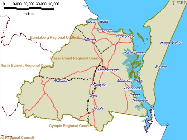
Figure 2: Map of the Maryborough Disaster District and localities
The Maryborough Disaster District comprises the local government areas of the
Fraser Coast Regional Council.
Geography:
The Maryborough Disaster District is in South East Queensland approximately 250
kilometres north of Brisbane. It covers a total area of 7,125 km which includes
waterways from Burrum Heads to Inskip Point south of Fraser Island.
The Fraser Coast Region covers an area of 7,125 km from the Gunalda Range to
the south, past Howard on the Bruce Highway to the north, east to the World
Heritage listed Fraser Island and west to Brooweena. The Fraser Coast region has
Maryborough District Disaster Management Plan Version 1.0 July 2021
15a complex and diverse geography that includes Fraser Island, the Mary River,
large areas of native bushland, commercial forestry plantations and significant
residential areas in low lying coastal zones.
Land
The Fraser Coast is a region of rich diversity. Within its extensive boundaries, is
the sand mass of Fraser Island, the wetlands of the Great Sandy Strait, marine
waters, coastal lowlands and streams, three significant river systems (Mary,
Susan and Burrum) and undulating hills bordered by the Sea View Range
(201metres above sea level) and Clifton Range (289metres above sea level) in
the Wongi Forest Reserve. The natural environment of the Fraser Coast provides
substantial income to the region and is the major drawcard for tourists.
This region offers many opportunities for maintaining and preserving biodiversity.
The area has large tracts of remnant vegetation associated with mountain ranges
and land in public ownership and coastal areas have been subject to the same
levels of population growth and urban expansion that has been occurring in the
southern part of the bioregion.
The Queensland Department of Environment and Science is responsible for the
management of Forests and National Parks in the area. The topography of the
area consists of coastal heath and wallum lands adjacent to the Great Sandy Strait
giving way to undulating grazing and timbered country through the centre of the
region to hilly country in the Urah Range (524metres above sea level) to the south
west of Tiaro.
Rivers and Creeks
The Burrum and Mary Rivers flow to the coast in the Fraser Coast region where
there are many tidal areas in low-lying coastal communities. The regions
shoreline encompasses 112km from Burrum Heads in the north, to Tinnanbar in
the south, and includes those parts of the shoreline immediately landward that
are within 100m of the mean high-water mark. This excludes the Fraser Island
shoreline.
The estuary of all the Fraser Coast Rivers includes seagrass beds, diverse
mangrove forests, Fish Habitat Areas and habitat for sea turtles and dugongs. The
Mary River estuary is shared with the Susan River. The Mary River estuary is at a
"high" risk of damage by human activities and the estuary’s health is currently
rated as "fair" (C+), whilst the Susan River estuary is at a "low" level of risk of
damage by human activities and the estuary’s health rating is "excellent" (A).
Susan River features include no in stream barriers to fish passage, significant
wetlands and mangrove community.
Major creeks within the Mary River include Tinana, Myrtle, Gutchy and Munna.
Significant patches of remnant rainforest and endangered regional ecosystems
are located on Tinana Creek. Fish passage is disrupted on the main trunk of the
river by the Mary River tidal barrage, on Tinana Creek by Teddington Weir,
Tallegalla Weir and Tinana Barrage. Other smaller barriers to fish passage exist
throughout the catchment.
The Cherwell and Isis Rivers share the same estuary as the Burrum River. The
Burrum River estuary is at a "low" level of risk of damage by human activities and
the estuary’s health is currently rated as "good" (B+), although fish passage is
severely disrupted on the Burrum River by Lenthalls Dam and the two weirs.
Adjacent to Lenthalls Dam is a significant patch of remnant rainforest. Wongi
Maryborough District Disaster Management Plan Version 1.0 July 2021
16waterholes comprise a string of permanent acid-swamp waterholes, which provide
habitat for threatened acid frogs.
Significant wetlands within the region are:
Burrum Coast
comprises the coastline and estuaries between, and including, Beelbi and
Theodolite Creeks, and is made up of extensive intertidal flats associated with the
mouth of the Burrum River and adjacent coastline; mangrove and salt flat systems
along estuaries and coastline; freshwater wetlands dominated by wallum heaths,
and lesser areas of sedge land and swamp forests;
Fraser Island
the largest sand island in the world with huge reserves of fresh groundwater and
characteristic window and barrage dune lakes and a topography characterised by
rough dunes reaching an elevation of more than 220m; and
Great Sandy Strait
a very large and complex wetland system, consisting of intertidal sand and mud
flats, extensive seagrass beds, mangrove forests, salt flats and salt marshes.
The Natural Environment
The Fraser Coast is considered to have a mild sub-tropical climate with most rain
occurring from December to May. The average annual rainfall is 1100mm. It has
warm to hot and humid summers to dry to moderate winters. The district’s
temperatures range from an average of 22-28 degrees in summer and 14 -21
degrees in winter. The district can be subject to extremes of both temperature
and rainfall.
Thunderstorms are common within the district from December to February each
year with the threat of wildfire between September and February each year.
Coastal areas may be prone to storm surges and tsunamis. The Fraser Coast lies
in a tropical cyclone risk area with East Coast Lows however cyclones crossing the
coastline or significantly affecting the Fraser Coast are rare.
The Fraser Coast region sits within the North-East Coast rivers system basin.
There are two (2) main river systems being the Mary and Burrum Rivers. There
are two (2) main water areas (dam/lake) within the region being at Lenthalls
Dam and Poona; there are also major water reserves and wetlands through the
region.
The Region is drained by the Mary and Burrum Rivers and their tributaries, which
flow to the north and exit into the Great Sandy Straits.
The Built Environment
The major centres in the region are Maryborough and Hervey Bay with smaller
centres spread out though the region. These centres accommodate key education,
business, service and retail uses.
The Fraser Coast Region receives over 785,000 domestic visitors annually and
approximately 191,000 international visitors annually. The region is well connected
and easily accessible through the Maryborough and Hervey Bay Airports. The
region is served by the primary land transport corridor, the Bruce Highway and the
North Coast railway line.
Maryborough District Disaster Management Plan Version 1.0 July 2021
17The Community
The estimated residential population of the Fraser Coast is approximately 101,504,
projections prepared by the Department of Infrastructure and Planning indicate
that by 2031 the total residential population of the Fraser Coast is expected to grow
to approximately 164,143 people.
The bulk of the urban population in the Fraser Coast region lives either at
Maryborough or Hervey Bay. Towns and urban centres are also located on the
coastal fringe to Burrum Heads and inland to Teebar.
The Fraser Coast Council has conducted an informal community resilience,
preparedness and awareness study. They have conducted print, electronic and
radio campaigns to increase the community’s disaster awareness and
preparedness. The community’s preparedness is generally good and expected to
improve with the further work conducted in conjunction with the Fraser Coast
Council and the Local Disaster Management Group.
The Department of Communities Disability Services provides disability services,
support and facilities to people with a disability and their careers living in the Fraser
Coast region. Community Integrated Sub Acute Services (CISAS) are delivered in
a variety of settings including hospitals, community-based centres, residential aged
care, satellite and outreach services, mobile services and in people’s homes.
Climate and Weather
The Fraser Coast is considered to have a mild sub-tropical climate with most rain
occurring from December to May. The average annual rainfall is 1100mm. It has
warm to hot and humid summers to dry to moderate winters. The district’s
temperatures range from an average of 22-28 degrees in summer and 14-21
degrees in winter. The district can be subject to extremes of both temperature
and rainfall.
Thunderstorms are common within the district from December to February each
year with the threat of wildfire between September and February each year.
Coastal areas may be prone to storm surges and tsunamis. The Fraser Coast lies
in a tropical cyclone risk area with East Coast Lows however cyclones crossing the
coastline or significantly affecting the Fraser Coast are rare.
Demography
The 2020 Australian Bureau of Statistics Census population of Fraser Coast region
was 108,183 people of these 49% were male and 51% were female. Aboriginal
and/or Torres Strait Islander people made up 4.2% of the population. The
median age of residents is 49 years. Fraser Coast region has 38,991 dwellings
(ABS 2016 Ref.) with 30,192 dwellings having internet connection
The population in the Fraser Coast region is spread along the coast at Hervey Bay
and surrounds, Maryborough and inland country areas to Teebar the region also
hosts the main railway corridor for north/south bound trains.
High tourist and visitor numbers, especially during peak tourist seasons,
considerably increase the overall population on any given day. The Fraser Coast
Region receives over 785,000 domestic visitors annually and approximately
191,000 international visitors annually.
Projections prepared by the Department of Local Government, Racing and
Multicultural affairs indicate that by 2031 the total residential population of the
Fraser Coast is expected to grow to approximately 164,143 people. In 2016,
Maryborough District Disaster Management Plan Version 1.0 July 2021
1832,266 people living in Fraser Coast Council area were employed in a combination
of both full and part-time employment.
The age structure of the Fraser Coast is significantly older than the Queensland
average with a median age of 49 years as opposed to a Queensland average of
37 years. This reflects the high number of retirees and baby boomers who have
moved to the region, and the number of young adults (15-24 years) migrating
away for employment and educational opportunities.
Analysis of household income levels in Fraser Coast region in 2016 shows that the
median personal income per week for individuals was $468 and family being
$1,090 which is lower that the State average of $660 (individual) and family
income being $1,661. This is reflected in the number of aged retirees and
unemployed persons residing throughout the region.
People living in the Fraser Coast were predominantly born in Australia (77.7%),
which is higher than the Queensland average (71.1%). Of the remaining
population people not born in Australia were 12% from “English Speaking
Countries” and 5% from “Non-English-Speaking Countries”.
Administrative Centres
The major centres in the region are Maryborough and Hervey Bay with many
small rural towns with rural subdivisions at Aldershot, Antigua, Aramara, Bauple,
Boonooroo, Brooweena, Burrum Heads, Dundathu, Glenwood, Gundiah, Howard,
Fraser Island, Maaroom, Miva, Oakhurst, River Heads, Teebar, Tiaro, Tinnanbar,
Toogoom, Torbanlea, Poona, Little Tinana, Bidwell and Yengarie. These centres
accommodate key education, business, service and retail uses.
Fraser Coast Council, Queensland Government and Australian Government
maintain offices and depots located at Maryborough and Hervey Bay and across
the region for delivery of services to the community.
Community Organisations
There are numerous community sporting, cultural and service groups across the
region registered on the Fraser Coast Community Information Services (CIS)
database. Website address: www.frasercoastcis.qld.gov.au.
Maryborough District Disaster Management Plan Version 1.0 July 2021
19Healthcare
The Fraser Coast supports the Wide Bay Hospital and Health Service (WBHHS) for
the region. There are three (3) hospitals within the region being the Maryborough
Base and Hervey Bay (Public) Hospitals, St Stephen’s Private Hospital. There are
numerous General Practices, associated/allied health care professionals and
Pharmacies throughout the region to meet community needs for health care.
The Department of Communities, Disability Services and Seniors provides
disability services, support and facilities to people with a disability and their
careers living in the Fraser Coast Region.
Community Integrated Sub Acute Services (CISAS) are delivered in a variety of
settings including hospitals, community-based centres, residential aged care,
satellite and outreach services, mobile services and in people’s homes.
These services include:
• Oral Health
• Breast Screen Queensland
• Residential Aged Care Facilities
• Palliative Care Unit
• Palliative Care Outreach
• Aboriginal and Torres Strait Islander Health
• Transition Care Program
Maryborough District Disaster Management Plan Version 1.0 July 2021
20• Community Sub Acute Program (CSAP)
• Community Rehabilitation
• Aged Care Assessment (ACAT)
• Adult Health Program
• Community Hospital Interface Program (CHIP)
• Alcohol Tobacco and Other Drug Services (ATODS)
• Fraser Coast Public Health Unit
Aged Care
With a growing aged population, the region has experienced the development of
state-of-the-art aged care services along with extensive medical and supporting
infrastructure and services.
As of 31 May 2020, there are 36 aged care facilities in the Fraser Coast providing
serves to 1,351 community residents. Services include community care (370
persons) and residential care (981 persons).
Transport
The region is well connected and easily accessible through both the Maryborough
and Hervey Bay Airports which are serviced by regional airlines i.e. Qantas Link
and Virgin Australia. The region is serviced by the major land corridor being the
Bruce Highway and is also connected to major centres by both rail and bus
services operating on a regular timetable.
Shopping Facilities
The region has shopping precincts in each town supported by major centres at
Maryborough and Hervey Bay.
Coast Guard
There is an active Australian Volunteer Coastguard Squadrons located on the
Fraser Coast with flotillas located at Boonooroo (2 vessels) and Hervey Bay (2
vessels). These units service all areas from Sandy Cape to Double Island Point.
Queensland Ambulance Service
Ambulance Stations are located across the region at: Maryborough, Hervey Bay,
Howard and Fraser Island. A First Responder Group (FRG) is also attached to
Hervey Bay Volunteer Marine Rescue (VMR).
Queensland Fire and Emergency Services
Fraser Coast region is serviced by 75 Urban and Rural Brigades which are
supported by both the Fraser Coast Regional Council and QFES Rural Operations.
Queensland Police Service
Police Stations are located across the region at: Maryborough, Hervey Bay, Tiaro,
Howard and Fraser Island.
State Emergency Service
SES Units are active on the Fraser Coast, with groups located at Maryborough,
Hervey Bay, Boonooroo, Tiaro, Burrum Heads and Howard.
Maryborough District Disaster Management Plan Version 1.0 July 2021
21Surf Life Saving
The Fraser Coast region has a surf club located at Hervey Bay which provided
regular patrols for the nominated waterways within the region but predominantly
at Hervey Bay beaches
Economy / Industry
The Fraser Coast region’s gross regional product (GRP) has been growing
steadily, although growth has slowed recently due to the GFC. The size of the
region’s economy is estimated (June 2020) at $4.4 billon.
Key drivers of this economic growth have been:
• Increase in population;
• Growth in the key coastal industries such as tourism, retail and
construction; and
• Attracting a more flexible workforce.
This economic activity for the region is supported by industry in the following
areas: Manufacturing employing 2,300 persons; Retail employing 4,447 persons;
Construction employing 2,434 persons; Education & Training employing 3,233
persons; Agriculture/Forestry employing 1,350; Marine/Seafood employing 400
persons and Tourism employing 6,015 persons (source: Economic Development
Strategy 2015-2020).
Community Preparedness
Public education consists of an ongoing public awareness and preparedness
program conducted by the State Emergency Service, Fraser Coast Regional Council,
Statutory Services and the media in conjunction with the DDMG aimed at
encouraging the public to be prepared for emergencies. This includes the production
and delivery of the Fraser Coast Emergency Action Guide to all residences in the
district.
The Fraser Coast Regional Council has established seventeen (17) Community
Coordination Committees (CCCs) for community connectedness and resilience
within the whole community. Fraser Coast Council has also established business
owners into three (3) flood committees that meet regularly to discuss flood
preparedness and recovery. The community’s preparedness is generally good
and expected to improve with further work conducted in conjunction with the
Fraser Coast Regional Council and Local Disaster Management Group.
Public Buildings
Throughout the Fraser Coast region there are a number of public and community
buildings, with many of these able to be utilised as evacuation or temporary
respite/information centres. These include:
Evacuation Centres:
Hervey Bay:
• Hervey Bay Baptist Church.
• Hervey Bay Community Centre.
• Hervey Bay PCYC
Maryborough District Disaster Management Plan Version 1.0 July 2021
22Maryborough:
• Maryborough & District Hockey Association Hall.
• Maryborough Recreation Centre.
• Maryborough Showgrounds & Equestrian Park.
Respite/Information Centres:
Hervey Bay:
• Community Hall Burrum Heads.
• River heads Community Centre.
• Toogoom Community Hall.
• Toogoom RSL.
Maryborough:
• The Brolga Theatre.
• Granville Community Hall.
• Maryborough Town Hall.
• Woocoo/Oakhurst Community Hall.
• Aldershot Hall.
• Bauple Recreation Hall.
• Bidwill Magnolia Hall.
• Boonooroo Progress Association Hall.
• Burrum & District Recreation Centre.
• Glenwood Community Hall.
• Gundiah Community Place.
• Maaroom Community Hall.
• Poona Centenary Hall.
• Susan River Homestead (Commercial Business).
• Teebar Hall.
• Tiaro Memorial Hall.
• Torbanlea Community Hall.
• Little Tinana Recreation Grounds.
Special Events and Festivals
Special events that attract large concentrations of people include:
• Relish Festival – June.
• World’s Greatest Pub Crawl – June.
• Mary Poppins Festival – July.
• Whale festival & watching season – August / October.
• Seafood Festival – August.
• Technology Challenge Maryborough – September.
• Get Ready Concert & Emergency Services Display – October.
Critical Infrastructure
Key infrastructure in the Fraser Coast region includes:
Maryborough District Disaster Management Plan Version 1.0 July 2021
23• Strategic road corridors including the Bruce Highway and main
Maryborough to Hervey Bay Road.
• Main North Coast Rail Line.
• Maryborough and Hervey Bay Airports & Pacific Haven Airfield (non-
commercial).
• Water storage: Dams/Water treatment plants/sewerage facilities being
Lenthall Dam, Eli Creek Effluent Storage Dam, Water and Sewerage
Treatment plants.
• Stormwater and underground drainage networks.
• Electricity distribution network.
• Telecommunications networks (voice and data).
• Repeater stations for Radio and TV.
• Beaches, recreational parks and reserves.
Essential Services
Essential services on the Fraser Coast include:
• Electricity: Ergon Energy is the region’s electricity distribution network
provider. Gas Supply: LP Gas is only available in cylinders and is
distributed by authorised agents.
• Water Supply: Major water treatment plants are located at Tiaro, Howard,
Burgowan and adjacent to Teddington Weir, Maryborough. Other small
towns have local water supplies and other properties rely on tank water.
• Sewerage: Most urban properties are connected to Wide Bay Water’s
sewerage system. Those properties not connected to the system have a
range of on-site treatment systems which are managed by either Wide Bay
Water or through private companies.
• Telecommunications. The landline and mobile phone network have several
service providers. The top three are Telstra, Optus and Vodafone-
Hutchinson Australia (VHA)Internet connection: It is estimated that 70 per
cent of households in the Fraser Coast Region have an internet connection
at their dwelling. Fixed line, WiFi and 3/4G internet connections are
available through a range of service providers.
Hazardous Sites
• A range of dangerous goods travel via bulk tankers and intermediate or
smaller containers along the Brisbane to Gladstone transport corridor.
These include petroleum, liquefied petroleum gas, liquefied ammonia,
molten sulphur, liquefied chlorine, concentrated hydrochloric acid,
compressed hydrogen, and sodium cyanide. The primary road route
comprises Brisbane’s Gateway Motorway, the Bruce Highway (National
Route 1) and feeder roads to/from regional centres.The rail link (North
Coast railway) closely parallels the highway, as with the Bruce Highway
dangerous goods and hazardous goods travel up this rail corridor with the
two routes rarely being separated by more than a few kilometres.Both
routes pass either through or near numerous settled areas, including the
Fraser Coast Hinterland, regional centres and smaller towns.
• There are a significant number of fuel storage depots including service
stations and marina refuelling facilities throughout the region.There are
major hardware and cooperative warehouses across the region.
Maryborough District Disaster Management Plan Version 1.0 July 2021
24Proposed Future Development
The Fraser Coast is a growing community. Proposed urban or infrastructure
developments within the Fraser Coast Region include; development of the Mary
River Harbour, Marine Industrial Precinct and Medical Precinct.
Hazards
In 2016, a regional Disaster Risk Assessment covering 23 Natural and human-
made hazards that may impact on the region was compiled. This risk
assessment took in to account seasonal variations each of the risks to ensure a
more dynamic and accurate assessment of the risk exposures for the region.
The hazards identified as affecting the Fraser Coast Disaster District are:
• East Coast Low Pressure System.
• Severe Thunderstorm / Electrical Storm.
• Tropical Cyclone (Category 1/2/3 Sandy Cape to Point Danger).
• Tropical Cyclone (Category 4/5 Sandy Cape to Point Danger).
• Storm Tide (> HAT 0.5m).
• Flood (Q20 impacting on Fraser Coast Region).
• Dam Failure.
• Tornado (Grade F1 – winds 117-180kmh).
• Major Earthquake.
• Tsunami (>10m wave and land inundation > 1km inland).
• Landslide.
• Prolonged Drought.
• Bushfire (Rural and Interface areas).
• Major Fire (Urban/Industrial Area).
• Hazardous Material Accident (Land Transport Corridor).
• Hazardous Material Accident (Marine Environment).
• Major Passenger Transport Accident (Road/Rail Casualties).
• Major Air Transport Accident.
• Pandemic.
• Extreme High Temperatures (>36degrees, >2 days).
• Exotic Animal/Plant Disease
• Terrorism.
• Cyber Security Incident (Emerging Risk).
• Black Swan (Unpredictable, Extreme/Concurrent Events).
Detailed Natural Disaster Risk Assessment Studies have been undertaken by the
Fraser Coast Council. These Studies provide information on specific risks within
the Fraser Coast District and took into consideration earlier studies.
These studies include:
• Storm Tide Studies.
• Flood Risk Assessment Reports / Catchment Management Studies.
• Bushfire Risk Management Studies.
• Landslide Risk Assessment Studies.
• City and Shire Plans.
Maryborough District Disaster Management Plan Version 1.0 July 2021
25Risk Management Process
Risk management processes conducted by the group are to be undertaken in
accordance with the Queensland Emergency Risk Management Framework
(QERMF), National Emergency Risk Assessment Guidelines and comply with Risk
Management Standard AS/NZS ISO 31000:2009.
The Maryborough DDMG will form a Disaster Risk Management Subgroup which
will meet at least annually to review the Fraser Coast Disaster District Risk
Management Plan. This group will comprise of identified stakeholders and be
chaired by the XO of the DDMG. Also, sitting on the Group will be a suitable
representative of each of the local Government Areas and the QFES EMC to
provide input into the risks transferred or shared between the Local Government
areas and the District Disaster Management Group.
Risk Assessment
The DDMG has undertaken a risk assessment and developed a District risk
register incorporating risk identification, risk analysis and risk evaluation in
accordance with the process outlined in the National Risk Assessment Guidelines.
The assessment looked at the 23 identified hazards across the year and
incorporated seasonal variations to the likelihood and consequences of those
risks. The risks identified in the District risk register are not a duplication of
those risks identified in the Local Disaster Management Group’s risk register and
seeks to only address those risks that will significantly impact on the local
government area to such a degree that the risk requires transferring to, or
sharing with, the District.
Those risks and their evaluation and analysis are contained in Annexures C and D
of this plan.
The Risk Assessment provided in Annexure E is a preliminary risk assessment
based on the results of an undergoing review of the Fraser Coast Regional
Council’s Disaster Hazard Risk Assessments to identify residual risk.
Risk Treatment
Risks outlined in the District Risk Register are analysed by members of the
Maryborough DDMG with a view to identifying strategies for risk treatment.
These strategies are contained in the District Risk Treatment Plan (detailed in
Annexure F of this plan). Along with these strategies, the District Risk Treatment
Plan contains preferred treatment options, responsibilities and timeframes for
implementation.
The allocation of responsibility for the implementation of risk treatment
strategies, monitoring and reporting shall be determined by members of the
DDMG under the guidance of the DDC. The District Risk Treatment Plan is to be
presented to the Maryborough DDMG for ratification.
To progress any treatment options, the DDMG is to request relevant responsible
agencies to incorporate specified risk treatment strategies into their agency
corporate planning processes for recognition and implementation.
In instances where the applications of treatment strategies at district level are
identified as not being adequate and residual risks remain, the DDMG is to
determine whether risk transfer or risk sharing with the QDMC is a treatment
Maryborough District Disaster Management Plan Version 1.0 July 2021
26You can also read