EAST GRINSTEAD NEIGHBOURHOOD PLAN - East
←
→
Page content transcription
If your browser does not render page correctly, please read the page content below

EAST GRINSTEAD
NEIGHBOURHOOD PLAN
         East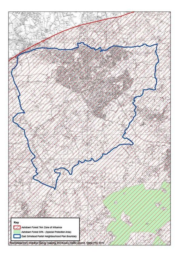
East Grinstead Neighbourhood Plan
                                   plan made November 2016
         Consultation D

East Grinstead Neighbourhood Plan

              2
East Grinstead Neighbourhood Plan
                                                                          plan made November 2016
                                      FOREWORD
East Grinstead is an attractive town located within the heart of the southeast of England. It has a
unique heritage and provides a pleasant place to live and work with ample opportunity to enjoy
both town and country alike. However, like many sought after locations, East Grinstead suffers
from major pressures for growth and is heavily constrained by its existing infrastructure
limitations. Due to a number of circumstances outside of the community’s control, the town has
suffered from unplanned and ad hoc development proposals in past years.

With these pressures in mind, the East Grinstead Neighbourhood Plan sets out a vision for the
area that reflects the thoughts and feelings of local people. Whilst we cannot remedy the errors of
the past, and cannot resolve all existing problems overnight, the plan sets out a series of
objectives and policies to provide a more coordinated response to future development proposals
to provide a better-planned future for our town.

East Grinstead Town Council and Kember Loudon Williams LLP have led the preparation of the
Neighbourhood Plan, with the advice and assistance of Mid Sussex District Council, and with the
support and input of local residents. All have contributed to what we believe is a well-coordinated
land use strategy to guide the future growth of the town. We are grateful to those that have
assisted and contributed to the process.

This plan once “made” by Mid Sussex DC in November 2016 following a public referendum in
October 2016 became part of the legal planning process. It will assist the District Council
Planning officers when making decisions on planning applications for East Grinstead Parish.

                                                                             Cllr Bob Mainstone
                                                                             Town Mayor 2016/17

                                              3
East Grinstead Neighbourhood Plan
plan made November 2016
CONTENTS
Page
Schedule of Policies 6
1 Introduction 7
The Context of the Neighbourhood Plan
Why East Grinstead Needs a Neighbourhood Plan
How the Plan Was Prepared
How to Read this Document
2 About East Grinstead 12
3 Vision and Objectives 14
DEVELOPMENT POLICIES
4 Conserving East Grinstead’s Attractive Environment 17
5 Housing in East Grinstead 24
6 Business and Retailing in East Grinstead 30
7 East Grinstead’s Transport and Infrastructure 35
8 Open Space and Leisure 38
9 Site Specific Policies 42
Appendix 1 Built Up Area Boundary
Appendix 2 Mid Sussex District Council: Commitment Schedule as at
1st April 2015 – large sites (6+ units) over Plan Period
Glossary 58
Evidence Base 60
4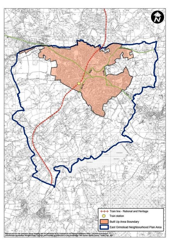
East Grinstead Neighbourhood Plan
                                                                      plan made November 2016

Figures

Figure 1    East Grinstead Neighbourhood Plan Area and Built Up Area Boundary

Figure 2    Landscape and Environmental Designations

Figure 3    East Grinstead Conservation Areas: (1) High Street and (2) East Court
            and Estcots

Figure 4    Housing Sites

Figure 5    Town Centre Boundaries and existing Central Pedestrian Areas

Figure 6    Ashdown Forest SPA – 7 km zone of influence

Figure 7    Railway Approach – Area Identified for Redevelopment

Figure 8    Queens Walk: Area Identified for Redevelopment

Figure 9    Imberhorne Lower School, Windmill Lane: Area Identified for
            redevelopment

Figure 10   Birches Industrial Estate

Figure 11   Charlwood’s Industrial Estate

Figure 12   Queen Victoria Hospital

Figure 13   St Margaret’s Loop

Figure 14   Land South of Birches Industrial Estate and West of Imberhorne Lane

                                            5
East Grinstead Neighbourhood Plan
                                                                    plan made November 2016

SCHEDULE OF POLICIES

TOWNWIDE POLICIES

Policy EG1     Protection of the High Weald AONB
Policy EG2     Areas of Development Constraint
Policy EG3     Promoting Good Design
Policy EG4     Heritage Assets
Policy EG5     Housing Proposals
Policy EG6A    Housing Sites with Planning Permission
Policy EG6B    Housing Sites – Allocated
Policy EG7     Housing Mix and Density
Policy EG8     East Grinstead Town Centre
Policy EG9     Temporary Community Uses
Policy EG10    Employment Provision
Policy EG11    Mitigating Highway Impacts
Policy EG12    Car Parking
Policy EG13    Embracing Modern Technology
Policy EG14    Protection of Open Space
Policy EG15    Alternative Sports Provision
Policy EG16    Ashdown Forest Protection

SITE SPECIFIC POLICIES

Policy SS1     Railway Approach
Policy SS2     Queens Walk
Policy SS3     Imberhorne School, Windmill Road
Policy SS4     Birches Industrial Estate
Policy SS5     Charlwood’s Industrial Estate
Policy SS6     Queen Victoria Hospital
Policy SS7     St. Margaret’s Loop
Policy SS8     Land South of Birches Industrial Estate and West of Imberhorne Lane

                                           6
East Grinstead Neighbourhood Plan
                                                                         plan made November 2016
1     INTRODUCTION
      The Context of the Neighbourhood Plan

1.1   The neighbourhood planning system presents an opportunity for local communities to
      create a new type of plan to deliver and regulate development within their area. The aims
      are to give local people the power to develop a shared vision for their neighbourhood and
      to deliver the sustainable development needed to ensure that the right type of
      development is created in the most suitable locations. It also provides the opportunity to
      develop specific planning policies to be used in determining planning applications.

1.2   The right for communities to prepare a Neighbourhood Plan was established through the
      Localism Act in 2011. Upon adoption of the East Grinstead Neighbourhood Plan it will
      become part of the statutory Development Plan for the district of Mid Sussex and will sit
      alongside higher order plans prepared by the District Council.

1.3   The Mid Sussex District Plan will remain the overriding strategy for the District and our
      Neighbourhood Plan must be in general conformity with the strategic objectives of the
      adopted development plan. Consequently this draft of the East Grinstead Neighbourhood
      Plan has been assessed and prepared against the 2004 Mid Sussex Local Plan: this
      being the adopted policy document for the District.

1.4   The District Council is reviewing the adopted plan and is in the early stages of preparing a
      new replacement plan to cover the period to 2031. A Pre-Submission draft of the plan was
      published in June 2105 and contains higher-level strategic policies for the District. Once
      the new plan has been formally adopted it will provide an updated framework for all
      planning documents, including our Neighbourhood Plan.

1.5   However, once the emerging District Plan has passed through the rigours of public
      examination and on to adoption, a review of our Neighbourhood Pan will be considered so
      that the document can be updated in light of any changes to the higher order plan. Under
      current legislation this will involve repeating the same process as this Plan – i.e. public
      consultation, examination and referendum.

1.6   Our plan must also comply with national planning policy set out in the National Planning
      Policy Framework (NPPF). Whilst this can be challenging, the preparation of the
      Neighbourhood Plan provides an exciting opportunity to inform and guide land use
      planning matters that are important to the community. It, therefore, provides a genuine
      opportunity to improve the built and natural environments in and around East Grinstead.
      That said it must be borne in mind that the Localism Act does not allow the Plan to take a
      negative stance or to prohibit development.

1.7   Finally, it is important to stress that Neighbourhood Plans must also comply with
      European Union regulations on strategic environmental assessment and habitat
      regulations and must be based on robust and realistic evidence.

      Why East Grinstead Needs a Neighbourhood Plan

                                            7
East Grinstead Neighbourhood Plan
                                                                           plan made November 2016

1.8    The Town Council has prepared a plan because of its heartfelt view that there is a need to
       consider all future development together rather than react to individual or piecemeal
       development proposals. We draw this conclusion because three important constraints
       seriously affect the amount of development, which the town can accommodate.

1.9    The first constraint is relevant to the character and high visual quality of the area, and in
       particular the surrounding countryside. Three particular, longstanding, land use
       designations restrict the potential for future development and growth to take place in East
       Grinstead in relation to the first constraint. Areas to the south and east of the town fall
       within the High Weald Area of Outstanding Natural Beauty (AONB), a nationally protected
       landscape where the primary purpose is to conserve and enhance natural beauty. The
       area to the west of the town between East Grinstead and Crawley, and the area to the
       east between East Grinstead and Ashurst Wood, have historically fallen within ‘strategic
       gaps’, whilst the area to the north of East Grinstead lies within the adjoining county of
       Surrey, where it forms part of the Metropolitan Green Belt.

1.10   The second constraint is significant and reflects the fact that East Grinstead lies within the
       7km zone of influence of the Ashdown Forest. Ashdown Forest is classified as a Special
       Protection Area (SPA) and designated as a Special Area of Conservation (SAC) and is,
       therefore, fully protected by the European Habitats Directive.

1.11   The third major constraint relates to infrastructure and, in particular, the road network. In
       2012 Atkins published the East Grinstead Traffic Management Study on behalf of West
       Sussex County Council. This study revealed that the A264 Copthorne Road is operating
       in excess of operating capacity during peak hours. The A22 through the town is also close
       to operating capacity and some of the junctions in excess of capacity. In November 2014,
       March and July 2015 reports prepared by Jubb on behalf of a local resident were
       published. These presented surveys and conclusions in relation to more recent survey
       data. This confirmed that all A22 junctions surveyed were operating on or over theoretical
       capacity. New highway provision and upgrading at East Grinstead has not kept pace with
       the rate of development and general traffic growth and the existing highway network is no
       longer able to cope with the traffic demands. Until significant improvements are made
       further large-scale growth will be extremely difficult to accommodate.

1.12   Whilst infrastructure improvements and environmental protection are our communities’
       key priorities, there are also other important issues that need to be addressed via the plan
       making process. The town centre is not realising its potential and is vulnerable to
       competition from out-of-centre facilities and other town centres: most notably Crawley and
       Tunbridge Wells. Likewise, a shortage of employment opportunities, a high office vacancy
       rate and low wages in relation to local house prices, all contribute to a high level of
       outward commuting. The Neighbourhood Plan aims to encourage an improvement to the
       town to meet the locally determined vision of a more self-sufficient and thriving
       community.

1.13   The cost of housing has risen to levels that make it increasingly difficult for young people
       and especially families to set up home independently and to remain in the town. An
       increase in the provision of housing is therefore needed and the Plan seeks to be as
       positive towards growth as it can be within the context of the above-mentioned
                                              8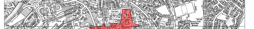
East Grinstead Neighbourhood Plan
                                                                          plan made November 2016
       constraints.

1.14   Finally, without a Neighbourhood Plan there is a danger that piecemeal development will
       continue without contributing to the improvement of infrastructure, or the quality of the
       town. The overarching vision, therefore, is to positively plan for and meet the needs and
       aspirations of the town’s residents, within the acknowledged environmental and
       infrastructure constraints and strained infrastructure of the town. In this particular case,
       the Neighbourhood Plan period will run between 2014 and 2031.

       How the Plan Was Prepared

1.15   The Town Council resolved to apply for a Neighbourhood Plan in May 2012, which was
       agreed by Mid Sussex District Council on 9th July 2012.

1.16   At the start of the process consultants (AR Urbanism) were appointed by the Town
       Council in July 2012 to assist with the preparation of the Plan. The consultants assisted
       with the initial drafting process, including discussions with a steering committee of the
       Council and were heavily involved in the early rounds of public consultation.

1.17   In advance of the formal consultation on the draft Plan, the programme of public
       engagement and consultation featured two stages; the first stage aimed at ensuring that
       the community was aware of the Neighbourhood Plan, what it is, what its role is and what
       could be achieved. It consisted of three surveys.

1.18   The second stage moved from awareness raising and construction of an evidence base,
       to more active involvement of the local community and consisted of two half-day
       workshops involving a wide range of parties representing different interests. To form this
       forum a number of community ‘gatekeepers’ were identified and contacted, who have
       access to, and influence on, larger community networks. This work of “community
       webbing” was aimed at ensuring that the widest possible cross-section of the community
       was involved in the process. The first workshop started with a broad scope and no formal
       plans, allowing discussion of what was valued about the town and how people would like
       to see it improved. Specific topics emerging from the first session were then explored in
       more depth in the subsequent workshop.

1.19   In addition to this main activity the steering group focused on schools as well. This was
       felt particularly important as the younger section of the population (or at least a part of
       them) are going to be the future residents of the town so their views are particularly
       valuable. In addition, capturing their views meant also capturing those of their families -
       another aspect of the community webbing technique.

1.20   A number of further meetings were organised with stakeholders. In this case the objective
       of the dialogue was to obtain a clearer picture on matters crucial to the emerging
       Neighbourhood Plan, including process as well as technical issues. These discussions
       included:

       •   Local transport and highways authority (West Sussex County Council) regarding the
           prospects and priorities for investment in and management of the road and transport
           facilities;
       •   The Planning Authority (Mid Sussex District Council) regarding a range of

                                             9
East Grinstead Neighbourhood Plan
plan made November 2016
neighbourhood planning and housing issues;
• The main provider of public transport (bus) services in the town (Metrobus);
• Provider of key walking and cycling routes such as Worth Way and Forest Way
(Sustrans).
1.21 Finally in Autumn of 2012 a website was set up, enabling people to contribute their views,
suggestions and concerns, find out about the Plan’s progress, and to provide a means of
building consensus. It was felt more appropriate to develop a website away from the
Council’s own, to reinforce the message that the Plan belongs to the community and thus
stimulate involvement.
1.22 Whilst good progress was made between 2012 and 2014, the Town Council had to take
the difficult decision to step back from the process and halt progress on preparation of the
Plan. This was a consequence of the experiences of other organisations including Mid
Sussex District Council and Slaugham Parish Council and the Town Council’s desire to
ensure that the plan stood the best possible chance of succeeding through the
preparation process.
1.23 As part of the review and to build on the work already carried out, planning consultants
Kember Loudon Williams LLP were appointed in September 2014 to further guide the
Town Council with the Neighbourhood Plan process. Since this time the Town Council
has revisited the findings of earlier consultations to ensure that the plan is founded on the
objectives and aspirations of residents and to ensure that the ‘objectives’ of the plan best
reflect the collective wishes of our community. In parallel, the Town Council and its
advisors have actively liaised with Mid Sussex District Council, and have received
valuable guidance and support in preparing the Neighbourhood Plan.
1.24 A Sustainability Appraisal was prepared which assesses the policies and objectives of the
plan and reviews the alternative solutions/options. In addition Mid Sussex District Council
will conduct an appropriate assessment of the East Grinstead Neighbourhood Plan. This
Sustainability Assessment has been undertaken at Regulation 14 and 16 Stages and will
be undertaken again prior to ‘making’ the plan in order to comply with the Habitat
Regulations. The next steps include:
Obtaining further views from the Community;
Amendments to the Plan;
Approval of the submission draft by East Grinstead Town Council
Submission to Mid Sussex District Council who will consult for a further six weeks
External examination
Referendum
Adoption
1.25 Between 27th July and 21st September 2015, the Town Council published a Consultation
version of the Neighbourhood Plan and also its Sustainability Appraisal. The consultation
resulted in around 170 respondents covering a whole range of policy matters. The Town
Council has reviewed each and where appropriate amended the Plan and also the
Sustainability Appraisal. The next stage will be to submit the amended Plan to Mid Sussex
District Council for final review against the relevant legislation before being consulted
upon and referred for independent examination.
10East Grinstead Neighbourhood Plan
plan made November 2016
How to read this Document
1.26 In order to achieve the above-mentioned objectives the Town Council has drafted a
number of policies that seek to achieve the outcomes our Community desires. These
policies will form part of the development plan for the area once the Plan is made and are
highlighted within the green text boxes.
East Grinstead Neighbourhood Plan Policy
1.27 As our Neighbourhood Plan must be consistent with national planning policy set out in the
NPPF there are certain core elements of these strategies that we have highlighted and do
not need repetition. The advice is included within the orange text boxes.
NPPF Planning Guidance (with which our plan must comply)
2 ABOUT EAST GRINSTEAD
11East Grinstead Neighbourhood Plan
plan made November 2016
2.1 East Grinstead is one of the three main towns in Mid Sussex with a population of over
28,500.
2.2 It is also one of the oldest towns in the County, and its importance as a market, industrial
and commercial centre dates back to medieval times. Its character and role has evolved
gradually over many centuries as economic and social circumstances have changed.
Nevertheless, it retains its historic core, centred on the High Street, where many buildings
date back as far as the 14th and 15th centuries and, in the majority of cases, are listed.
2.3 The town is set in very attractive countryside, which extends to the edges of the built up
area and includes, to the south and east, part of the High Weald Area of Outstanding
Natural Beauty. Ashdown Forest with its 25 square miles of wood and heathland is close
by.
2.4 The town has been developed on a flat-topped ridge, which extends from Ashurst Wood
in the southeast to Imberhorne Lane in the west. A ridge also extends along Holtye Road
to the northeast, and southwards towards Saint Hill Green. Steep-sided wooded river
valleys to the south of the town dissect these ridges. This physical form has given the
town a distinctive character and setting in relation to the surrounding area.
2.5 The town has direct rail access to Croydon and London, and is the northern terminus of
the Bluebell line, a preserved steam railway attraction. Passing through the town is
National Cycle Route 21, which uses the Worth Way to the west and Forest Way to the
southeast, providing a safe and attractive path for walkers and cyclists (including school
children) beyond the town. This route also forms part of the “Avenue Verte” international
route between London and Paris.
2.6 The town has predominantly a service economy, although there are also some industrial
and distribution businesses located mainly in the northern part of the town. There is a
wide range of cultural and sporting facilities, a regular farmers market and community
events. Figure 1 overleaf shows the Neighbourhood Plan area, which includes the town
and the rural areas to the west, east and south.
12East Grinstead Neighbourhood Plan
plan made November 2016
Figure 1 – East Grinstead Neighbourhood Plan Area & Built Up Area Boundary
13East Grinstead Neighbourhood Plan
plan made November 2016
3 OUR VISION AND OBJECTIVES
3.1 Following close examination of all public consultation responses to date the Town Council
has worked closely with the local community to develop a community vision for East
Grinstead.
Our Vision
‘To provide for a positive future for East Grinstead that is socially inclusive for all, vibrant,
economically robust and will allow residents to live with a high degree of self-sufficiency in
a town with a first rate natural, built and historic environment’.
3.2 In formulating this vision it has been made clear that the community requires coordinated
and well-planned development, in the right location, to help sustain one of the finest
historic market town environments in England. To do this we must balance the
considerations of the European Habitat Directives on Ashdown Forest and the
longstanding infrastructure limitations that have given rise to notable traffic congestion,
with the benefits of securing new investment in retail, employment, culture and community
activities with the cumulative aim of making East Grinstead a more attractive and pleasant
place to live and work.
3.3 The community wishes for priority to be given to addressing the persistent issue of traffic
congestion and delays on the main roads through the town, which acts as a constraint on
growth and investment. The approach to this is seen as being partly pragmatic traffic
management, but also the focusing of efforts to achieve more sustainable travel choices,
which will reduce the traffic burden and hence ease congestion. This Plan will outline
where new development can occur and the requirements necessary to meet such new
development. Once the basic highway conditions improve there will be greater scope and
desire to promote the growth needed to support future generations. Consequently land
has been identified with the potential to come forward for development in the future but
which is necessarily subject to the identified infrastructure and related constraints being
overcome.
3.4 Alongside creating a high quality place to live, our community wishes to maintain and
improve a town centre that it can be proud of and to attract visitors and investment to the
area.
3.5 We all attach great weight to the protection and improvement of the urban and rural
environment and the conservation of its natural and created resources. To us this means
resisting development that destroys or unacceptably damages the environment and
creating opportunities to remedy the underutilised areas of our town that could be better
improved through redevelopment.
3.6 Our community is keen to encourage high standards of design wherever new
development is proposed, and to reduce the negative impact of development to a
minimum. It also aims to conserve buildings of architectural and historic interest and to
14East Grinstead Neighbourhood Plan
plan made November 2016
preserve and enhance the special character and appearance of its conservation areas.
Finally we wish to safeguard open space as an important social and visual amenity, and
an integral part of the built environment.
Taking all of the above into consideration our Plan’s core objectives are to:
Improve the town’s urban, rural and historic environment and protect it from
harmful development;
Make prudent use of natural resources by promoting development on previously
developed sites within the built up area boundary;
Improve highway and infrastructure conditions, reduce the reliance on car use and
provide attractive alternative means of travel;
Provide quality new homes for existing and future residents within existing
environmental and infrastructure constraints;
Promote development that will provide sustainable economic growth, including
business and tourism related development and maintain a prosperous town centre;
and
Protect the countryside and urban open spaces for their landscape, wildlife,
agricultural, recreational and natural resource value, specifically including
Ashdown Forest and Areas of Outstanding Natural Beauty.
15East Grinstead Neighbourhood Plan
plan made November 2016
DEVELOPMENT POLICIES
16East Grinstead Neighbourhood Plan
plan made November 2016
4 CONSERVING EAST GRINSTEAD’S ATTRACTIVE ENVIRONMENT
4.1 East Grinstead has the benefit of being located in a spectacular location with quick and
easy access into London, making it an attractive place to live and work. However, it is the
town’s green surroundings that make it a particularly desirable location and, therefore,
preservation of these open areas is a key priority for the local community. The landscape
and environmental designations are presented below in figure 2 for ease of reference.
4.2 Three environmental designations restrict the potential for future development in East
Grinstead. Areas to the south and east of the town fall within the High Weald Area of
Outstanding Natural Beauty (AONB), the limits of which extend to the edges of the built up
area. The primary purpose of AONB designation is to conserve and enhance natural
beauty. Significant new development could prejudice this objective and would therefore be
inappropriate.
4.3 The area to the west of the town between East Grinstead and Crawley, and the area to
the east between East Grinstead and Ashurst Wood, has historically fallen within strategic
gaps. While not necessarily of the same high landscape quality as the AONB these areas
of countryside fulfill a vital role by preventing the coalescence of these settlements and
maintaining their separate identity. The policies in this plan therefore seek to strongly
discourage inappropriate development, which might contribute to coalescence and the
merging of settlements.
Figure 2 – Landscape and Environmental Designations
17East Grinstead Neighbourhood Plan
plan made November 2016
4.4 Finally, the area to the north of East Grinstead lies within the adjoining County of Surrey
where it is designated as Metropolitan Green Belt. Although outside of the scope of this
Neighbourhood Plan it does have an effect on the town by increasing the pressure for
new development within and on the town’s periphery.
Protection of the High Weald AONB
4.5 The extent of the High Weald AONB that affects East Grinstead is shown in Figure 2. The
character of the High Weald is contained in a pattern of distinctive ridged countryside and
hedged fields, together with scattered shaws and larger blocks of woodland. Large areas
remain quiet and unspoilt but are threatened by the cumulative impact of small-scale
development. That said it is not the purpose of this Plan to prevent agricultural
development needs or the sympathetic re-use of redundant rural buildings.
4.6 As the AONB offers both beauty and tranquility with magnificent views both towards and
away from the town, the Plan seeks to protect and manage the highest possible form of
protection from harmful development. We also wish to promote and conserve the locally
distinctive features of this part of the High Weald.
National Planning Policy states, at Paragraph 14, that there is a presumption in favour of
sustainable development. However, this presumption in favour is removed where a site lies
within the AONB and footnote 9 of NPPF confirms that this is the case.
National Planning Policy goes on to state at Paragraph 116 of the NPPF…
‘Planning permission should be refused for major developments in these designated areas
except in exceptional circumstances and where it can be demonstrated they are in the
public interest. Consideration of such applications should include an assessment of:
the need for the development, including in terms of any national considerations,
and the impact of permitting it, or refusing it, upon the local economy;
the cost of, and scope for, developing elsewhere outside the designated area, or
meeting the need for it in some other way; and
any detrimental effect on the environment, the landscape and recreational
opportunities, and the extent to which that could be moderated’.
4.7 Notwithstanding the Town Council and community’s desire to conserve and enhance the
AONB, the National Planning Policy Framework already provides a clear assessment of
how development proposals in the AONB should be considered and therefore this Plan
cannot impose a more onerous approach to restrict development. In the case of
development that is not defined as major (and this might include recreational proposals,
agricultural development and the conversion of existing buildings), the policy sets out a
series of criteria which must be met.
4.8 Nonetheless, Policy EG1 seeks to enhance the consideration given to applications in the
AONB by requiring a comprehensive assessment of any likely impact on features of the
AONB that are locally important.
18East Grinstead Neighbourhood Plan
plan made November 2016
EG1
Within the High Weald Area of Outstanding Natural Beauty planning permission will be
refused for major development proposals unless the development is demonstrably
required in the public interest and meets the exceptional circumstances criteria outlined
in the NPPF.
Planning permission for other forms of development will be granted where the proposals
are for the:
(i) Conversion of redundant buildings;
(ii) Replacement, on a like for like basis, of existing buildings; or
(iii) Extension of an existing dwelling house, relate to agricultural development or
some other minor recreational use;
Provided that for each of the above (i, ii and iii) all of the following criteria are met:
The highest standards of Design are achieved;
The natural and scenic beauty of the landscape is conserved or enhanced;
The proposals do not result in an obtrusive feature in the landscape.
The onus is on the applicant to demonstrate that the scheme would not negatively impact
on the existing quality of the protected landscape and its setting taking account of locally
important features. Proposals that have not fully considered and addressed the impact
on the AONB will normally be refused.
Countryside Area of Development Restraint
4.9 Since 2004 Strategic Gaps have been redefined as Countryside Area of Development
Restraint. This affects all land to the west, northwest and southwest of East Grinstead
outside of the built up area boundary. It specifically covers Hill Place Farm, the large
Imberhorne Lane and Farm sector, Great Wood, Tilkhurst Farm, Crockshed Wood, Furze
Field Wood plus the Crawley Down Road land areas on the border with Tandridge,
around Tandridge Water and the area towards Ashurst Wood, as shown on Figure 2.
4.10 The Town Council considers it important to protect such areas in order to ensure that
development does not result in the merging or coalescence of settlements and the
gradual accretion of development at the urban fringe.
Policy EG2 – Areas of Development Constraint
Planning permission will normally be granted for the sympathetic conversion of
redundant rural buildings, limited small-scale new development and extensions to
existing buildings within the Countryside Areas of Development Constraint
provided they comply with the following criteria:
(1) In the case of replacement dwellings, the proposal is no more obtrusive than
19East Grinstead Neighbourhood Plan
plan made November 2016
the dwelling it replaces and is of an appropriate design for its location and
setting;
(2) In the case of extensions, the proposal is subservient in scale and form to the
original dwelling along with the coherent use of materials;
(3) In the case of converted buildings, the new use has minimal impact on the
openness of the countryside, in terms of the new curtilage, and parking; in the
case of outdoor sport, recreation and community uses of land, the proposals
support the objective of keeping land open;
(4) The proposal comprises essential small-scale proposals for agricultural or
sport and recreation such as pavilions and changing rooms; or
(5) It is essential to meet specific necessary utility infrastructure needs and no
alternative feasible site is available.
Policy EG2a – Preventing Coalescence
Planning permission will not normally be granted for development which:
(1) Results in the coalescence of East Grinstead with Crawley Down or Ashurst
Wood;
(2) Results in the perception of openness being unacceptably eroded within this
area; or
(3) Contributes towards the ad hoc or isolated development of dwellings outside
the built up area, including infilling of built up frontages or linear
development along roads.
Promoting Good Design
4.11 As well as being critical to our community, one of the Government's core planning
principles is to always seek to secure high quality design and to protect the amenity of all
existing and future occupants of land and buildings.
National Planning Policy States at Paragraphs 56 and 57 of the NPPF…
‘The Government attaches great importance to the design of the built environment. Good
design is a key aspect of sustainable development, is indivisible from good planning, and
should contribute positively to making places better for people
It is important to plan positively for the achievement of high quality and inclusive design
for all development, including individual buildings, public and private spaces and wider
area development schemes’.
4.12 The Town Council fully endorses the Government’s position and believes that all
development should demonstrate high quality and compatibility with the area, whilst
demonstrably embracing sustainability principles. Following engagement with our local
community, detailed design criteria have been worked into a specific localised policy,
EG3.
Policy EG3 – Promoting Good Design
Planning permission will normally be granted where development proposals meet the
following criteria:
20East Grinstead Neighbourhood Plan
plan made November 2016
a) The form of the proposed development is proportionate and in keeping with the
scale, height, materials and site coverage of the surrounding area;
b) The layout of the proposed development respects the topography and
character of the site, protects important landscape features and does not harm
adjoining amenity;
c) The proposal does not result in the loss of buildings or spaces that would have
an unacceptable impact on the character of the area;
d) The proposal ensures satisfactory means of access for vehicles and
pedestrians and provides adequate parking, cycle storage and refuse facilities
on site;
e) The design of new buildings and the layout of spaces, including footways, car
and cycle parking areas, should be permeable and provide connectivity with
neighbouring areas;
f) New development must be inclusive and where appropriate make satisfactory
provision for the safe and easy access for those with mobility impairment; and
g) The design of new developments must result in the creation of a safe and
secure environment and incorporate adequate security measures and features
to deter crime, fear of crime, disorder and anti-social behaviour; and
h) Proposals make provision for green infrastructure and biodiversity
enhancement.
Due to infrastructure constraints within the town, all new development proposals, which
generate a net increase in traffic (excluding householder applications), will be required to
contribute towards improving the walking and cycle network related to the development
and be of a recognised acceptable standard.
Heritage Assets
4.13 'Heritage Assets' are valued components that make up the historic character of the town,
including important buildings, monuments, woodland, particular street scenes or areas,
and spaces or outstanding views. Within East Grinstead Heritage Assets include:
• Listed Buildings/structures;
• Conservation Areas;
• Ancient Woodland and Ancient Trees; and
• Areas of Outstanding Natural Beauty (AONB)
4.14 National legislation provides for the protection of Listed Buildings/Structures under the
Planning (Listed Buildings and Conservation Areas) Act 1990. There is a presumption in
favour of retaining Listed Buildings so permission to demolish will be the exception, and
only allowed if all other options to retain the building are demonstrated to have been
thoroughly explored.
4.15 Planning permission for alterations and extensions will be permitted where the proposal
would respect the original building’s scale, form, mass and appearance and would not
harm the historic importance of the building or its visual relationship with its setting.
4.16 Conservation Areas are designated on the basis of their overall quality, mix of uses,
historic layout, characteristic materials, scale and detailing of buildings and open spaces.
They also take into account the need to protect trees, hedges, walls, railings and other
characteristic features. Once designated, special attention must be paid in all planning
decisions to the desirability of conserving or enhancing its character and appearance.
21East Grinstead Neighbourhood Plan
plan made November 2016
4.17 The Conservation Area centered on the High Street (figure 3 refers) was originally
designated in 1969 and was identified as ‘outstanding’ by the Department of the
Environment in 1976. As well as the High Street it includes Middle Row, part of Ship
Street and West Street, and the east side of Church Lane. It was extended in 1985 to
include an area known as ‘The Portland’s’ to the south, and again in 2003 to include
properties on the west side of Ship Street. The High Street contains the longest
continuous run of 14th century timber-framed buildings in England. Other buildings date
from the 15th and 16th centuries, together with examples from the Georgian and Regency
periods. Particularly notable buildings include St Swithun’s Church and Sackville College,
the latter being a Grade I listed building dating from Jacobean times. Despite the intrusive
effects of traffic, the High Street has retained its outstanding distinctive and historic
character and appearance.
Figure 3 – East Grinstead Conservation Area (1) High Street and (2) East Court and Estcots
4.18 Land at East Court and Estcots, College Lane, was designated a Conservation Area in
2003 – figure 3 refers. The area includes East Court Mansion and its parkland, East Court
Lodge at the entrance to East Court and the area of Estcots Farmhouse, Estcots Barn
and Estcots Cottage. In particular the open rural quality of the area, the East Court Grade
II listed building, its attractive grounds and landscaped gardens contribute to the character
of this Conservation Area and its sensitive open setting.
National Planning Policy States at Paragraphs 132 of the NPPF…
‘When considering the impact of a proposed development on the significance of a
designated heritage asset, great weight should be given to the asset’s conservation. The
more important the asset, the greater the weight should be. Significance can be harmed or
lost through alteration or destruction of the heritage asset or development within its
22East Grinstead Neighbourhood Plan
plan made November 2016
setting. As heritage assets are irreplaceable, any harm or loss should require clear and
convincing justification. Substantial harm to or loss of a grade II listed building; park or
garden should be exceptional. Substantial harm to or loss of designated heritage assets of
the highest significance, notably scheduled monuments, protected wreck sites,
battlefields, grade I and II listed buildings, grade I and II registered parks and gardens, and
World Heritage Sites, should be wholly exceptional’.
4.19 In addition to the referencing the Conservation Areas and Listed Buildings/Structures, the
policy makes specific reference to the 'Portlands' area to the south of 58-84 High Street,
which has known archaeological interest. The area is identified in figure 3 and is a very
important legacy of the medieval layout of the town. There were originally forty-seven long
strips of land extending behind each property to the south of the High Street. Their
primary use was for domestic agriculture comprising mostly arable farming with some
animal husbandry. The Portlands began to be enclosed in the fourteenth century and
buildings were constructed on some of them. The section to the rear of numbers 58-84
represents the only surviving block of whole and undeveloped medieval Portlands within
the town and as such is an important surviving feature of the early urban landscape. Their
undeveloped character and appearance is an important visual feature of the town centre
and the High Street Conservation Area.
Policy EG 4 – Designated and Non Designated Heritage Assets.
Applications affecting designated and non-designated heritage assets must be
supported by an appropriately detailed assessment of their heritage
significance and the impact of the proposals on that significance.
EG4a
Proposals for development within The Portlands area of 58 to 84 High Street
will be subject to rigorous assessment having regard to their impact on the
area’s character and appearance, and the contribution of its archaeological
evidence to the special historic interest importance and contribution to the
significance of the Conservation Area, including the evidence of medieval
property boundaries and use for agricultural production.
4.20 The Bluebell Railway runs along the border between East and West Sussex and is an
important facility/feature for the local community and the town. The railway has been in
community use for many years, but the Grade II listed Imberhorne Viaduct and the
extension of the line to East Grinstead were only recently brought back into use in 2013.
The railway forms part of the Bluebell Railway Heritage Line and has historic significance
for the growth of East Grinstead. The Town Council will seek to protect it.
23East Grinstead Neighbourhood Plan
plan made November 2016
5 HOUSING IN EAST GRINSTEAD
5.1 East Grinstead is subject to a series of constraints. These include the effect of Ashdown
Forest and the Habitats Regulations Assessment, which affects new development both
individually and cumulatively, the role of the countryside in preventing coalescence, the
traffic and road conditions around the town that limits the amount of new development that
may be accommodated and the infrastructure needs generated by new development. As
a consequence, this section of the Plan will consider those sites, which can be allocated,
and whether there are any conditional requirements that must first be met before the sites
come forward for new housing.
5.2 In relation to Ashdown Forest a large area of land has been identified in the emerging Mid
Sussex District Plan as a Site for Suitable Alternative Natural Green Space (“SANG”).
This is located at East Court and Ashplats Wood to the east of the town. This SANG has
been assessed by the District Council in its Habitat Regulation Assessment. After
discounting pre-existing use of the site and based on a SANG standard of 8 ha per 1000
population, it is estimated that this SANG could provide capacity for a total of 1,507
dwellings to be accommodated across the 7km zone of influence (not just in the East
Grinstead Parish) as mitigation for potential recreational impact on Ashdown Forest.
Contributions towards Strategic Access Management and Monitoring (“SAMM”) strategy
will also be required.
5.3 Notwithstanding this, care needs to be taken over new development, not least because
the existing highway infrastructure is running at or close to operating capacity and in some
cases beyond operating capacity (see Atkins Report 2012, and the more recent three
Jubb Reports of 2014 and 2015). Policy EG5, therefore, provides a framework for how
housing proposals will be considered and, the criteria by which the Town Council would
expect the proposals to be judged. Policy EG6 is divided into two parts. EG6A outlines
those sites that already have planning permission, but which have not yet come forward.
In April 2015, 560 dwellings had full or outline planning permission in East Grinstead –
Appendix 2. EG6B identifies sites, which the Town Council would encourage to come
forward subject to appropriate mitigation. Of the EG6A and 6B sites the quantum of
housing is 515 dwellings over the life of the Plan, in accordance with the Mid Sussex
District Council Settlement Sustainability Appraisal February 2015. The sites are identified
in Figure 4, Housing Sites, on page 27.
Policy EG5 – Housing
The East Grinstead Neighbourhood Plan area is subject to significant environmental
and infrastructure constraints and as a result new housing development on land
defined as ‘previously developed,’ where the site is predominantly previously
developed or is green infrastructure that can be demonstrated to be surplus to
requirements will be supported subject to the criteria below and compliance with other
policies within the plan.
Other proposals for new housing development will only be supported if:
a) The proposed development contributes to sustainable development;
b) An application is supported by robust assessment of the environmental and
visual impact of the proposal and include as necessary appropriate mitigation
measures.
c) An application is supported by a robust assessment of the impact of the
24East Grinstead Neighbourhood Plan
plan made November 2016
proposal upon the local highway network and it can be demonstrated that the
proposal will not cause a severe cumulative impact in terms of road safety and
increased congestion after proposed mitigation is taken into account;
d) The proposal complies with design guidance contained in policy EG3 or a
relevant Development Brief;
e) The proposal provides a mix of tenure types including private, social rented and
shared equity (intermediate);
f) Contributions are made towards SANG and Strategic Access Management and
Monitoring (SAMM); and
g) The proposal meets its own infrastructure needs.
Where proposals comply with Policy EG5, relevant site-specific policies and mitigate
their highway and other infrastructure impacts, the following sites (EG6A and EG6B)
will be encouraged to come forward for residential development.
Policy EG6A – Housing Sites that are committed via planning permissions
1. St Lukes House and St Lukes Church, Holtye Avenue (0.14ha, Shlaa ref 439). This
site has been previously promoted for development but proposals will need to
justify the loss of this piece of community infrastructure. A development similar in
scale to the new apartments opposite could be developed. Development should not
exceed three storeys and two storeys near adjoining houses. A suitable soft
landscaping and boundary treatment, consisting of native species, will be required
along the southern boundary to provide appropriate screening in order to protect
neighbouring residential amenity. The site could achieve up to 15 units and
permission was granted under 12/00439/FUL for 14 units.
2. 1-25 Bell Hammer (0.35ha, Shlaa ref 696). This site has an extant planning
permission (13/01343/FUL for 28 sheltered housing units but could be suitable for
housing.
3. Warrenside, College Lane (0.17ha, Shlaa ref 444). An existing dwelling adjacent to
Beeching Way. Scope exists for 14 units subject to important trees being protected
and the amenity of residents adjoining the site. Outline permission granted
12/01877/OUT.
Policy EG6B – Housing Sites which could be brought forward include:
4. Meadway Garage, Lowdells Lane (0.16ha, Shlaa ref 324). This site has some tree
coverage but historically was used as a garage. It is now redundant and dilapidated.
To conform to the character of the area some 9 dwellings is considered appropriate
in two storey buildings.
5. Land at junction of Windmill Lane and London Road (0.4ha, Shlaa ref 102). This site
is on a prominent corner where a flatted scheme would be appropriate. The scale of
the development should not exceed 3 storeys in height and frontage trees of
significance should be retained. This site could achieve 30-35 dwellings and is
identified in the Small-scale Housing Allocation Document (SSH/2).
6. Imberhorne Lane Car park (0.18ha, Shlaa ref 510). The redevelopment of this site is
subject to evidence being submitted that the car park is no longer needed. A flatted
scheme providing up to 18 dwellings would be suitable. Two storey buildings would
be an appropriate scale of development, although if a higher scale building were
proposed a visual and amenity impact assessment would be required.
7. 67-69 Railway Approach (0.09ha, Shlaa ref 441). This site is subject to a site specific
Policy SS1. It could accommodate up to 7 units.
8. Post Office and delivery office, 76 London Road (0.15ha, Shlaa ref 559). This is a
listed building with a much later extension and service yard at the rear.
Development for up to 12 dwellings would be supported subject to (i) a ground floor
25East Grinstead Neighbourhood Plan
plan made November 2016
retail use on the London Road frontage and (ii) the removal of the rear brick
extension which detracts from the listed frontage.
9. Cantelupe House, Cantelupe Road (Shlaa ref 608) An older 1960’s office building of
limited architectural merit. Close to existing residential units. Given its elevated
position a maximum of 3-Storeys would be appropriate. Designs should reflect the
Victorian character of the residential street. The number of units could be 10-12
depending on design.
10. Imberhorne Lower School, Windmill Lane (7ha, Shlaa ref 81). This site is subject to
Policy SS3. Subject to Policy EG5 relating to highway infrastructure mitigation, the
site could accommodate circa 200 dwellings. Prior to planning permission being
granted a development brief should be prepared, consulted upon and adopted. The
Town Council, with stakeholders, proposes to take a lead on its preparation.
11. Ashplats House, off Holtye Road. This site would be suitable for between 35 and 45
dwellings being that it is now surrounded on 3 sides by existing development and
partly constitutes previously developed land. Access Could be appropriate off
Greenhurst Drive.
12. Queens Walk between Queensway and London Road. This site is subject to pre-
application discussion and the owners have confirmed their intention to deliver a
mixed-use scheme. The site could achieve up to 120 dwellings subject to design
and mix use considerations.
26East Grinstead Neighbourhood Plan
plan made November 2016
Figure 4 - Housing Sites
27East Grinstead Neighbourhood Plan
plan made November 2016
Summary Table for Policies EG6A and 6B
Site Dwelling number
1 St Lukes Hospital and Church 15
2 1-25 Bell Hammer 28
3 Warrenside 14
4 Meadway Garage 9
5 Windmill Lane/London Road 35
6 Imberhorne lane car park 18
7 67-69 railway Approach 7
8 Post Office 12
9 Cantelupe House 12
10 Imberhorne Lower School 200
11 Ashplats House 45
12 Queens Walk 120
Total 515
Housing Mix and Density
5.4 With land resources being finite and infrastructure being at capacity it is important that any
new homes that do come forward meet the needs of both current and future residents.
This will include affordable housing in line with adopted development plan policy. It is
therefore important not only that housing is designed to a high quality and creates an
attractive environment but also they represent the types of homes where people want to
live.
National Planning Policy States at Paragraphs 50 of the NPPF…
‘To deliver a wide choice of high quality homes, widen opportunities for home ownership
and create sustainable, inclusive and mixed communities, local planning authorities
should:
Plan for a mix of housing based on current and future demographic trends, market
trends and the needs of different groups in the community (such as, but not limited
to, families with children, older people, people with disabilities, service families
and people wishing to build their own homes); and
Identify the size, type, tenure and range of housing that is required in particular
locations, reflecting local demand’.
5.5 Over the recent past a significant number of large family dwellings and small flats have
been built. The latter have been influenced, particularly, by the changes to the permitted
development regime that enable offices to be converted to residential use without the
need for formal planning permission. This has created a further 219 apartments within
East Grinstead and the plan area.
5.6 Whilst smaller flats and apartments continue to be appropriate in certain locations, such
as the Town Centre, the District Council’s Housing and Economic Development Needs
28East Grinstead Neighbourhood Plan
plan made November 2016
Assessment (HEDNA), dated March 2015, also notes that by 2031 there will be a higher
proportion of older people in the District and, whilst some younger age groups are
predicted to grow, the overall age profile is ageing (Figure 26 of the HEDNA refers). The
HEDNA notes that the District has a below average proportion of single person
households but there is growth in single person households (paragraph 4.118 to 4.119 of
the HEDNA). The HEDNA notes at Table 28 that Mid Sussex has the lowest stock of 1-2
bedroom dwellings and 2-3 bed dwellings are also below the West Sussex, South East
and England average. Family homes that are larger executive homes of 4 + bedrooms are
well above the West Sussex, South East and England average. Consequently, it is
considered appropriate to encourage smaller homes through Policy EG7.
Policy EG7 – Housing Mix and Density
Planning permission will be granted for new housing schemes where they meet the
following criteria:
(1) Achieve a minimum density of 30 dwellings per hectare unless local character
indicates a different density level and this justification is provided;
(2) On sites of 5 or more dwellings, provide a minimum of 20% small family
accommodation in the form of 2 and 3 bedroom units;
(3) Variations in the above mix will only be considered where a viability assessment
has been provided to justify a departure from this policy or there are clear design
and location reasons which indicate a higher density is appropriate; and
(4) Provides affordable housing in accordance with District policy.
29East Grinstead Neighbourhood Plan
plan made November 2016
6 BUSINESS AND RETAILING IN EAST GRINSTEAD
6.1 East Grinstead is the most important retailing centre in the northern part of Mid Sussex. It
provides a range of shops in both the food and non-food retail sectors.
6.2 The main shopping frontage is in London Road between the High Street and King Street
junctions, and includes a small-pedestrianised area, Queens Walk. To the north of King
Street, London Road and Railway Approach comprise an important secondary shopping
area, while the High Street, the historic core of the town and a Conservation Area,
provides a very attractive area of shopping mixed with a range of other uses.
6.3 East Grinstead performs relatively well with vacancy rates low and a steady demand for
premises from prospective retailers. However, continued enhancement and promotion of
the town centre is very important to residents, and the business community, who seek to
further encourage the vitality and viability of East Grinstead town centre through improved
access for pedestrians, civic landscaping, management and diversification, and looks to
retain and broaden the range of shopping facilities.
Figure 5 – Town Centre Boundaries and existing Central Pedestrian Areas
6.4 With this in mind, the Plan seeks to encourage a strong retail offer within primary
shopping areas, and some degree of flexibility in the types of uses that could move in to
secondary and other town centre areas. Upper floors are considered to offer plenty of
scope and the Town Council is keen to encourage a flexible approach to the type of uses
on upper floors.
30East Grinstead Neighbourhood Plan
plan made November 2016
The Town and Country Planning (Use Classes) Order 1987 (as amended) puts uses of land
and buildings into various categories known as 'Use Classes'.
The following list gives an indication of the types of use that may fall within each use class
in order to better aid the understanding of policy EG8.
A1 Shops - Shops, retail warehouses, hairdressers, undertakers, travel and ticket
agencies, post offices (but not sorting offices), pet shops, sandwich bars,
showrooms, domestic hire shops, dry cleaners, funeral directors and internet
cafes.
A2 Financial and professional services - Financial services such as banks and
building societies, professional services (other than health and medical services)
including estate and employment agencies and betting offices.
A3 Restaurants and caf„s - For the sale of food and drink for consumption on the
premises - restaurants, snack bars and cafes.
A4 Drinking establishments - Public houses, wine bars or other drinking
establishments (but not night clubs).
A5 Hot food takeaways - For the sale of hot food for consumption off the premises.
B1 Business - Offices (other than those that fall within A2), research and
development of products and processes, light industry appropriate in a residential
area.
B2 General industrial - Use for industrial process other than one falling within class
B1 (excluding incineration purposes, chemical treatment or landfill or hazardous
waste).
B8 Storage or distribution - This class includes open-air storage.
C1 Hotels - Hotels, boarding and guesthouses where no significant element of care
is provided (excludes hostels).
C2 Residential institutions - Residential care homes, hospitals, nursing homes,
boarding schools, residential colleges and training centres.
C3 Dwelling houses
C4 Houses in multiple occupation - small shared houses occupied by between
three and six unrelated individuals, as their only or main residence, who share
basic amenities such as a kitchen or bathroom.
D1 Non-residential institutions - Clinics, health centres, cr…ches, day nurseries, day
centres, schools, art galleries (other than for sale or hire), museums, libraries,
halls, places of worship, church halls, law court. Non-residential education and
training.
D2 Assembly and leisure - Cinemas, music and concert halls, bingo and dance
halls (but not night clubs), swimming baths, skating rinks, gymnasiums or area for
indoor or outdoor sports and recreations (except for motor sports, or where
firearms are used).
31You can also read


