Metro EXTRA Service Plan - District of Columbia Rapid Bus Study
←
→
Page content transcription
If your browser does not render page correctly, please read the page content below

Metro EXTRA Service Plan

                       Georgia Avenue – 7th Street Corridor

District of Columbia
 Rapid Bus Study

                                 November 2006
LIST OF EXHIBITS                                                                                                            TABLE OF CONTENTS

Section 1: Existing Conditions………………………………………………………....... .1                                        Section 1: E xisting C onditions ................................................................................................................ 1
 Exhibit 1: Georgia Avenue-7 th Street Corridor……………………………………………………………..…..1                            Roadway Configuration................................................................................................................................. 1
                                                                  th
 Exhibit 2: Roadway Width and Lane Configuration, Georgia Avenue-7 Street Corridor…………….…...2           Traffic Conditions........................................................................................................................................... 1
 Exhibit 3: Weekday Traffic Volumes…………………………………………………………………..........…...3                             Existing Transit Service................................................................................................................................. 4
 Exhibit 4: Level of Service.…………………………………………………………………………….………....3
 Exhibit 5: Bus Routes 70, 71.……………………………………………………………………………...………4
                                                                                                     Section 2: Metro EXTRA Service Plan for Georgia Avenu e-7 th Street N W C orridor.... 12
 Exhibit 6: Existing Boardings and Destinations.…………………………………………………………... ……5
 Exhibit 7: Area Not Served by Existing Metro.………………………………………………………………….5
                                                                                                        Service Concept.............................................................................................................................................12
 Exhibit 8: Weekday Boardings by Stop, Route 70-71………………………………………………………...…6                            Vehicles...........................................................................................................................................................12
 Exhibit 9: Boarding and Alighting Activity, Route 70-71 (Northbound)………………………………………7                   Stop Locations ...............................................................................................................................................14
 Exhibit 10: Boarding and Alighting Activity, Route 70-71 (Southbound)………………………………..……8                 Running Way Improvements......................................................................................................................20
 Exhibit 11: Peak Hour, Peak Direction Bus Load Levels, Route 70-71……………………………….….…....9                Travel Speed and Travel Time ...................................................................................................................21
 Exhibit 12: Weekday Transit Travel Speed, Route 70-71………………………………………………..……10                          Ridership ........................................................................................................................................................21
 Exhibit 13: Travel Time between Timepoints and Travel Speed by Time of Day (Northbound)……..……11        Operating Costs.............................................................................................................................................21
 Exhibit 14: Travel Time between Timepoints and Travel Speed by Time of Day (Southbound)………..…11        Capitol Costs..................................................................................................................................................22

Section 2: Metro EXTRA Service Plan…………………………………………………..12                                           Appendix A: Georgia Avenue-7th Street Corridor Proposed Rapid Bus Service
 Exhibit 15: Georgia Avenue-7th Street NW Corridor Metro EXTRA Service Plan.…….……......12            Appendix B: Georgia Avenue-7th Street Corridor Pictures of Existing Conditions at Stop Locations
 Exhibit 16: Georgia Avenue-7 th Street Proposed ‘Metro EXTRA’ Rapid Bus Service…….……..13
                                                                                                     Appendix C: Georgia Avenue-7th Street Corridor Requested Stop Improvements
 Exhibit 17: Georgia Avenue-7th Street NW Corridor Metro EXTRA “Strip Map”……………...14
 Exhibit 18: Georgia Avenue-7 th Street Corridor, Proposed Rapid Bus Stops………………..........15
 Exhibit 19: Georgia Avenue-7th Street Proposed Metro EXTRA Stop Requirements for Short Term….….19
 Exhibit 20: Estimated Rapid Bus Speed and Travel Time…………………………………..…........21
 Exhibit 21: Operating Statistics for Georgia Avenue-7 th Street Metro EXTRA Service……..…...22
 Exhibit 22: Georgia Avenue-7 th Street Capital Costs……………………………………………......23

                                                                                                                                                                                                                                                                         i
Section 1: Existing Conditions                                               Traffic Conditions

The Georgia Avenue-7 th Street Corridor is defined as the following streets:                                    Exhibit 2 shows the roadway configuration in terms of the number of lanes, right of way widths, and
                                                                                                                parking regulations along the corridor. Exhibit 3 shows the average daily traffic volumes in the corridor.
       7th Street NW between Pennsylvania Avenue NW and Florida Avenue NW                                       The exhibit shows that the highest volumes are in the northernmost part of the corridor, where it crosses
                                                                                                                into the District from Montgomery County. South of Piney Branch Road, the traffic volume begins to
       9th Street NW between M Street NW and Pennsylvania Avenue NW
                                                                                                                drop as traffic diverts onto other major north-south roadways, including Piney Branch Road, 13 th Street,
       Georgia Avenue NW between Florida Avenue NW and Eastern Avenue NW                                        and New Hampshire / Sherman Avenue. By the time 7th Street reaches downtown Washington, traffic
       A possible extension via Georgia Avenue and Wayne Avenue to Silver Spring Metro                          volumes are relatively light, as the roadway operates in a grid street network with numerous parallel
                                                                                                                alternative routes; and as the level of service on Metrobus and Metrorail modes increase.
Roadway Configuration
                                                                                                                This traffic pattern is reflected in the roadway Level of Service (LOS), shown in Exhibit 4. The
Roadways in the study corridor are primarily 2-way, although 9 th Street is a one way (southbound) street       northernmost segment of Georgia Avenue – north of Piney Branch Road – has a LOS F, as this segment
between Mount Vernon Place NW and Pennsylvania Avenue NW.                                                       carries the heaviest traffic on the roadway. Traveling south, the roadway functions at LOS D or better on
                                                                                                                all segments north of the downtown area. In downtown Washington, even thought the traffic counts are
Land uses along 7 th Street and Georgia Avenue are primarily commercial, and vary from high density in          relatively low, the LOS returns to F, reflecting the relatively narrow roadway and the impacts of signalized
the downtown area (roughly south of Mount Vernon Place) to small-scale, neighborhood commercial in              intersections at every block.
the northern sections of the alignment. Major trip attractors along the corridor include:
                                                                                                                                            Exhibit 1: Georgia Avenue-7 th Street Corridor
       Downtown Washington
          o Chinatown
          o The Verizon Center
       The Washington Convention Center
       Howard University
       The Howard University Medical Center
       Walter Reed Medical Center
       Downtown Silver Spring

The alignment crosses six Metrorail stations:
       Archives-Navy Memorial-Penn Quarter (Green & Yellow Line)
       Gallery Place-Chinatown (Green, Yellow & Red Line)
       Mount Vernon Square-Convention Center (Green & Yellow Line)
       Shaw-Howard U (Green Line)
       Georgia Avenue-Petworth (Green Line)
       Silver Spring (Red Line)

The alignment is shown in Exhibit 1.

Exhibit 2 shows that there is curbside parking in at least some time periods for most of the corridor. This
curbside parking is primarily utilized by the small-scale businesses that line Georgia Avenue and 7 th Street
for most of their lengths. Larger businesses like supermarkets tend to have their own parking lots located
off-street. There is limited residential development, which mostly has access to rear alleys for parking.
Much of the on-street parking is metered, with two-hour time limits.

                                                                                                                                                                                                                         1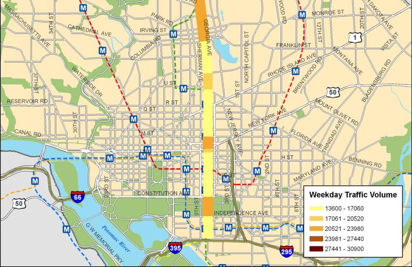
Exhibit 2: Roadway Width and Lane Configuration, Georgia Avenue-7 th Street Corridor

                                      Segment                       ROW          Curb to    One Way?       Travel Lanes        Parking Lanes       Parking Restrictions      1998     Pe ak Hour   Peak Hr
      Street
                          Begin                     End            Width (Ft)   Curb (Ft)     (Y/N)       NB          SB       NB        SB           NB          SB        AWDT       Volume       LOS

Georgia Ave. NW   Eastern Avenue         Shepherd Road                 90          60          N           3           3       -           -      No Parking   No Parking   30,900      1,724         F

Georgia Ave. NW   Shepherd Road          Piney Branch Road             90          60          N           2           2       1          1        Metered      Metered     30,900      1,724         F

Georgia Ave. NW   Piney Branch Road      Missouri Avenue               90          60          N           2           2       1          1        Metered      Metered     24,100      1,345        D

Georgia Ave. NW   Missouri Avenue        Buchanan Street               90          60          N           2           2       1          1        Metered      Metered     22,700      1,267        D

Georgia Ave. NW   Buchanan Street        Quincy Street                 90          56          N           2           2       1          1        Metered      Metered     22,500      1,256        D

Georgia Ave. NW   Quincy Street          Irving Street                 90          60          N           2           2       1          1        Metered      Metered     23,000      1,283        D

Georgia Ave. NW   Irving Street          Harvard Street                90          56          N           2           2       1          1        Metered      Metered     21,600      1,205        D

Georgia Ave. NW   Harvard Street         Bryant Street                 90          54          N           2           2       1          1        Metered      Metered     15,500       865         D

Georgia Ave. NW   Bryant Street          Florida Avenue                90          49          N           1           1       1          1        AM/PM        AM/PM       18,200      1,016         F

Seventh St. NW    Florida Avenue         Rhode Island Avenue           85          50          N           1           1       1          1        AM/PM        AM/PM       15,100       843          F

Seventh St. NW    Rhode Island Avenue    Q Street                      85          50          N           1           1       1          1        Metered      AM/PM       15,100       843          F

Seventh St. NW    Q Street               N Street                      85          50          N           1           1       1          1        Metered      Metered     15,100       843          F

Seventh St. NW    N Street               Mt Vernon P lace              85          50          N           2           1       1          1        Metered      Metered     22,700      1,267         F

Seventh St. NW    Mt. Vernon P lace      Mass Avenue                   85          62          N           4           1       -           -      No Parking   No Parking   17,900       999         D

Seventh St. NW    Mass. Avenue           D Street                      85          50          N       1+1 transit     1       1          1        Metered      AM/PM       14,500       809          F

Seventh St. NW    D Street               Penn Avenue                   85          51          N       1+1 transit     1       1          1        Metered      AM/PM       14,100       787          F

Seventh St. NW    Penn Avenue            Constitution Avenue           85          70          N           2           2       1          1        AM/PM        AM/PM       13,900       776         D

Seventh St. SW    Constitution Avenue    Independence Avenue          132          76          N           3           3       1          1        AM/PM        AM/PM       21,400      1,194        D
                  Independence
Seventh St. SW                           C Street                      85          64          N           2           2       1          1        Metered      Metered     13,600       759         D
                  Avenue
Ninth St. NW      N Street               Mt. Vernon P lace          No Data      No Data       Y           2           2       1          1        Metered      Metered     No Data    No Data     No Data
                                                                                                                       2+1                4+1
Ninth St. NW      Mt. Vernon P lace      New York Avenue            No Data      No Data       Y            -                  -                   Metered      Metered     No Data    No Data     No Data
                                                                                                                     transit            transit
                                                                                                                       2+1                2+1
Ninth St. NW      New York Avenue        Pennsylvania Avenue        No Data      No Data       Y            -                  -                   Metered      Metered     No Data    No Data     No Data
                                                                                                                     transit            transit

                                                                                                                                                                                                             2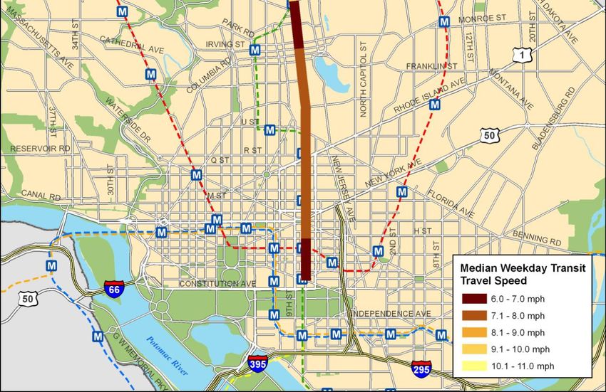
Exhibit 3: Weekday Traffic Volumes                                                Exhibit 4: Level of Service

Source: 1998 Traffic Counts cited in the DC Transit Development Study      Source: 1998 Traffic Counts cited in the DC Transit Development Study; LOS Calculation: ITE traffic Manual

                                                                                                                                                                                        3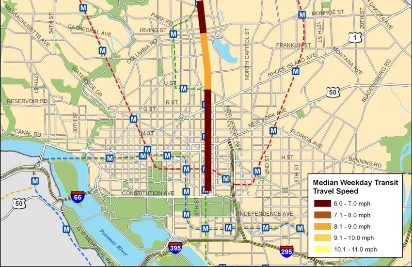
Existing Transit Service                                                                                  Exhibit 5: Bus Routes 70, 71

Transit in the Georgia Avenue-7 th Street Corridor is primarily provided by Metrobus Route 70-71. Route
70-71 is shown in Exhibit 5.

Route 70-71 operates between Silver Spring Metro in the north and four different southern terminals:

       L’Enfant Plaza
       Maine Avenue / 9 th Street SW
       Pennsylvania Avenue / 9 th Street NW
       Half Street / O Street SW

Service operates 7 days a week between 4:00 a.m. and 2:00 a.m. Trunk line headways are about 7-10
minutes in the peak (when both the 70 and the 71 routes operate) and about 10 minutes in the midday
period (when just the 70 runs).

Route 70-71 is one of the busiest and most crowded Metrobus routes:
       There are about 17,000 daily boardings between Eastern Avenue and Archives
       There are about 22,000 daily boardings between Silver Spring and Buzzard’s Point
       The highest load factor on the route is about 0.89, at Georgia Avenue / Irving Street

Challenges:

The purpose of the Rapid Bus Implementation Plan is to address several of the challenges faced by
existing transit operations in the Georgia Avenue-7 th Street Corridor, including:

       Long travel times due to slow travel speeds and intersection signal delay
           o The roadway operates at level of service F south of Florida Avenue and north of Piney
               Branch Road
           o Between Petworth and Irving, transit speeds are below 8 mph all day
           o The total trip average speed is below 10mph for all southbound midday and PM peak trips,
               and all northbound AM peak, midday, PM peak and evening trips
       Poor schedule adherence (reliability)
           o 22% of southbound trips are more than 5 minutes late
           o 33% of northbound trips are more than 5 minutes late
       Insufficient capacity
           o Peak period, peak direction load factors exceed 0.8 in both directions
           o The most crowded point is Irving Street, with a load factor of 0.89
       Imbalance of service between the northern and southern ends of the existing 70-71 routes
           o There are too many trips to Buzzard’s Point for the service demand in the area
       Limited passenger amenities at stops
           o Most stops lack shelters and benches; no stops have real time bus arrival information

                                                                                                                                         4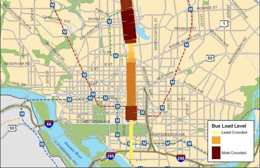
Exhibit 6: Existing Boardings and Destinations                                                                Exhibit 7: Area Not Served by Existing Metro

                                                                                                               The following exhibits show current conditions for transit service along Route 70-71:
                                                                th
Existing origin and destination data for the Georgia Avenue-7 Street Corridor are shown in Exhibit 6.                 Exhibit 8 graphically shows the locations of the busiest boarding locations along the route
The pattern suggests lots of short trips within the corridor, rather than the longer trips characteristic of          Exhibit 9 and 10 lists all of the stops along the route and the total number of boardings and
Metrorail lines. Many of the trips may be between areas unserved by Metrorail and one of the stops along              alightings at each location
the route; much of the northern end of Georgia Avenue NW is unserved by Metrorail, as shown in Exhibit                Exhibit 11 shows the bus load levels during the peak period
7.                                                                                                                    Exhibit 12 shows the weekday transit travel speeds for Route 70-71
                                                                                                                      Exhibits 13 and 14 show the travel time and speed between time points along the route

                                                                                                                                                                                                                5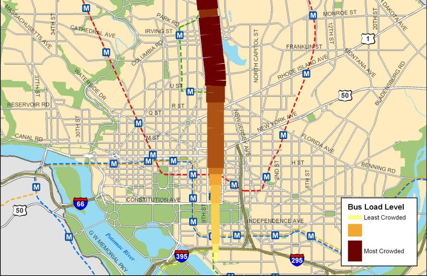
Exhibit 8: Weekday Boardings by Stop, Route 70-71

Source: WMAT A Ride check 2005

                                                                                     6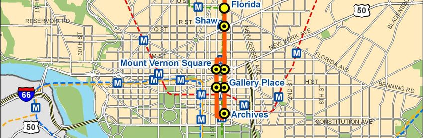
Exhibit 9: Boarding and Alighting Activity, Route 70-71 (Northbound)
Total Weekday Boardings+ Rank Boardings+
On Street Cross Street
Boardings Alightings Alightings Boardings Alightings Alightings
ND
V ST SW BET 2 & 1 STS ( TP-71 PM) 39 - 39 58 72 67
WATER ST SW BET HALF & T STS ( PM) - - - 77 72 78
WATER ST SW BET T & S STS ( TP-71) 14 - 14 72 72 75
FIRST ST SW Q ST 11 - 11 75 72 77
FIRST ST SW P ST 42 1 43 55 68 64
HALF ST SW O ST ( TP-70) 170 6 176 18 63 41
P ST SW FIRST ST 29 6 35 65 63 69
P ST SW CANAL ST 34 4 38 62 65 68
RD
P ST SW 3 ST 20 1 21 69 68 72
TH
P ST SW 4 ST 33 9 42 64 62 65
TH
4 ST SW O ST (S) 17 1 18 70 68 73
TH
4 ST SW N ST 12 1 13 74 68 76
TH
4 ST SW M ST 64 61 125 44 50 55
TH
M ST SW 6 ST 29 3 32 65 66 70
TH
6 ST SW K ST 23 17 40 68 59 66
TH
I ST SW 7 ST 36 12 48 61 61 62
TH
MA INE AVE SW 9 ST (TP-70) 65 - 65 43 72 61
TH
G ST SW 7 ST - - - 77 72 78
TH
7 ST SW G ST 26 3 29 67 66 71
TH
D ST SW 7 ST (TP-70) 46 - 46 51 72 63
TH ST
7 ST SW E ST (1 STOP) (TP) 426 53 479 6 53 9
TH
7 ST SW MA RYLAND AVE 118 14 132 28 60 50
TH
7 ST SW INDEPENDENCE AV E 165 58 223 19 52 36
TH
7 ST NW CONSTITUTION AV E 80 23 103 38 58 58
TH
9 ST NW CONSTITUTION AV E (TP) 15 - 15 71 72 74
TH
7 ST NW PENNSYLVANIA AVE (TP) 643 100 742 4 37 8
TH
7 ST NW E ST 161 67 227 20 48 35
TH
7 ST NW G ST 188 45 232 14 54 33
TH
7 ST NW H ST (TP) 1,320 398 1,718 1 5 1
TH
7 ST NW MASSA CHUSETTS AVE 129 30 159 23 57 45
TH
7 ST NW L ST 43 37 80 52 55 59
TH
7 ST NW M ST 190 80 270 13 41 29
TH
7 ST NW N ST 58 69 127 46 45 53
TH
7 ST NW O ST 72 115 187 41 34 40
TH
7 ST NW P ST 220 200 420 12 20 13
TH
7 ST NW RHODE ISLAND AV E 253 175 428 10 23 10
TH
7 ST NW S ST 341 59 399 9 51 14
TH
7 ST NW FLORIDA AVE (TP) 963 372 1,334 2 6 3
GEORGIA AVE NW V ST X 227 122 349 11 32 18
GEORGIA AVE NW W ST 96 68 163 31 47 43
GEORGIA AVE NW BARRY PL X 182 136 318 15 27 25
GEORGIA AVE NW HOWA RD PL 42 33 75 55 56 60
GEORGIA AVE NW EUCLID ST 179 243 422 16 13 12
GEORGIA AVE NW GRESHA M PL X 119 182 301 26 22 26
GEORGIA AVE NW IRV ING ST 488 415 903 5 4 6
GEORGIA AVE NW LAMONT ST X 128 214 341 24 16 21
GEORGIA AVE NW PA RK RD 144 205 349 21 18 17
GEORGIA AVE NW OTIS PL X 57 79 136 47 42 49
GEORGIA AVE NW N. HA MPSHIRE AV E (N/N) ( TP) 349 568 917 8 2 5
GEORGIA AVE NW N. HA MPSHIRE AV E (N/F) 798 250 1,048 3 12 4
GEORGIA AVE NW RANDOLPH ST 136 128 264 22 29 30
GEORGIA AVE NW SHEPHERD ST 51 75 126 49 43 54
GEORGIA AVE NW UPSHUR ST 173 253 426 17 11 11
GEORGIA AVE NW WEBSTER ST 83 129 212 35 28 37
GEORGIA AVE NW BUCHA NAN ST 40 124 164 57 31 42
GEORGIA AVE NW DECA TUR ST 81 201 282 36 19 28
GEORGIA AVE NW EMERSON ST 43 81 124 52 40 56
GEORGIA AVE NW FARRAGUT ST 34 95 129 62 38 51
GEORGIA AVE NW GALLATIN ST 60 68 128 45 46 52
GEORGIA AVE NW INGRAHA M ST 77 214 291 40 16 27
GEORGIA AVE NW KENNEDY ST ( TP) 350 538 888 7 3 7
GEORGIA AVE NW MA DISON ST 85 170 254 34 25 32
GEORGIA AVE NW MISSOURI AVE 37 298 335 60 9 23
GEORGIA AVE NW QUACKENBOS ST 88 256 344 33 10 19
GEORGIA AVE NW RITTENHOUSE ST 100 242 342 30 14 20
GEORGIA AVE NW TUCKERMA N ST 127 226 353 25 15 16
GEORGIA AVE NW UNDERWOOD ST 89.5 171 261 32 24 31
GEORGIA AVE NW VAN BUREN ST 46 116 162 50 33 44
GEORGIA AVE NW BUTTERNUT ST X 81 108.5 190 36 35 39
GEORGIA AVE NW DAHLIA ST 119 200 319 26 20 24
GEORGIA AVE NW FERN ST (W) X 77.5 65 143 39 49 48
GEORGIA AVE NW GERA NIUM ST X 42.5 101 144 54 36 47
GEORGIA AVE NW HEMLOCK ST 66 90 156 42 39 46
GEORGIA AVE NW JUNIPER ST 104 128 232 29 29 33
GEORGIA AVE MC BLAIR RD ( TP) 51 149.5 201 48 26 38
GEORGIA AVE MC BURLINGTON AVE 38 70.5 109 59 44 57
GEORGIA AVE MC SILVER SPRING AV E 13.5 325.5 339 73 8 22
WAYNE AVE MC DIXON AVE 2 355.5 358 76 7 15
SILVER SPRING STA. MC BUS BAY A/B (TP) 0 1678.5 1,679 77 1 2
TOTAL NORTHBOUND STOP ACTIV ITY 11,185 11,185 22,369
TOTAL NORTHBOUND ACTIVITY, ARCHIV ES TO BLAIR ROAD 9,620 8,483 18,102
Source: WMATA Ridecheck 2005
7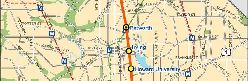
Exhibit 10: Boarding and Alighting Activity, Route 70-71 (Southbound)
Total Weekday Boardings+ Rank Boardings+
On Street Cross Street Boardings Alightings Alightings Boardings Alightings Alightings
SILVER SPRING STA. MC BUS BAY J ( TP) 1,953 - 1,953 1 82 1
GEORGIA AVE MC BONIFANT ST 406 13 419 5 71 10
GEORGIA AVE MC SILVER SPRING AV E 80 42 122 39 60 54
GEORGIA AVE MC 13TH ST 56 75 130 46 44 48
GEORGIA AVE MC EASTERN AVE ( TP) 122 137 259 27 17 24
GEORGIA AVE NW JUNIPER ST X 133 73 206 23 45 31
GEORGIA AVE NW HEMLOCK ST X 76 39 115 40 61 55
GEORGIA AVE NW GERA NIUM ST 119 80 199 28 41 34
GEORGIA AVE NW DAHLIA ST 116 167 282 30 12 19
GEORGIA AVE NW BUTTERNUT ST. 125 80 205 25 40 32
GEORGIA AVE NW VAN BUREN ST 205 123 328 13 22 16
GEORGIA AVE NW PINEY BRANCH RD 204 118 322 15 23 17
GEORGIA AVE NW RITTENHOUSE ST 279 126 405 8 21 11
GEORGIA AVE NW QUACKENBOS ST 102 63 165 34 51 42
GEORGIA AVE NW ROCK CREEK FORD RD 418 147 564 3 15 7
GEORGIA AVE NW MA DISON ST 112 77 188 31 43 36
GEORGIA AVE NW KENNEDY ST ( TP) 407 309 716 4 5 6
GEORGIA AVE NW INGRAHA M ST 209 68 277 11 47 21
GEORGIA AVE NW GALLATIN ST 144 43 187 22 59 37
GEORGIA AVE NW FARRAGUT ST 128 57 185 24 56 38
GEORGIA AVE NW DECA TUR ST 206 95 300 12 33 18
GEORGIA AVE NW BUCHA NAN ST 70 58 128 41 55 49
GEORGIA AVE NW WEBSTER ST 123 95 217 26 33 28
GEORGIA AVE NW KANSAS AVE 146 102 248 21 29 26
GEORGIA AVE NW SHEPHERD ST 81 65 146 38 49 46
GEORGIA AVE NW RANDOLPH ST 38 86 124 49 37 53
GEORGIA AVE NW PETWORTH METRO 676 795 1,471 2 3 2
GEORGIA AVE NW N. HA MPSHIRE AV E (TP) 119 58 177 29 54 41
GEORGIA AVE NW NEWTON PL 82 112 194 37 25 35
GEORGIA AVE NW PA RK RD 191 153 344 18 13 14
GEORGIA AVE NW LAMONT ST 234 98 332 10 31 15
GEORGIA AVE NW IRV ING ST 205 228 433 14 7 9
GEORGIA AVE NW COLUMBIA RD 265 136 401 9 19 12
GEORGIA AVE NW GRESHA M PL 154 111 265 20 26 23
GEORGIA AVE NW EUCLID ST 91 148 238 35 14 27
GEORGIA AVE NW BANNEKER REC CTR 8 18 26 60 66 68
GEORGIA AVE NW BARRY PL 64 137 201 45 17 33
GEORGIA AVE NW W ST X 56 72 127 46 46 50
GEORGIA AVE NW V ST 37 144 181 50 16 39
GEORGIA AVE NW FLORIDA AVE (TP) 195 1,045 1,240 17 2 4
7TH ST NW T ST 291 93 383 7 35 13
7TH ST NW S ST 46 79 124 48 42 52
7TH ST NW R ST 157 109 265 19 28 22
7TH ST NW Q ST 66 111 177 43 26 40
7TH ST NW P ST 204 272 475 16 6 8
7TH ST NW N ST 104 61 164 33 53 43
7TH ST NW M ST 68 96 164 42 32 43
7TH ST NW L ST 13 34 47 58 62 64
7TH ST NW MT V ERNON PL 5 54 59 63 57 62
7TH ST NW I ST 7 81 88 61 39 58
7TH ST NW H ST ( TP) 296 1,164 1,460 6 1 3
7TH ST NW G ST 35 114 148 51 24 45
7TH ST NW E ST 66 190 256 43 10 25
7TH ST NW PENNSYLVANIA AVE (TP) 108 668 776 32 4 5
7TH ST NW CONSTITUTION AV E 25 62 87 53 52 59
9TH ST NW CONSTITUTION AV E(TP-70/) 3 6 9 67 76 77
7TH ST SW INDEPENDENCE AV E 25 101 125 55 30 51
7TH ST SW C ST 10 135 145 59 20 47
D ST SW 7TH ST (TP-70) 1 52 53 71 58 63
7TH ST SW E ST X ( TP) 89 190 279 36 10 20
7TH ST SW G ST X - 16 16 73 68 70
7TH ST SW I ST X 16 196 212 56 9 30
I ST SW 7TH ST 2 17 19 69 67 69
7TH ST SW MA INE AVE - 82 82 73 38 60
MA INE AVE SW 9TH ST ( TP) 2 4 6 69 78 79
6TH ST SW K ST X 0 15 15 73 70 72
6TH ST SW ARENA STAGE 3 10 13 67 74 74
M ST SW 6TH ST 5 26 31 63 64 66
M ST SW BET 3RD & 4TH STS 29.5 66.5 96 52 48 57
DELAWARE AV E SW M ST 25 88 113 53 36 56
DELAWARE AV E SW #1301-1311 0 30.5 31 73 63 67
DELAWARE AV E SW CANAL ST 0 16 16 73 68 70
CANAL ST SW P ST (AM ONLY) 1 4 5 71 78 80
O ST SW FIRST ST 4.5 10.5 15 65 73 72
HALF ST SW O ST ( TP) 6 207 213 62 8 29
P ST SW FIRST ST ( PM ONLY) 14 20 34 57 65 65
2ND ST SW Q ST X 4.5 5 10 65 77 76
2ND ST SW S ST X 0 1 1 73 81 82
2ND ST SW T ST X 0 3 3 73 80 81
V ST SW BET 2ND & 1ST STS(TP-71) 0 64.5 65 73 49 61
WATER ST SW BET HALF & T STS (A M) 0 8 8 73 75 78
WATER ST SW BET T & S STS ( TP-71 A M) 0 11 11 73 72 75
TOTAL SOUTHBOUND STOP A CTIVITY 10,153 10,153 20,305
TOTAL SOUTHBOUND ACTIV ITY, EASTERN AVE TO ARCHIV ES 7,274 8,440 15,713
Source: WMATA Ridecheck 2005
8Exhibit 11: Peak Hour, Peak Direction Bus Load Levels, Route 70-71
Source: WMAT A Ride check, Collected 2005
9Exhibit 12: Weekday Transit Travel Speed, Route 70-71
Source: WMAT A Passenger & Time Report, 2004- 2005
10Transit Travel Time and Speed between Time Points
Exhibit 14: Travel Time between Timepoints and Travel Speed by Time of Day (Southbound)
The WMATA Passenger and Time Report from 2004-2005 was used to calculate transit travel time and
speed between time points. The Passenger and Time Report lists the scheduled and actual time of arrival Travel Time GA/Eastern- GA/Kennedy- Petworth- GA/Irving- GA/FL- 7th/H- Total
at time points along the route for every trip in the day in each direction. These were aggregated by time (Min) GA/Kennedy Petworth GA/Irving GA/FL 7th/H 7th/PA Trip
period to show the change in travel speed by direction by time of day; and to show where delays were Early AM 9 6 4 4 8 3 34
resulting in very slow travel times between certain points. AM Peak 11 8 4 6 10 4 43
Midday 13 8 5 7 12 4 49
PM Peak 12 9 5 6 9 4 45
In addition, delay was also measured by comparing the scheduled and actual arrival times at each time Evening 9 7 4 6 8 2 36
point by direction and by time of day. Because there was significant variation in the amount of delay – After 12 8 5 3 5 6 2 29
th
from early arrival to 20+ minutes of day – the median delay at time points was measured. Travel GA/Eastern- GA/Kennedy- Petworth- GA/Irving- GA/FL- 7 /H- Total
Speed (mph) GA/Kennedy Petworth GA/Irving GA/FL 7th/H 7th/PA Trip
The results of this analysis are shown in Exhibit 13 (Northbound trips) and Exhibit 14 (Southbound). Early AM 13.0 13.9 7.5 13.4 8.5 8.8 12.7
AM Peak 10.6 10.4 7.5 8.9 6.8 6.6 10.0
Midday 9.0 10.4 6.0 7.6 5.7 6.6 8.8
PM Peak 9.8 9.3 6.0 8.9 7.5 6.6 9.6
Exhibit 13: Travel Time between Timepoints and Travel Speed by Time of Day (Northbound) Evening 13.0 11.9 7.5 8.9 8.5 13.2 12.0
After 12 13.8 16.7 8.7 10.7 10.5 11.0 14.8
Travel Time 7th/PA- 7th/H- GA/FL- GA/Irving- Petworth- GA/Kennedy- Total Median GA/ GA/
GA/Eastern GA/Irving GA/FL 7th/H 7th/PA
(Min) 7th/H GA/FL GA/Irving Petworth GA/Kennedy GA/Blair Trip Delay (Min) Kennedy Petworth
Early AM 2 6 3 3 6 10 30 Early AM 2.0 1.0 1.0 1.0 2.0 2.0 2.0
AM Peak 4 10 7 4 8 11 44 AM Peak 1.0 2.5 2.5 2.5 2.0 3.0 4.0
Midday 5 11 8 6 11 14 55 Midday 2.0 3.0 3.0 4.0 4.0 6.0 7.0
PM Peak 5 10 7 5 10 13 50 PM Peak 1.0 2.0 2.0 3.0 2.0 3.0 3.0
Evening 3 8 6 4 8 10 39 Evening 2.0 3.0 4.0 4.0 5.0 6.0 6.0
After 12 3 6 5 4 7 9 34 After 12 5.0 5.5 5.5 6.5 6.5 7.0 8.0
Travel 7th/PA- 7th/H- GA/FL- GA/Irving- Petworth- GA/Kennedy- Total
Speed (mph) 7th/H GA/FL GA/Irving Petworth GA/Kennedy GA/Blair Trip
Early AM 11.0 11.3 15.6 10.0 12.9 11.7 12.6
AM Peak 6.6 6.8 7.6 7.5 9.8 10.2 8.6 Based on the results shown in Exhibits 13 and 14:
Midday 5.3 6.2 6.7 5.0 7.6 8.1 6.9
PM Peak 5.3 6.8 7.6 6.0 8.3 9.0 7.6
Although there is consistent delay across all time points and time of day, the delay is on the whole
Evening 8.8 8.5 8.9 7.5 10.4 11.7 9.7 fairly minor
After 12 8.8 11.3 10.7 7.5 11.9 13.0 11.1 The slowest travel times are during the midday period in both directions, and travel speed does not
Median
7th/PA 7th/H GA/FL GA/Irving Petworth GA/Kennedy GA/Blair
appear to follow peak period travel patterns; this is representative of a roadway that carries lots of
Delay (Min) local trips and not a lot of commuting traffic
Early AM 1.0 0.5 1.0 1.0 0.5 0.5 2.5 The slowest travel is between the timepoints at Georgia and Irving and Petworth Metro, while the
AM Peak 1.0 1.0 2.0 2.0 2.0 2.0 4.0
Midday 2.0 2.5 2.0 2.5 2.0 4.0 5.5 second slowest times were in the downtown area
PM Peak 2.0 3.0 4.0 5.0 5.0 6.0 4.0
Evening 2.0 2.0 2.0 3.0 4.0 4.0 4.0
After 12 3.0 4.0 4.0 4.0 4.0 4.0 6.0
11Section 2: Metro EXTRA Service Plan for Georgia Ave-7th Street NW Corridor Vehicles
The following section describes the Rapid Bus (Metro EXTRA) service concept for the Georgia Avenue- The proposed service would use low floor 40’ buses, comparable to recent new vehicles purchased for
7th Street NW Corridor and provides preliminary operating and capital costs associated with the plan. Metrobus service. Vehicles would be some type of alternative fuel, either CNG or diesel-hybrid. Buses
would be “branded” – specially painted or otherwise marked to distinguish them from Metrobuses already
Service Concept operating in the corridor.
The Rapid Bus Implementation Plan addresses the challenges faced by transit in the corridor through the The number of buses required for the service is a function of the service frequency and travel speed of the
recommendation of a new bus route, referred to in this document as the Georgia Avenue Rapid route. The new service. In the peak period only service plan, the number of vehicles is driven by the travel speeds in
service concept for the Georgia Avenue Rapid route is as follows: the p.m. peak period (speeds are higher in the a.m. peak). In service between Archives and Eastern
Avenue, a round trip requires 80 minutes in the p.m. peak period. Given 10-minute headways and a 10%
Limited stop bus service between Archives and Silver Spring recovery period, this would require 9 vehicles. Between Archives and Silver Spring, 89 minutes are
required, which would call for 10 vehicles. Capital costs assume a 20% spare ratio (2 buses), which is
High frequencies of service
consistent with existing WMATA Metrobus spare ratios.
Service only during peak travel times during weekdays
o Peak only service for immediate implementation For the all-day service plan, the vehicles required are driven by the midday period travel times, when
o All-day service for eventual service expansion
speeds are slowest. Round trip travel time between Archives and Eastern Avenue is 89 minutes in the
Improved passenger facilities midday period. Given 10-minute headways and a 10% recovery period, this would require 10 vehicles.
Running way improvements to improve travel speed and reliability Between Archives and Silver Spring, 98 minutes are required, or 12 vehicles. The capital costs also
Extensive branding for corridor service assume a 20% spare ratio (2 buses), which is consistent with existing WMATA Metrobus spare ratios.
No reduction in underlying (existing) local bus service in the corridor
The service plan for the recommended service is shown in Exhibit 15.
Exhibit 15: Georgia Avenue-7th Street Corridor Metro EXTRA Service Plan Metro EXTRA
Rapid Bus
Service Type Limited stop “Rapid Bus” service called “Metro EXTRA” service would
use distinctive
Corridor Length 7.4 miles (Archives to Silver Spring) colors to make it
easy to identify
15 (northbound)
Number of Stops vehicles.
14 (southbound)
Weekday Service Plan Peak Only All-Day Service
AM Peak (5:30 a.m. – 9:30 a.m.) 10 minute headway 10 minute headway
Midday (9:30 a.m. – 3:00 p.m.) No service 10 minute headway
PM Peak (3:00 p.m. – 7:00 p.m.) 10 minute headway 10 minute headway
Evening (7:00 p.m. – 10:00 p.m.) No service 15 minute headway
Weekend Service Plan No Weekend Service
The proposed route is shown in Exhibit 16. Although the route would run at a 10-minute headway
schedule during peak hours, printed schedules would not be necessary, at least in the beginning of service.
Instead, drivers would start at the route ends every 10 minutes, and would be encouraged to make the best
time possible to the end of the routes.
12Exhibit 16: Georgia Avenue - 7th Street Proposed Metro EXTRA Service
13Stop Locations leaving their alighting locations immediately to walk to their final destinations, as opposed to waiting for
another bus, the full amenity package is not necessary at major alighting locations, just the major boarding
Stops were spaced similarly to light rail stops, or to Metrorail stops in the central part of the District: about locations.
one stop every ½ mile. Over the 7.4 mile corridor, this works out to about 28 stops (14 in each direction).
Once the original set of stops was placed evenly spaced over the corridor, stops were shifted based on the In some cases, the existing local bus stops would be relocated to share shelters and stops with the proposed
following methodology: Metro EXTRA stops. In other cases, the stops could be separate, and located across the street or down the
block from one another.
Wherever feasible, stops should be located adjacent to Metrorail entrances:
Archives In the downtown area, stops already exist where there is sufficient sidewalk space to accommodate
Gallery Place shelters, and in these locations, the Metro EXTRA Service would share the existing shelters.
Shaw-Howard U
Petworth Parking displacement is a major concern when locating stops. On a street with curbside parking, any new
Silver Spring stop will displace 4-5 parking spaces. In some cases, stops can be located in areas that do not currently
allow parking. In other cases, if the existing local bus stop is combined with a new Metro EXTRA stop,
In addition, stops should be located at major Metrobus transfer locations and Downtown Circulator the old bus zone can be replaced with curbside parking to replace that lost at the new Metro EXTRA stop.
transfer locations:
Mount Vernon Square Corridor-wide, as many as 30 spaces in the northbound direction and 40 spaces in the southbound
direction could be affected by the service plan for the Georgia Avenue-7th Street Metro EXTRA service.
Florida Avenue
As many as 40 new spots could be created to offset the 70-space reduction if the existing nearside bus
Irving
stops were relocated to share with the new farside Metro EXTRA stops.
Kennedy
Walter Reed Exhibit 17 shows a “strip map” of Metro EXTRA stops for the route. Strip maps would be located on
Shepherd Park vehicles and at all Metro EXTRA stops, and resemble the maps used on rail transit systems. The maps
could be distributed as part of a marketing effort for the new service.
Stops should be located at existing major boarding and alighting locations:
Decatur Exhibit 17: Georgia Avenue-7th Street NW Corridor Metro EXTRA “Strip Map”
Brightwood
Piney Branch
Finally, even where none of the above conditions exist, stops should be located at major landmarks or
potential trip attractors:
Howard University
Passenger amenities vary by stop. A full amenity package would include the following elements:
A bus “flag” (a distinct sign for the Metro EXTRA service)
A passenger shelter, which would include a concrete pad, bench, map, and schedule
An “ITS” feature: a screen showing real-time bus arrival information.
New stops are assumed to be obtained via the “Ad Shell” program, and no costs are assumed for these
stops. The Ad Shell stops would include ITS real time arrival signs that work with GPS transmitters
already present on most Metrobuses.
Generally, stops can be categorized as either major boarding locations or alighting locations. For example,
the Piney Branch stop is a major boarding location in the southbound direction in the A.M. and midday Detailed information about stop location and passenger amenities at each proposed stop is shown in
time period. The northbound stop would be a major alighting location in the midday, P.M. peak, and Exhibit 18 and Exhibit 19.
evening time periods, but is not a major boarding location at any time. Because passengers are typically
14Exhibit 18: Georgia Avenue-7 th Street Corridor, Proposed Metro EXTRA Stops
Existing Weekday
Map Index Station Name Station Location Curb Type Passenger Infrastructure Notes
Boardings (Route 70-71)
Northbound
Eastside of 7th Street NW between Entire block is no parking; short Existing passenger shelter at
7th / Penn-643 Existing Rte 70-71 and
N01 Archives Indiana Ave & Pennsylvania Ave block is primarily taken up by bus stop; add flag and ITS
7th / E-161 Downtown Circulator stop
(Mid-Block) stop and right-turning traffic elements only
Short Term:
Eastside of 7th Street just south of H th
Covered area at Metro
Street (Nearside) 7 / G-188 Stop at existing curbside bus zone; entrance serves as passenger Existing Rte 70-71 and
N02 Gallery Place
7th / H-1,320 Proposed Bulbout in long term shelter at stop; add flag and Circulator stop
Long Term: ITS elements only
Add Bulbout at this location
Short Term:
Mount Vernon Square Eastside of 7th Street NW just south of Stop at existing curbside bus zone
L Street (Nearside) 7th / Mass-129 No shelter, flag and ITS Share with existing Circulator
N03 (Washington
7th / M-190 element stop
Convention Center) Long Term:
Add Bulbout
Add Bulbout at this location
Eastside of 7th Street NW on the Existing passenger shelter at
7th / Rhode Island-253 Share with existing Rte 70-71
N04 Shaw southside of Rhode Island Avenue Stop at existing curbside bus zone stop; add flag and ITS
7th / S-341 stop
(Nearside) elements only
Need to coordinate with
Howard University Eastside of Georgia Avenue NW just 7th / Florida-963 Add No Parking (Bus) Zone at Howard University Hospital.
N05 Add new shelter, flag, ITS
Medical Center north of Florida Avenue (Farside) GA / V-227 curb New shelter encroaches on
parking lot.
Short Term:
Eastside of Georgia Avenue NW just Stop at existing curbside bus zone Add new shelter, flag, ITS;
GA / Barry-182
south of Howard Place (Nearside) work with Howard University Share with existing Rte 70-71
N06 Howard University GA / Howard-42
on shelter placement and stop
Long Term: GA / Euclid-179
Add Bulbout design
Add Bulbout at this location
Short Term:
No shelter, add flag and ITS Share with existing Rte 70-71
Eastside of Georgia Avenue NW just Stop at existing curbside bus zone
elements only stop
south of Irving Street (Nearside)
N07 Irving GA / Irving-488 On-street parking lane will
remain. Entire block will be
Long Term: Add Bulbout. Add No Parking
Add new shelter bus zone, keep separate from
Add Bulbout at this location (Bus) Zone at curb for entire block
existing 70-71 stop at Irving
(nearside)
15Existing Weekday
Map Index Station Name Station Location Curb Type Passenger Infrastructure Notes
Boardings (Route 70-71)
Eastside of Georgia Avenue NW just GA / New Hampshire- Replace existing shelter with
N08 Petworth north of New Hampshire Avenue 1,147 Stop at existing curbside bus zone new shelter; flag and ITS Use existing transfer facility
(Farside) GA / Randolph-136 element
Eastside of Georgia Avenue NW just GA / Decatur-81 Add new shelter, flag and ITS Existing 70-71 stop is nearside
N09 Decatur Add no parking (bus) zone at curb
north of Decatur Street (Farside) GA / Emerson-43 element at same intersection
Short Term:
No shelter, add flag and ITS
Eastside of Georgia Avenue NW just Stop at existing curbside bus zone Share with existing 70-71 stop
elements
south of Kennedy Street (Nearside)
N10 Kennedy GA / Kennedy-350
Long Term: Add new shelter and move flag
Existing 70-71 stop is nearside
Eastside of Georgia Avenue NW just Add Bulbout and ITS elements from
at same intersection
north of Kennedy Street (Farside) nearside stop
Short Term:
Add new shelter at stop; add
Eastside of Georgia Avenue NW just Share with existing 70-71stop
flag and ITS elements only
south of Missouri Ave (Nearside)
N11 Brightwood GA / Missouri-37 Stop at existing curbside bus zone
Long Term:
Add new shelter and move flag
Possible move to eastside of Georgia Possible move; parking spaces
and ITS elements from short
Avenue NW just north of Peabody St need to be removed
term stop
(Farside)
Short Term:
Existing shelter, add flag and
Eastside of Georgia Avenue NW just Share with existing 70-71 stop
ITS elements
south of Tuckerman Road (Nearside)
GA / Tuckerman-127
N12 Piney Branch Stop at existing curbside bus zone
GA / Underwood-90
Long Term: Add new shelter and move flag
Eastside of Georgia Avenue NW just and ITS elements from Share with existing 70-71 stop
north of Underwood Street (Farside) nearside stop
Eastside of Georgia Avenue NW just No shelter, add flag and ITS
N13 Walter Reed GA / Dahlia-119 Stop at existing curbside bus zone Share with existing 70-71 stop
south of Dahlia Street (Nearside) elements
Eastside of Georgia Avenue just south GA / Juniper-104 Add No Parking (Bus) Zone at No shelter, flag and ITS
N14 Shepherd Park No existing stop at this location
of Blair Road (Nearside) GA / Blair-51 curb element
-- Silver Spring Silver Spring Metro Station Share existing bus bay and stop Add flag and ITS element Destination point
16Existing Weekday
Map Index Station Name Station Location Curb Type Passenger Infrastructure Notes
Boardings (Route 70-71)
Southbound
-- Silver Spring Silver Spring Metro Station Silver Spring- 1953 Share existing bus bay and stop Add flag Origin point
Westside of Georgia Avenue NW just Add No Parking (Bus) Zone at Add new shelter, flag and ITS
S01 Shepherd Park GA / Eastern-122
south of Eastern Ave (Farside) curb element
Westside of Georgia Avenue NW just No existing shelter, add new
S02 Walter Reed GA / Dahlia-116 Stop at existing curbside bus zone Share with existing 70-71 stop
north of Dahlia Street (Nearside) shelter, flag and ITS element
Short Term:
No existing shelter, add flag
Westside of Georgia Avenue NW just
and ITS element
north of Piney Branch Road(Nearside)
S03 Piney Branch GA / Piney Branch-204 Stop at existing curbside bus zone Share with existing 70-71 stop
Long Term:
Westside of Georgia Avenue NW just Add very narrow new shelter
north of Piney Branch Rd (Nearside)
Short Term:
Westside of Georgia Avenue NW just
Stop at existing curbside bus zone Add flag and ITS element Share with existing 70-71 stop
north of Rock Creek Ford Road
(Nearside) GA / Rock Creek Ford-
S04 Brightwood
418
Long Term: Add new shelter and move flag
Add No Parking (Bus) Zone at Existing 70-71 stop is nearside
Westside of Georgia Avenue NW just and ITS elements from Rock
curb at same intersection
south of Quackenbos St (Farside) Creek Ford Rd stop
Short Term:
No Shelter, add flag and ITS
Westside of Georgia Avenue NW just Stop at existing curbside bus zone
element
S05 Kennedy north of Kennedy St (Nearside) GA / Kennedy-407 Share with existing 70-71 stop
Long Term:
Add Bulbout Add new shelter
Add bulbout at this location
Existing passenger shelter at
Westside of Georgia Avenue NW just
S06 Decatur GA / Decatur-206 Stop at existing curbside bus zone stop; add flag and ITS Share with existing 70-71 stop
north of Decatur Street (Nearside)
elements only
Short Term:
Add No Parking (Bus) Zone at No existing shelter, add flag Existing 70-71 stop is farside at
Westside of Georgia Avenue NW just
curb and ITS element same intersection
north of Quincy Street (Nearside)
Petworth Metro-676
S07 Petworth Long Term:
GA / New Hampshire-795
Westside of Georgia Ave NW just Use existing transfer center
Share with existing transfer
north of New Hampshire Avenue Existing sawtooth bays at Metro and mo ve flag and ITS element
center at Petworth Metro
(Whole Block) from short term location
17Existing Weekday
Map Index Station Name Station Location Curb Type Passenger Infrastructure Notes
Boardings (Route 70-71)
Short Term: Existing passenger shelter at
Westside of Georgia Avenue NW just Stop at existing curbside bus zone stop; add flag and ITS Share with existing 70-71 stop
north of Columbia Road (Nearside) GA / Irving-205 elements only
S08 Irving-Columbia
Long Term: GA / Columbia-265 Add new shelter and move flag
No Parking (Bus) Zone entire Existing 70-71 stop at end of
Westside of Georgia Avenue NW just and ITS elements from end of
block between Irving & Columbia block (has shelter)
south of Irving St (Farside) block
Short Term:
Westside of Georgia Avenue NW No existing shelter, add flag
Stop at existing curbside bus zone Share with existing 70-71 stop
between Euclid St and Howard Place and ITS element
(Mid Block) GA / Euclid-91
S09 Howard University
GA / Howard-8
Long Term: Add new shelter, flag and ITS Existing 70-71 stop is
Westside of Georgia Avenue NW just Add Bulbout element; work with university midblock between Euclid St
north of Howard Place (nearside) on design, placement and Howard Place
Existing passenger shelter at
Howard University Westside of Georgia Avenue NW just GA / Florida-195
S10 Stop at existing curbside bus zone stop; add flag and ITS Share with existing 70-71 stop
Medical Center north of T Street (Nearside) GA / T-291
elements only
Existing passenger shelter at
Westside of 7th Street NW just north 7th / R-157
S11 Shaw Stop at existing curbside bus zone stop; add flag and ITS Share with existing 70-71 stop
of R Street (Nearside) 7th / Q-66
elements only
Mount Vernon Square
Westside of 9th Street NW just north No existing shelter; add flag Share with Downtown
S12 (Washington Stop at existing curbside bus zone
of Massachusetts Ave (Nearside) only Circulator stop
Convention Center)
Westside of 9th Street NW just north Existing passenger shelter at Share with Downtown
S13 Gallery Place Stop at existing curbside bus zone
of H Street (Nearside) stop; add flag only Circulator stop
18Exhibit 19 shows the features and potential impacts at each stop location. The table includes the type of shelter provided, passenger
information, parking implication and needed infrastructure improvements at each stop.
Exhibit 19: Georgia Avenue - 7th Street Proposed Metro EXTRA Stop Requirements for Short Term
Request an Additional "Narrow" Shelter from
Request DDOT To Expand Sidewalk to Curb
Existing Shelter Replaced By Clear Channel
Flag/Schedule/Map on Existing Shelter Until
Next Bus Screen in Clear Channel Shelter
Request an Additional Shelter from Clear
Request DDOT To Add Concrete Pad for
Flag/Schedule/Map on Temp Pole Until
Remove Parking Spaces at Stop
Flag/Schedule/Map on Shelter
Flag/Schedule/Map on Pole
New Shelter is Installed
No Shelter Provided
Shelter is Installed
Clear Channel
Edge at Stop
Channel
Shelter
Location
Stop
Eastside of 7th Street between Indiana Avenue and
N01
Pennsylvania Avenue
Eastside of 7th Street just south of H Street at Gallery Place
N02
Metro Entrance
S13 Westside of 9th Street just north of H Street
N03 Eastside of 7th Street just south of L Street
Westside of 9th Street just north of Massachusetts Ave at Mt
S12
Vernon Square
Eastside of Georgia Avenue just south of Rhode Island
N04
Avenue near Shaw/Howard Metro Station
Westside of 7th Street just north of R Street at Shaw/Howard
S11
Metro Station
Eastside of Georgia Avenue just north of Florida Avenue
N05
(Adjacent to Howard University Hospital Parking Lot)
S10 Westside of 7th Street just north of T street
N06 Eastside of Georgia Avenue just south of Howard Place
Westside of Georgia Avenue between Euclid Street and
S09
Howard Place
N07 Eastside of Georgia Avenue just south of Irving Street
S08 Westside of Georgia Avenue just north of Columbia Road
Eastside of Georgia Avenue just north of New Hampshire
N08
Avenue at Petworth Metro Station
S07 Westside of Georgia Avenue just north of Quincy Street
N09 Eastside of Georgia Avenue just north of Decatur Street
S06 Westside of Georgia Avenue just north of Decatur Street
N10 Eastside of Georgia Avenue just south of Kennedy Street
S05 Westside of Georgia Avenue just north of Kennedy Street
N11 Eastside of Georgia Avenue just south of Missouri Avenue
Westside of Georgia Avenue just north of Rock Creek Ford
S04
Road
N12 Eastside of Georgia Avenue just south of Tuckerman Street
S03 Westside of Georgia Avenue just north of Piney Branch Road
Eastside of Georgia Avenue just south of Dahlia Street (at
N13
Walter Reed Entrance)
Westside of Georgia Avenue just north of Dahlia Street (at
S02
Walter Reed Entrance)
Eastside of Georgia Avenue just south of Blair Road (Eastern
N14
Avenue)
S01 Westside of Georgia Avenue just south of Eastern Avenue
TOTAL 10 3 2 12 15 12 5 10 15 2 1 3
19Where stopped buses would not cause substantial intersection congestion problems by blocking
traffic
Metro EXTRA Rapid Bus For the purposes of this corridor, curb extensions were recommended at the following locations:
stops would include ITS “Real
Time” bus arrival information 7th Street / H Street NW (northbound direction, near side of intersection)
7th Street / L Street NW (northbound direction, near side of intersection)
Georgia Avenue / Howard Place NW (northbound direction, far side of intersection)
Georgia Avenue / Howard Place NW (southbound direction, far side of intersection)
Georgia Avenue / Irving Street (both directions, south side of intersection)
Metro EXTRA Rapid Georgia Avenue / Kennedy Street (both directions, south side of intersection)
Bus stops would
feature distinct stops Bus Zones
signs, which could be
added to existing stops In order to preserve curb space so buses can stop flush with the curbs, bus zones do not allow parking at
bus stops. The length of a bus zone varies, but must be long enough to allow a bus to stop completely out
of traffic, and to allow a bus to pull in and / or out depending on where the stop is located. Bus zones
located on the far side of intersections can be slightly shorter because buses can use the width of the
Running Way Improvements intersection to pull into the curb lane.
Running way improvements provide ways to increase vehicle travel speed and reliability. For the Where there is no bulbout, bus zones are necessary because parked cars blocking stops would prevent
purposes of this project, the need to complete construction in a short time and to minimize disruption of passengers with mobility-related disabilities from reaching buses.
existing traffic flow and parking meant that only a limited array of potential running way improvements
was feasible. The Service will start immediately with very minimum short-term improvements and In some cases, the recommended Rapid service can use existing zones and share a stop with the existing
eventually all the improvements planned for the service are completed in long-term. Running way local service in the corridor. In other cases, new bus zones are recommended.
improvements are shown in the Appendix A: Georgia Avenue-7 th Street Corridor Proposed Rapid Bus
Service. These improvements include: Signal Priority
Curb Bulbouts(long-term) The Georgia Avenue-7 th Street Metro EXTRA Rapid service is designed to take advantage of the on-going
Georgia Avenue signal priority project. This project should increase travel speeds and reliability by
Curb Bulbouts – curb bulbouts extend the curb to the edge of the lane in which buses are operating. In providing transit vehicles with extended green signals (either starting the green cycle early or extending a
doing so, the provide advantages for transit operations: cycle). The system is based on conditional priority, which means signals can be set to extend greens only
when buses are running behind schedule.
Passengers do not have to squeeze between parked cars to reach the bus
Buses do not have to pull into and out of traffic The signal priority system requires special controllers and software to be located within the intersection
There is a reduced accident risk from buses pulling unexpectedly away from curbs into traffic, or signal control cases. Controllers are already proposed for all signalized intersections between Rhode
from cars trying to squeeze past buses that are only partially pulled over Island Avenue and Eastern Avenue except for Rhode Island Avenue and Kansas Avenue. The Georgia
Avenue / 7th Street Metro EXTRA Rapid plan calls for the signal priority system to be extended
Curb extensions also preserve sidewalk space. southward to N Street NW.
The negative impacts of curb extensions are that stopped buses interrupt traffic flow and they potentially
block a right turn lane for traffic. Therefore, curb extensions are only recommended in the following
cases:
Where the curb lanes are used full time for parking
20Travel Speed and Travel Time Ridership
Travel speed estimates were based on existing Metrobus travel speeds. Travel speeds were calculated Ridership projections were made for the full-day service plan. As a conservative ridership estimate,
based on the WMATA Metrobus Passenger and Time Report (collected November 2004-April 2005) for ridership projections from the Regional Bus Study (2003) were used. The Regional Bus Study
Route 70-71. The existing speeds were then adjusted to take into account the impact of the new stop recommended a Rapid Bus route along Georgia Avenue / 7 th Street that was similar to that proposed in this
spacing and of running way improvements. study, albeit with a lower level of service. Forecast ridership in that study was 2,007 daily riders on the
Rapid Bus service, partially offset by a loss of 134 daily riders on the local service.
A peer review of Rapid Bus-type service in other cities was conducted to determine the relationship
between travel speed of local service and of Rapid Bus service in the same corridors. The review revealed A more aggressive methodology proposed an overall ridership increase in the corridor of 8% (this increase
a wide range of impacts on travel speed. In Los Angeles, the Metro Rapid service showed an increase of was based on the Regional Bus Plan regional ridership increase due to implementation of Rapid Bus
12% to 29% versus local service in the same corridors. In Oakland, AC Transit’s San Pablo Rapid route service). Increasing the corridor ridership by 8% increases boardings to 23,760 per day. These boardings
showed a speed increase of 13%. In Chicago, the “X” Crosstown Express routes showed speed increases were then re-allocated based on the proportion of corridor revenue hours provided by local service (Route
of 15% to 40%. In order to be conservative, the speed increase for the proposed Georgia Avenue / 7th 70-71) and by Rapid Service. Thus, because Rapid Bus service accounts for 34% of revenue hours in the
Street service was set at 15% to account for the impact of reduced stops, reduced boarding times, and the corridor on a weekday, 34% of 23,760 equals 8,000 daily riders. Under this methodology, ridership on
impact of the signal priority system and other running way improvements. local service would decrease to 15,750 daily riders.
This travel speed estimate was verified by calculating the travel time for the route based on the maximum If service is operating only during the peak periods, ridership would be lower than on the all-day service.
possible speed, with delay added for traffic congestion, signal delay, dwell times, and vehicle acceleration According to April 2005 Ridecheck data, 51 percent of all boardings take place in the a.m. and p.m. peak
and deceleration characteristics. The travel speeds in the calculation were consistent with existing speeds periods for Route 70-71. Using a 51 percent factor for the all-day ridership estimates yields an estimate
adjusted by 15%, as described above. peak period ridership of 1,024 (conservative method) or 4,080 (aggressive method).
Exhibit 20 shows the estimated travel times for the Georgia Avenue-7th Street Metro EXTRA Rapid Bus Operating Costs
route.
Operating costs were based on estimated annual revenue hours of service. Revenue hours were generated
Exhibit 20: Estimated Rapid Bus Speed and Travel Time based on the service plan shown in Exhibit 15 and the travel speeds shown in Exhibit 20. These data
were used to estimate daily revenue hours and revenue miles of service. Given that service is assumed
only on non-holiday weekdays, daily data was annualized based on the assumption of 255 annual
Speed and Travel Time Northbound Southbound weekdays.
Average Speed
AM Peak 9.9 mph 11.5 mph Operating and maintenance (O&M) costs were determined by multiplying the annual revenue hours of
Midday 7.9 mph 10.1 mph service by the WMATA incremental cost for adding a new revenue hour of service. The incremental cost
PM Peak 8.7 mph 11.0 mph was derived from a WMATA incremental cost for a new platform hour of service. Platform hours were
Evening 11.2 mph 13.8 mph converted to revenue hours based on the ratio of platform to revenue hours for all local Metrobus routes
during summer, 2005.
1-Way Travel Time – to Eastern Avenue
AM Peak 39 minutes 35 minutes The incremental cost includes all costs related directly to operating service, but does not include some
Midday 49 minutes 40 minutes fixed costs that do not change based on additional hours of service being added to the system. The
PM Peak 44 minutes 36 minutes incremental cost per new revenue hour of service is $90.86.
Evening 35 minutes 29 minutes
Exhibit 21 shows the operating statistics for the Georgia Avenue-7 th Street route.
1-Way Travel Time – to Silver Spring
AM Peak 44 minutes 38 minutes
Midday 55 minutes 43 minutes
PM Peak 50 minutes 39 minutes
Evening 39 minutes 32 minutes
21A more aggressive or extensive marketing and branding strategy
Exhibit 21: Operating Statistics for Georgia Avenue-7 th Street Metro EXTRA Rapid Bus Service
Exhibit 22 shows the capital costs associated with the Georgia Avenue-7th Street Metro EXTRA Rapid
bus corridor.
Statistic Archives-Silver Spring
Peak Period Only Service
Daily Revenue Miles 695
Annual Revenue Miles 177,000
Daily Revenue Hours 68
Annual Revenue Hours 17,400
Cost / Revenue Hour $90.86
Annual O&M Cost $1,600,000
All-Day Service
Daily Revenue Miles 1,300
Annual Revenue Miles 343,000
Daily Revenue Hours 136
Annual Revenue Hours 35,000
Cost / Revenue Hour $90.86
Annual O&M Cost $3,200,000
Capital Costs
Capital costs include running way improvements (curb bulbouts, signal priority), new bus stops and ITS
features, and new buses. The costs included in this section include a full implementation of the
recommended service plan. However, while some capital components are necessary for implementation of
the service, other projects can be added later.
Components that must be included at the project outset include the following:
Low-floor buses painted, wrapped, or otherwise distinctively marked to separate them from the
existing local service buses
Bus stops with a distinct flag placed in their ultimate locations
Marketing materials, including maps
Once service has started, other components can be added as they are ready, including:
New passenger shelters and ITS features at stops
Relocation of some local bus stops to the new Rapid stops
Installation of curb bulb-outs and curb no parking zones
Activation of the existing Georgia Avenue signal priority system
Addition of new signalized intersections to the signal priority system
22You can also read