Missoula Dispatch Zone
Run Card Response Aid
        2021
←
→
Page content transcription
If your browser does not render page correctly, please read the page content below

Missoula Dispatch Zone
Run Card Response Aid
2021
Contents
Response Plan – Run Card ....................................................................................................................................4
   Run Card Overview............................................................................................................................................4
   Run Card Procedures: ........................................................................................................................................4
    Discretionary Smoke Reports: .......................................................................................................................4
    Limited Response Plan (Lightning Mode/Protocol?):.....................................................................................5
   WildCAD: ...........................................................................................................................................................5
     Terminology ..................................................................................................................................................6
   Run-Card Daily Responsibilities/Procedures: ....................................................................................................6
    MDC Responsibilities .....................................................................................................................................6
    Resource Responsibilities ..............................................................................................................................6
ERC, BI, and DRL Tables.........................................................................................................................................7
Missoula Dispatch Zone Response Areas ..............................................................................................................8
Run Cards ..............................................................................................................................................................9
   West Zone .........................................................................................................................................................9
     5-PLNO      D5 – Plains North .......................................................................................................................10
     5-PLNE      D5 – Plains Northeast ................................................................................................................10
     5-PLSE      D5 – Plains Southeast ................................................................................................................11
     5-PLSW D5 – Plains Southwest ...............................................................................................................11
     5-PLWE D5 – Plains West ........................................................................................................................12
     5-TFLN      D5 – Thompson Falls North .......................................................................................................12
     5-TFLC      D5 – Thompson Falls Central .....................................................................................................13
     5-TFLS      D5 – Thompson Falls South .......................................................................................................13
     7-WENO D7 – West End North .................................................................................................................14
     7-STRE      D7 – Saint Regis Area WUI .........................................................................................................14
     7-DBGA D7 – West End (Saltese / Haugan / De Borgia) WUI...................................................................15
     7-WESO D7 – West End South .................................................................................................................15
     7-EESO      D7 – East End South ...................................................................................................................16
     7-SUPR      D7 – Superior Area WUI .............................................................................................................16
     7-EENO D7 – East End North ...................................................................................................................17
   Central Zone ....................................................................................................................................................18
      4-9MIL            D4 – 9Mile Mountains ...............................................................................................................19
      4-9MVY            D4 – 9Mile Valley .......................................................................................................................19
      4-STRK            D4 – Stark Mountain ..................................................................................................................20
      4-NFSH            D4 – North Fish Creek ................................................................................................................20
      4-GRBN            D4 – Great Burn .........................................................................................................................21
      4-SFSH            D4 – South Fish Creek ................................................................................................................21
      4-BRDT            D4 – Burdette ............................................................................................................................22
      4-WPTY            D4 – West Petty Creek ...............................................................................................................22
      4-EPTY            D4 – East Petty Creek.................................................................................................................23
      4-ALBR            D4 – Albert Point .......................................................................................................................23
      4-WSSR            D4 – West Southside..................................................................................................................24
      4-LG04FT          D4 – Frenchtown Cnty Response ..............................................................................................24
      3-WES1            D3 – Blue Mountain ...................................................................................................................25
                                                                                                                                                                       2
3-WES2 D3 – Lolo Creek North................................................................................................................27
     3-WES3 D3 – Lolo Creek South................................................................................................................29
     3-WES4 D3 – Graves Creek .....................................................................................................................31
     3-SFLL         D3 – South Fork Lolo Cr ............................................................................................................33
     3-NOR1 D3 – Butler-Marshall ..................................................................................................................35
     3-NOR2 D3 – Rattlesnake Wilderness .....................................................................................................37
     3-SOU1 D3 – Pattee Canyon ...................................................................................................................39
     3-SOU2 D3 – Miller-Swartz .....................................................................................................................41
     3-SOU3 D3 – Beavertail South ................................................................................................................43
     3-SOU4 D3 – Welcome Cr Wilderness ....................................................................................................45
     3-SOU5 D3 – Rock Creek West................................................................................................................47
     3-SOU6 D3 – Rock Creek East .................................................................................................................49
     M-PTY         MSO – Petty ...............................................................................................................................51
     M-H12         MSO – HWY 12 ..........................................................................................................................51
     M-SSR         MSO – South Side ......................................................................................................................52
     M-WDH MSO – Wildhorse .......................................................................................................................52
     M-FTF          MSO – Frenchtown Face ...........................................................................................................53
     M-WML MSO – West Mill Creek ..............................................................................................................53
     M-MLC         MSO – Mill Creek .......................................................................................................................54
     M-MNS MSO – Missoula North Side .......................................................................................................54
     M-SOU         MSO – South ..............................................................................................................................55
     M-MLR         MSO – Miller Creek ....................................................................................................................55
     M-BIT          MSO – Bitterroot ......................................................................................................................56
     M-CFE         MSO – Clark Fork East ................................................................................................................56
     M-200         MSO – HWY 200 ........................................................................................................................57
     M-UGC         MSO – Upper Gold Creek ...........................................................................................................57
     LG4LOL Missoula County Response ........................................................................................................58
     LG4MSO Missoula County Response ........................................................................................................58
   East Zone .........................................................................................................................................................59
   C-WEST CLW - West ................................................................................................................................60
   C-STH          CLW - South ..............................................................................................................................60
   C-EAST        CLW - East ..................................................................................................................................61
   C-NRTH CLW - North ...............................................................................................................................61
   6-SLNO        D6 – Seeley North ......................................................................................................................62
   6-SLSF        D6 – Swan Face ..........................................................................................................................63
   6-SLCN        D6 – Seeley Central ....................................................................................................................64
   6-SLSG        D6 – Scape Goat.........................................................................................................................65
   6-SLEA        D6 – Seeley East.........................................................................................................................66
Appendix A..........................................................................................................................................................67
   Arrival Report ..................................................................................................................................................67
   Suggested Dispatch Script ...............................................................................................................................67
Appendix B ..........................................................................................................................................................68
   Run Card Status Cheat Sheet ...........................................................................................................................68

                                                                                                                                                                      3
Missoula Dispatch Zone Run Cards
  Missoula Dispatch Zone run cards have been established as required by the 2020 Northern Rockies
Southwest Zone Fire Danger Operating Plan. Please refer to the 2020 FDOP and its sub-documents for
additional information on their purpose, terminology, and policy.

    The following information is provided to explain the run card process to initial attack resources and
dispatchers.

                                      Response Plan – Run Card
                                              Run Card Overview
Effective Dates: May 1 through September 30th.
                        st

   Outside of these dates, notification of smoke reports will be made directly to the appropriate Duty Officer.

   The Interagency run cards are developed by a group of Duty Officers and identify the number and type of
resources (engines, crews, aircraft, etc.), initially dispatched to a reported wildland fire based on current fire
danger criteria, fire management objectives and resource availability. The run cards will be used when a
wildfire is reported and doesn’t meet the discretionary smoke report criteria listed below.

    When an NWCG qualified Incident Commander is on scene of the fire, they may adjust the pre-established
initial attack response, as identified on the run card, by cancelling resources currently en-route (or about to be
dispatched) or by ordering additional resources as needed. Until such time as an IC is on scene, the Duty
Officer is responsible for the fire response and can modify the run card as necessary.

   During periods of large/multiple fire activity, when there are not enough resources to fill the run cards, the
Duty Officers from the Lolo NF and Montana DNRC will be available to Missoula Dispatch to determine
incident prioritization and response.
                                             Run Card Procedures:
   During run card operational hours (5-Day Staffing, 1000-1630/7-Day Staffing, 1000-1800), Missoula
Dispatch Center will dispatch the closest available resource as dictated by the appropriate run card and
associated Fire Danger Rating Area (FDRA) Dispatch Response Level. When necessary, Run Cards may be
continued beyond operational hours when extensions have been put in place.

   Outside of run card operational hours, dispatchers will contact the appropriate Duty Officer, who will
determine the response.

    Volunteer fire departments (or any other resource not dispatched by Missoula Dispatch Center) will not be
listed in the pre-planned run card response nor dispatched by Missoula Dispatch during initial attack response
unless requested.

                                        Discretionary Smoke Reports:
    When any of the following smoke reports are received, the run card response will not be initiated. Instead,
the appropriate Duty Officer will be contacted to determine the response.
      • Federal Aviation Administration (FAA) Report.
      • Abandoned Campfires, when clearly stated that it is still within the ring.

                                                                                                                     4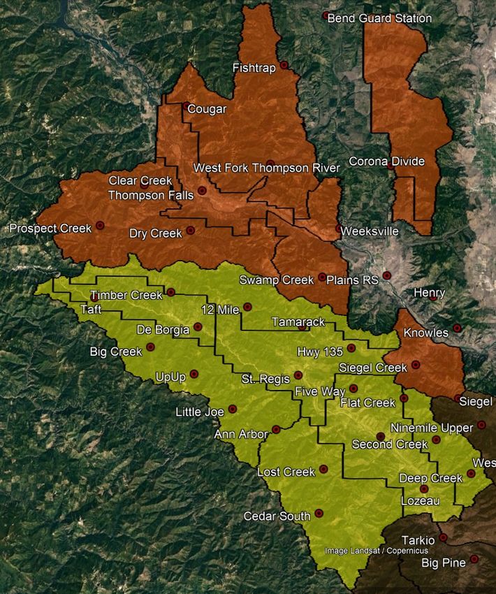
•   Incidents that local volunteer fire departments have responded to or are on scene and are
           requesting no additional resources.

                           Limited Response Plan (Lightning Mode/Protocol?):
                     (When implemented, will it be by Unit/District or across entire FDRA?)

   Periodically the Missoula Dispatch Zone experiences widespread lightning activity resulting in numerous
starts, many of these single tree lightning strikes. It is not possible to dispatch the number and type of
resources called for in the run card plan to each of these fires. This plan is designed to provide guidance to
Missoula Dispatch Center in order to coordinate an initial response under these multiple start conditions
generally considered 3 or more starts.

   Under circumstances where multiple starts are likely to occur (i.e. forecasted LAL 6) or are occurring and
each FDRA is at a Dispatch Response Level of Moderate or High, run card utilization may be suspended and
guidance provided by District/Unit Duty Officer for initial response to new starts. If possible, it is desired that
the appropriate Agency Duty Officer meet at MDC (Missoula Dispatch Center) to provide coordinated
guidance to the floor supervisor. A MAC call may be initiated if meeting in person is not possible.

Duty Officers should consider using the following priorities for dispatching resources*:
   1. When there is a direct threat to human life
   2. When there is a direct threat to homes or communities
   3. When there is a direct threat to other high value infrastructure or improvements
   4. All others

    Until such time as the Duty Officers can provide coordinated direction, the Dispatch Center floor supervisor
is authorized to determine the fire priorities based on given direction and make modifications to the
established run card response during multiple start events.

   During circumstances where there are no longer resources available to be dispatched to a new smoke
report, dispatch staff will notify the District/Unit Duty Officer of each new report and they will, considering the
priorities mentioned above, make a determination of needed staffing adjustments and provide guidance to
dispatch staff as to what resources to dispatch to each new smoke report.

   *Additionally, if on any given day when all FDRAs are at a Dispatch Response Level of Moderate or High and
Missoula Dispatch Center recognizes the inability of daily staffed resources to fulfill a dispatch of any run card
then the Dispatch Response Plan/run cards may be suspended, and any start would use the prioritization
process as identified above.
                                                    WildCAD:
   MDC uses WildCAD, a computer assisted dispatching application, to dispatch and track resources. For run
cards to be functional within WildCAD, updated maps with Response Areas and Dispatch Locations must be
established. WildCAD then utilizes these as reference points to determine the applicable run card for and
closest resources to a reported incident.

                                                                                                                      5
Terminology
Response Area - Pre-established geographic boundaries encompassing protection areas with similar
management objectives, land use, fire load, access, topography, fuel type and loading, etc.
Dispatch Location - Pre-established geographic locations representative of the general area. Fire resources are
expected to reference appropriate dispatch locations when calling into service.
Center Point - A center point is established within each response area. When a fire is reported within a
response area WildCAD uses this center point as a reference to determine the closest resource based on their
current dispatch location.
Run-Card Daily Responsibilities/Procedures:
Below is a brief overview of some of the daily procedures expected of Missoula Dispatch and fire
resources to facilitate proper run card response/functioning. These are not all encompassing but meant to
provide examples on some inputs needed for the successful implementation of run cards.
MDC Responsibilities
Reference Daily Resource Status Summary webpage and put all identified resources available quarters
in WildCAD by 1000. Call appropriate Duty Officer if website has not been updated by 1000.
o This will establish what resources are available for dispatch.
Set Dispatch Response Levels in WildCAD twice a day (0930/1530) based on identified observed (p.m.)
and forecasted (a.m.) indices. See chart on page 7 for how Dispatch Response Levels are determined.
o Designated Dispatch Response Level (Low, Moderate, High) determines what portion of the Run
Card to “read” and the number and type of resources in the pre-established response.
Appropriately status resources as they update dispatch with changes to locations and status.
Dispatch resources to reported wildland fires using tone out script. See Appendix A for example of
script.
Resource Responsibilities
Update Daily Resource Status Summary Page, by 1000, with all fire resources available for the day as
well as any out of area resources in zone on assignment.
Call into service referencing call sign, specific location in service to, as well as appropriate dispatch
location.
o MDC will put resources in service by call sign to the dispatch location they designate while also
recording specific location info provided.
o When a fire is reported, WildCAD will look for closest available resources based on their
dispatch location. If resources do not reference a dispatch location when calling into service,
the dispatcher must guess/assume resources’ location, thereby creating a potential for that
resource to be passed by for another resource who is “correctly” statused and shows closer to
incident.
Update dispatch when changing locations and when status changes (Available for IA from current
incident, etc.)
Provide acknowledgement of fire dispatch/tone out upon dispatch checkback.
o This will provide positive confirmation that a resource has received dispatch
When on scene of incident provide dispatch with a brief arrival report while preparing full size up. See
Appendix A for example of arrival report.
6ERC, BI, and DRL Tables
ERC Decision Threshold Ranges in all FDRA’s.
Decision Lolo DNRC Lolo DNRC CSKT CSKT Bitterroot Bitterroot
Threshold Ranges East West East West Low High
Low-PL 1 0-21.9 0-23.9 0-20.9 0-31.9 0-23.9 0-16.9
0% - ˂40%
Moderate-PL 2 22-39.9 24-41.9 21-32.9 32-49.9 24-42.9 17-39.9
˃40% - ˂80%
High-PL 3 40-45.9 42-47.9 33-37.9 50-56.9 43-47.9 40-45.9
˃80% - ˂90%
Very High-PL 4 46-51.9 48-54.9 38-43.9 57-64.9 48-52.9 46-50.9
˃90% - ˂97%
Extreme-PL 5 52+ 55+ 44+ 65+ 53+ 51+
˃97%
BI Decision Threshold Ranges in all FDRA’s.
Decision Lolo DNRC Lolo DNRC CSKT CSKT Bitterroot Bitterroot
Threshold Ranges East West East West Low High
Low 0-21.9 0-25.9 0-24.9 0-20.9 0-36.9 0-32.9
Moderate 22-37.9 26-45.9 25-33.9 21-39.9 37-46.9 33-41.9
High 38+ 46+ 34+ 40+ 47+ 42+
˃97%
Dispatch Response Level Matrix
Dispatch Response Level
H Low Low Mod High High +
BI Class M Low Low Mod Mod High
L Low Low Low Mod Mod
1 2 3 4 5
ERC Class
7Missoula Dispatch Zone Response Areas
8Run Cards
West Zone
(Zoomed Map)
95-PLNO D5 – Plains North
Plains / Thompson Falls Ranger District
West Zone Radio Group / West FDRA
DISPATCH RESPONSE LEVEL LOW MODERATE HIGH
RESOURCES (MINIMUM) Call Duty Officer 1 IA Module 1 Engine
1 IA Module
DISPATCH COMMENTS
SHARED BOUNDARY:
• Determine if Sanders County 911 has dispatched Plains and/or Thompson Falls RFD.
• Notify responding resources of RFD status.
• If smoke report is within 1 mile of DNRC or CSKT protection, notify appropriate Dispatch Center
IF AIRCRAFT IS ORDERED:
• Ensure helicopter is (or can be) configured to air drop water on the fire (bucket or tank).
KNOWN HAZARDS:
•
NOTIFICATIONS:
• District Duty Officer
DUTY OFFICER CONSIDERATIONS:
• Determine if additional resources are necessary.
• Make standard notifications.
• If it is a human start, order LE & I and/or INVF.
5-PLNO center point = Corona Divide 47.649447° and -114.874602°
5-PLNE D5 – Plains Northeast
Plains / Thompson Falls Ranger District
West Zone Radio Group / West FDRA
DISPATCH RESPONSE LEVEL LOW MODERATE HIGH
RESOURCES (MINIMUM) Call Duty Officer 1 IA Module 1 Engine
1 IA Module
DISPATCH COMMENTS
SHARED BOUNDARY:
• Determine if Sanders County 911 has dispatched Plains and/or Thompson Falls RFD.
• Notify responding resources of RFD status.
• If smoke report is within 1 mile of DNRC or CSKT protection, notify appropriate Dispatch Center
IF AIRCRAFT IS ORDERED:
• Ensure helicopter is (or can be) configured to air drop water on the fire (bucket or tank).
KNOWN HAZARDS:
• BPA 500 kV power lines.
NOTIFICATIONS:
• District Duty Officer
DUTY OFFICER CONSIDERATIONS:
• Determine if additional resources are necessary.
• Make standard notifications.
• If it is a human start, order LE & I and/or INVF.
5-PLNE center point = Blanchard Corner 47.556574° and -114.871726°
105-PLSE D5 – Plains Southeast
Plains / Thompson Falls Ranger District
West Zone Radio Group / West FDRA
DISPATCH RESPONSE LEVEL LOW MODERATE HIGH
RESOURCES (MINIMUM) Call Duty Officer 1 IA Module 1 Engine
1 IA Module
DISPATCH COMMENTS
SHARED BOUNDARY:
• Determine if Sanders County 911 has dispatched Plains and/or Thompson Falls RFD.
• Notify responding resources of RFD status.
• If smoke report is within 1 mile of DNRC or CSKT protection, notify appropriate Dispatch Center
IF AIRCRAFT IS ORDERED:
• Ensure helicopter is (or can be) configured to air drop water on the fire (bucket or tank).
KNOWN HAZARDS:
• BPA 500 kV power lines.
NOTIFICATIONS:
• District Duty Officer
DUTY OFFICER CONSIDERATIONS:
• Determine if additional resources are necessary.
• Make standard notifications.
• If it is a human start, order LE & I and/or INVF.
5-PLSE center point = 135/200 Hwy Junction 47.354321° and -114.778781°
5-PLSW D5 – Plains Southwest
Plains / Thompson Falls Ranger District
West Zone Radio Group / West FDRA
DISPATCH RESPONSE LEVEL LOW MODERATE HIGH
RESOURCES (MINIMUM) Call Duty Officer 1 IA Module 1 Engine
1 IA Module
DISPATCH COMMENTS
SHARED BOUNDARY:
• Determine if Sanders County 911 has dispatched Plains and/or Thompson Falls RFD.
• Notify responding resources of RFD status.
• If smoke report is within 1 mile of DNRC or CSKT protection, notify appropriate Dispatch Center
IF AIRCRAFT IS ORDERED:
• Ensure helicopter is (or can be) configured to air drop water on the fire (bucket or tank).
KNOWN HAZARDS:
• BPA 500 kV power lines.
NOTIFICATIONS:
• District Duty Officer
DUTY OFFICER CONSIDERATIONS:
• Determine if additional resources are necessary.
• Make standard notifications.
• If it is a human start, order LE & I and/or INVF.
5-PLSW center point = Swamp Cr. – D5 47.461497° and -115.04233°
115-PLWE D5 – Plains West
Plains / Thompson Falls Ranger District
West Zone Radio Group / West FDRA
DISPATCH RESPONSE LEVEL LOW MODERATE HIGH
RESOURCES (MINIMUM) Call Duty Officer 1 IA Module 1 Engine
1 IA Module
DISPATCH COMMENTS
SHARED BOUNDARY:
• Determine if Sanders County 911 has dispatched Plains and/or Thompson Falls RFD.
• Notify responding resources of RFD status.
• If smoke report is within 1 mile of DNRC or CSKT protection, notify appropriate Dispatch Center
IF AIRCRAFT IS ORDERED:
• Ensure helicopter is (or can be) configured to air drop water on the fire (bucket or tank).
KNOWN HAZARDS:
• BPA 500 kV power lines.
NOTIFICATIONS:
• District Duty Officer
DUTY OFFICER CONSIDERATIONS:
• Determine if additional resources are necessary.
• Make standard notifications.
• If it is a human start, order LE & I and/or INVF.
5-PLWE center point = 5587/887 Rd Junction 47.568681° and -115.005753°
5-TFLN D5 – Thompson Falls North
Plains / Thompson Falls Ranger District
West Zone Radio Group / West FDRA
DISPATCH RESPONSE LEVEL LOW MODERATE HIGH
RESOURCES (MINIMUM) Call Duty Officer 1 IA Module 1 Engine
1 IA Module
DISPATCH COMMENTS
SHARED BOUNDARY:
• If smoke report is within 1 mile of DNRC or Kootenai NF protection, notify appropriate Dispatch Center
IF AIRCRAFT IS ORDERED:
• Ensure helicopter is (or can be) configured to air drop water on the fire (bucket or tank).
KNOWN HAZARDS:
•
NOTIFICATIONS:
• District Duty Officer
DUTY OFFICER CONSIDERATIONS:
• Determine if additional resources are necessary.
• Make standard notifications.
• If it is a human start, order LE & I and/or INVF.
5-TFLN center point = West Fork Thompson River – D5 47.649787° and -115.174427°
125-TFLC D5 – Thompson Falls Central
Plains / Thompson Falls Ranger District
West Zone Radio Group / West FDRA
DISPATCH RESPONSE LEVEL LOW MODERATE HIGH
RESOURCES (MINIMUM) Call Duty Officer 1 IA Module 1 Engine
1 IA Module
DISPATCH COMMENTS
SHARED BOUNDARY:
• Determine if Sanders County 911 has dispatched Plains and/or Thompson Falls RFD.
• Notify responding resources of RFD status.
• If smoke report is within 1 mile of Kootenai NF protection, notify appropriate Dispatch Center.
IF AIRCRAFT IS ORDERED:
• Ensure helicopter is (or can be) configured to air drop water on the fire (bucket or tank).
KNOWN HAZARDS:
• BPA 500 kV power lines.
NOTIFICATIONS:
• District Duty Officer
DUTY OFFICER CONSIDERATIONS:
• Determine if additional resources are necessary.
• Make standard notifications.
• If it is a human start, order LE & I and/or INVF.
5-TFLC center point = Thompson Falls W.C. – D5 47.603935° and -115.343771 °
5-TFLS D5 – Thompson Falls South
Plains / Thompson Falls Ranger District
West Zone Radio Group / West FDRA
DISPATCH RESPONSE LEVEL LOW MODERATE HIGH
RESOURCES (MINIMUM) Call Duty Officer 1 IA Module 1 Engine
1 IA Module
DISPATCH COMMENTS
SHARED BOUNDARY:
• If smoke report is within 1 mile of Kootenai NF or Idaho Panhandle NF protection, notify appropriate
Dispatch Center
IF AIRCRAFT IS ORDERED:
• Ensure helicopter is (or can be) configured to air drop water on the fire (bucket or tank).
KNOWN HAZARDS:
• BPA 500 kV power lines.
NOTIFICATIONS:
• District Duty Officer
DUTY OFFICER CONSIDERATIONS:
• Determine if additional resources are necessary.
• Make standard notifications.
• If it is a human start, order LE & I and/or INVF.
5-TFLS center point = Clear Cr. – D5 47.612268 ° and -115.488136°
137-WENO D7 – West End North
Superior Ranger District
West Zone Radio Group / West FDRA
DISPATCH RESPONSE LEVEL LOW MODERATE HIGH
RESOURCES (MINIMUM) Call Duty Officer 1 Engine 1 Engine
1 IA Module
1 Helicopter
DISPATCH COMMENTS
SHARED BOUNDARY:
• If the smoke report is within 2 air miles of the state line, notify Coeur d’Alene Dispatch Center.
IF AIRCRAFT IS ORDERED:
• Ensure helicopter is (or can be) configured to air drop water on the fire (bucket or tank).
• Big Creek Gravel Pit is available for initial and extended attack (47° 22.499', -115° 23.998').
KNOWN HAZARDS:
• BPA 500 kV power lines run east-west through the length of the 7-WENO Response Zone.
• BPA 500 kV power lines run north-south through the west portion of the 7-WENO Response Zone.
NOTIFICATIONS:
• District Duty Officer
DUTY OFFICER CONSIDERATIONS:
• Determine if additional resources are necessary.
• Make standard notifications
• If it is a human start, order LE & I and/or INVF
7-WENO center point = Dry Fork/Tamarack Junction – D7 47.3788° and -115.0911°
7-STRE D7 – Saint Regis Area WUI
Superior Ranger District
West Zone Radio Group / West FDRA
DISPATCH RESPONSE LEVEL LOW MODERATE HIGH
RESOURCES (MINIMUM) Call Duty Officer 1 Engine 1 Engine
1 IA Module
1 Helicopter
DISPATCH COMMENTS
SHARED BOUNDARY:
• Determine if Mineral County 911 has dispatched RVFD.
• Notify responding resources of RVFD status.
IF AIRCRAFT IS ORDERED:
• Ensure helicopter is (or can be) configured to air drop water on the fire (bucket or tank).
• St Regis Helibase available for initial and extended attack (47° 18.259', -115° 06.478').
KNOWN HAZARDS:
• BPA 500 kV power lines are near and occasionally are in 7-STRE Response Zone.
NOTIFICATIONS:
• District Duty Officer
DUTY OFFICER CONSIDERATIONS:
• Determine if additional resources are necessary.
• Make standard notifications
• If it is a human start, order LE & I and/or INVF
7-STRE center point = St. Regis Exit 33 – D7 47.2964° and -115.0998°
147-DBGA D7 – West End (Saltese / Haugan / De Borgia) WUI
Superior Ranger District
West Zone Radio Group / West FDRA
DISPATCH RESPONSE LEVEL LOW MODERATE HIGH
RESOURCES (MINIMUM) Call Duty Officer 1 Engine 1 Engine
1 IA Module
1 Helicopter
DISPATCH COMMENTS
SHARED BOUNDARY:
• Determine if Mineral County 911 has dispatched RVFD.
• Notify responding resources of RVFD status.
IF AIRCRAFT IS ORDERED:
• Ensure helicopter is (or can be) configured to air drop water on the fire (bucket or tank).
• Big Creek Gravel Pit is available for initial and extended attack (47° 22.499', -115° 23.998').
KNOWN HAZARDS:
• BPA 500 kV power lines are near and occasionally are in DBGA-7 Response Zone.
• BPA 500 kV power lines cross I-90 near Rainy Creek in the DBGA-7 Response Zone.
NOTIFICATIONS:
• District Duty Officer
DUTY OFFICER CONSIDERATIONS:
• Determine if additional resources are necessary.
• Make standard notifications
• If it is a human start, order LE & I and/or INVF
7-DBGA center point = De Borgia Exit 18 – D7 47.3757° and -115.3497°
7-WESO D7 – West End South
Superior Ranger District
West Zone Radio Group / West FDRA
DISPATCH RESPONSE LEVEL LOW MODERATE HIGH
RESOURCES (MINIMUM) Call Duty Officer 1 Engine 1 Engine
1 IA Module
1 Helicopter
DISPATCH COMMENTS
SHARED BOUNDARY:
• If the smoke report is within 2 air miles of the state line, notify Coeur d’Alene Dispatch Center.
IF AIRCRAFT IS ORDERED:
• Ensure helicopter is (or can be) configured to air drop water on the fire (bucket or tank).
• Big Creek Gravel Pit is available for initial and extended attack (47° 22.499', -115° 23.998').
• St Regis Helibase available for initial and extended attack (47° 18.259', -115° 06.478').
KNOWN HAZARDS:
• BPA 500 kV power lines run NW-SE through the west portion of the 7-WESO Response Zone.
NOTIFICATIONS:
• District Duty Officer
DUTY OFFICER CONSIDERATIONS:
• Determine if additional resources are necessary.
• Make standard notifications
• If it is a human start, order LE & I and/or INVF
7-WESO center point = Newman Ridge – D7 47.2854° and -115.2487°
157-EESO D7 – East End South
Superior Ranger District
West Zone Radio Group / West FDRA
DISPATCH RESPONSE LEVEL LOW MODERATE HIGH
RESOURCES (MINIMUM) Call Duty Officer 1 Engine 1 Engine
1 IA Module
1 Helicopter
DISPATCH COMMENTS
SHARED BOUNDARY:
• If the smoke report is within 2 air miles of the state line, notify the appropriate dispatch center (Coeur
d’Alene Dispatch Center or Grangeville Dispatch Center).
IF AIRCRAFT IS ORDERED:
• Ensure helicopter is (or can be) configured to air drop water on the fire (bucket or tank).
• Mineral County Airport (9S4) is available for initial attack (47° 10.092’, -114° 51.229’).
• If aircraft does R.O.N. at 9S4, initiate LUA.
KNOWN HAZARDS:
• N/A
NOTIFICATIONS:
• District Duty Officer
DUTY OFFICER CONSIDERATIONS:
• Determine if additional resources are necessary.
• Make standard notifications
• If it is a human start, order LE & I and/or INVF
7-EESO center point = Cayuse Saddle – D7 47.1273° and -115.0042°
7-SUPR D7 – Superior Area WUI
Superior Ranger District
West Zone Radio Group / West FDRA
DISPATCH RESPONSE LEVEL LOW MODERATE HIGH
RESOURCES (MINIMUM) Call Duty Officer 1 Engine 1 Engine
1 IA Module
1 Helicopter
DISPATCH COMMENTS
SHARED BOUNDARY:
• Determine if Mineral County 911 has dispatched RVFD.
• Notify responding resources of RVFD status.
IF AIRCRAFT IS ORDERED:
• Ensure helicopter is (or can be) configured to air drop water on the fire (bucket or tank).
• Mineral County Airport (9S4) is available for initial attack (47° 10.092’, -114° 51.229’).
• If aircraft does R.O.N. at 9S4, initiate LUA.
KNOWN HAZARDS:
• BPA 500 kV power lines are north of and occasionally are in 7-SUPR Response Zone.
NOTIFICATIONS:
• District Duty Officer
DUTY OFFICER CONSIDERATIONS:
• Determine if additional resources are necessary.
• Make standard notifications
• If it is a human start, order LE & I and/or INVF
7-SUPR center point = Superior Exit 47 – D7 47.1920° and -114.8909°
167-EENO D7 – East End North
Superior Ranger District
West Zone Radio Group / West FDRA
DISPATCH RESPONSE LEVEL LOW MODERATE HIGH
RESOURCES (MINIMUM) Call Duty Officer 1 Engine 1 Engine
1 IA Module
1 Helicopter
DISPATCH COMMENTS
SHARED BOUNDARY:
• N/A
IF AIRCRAFT IS ORDERED:
• Ensure helicopter is (or can be) configured to air drop water on the fire (bucket or tank).
• Mineral County Airport (9S4) is available for initial attack (47° 10.092’, -114° 51.229’).
• If aircraft does R.O.N. at 9S4, initiate LUA.
KNOWN HAZARDS:
• BPA 500 kV power lines run east-west through the length of the 7-EENO Response Zone.
NOTIFICATIONS:
• District Duty Officer
DUTY OFFICER CONSIDERATIONS:
• Determine if additional resources are necessary.
• Make standard notifications
• If it is a human start, order LE & I and/or INVF
7-EENO center point = Johnson Creek – D7 47.2125° and -114.8099°
17Central Zone
(Zoomed Map)
184-9MIL D4 – 9Mile Mountains
Ninemile Ranger District
CENTRAL Zone Radio Group / East FDRA
DISPATCH RESPONSE LEVEL LOW MODERATE HIGH
RESOURCES (MINIMUM) 1 Engine 1 Engine 1 Engine
DISPATCH COMMENTS
SHARED BOUNDARY:
• Determine if Missoula County 911 has dispatched FTRF, DNRC and/or notified adjacent cooperators within
one mile of the new start.
• Notify responding resources of RVFD/co-operator status.
IF AIRCRAFT IS ORDERED:
• Ensure helicopter is (or can be) configure for long line and bucket work.
• Ninemile Airstrip is available for initial attack.
KNOWN HAZARDS:
• BPA Powerlines running south and west in the response area.
• Kreis Pond recreational site
NOTIFICATIONS:
• District Duty Officer
• Forest Duty Officer
• Ninemile District Ranger within one mile of co-operator(s) boundary.
DUTY OFFICER CONSIDERATIONS:
• District and Forest Duty Officer
• Ninemile District Ranger within one mile of co-operator(s) boundary.
4-9MIL center point = Kries Pond 47.100642° and -114.425269°
4-9MVY D4 – 9Mile Valley
Ninemile Ranger District
CENTRAL Zone Radio Group / East FDRA
DISPATCH RESPONSE LEVEL LOW MODERATE HIGH
RESOURCES (MINIMUM) 1 Engine 1 Engine 1 Engine
DISPATCH COMMENTS
SHARED BOUNDARY:
• Determine if Missoula County 911 has dispatched FTRF, DNRC and/or notified adjacent cooperators within
one mile of the new start.
• Notify responding resources of RVFD/co-operator status.
IF AIRCRAFT IS ORDERED:
• Ensure helicopter is (or can be) configure for long line and bucket work and troop shuttle.
• Ninemile Airstrip is available for initial attack.
KNOWN HAZARDS:
• Populated W.U.I. area.
• Heavy traffic along main Ninemile Valley Road
NOTIFICATIONS:
• District and Forest Duty Officer
• Ninemile District Ranger within one mile of co-operator(s) boundary.
DUTY OFFICER CONSIDERATIONS:
• Determine if additional resources are necessary.
• Make standard notifications.
• If it is a human start, order LEO or qualified Fire Investigator
4-9MVY center point = 47.104253 ° and -114.480760°
194-STRK D4 – Stark Mountain
Ninemile Ranger District
CENTRAL Zone Radio Group / West FDRA
DISPATCH RESPONSE LEVEL LOW MODERATE HIGH
RESOURCES (MINIMUM) 1 Engine 1 Engine 1 Engine
DISPATCH COMMENTS
SHARED BOUNDARY:
• Determine if Missoula County 911 has dispatched FTRF, DNRC and/or notified adjacent cooperators within
one mile of the new start.
• Notify responding resources of RVFD/co-operator status.
IF AIRCRAFT IS ORDERED:
• Ensure helicopter is (or can be) configure for long line, bucket work and troop shuttle.
• Ninemile Airstrip/Sawmill Gulch Helispot are available for initial attack support.
KNOWN HAZARDS:
• BPA Powerlines running through the middle of the response area.
• Heavy summer traffic along the I-90 corridor
NOTIFICATIONS:
• District and Forest Duty Officer
• Ninemile District Ranger within one mile of co-operator(s) boundary.
DUTY OFFICER CONSIDERATIONS:
• Determine if additional resources are necessary.
• Make standard notifications.
• If it is a human start, order LEO or qualified Fire Investigator
4-STRK center point = Sheridan Creek 47.064490° and -114.621877°
4-NFSH D4 – North Fish Creek
Ninemile Ranger District
CENTRAL Zone Radio Group / West FDRA
DISPATCH RESPONSE LEVEL LOW MODERATE HIGH
RESOURCES (MINIMUM) 1 Engine 1 Engine 1 Engine
DISPATCH COMMENTS
SHARED BOUNDARY:
• Determine if Missoula County 911 has dispatched FTRF, DNRC and/or notified adjacent cooperators within
one mile of the new start.
• Notify responding resources of RVFD/co-operator status.
IF AIRCRAFT IS ORDERED:
• Ensure helicopter is (or can be) configure for long line, bucket work and troop Shuttle.
• Ninemile Airstrip/Sawmill Gulch Helispot are available for initial attack support.
KNOWN HAZARDS:
• Heavy recreational traffic along the main Fish Creek road in the summer and fall.
• Poor road access in the area consider aircraft if needed for emergency support.
NOTIFICATIONS:
• District and Forest Duty Officer
• Ninemile District Ranger within one mile of co-operator(s) boundary.
DUTY OFFICER CONSIDERATIONS:
• Determine if additional resources are necessary.
• Make standard notifications.
• If it is a human start, order LEO or qualified Fire Investigator
4-NFSH center point = Big Pine 46.990710° and -114.661923°
204-GRBN D4 – Great Burn
Ninemile Ranger District
CENTRAL Zone Radio Group / West FDRA
DISPATCH RESPONSE LEVEL LOW MODERATE HIGH
RESOURCES (MINIMUM) 1 Engine 1 Engine 1 Engine
DISPATCH COMMENTS
SHARED BOUNDARY:
• Determine if Mineral County 911 has dispatched Superior Ranger District and/or notified adjacent co-
operators within one mile of the new start.
• Notify responding resources of RVFD/co-operator status.
IF AIRCRAFT IS ORDERED:
• Ensure helicopter is (or can be) configure for long line, bucket work and troop shuttle.
• Ninemile Airstrip/Beaver Ponds Helispot are available for initial attack support.
KNOWN HAZARDS:
• This area falls into a proposed wilderness category and emergency access can be limited.
NOTIFICATIONS:
• District and Forest Duty Officer
• Ninemile District Ranger within one mile of co-operator(s) boundary.
DUTY OFFICER CONSIDERATIONS:
• Determine if additional resources are necessary.
• Make standard notifications.
• If it is a human start, order LEO or qualified Fire Investigator
4-GRBN center point = Straight Peak 47.882851° and -114.894422°
4-SFSH D4 – South Fish Creek
Ninemile Ranger District
CENTRAL Zone Radio Group / West FDRA
DISPATCH RESPONSE LEVEL LOW MODERATE HIGH
RESOURCES (MINIMUM) 1 Engine 1 Engine 1 Engine
DISPATCH COMMENTS
SHARED BOUNDARY:
• Determine if Missoula County 911 has dispatched FTRF, DNRC and/or notified adjacent cooperators within
one mile of the new start.
• Notify responding resources of RVFD/co-operator status.
IF AIRCRAFT IS ORDERED:
• Ensure helicopter is (or can be) configure for long line, bucket work and troop shuttle.
• Ninemile Airstrip/Beaver Pond Helispot are available for initial attack support.
KNOWN HAZARDS:
• Much of this country is in an Inventoried Roadless Area and access is limited.
NOTIFICATIONS:
• District Duty Officer
• Forest Duty Officer
• Ninemile District Ranger within one mile of co-operator(s) boundary.
DUTY OFFICER CONSIDERATIONS:
• Determine if additional resources are necessary.
• Make standard notifications.
• If it is a human start, order LEO or qualified Fire Investigator
4-SFSH center point = Surveyor Creek 46.843955° and -114.707192°
214-BRDT D4 – Burdette
Ninemile Ranger District
CENTRAL Zone Radio Group / West FDRA
DISPATCH RESPONSE LEVEL LOW MODERATE HIGH
RESOURCES (MINIMUM) 1 Engine 1 Engine 1 Engine
DISPATCH COMMENTS
SHARED BOUNDARY:
• Determine if Missoula County 911 has dispatched FTRF, DNRC and/or notified adjacent cooperators within
one mile of the new start.
• Notify responding resources of RVFD/co-operator status.
IF AIRCRAFT IS ORDERED:
• Ensure helicopter is (or can be) configure for long line, bucket work and troop shuttle.
• Ninemile Airstrip/Beaver Pond Helispot are available for initial attack support.
KNOWN HAZARDS:
• Much of this country is in an Inventoried Roadless Area and access is limited.
NOTIFICATIONS:
• District and Forest Duty Officer
• Ninemile District Ranger within one mile of co-operator(s) boundary.
DUTY OFFICER CONSIDERATIONS:
• Determine if additional resources are necessary.
• Make standard notifications.
• If it is a human start, order LEO or qualified Fire Investigator
4-BRDT center point = Ridge Top East of Burdette Creek 47.862296° and -114.588298°
4-WPTY D4 – West Petty Creek
Ninemile Ranger District
CENTRAL Zone Radio Group / East FDRA
DISPATCH RESPONSE LEVEL LOW MODERATE HIGH
RESOURCES (MINIMUM) 1 Engine 1 Engine 1 Engine
DISPATCH COMMENTS
SHARED BOUNDARY:
• Determine if Missoula County 911 has dispatched FTRF, DNRC and/or notified adjacent cooperators within
one mile of the new start.
• Notify responding resources of RVFD/co-operator status.
IF AIRCRAFT IS ORDERED:
• Ensure helicopter is (or can be) configure for long line, bucket work and troop shuttle.
• Ninemile Airstrip/Sawmill Gulch are available for initial attack support.
KNOWN HAZARDS:
• BPA Powerlines running northeast in the response area.
• Heavy traffic in the summertime along the main Petty Creek road.
NOTIFICATIONS:
• District and Forest Duty Officer
• Ninemile District Ranger within one mile of co-operator(s) boundary.
DUTY OFFICER CONSIDERATIONS:
• Determine if additional resources are necessary.
• Make standard notifications.
• If it is a human start, order LEO or qualified Fire Investigator
4-WPTY center point = 47.100642° and -114.425269°
224-EPTY D4 – East Petty Creek
Ninemile Ranger District
CENTRAL Zone Radio Group / East FDRA
DISPATCH RESPONSE LEVEL LOW MODERATE HIGH
RESOURCES (MINIMUM) 1 Engine 1 Engine 1 Engine
DISPATCH COMMENTS
SHARED BOUNDARY:
• Determine if Missoula County 911 has dispatched FTRF, DNRC and/or notified adjacent cooperators within
one mile of the new start.
• Notify responding resources of RVFD/co-operator status.
IF AIRCRAFT IS ORDERED:
• Ensure helicopter is (or can be) configure for long line, bucket work and troop shuttle.
• Ninemile Airstrip is available for initial attack.
KNOWN HAZARDS:
• High traffic concentrations in the summer along main Petty Creek road
NOTIFICATIONS:
• District and Forest Duty Officer
• Ninemile District Ranger within one mile of co-operator(s) boundary.
DUTY OFFICER CONSIDERATIONS:
• Determine if additional resources are necessary.
• Make standard notifications.
• If it is a human start, order LEO or qualified Fire Investigator
4-EPTY center point = 46.880842° and -114.438317°
4-ALBR D4 – Albert Point
Ninemile Ranger District
CENTRAL Zone Radio Group / East FDRA
DISPATCH RESPONSE LEVEL LOW MODERATE HIGH
RESOURCES (MINIMUM) 1 Engine 1 Engine 1 Engine
DISPATCH COMMENTS
SHARED BOUNDARY:
• Determine if Missoula County 911 has dispatched FTRF, DNRC and/or notified adjacent cooperators within
one mile of the new start.
• Notify responding resources of RVFD/co-operator status.
IF AIRCRAFT IS ORDERED:
• Ensure helicopter is (or can be) configure for long line, bucket work and troop shuttle.
• Ninemile Airstrip is available for initial attack.
KNOWN HAZARDS:
• BPA Powerlines running north and east of Albert Point.
• South Side road traffic.
NOTIFICATIONS:
• District Forest Duty Officer
• Ninemile District Ranger within one mile of co-operator(s) boundary.
DUTY OFFICER CONSIDERATIONS:
• Determine if additional resources are necessary.
• Make standard notifications.
• If it is a human start, order LEO or qualified Fire Investigator
4-ALBR center point = Petty Mountain 47.911528° and -114.405995°
234-WSSR D4 – West Southside
Ninemile Ranger District
CENTRAL Zone Radio Group / East FDRA
DISPATCH RESPONSE LEVEL LOW MODERATE HIGH
RESOURCES (MINIMUM) 1 Engine 1 Engine 1 Engine
DISPATCH COMMENTS
SHARED BOUNDARY:
• Determine if Missoula County 911 has dispatched FTRF, DNRC and/or notified adjacent cooperators within
one mile of the new start.
• Notify responding resources of RVFD/co-operator status.
IF AIRCRAFT IS ORDERED:
• Ensure helicopter is (or can be) configure for long line, bucket work and troop shuttle.
• Ninemile Airstrip/Sawmill Gulch are available for initial attack support.
KNOWN HAZARDS:
• BPA Powerlines running northeast in the response area.
• Watch for traffic and camping along the South Side road.
• Train tracks run along the northern portion of the response area.
NOTIFICATIONS:
• District and Forest Duty Officer
• Ninemile District Ranger within one mile of co-operator(s) boundary.
DUTY OFFICER CONSIDERATIONS:
• Determine if additional resources are necessary.
• Make standard notifications.
• If it is a human start, order LEO or qualified Fire Investigator
4-WSSR center point = 46.994313° and -114.380686°
4-LG04FT D4 – Frenchtown Cnty Response
Ninemile Ranger District
CENTRAL Zone Radio Group / East FDRA
DISPATCH RESPONSE LEVEL LOW MODERATE HIGH
RESOURCES (MINIMUM) 1 Engine 1 Engine 1 Engine
DISPATCH COMMENTS
SHARED BOUNDARY:
• Determine if Missoula County 911 has dispatched FTRF, DNRC and/or notified adjacent cooperators within
one mile of the new start.
• Notify responding resources of RVFD/co-operator status.
IF AIRCRAFT IS ORDERED:
• Ensure helicopter is (or can be) configure for long line and bucket work.
• Ninemile Airstrip is available for initial attack support.
KNOWN HAZARDS:
• I-90 corridor traffic that runs along the south of the response area.
NOTIFICATIONS:
• District and Forest Duty Officer
• Ninemile District Ranger within one mile of co-operator(s) boundary.
DUTY OFFICER CONSIDERATIONS:
• Determine if additional resources are necessary.
• Make standard notifications.
• If it is a human start, order LEO or qualified Fire Investigator
LG04FT center point = 47.022113° and -114.290676°
243-WES1 D3 – Blue Mountain
Missoula Ranger District
CENTRAL Zone Radio Group / East FDRA
DISPATCH RESPONSE LEVEL LOW MODERATE HIGH
RESOURCES (MINIMUM) Notify Duty Officer 1 Engine 1 Engine
1 Utility
ICT4
*Utility = IA Mod. Resources will call in and be dispatched as “Utility___”
DISPATCH COMMENTS
SHARED BOUNDARY:
• Notify the following if within 1 mile of boundary:
o Ninemile Ranger District/Lolo National Forest/USFS.
o Missoula Unit/MT-DNRC.
o Missoula City Fire has fire protection responsibilities in this response area.
o Missoula Rural Fire Dept. has fire protection responsibilities in this response area.
IF AIRCRAFT IS ORDERED:
• DIPSITES
o Bitterroot River.
o Lolo Creek.
o Huckeby (private): N46° 53.760’ x W114° 17.397’ confluence of Deep/Gilman Creeks
o Grave Creek dipsite (private): N46° 48.178’ x W114° 24.148’
• HELIBASE
o Missoula airport.
o OZ Ranch helibase (private): N46° 45.729’ x W114° 16.613’
• MEDEVAC SITES
o Blue Mtn. Rec Area Medevac (FS): N46° 49.606’x W113° 5.831’ (in wagon wheel).
o OZ Ranch helibase (private): N46° 45.729’ x W114° 16.613’
o Huckeby Medevac (private): N46° 53.760’ x W114° 17.397’
o Dry Gulch Medevac (FS): N46° 51.843’ x W114° 15.731’
o Woodman Saddle Medevac (FS): N46° 48.599’ x W114° 12.781’
o Blue Mountain Medevac (FS): N46° 48.913’ x W114° 11.284’
o Grave Creek Medevac (private): N46° 48.082’ x W114° 24.083’
KNOWN HAZARDS:
• Local wildlife and domestic animals.
• BPA powerline.
• U.S. highway 12 traffic.
• In the event of an unwanted outcome, potential delays in getting adequate emergency care because
of some of the remoteness in this response area.
• Hikers/recreators in fire area with no quick routes of egress.
• One-way vehicle ingress and egress in O’Brien Creek.
• The Blue Mountain area has been known to host transient populations of greater Missoula. Be
vigilant about your safety if an interaction should occur. Report all camps to FS law enforcement
and district rec staff.
NOTIFICATIONS:
• Depending on location, Ninemile Ranger District duty officer.
• Depending on location, MT-DNRC duty officer.
• Power company if fires are near powerline corridors.
25DUTY OFFICER CONSIDERATIONS:
• ACCESS
o Good road and trail access in Blue Mountain Recreation Area and west to Woodman Saddle. Beyond
this network road access is fairly poor. Vast trail systems exist within Blue Mountain Recreation Area
for personnel to access on foot.
o There is decent road access into O’Brien Creek.
o Outside of Blue Mountain area, access is limited. Helicopter would be the recommended option for
inserting ground personnel.
o Some access exists via UTV along Grave Creek Range trail, towards Telephone Butte. This access
begins at Woodman Saddle (#17806).
• CAMPS
o For smaller incidents, potential exists in places like Woodman Saddle or Maclay Flat.
o For larger incidents, availability of the Missoula County Fairgrounds should be checked.
o A private field (Geraldine Ball) in Florence off the Eastside Hwy and Klements Rd. was used as ICP in
2017 for the Lolo Peak fire.
o Traveler’s Rest (MT-FWP) just west of Lolo, MT is an option that has been used in the past.
o Property off Kona Ranch Rd and Mullan Rd (Robert Samuel property) was used during the Black Mtn
fire in 2003.
• LAND USE AGREEMENTS
o Contact dispatch if land use agreements are needed as well as Mike Lucas on AQM fire dispatch
phone at #406-499-1099. Need owner name, address (as well as lat/long of property), phone
number, & preferably an email address for dispatch to cut resource order.
o Past land use agreements in this area are:
OZ Ranch helibase: N46° 45.729’ x W114° 16.613’
Huckeby dipsite: N46° 53.760’ x W114° 17.397’
Grave Creek dipsite: N46° 48.178’ x W114° 24.148’
Private field (Geraldine Ball) in Florence off the Eastside Hwy and Klements Rd. was used as
ICP in 2017 for the Lolo Peak fire.
Traveler’s Rest (MT-FWP) just west of Lolo is an option that has been used in the past.
Property off of Kona Ranch rd and Mullan rd (Robert Samuel property) was used during the
Black Mtn fire in 2003.
*Missoula Ranger District Fire Management Google COP has contact information
• MAJOR VALUES
o Blue Mountain Lookout.
o Residents in O’Brien Creek, Blue Mtn road, and Big Flat road area.
o Residents in Hayes Creek, Sleeman Creek, lower Hwy 12 corridor, Grave Creek.
o BPA powerlines.
o Blue Mountain Recreation Area (BMRA).
o Timber value in Blue Mountain area.
• OTHER CONSIDERATIONS
o If fires are within road corridors, consider law enforcement presence for traffic control.
o Fires in the Blue Mountain, O’Brien, and Sleeman Creek areas typically call for a mutual aid response,
so be prepared to use Red as the tactical frequency for the fire.
o Fires in the BMRA are historically started by humans, so pay careful attention to protecting fire
origins if possible.
o Lewis & Clark National Historic Trail in lower BMRA.
o The district has completed thinning and prescribed burning operations in the BMRA over the last
decade which should make widlfires a little easier to bring under control, whether that’s thru ignition
ops, hand tools/equipment, or a combination.
o When responding to fires in the BLMRA, be prepared to come upon all manners of recreational
activities, from walking, jogging, horseback riding, folfing, UTV’s and motorcycles.
3-WES1 center point = McClay Flat Trailhead 46.83555092° and -114.1043539°
26You can also read