Modern means of assessing the impact of emergencies on the environmental condition of the ground layer of atmosphere
←
→
Page content transcription
If your browser does not render page correctly, please read the page content below
E3S Web of Conferences 280, 09017 (2021)                                                               https://doi.org/10.1051/e3sconf/202128009017
ICSF 2021

         Modern means of assessing the impact of emergencies on the
         environmental condition of the ground layer of atmosphere
         Anastasiia Turevych1, Svitlana Madzhd1, Larysa Cherniak1, Anatoliy Pavlyuk2, and Vincent Ojeh3
         1NationalAviation University, Kyiv, Ukraine
         2Nikolaev Institute of Inorganic Chemistry, Siberian Branch of Russian Academy of Sciences, Novosibirsk, Russia
         3Taraba State University, Jalingo, Nigeria

                       Abstract. The problem of emergencies will not leave humanity as long as it exists, and therefore it is
                       necessary to at least create conditions under which it is possible to reduce the risks of injuries, diseases and
                       deaths of people who are in the emergency zone. This can be achieved by raising awareness of the nature of
                       the emergency, the hazardous substances that are released in connection with it. Theoretical analysis of
                       various remote means of assessing the impact of emergencies of man-made areas on the ecological state of
                       the atmospheric air of the surrounding areas. It has been found that the use of remote sensing equipment
                       greatly simplifies the procedure of operational monitoring of the environment during emergencies, as well as
                       contributes to the health of professionals. A comparison of different remote means of environmental
                       monitoring of air quality was performed: In particular, stationary automatic stations, mobile automatic
                       stations, probes, and unmanned aerial vehicles (UAVs) were compared. It is proposed to use UAVs as remote
                       means of operational monitoring of air quality. The functional scheme of UAV system implementation for
                       the needs of operative ecological monitoring is offered. The legal features of the use of unmanned aerial
                       vehicles as remote means of monitoring air quality during emergencies are analyzed.

                                                                              functioning of environmental quality management
       1 Introduction                                                         systems.
                                                                                   This is especially important for the control of man-
           With the growth of the technological and economic                  made objects and territories, as well as for the detection
       crisis, the absolute number of the new man-made                        and elimination of emergencies and their consequences.
       emergencies and accidents at enterprises and                           Within the framework of this direction the state programs
       infrastructure of settlements is growing. The introduction             are formed, important researches are carried out [6-9].
       of new technologies and timely modernization can reduce                     The related research requires the use of modern
       the number of accidents, but the risk of their occurrence              scientific and technological progress, the creation and use
       cannot be reduced to absolute zero.                                    of the latest information-measuring and software-
           The rational usage of nature involves not only                     hardware complexes. The effectiveness of their use
       ecologically balanced management of natural resources,                 depends on the level of development, the use of hardware
       but also the creation and maintenance of a safe                        and software measurement tools and the ability to work
       environment for future generations. This is achieved                   effectively with the information obtained.
       through the implementation of the provisions of the                         During emergencies at man-made sites, large volumes
       concept of sustainable development not only in the objects             of mostly toxic substances are usually released into the
       of entrepreneurial activity, but also in the processes of              air, but the low speed of response of specialists, as well as
       control and management of environmental quality.                       physical defects do not allow to quickly identify the
           The deterioration of qualitative and quantitative                  location of harmful substances in the environment. As a
       characteristics of the surface layer of air leads to negative          result of lost time, the company, service organization or
       consequences [1] not only for the biosphere as a whole,                country incurs significant economic and social and labor
       but also to increase the impact on public health [2] and the           losses for each unit of time.
       increasing number of diseases and allergies. The reverse                    The usage of remote multispectral and multisensory
       effects observed by scientists around the world related to             means will reduce the response time of specialists to a call
       the SARS-CoV-2 epidemic are also possible [3-5].                       in case of an emergency or threatening situation on the
           Nowadays the solving of the problems related to the                territory, as well as reduce the risk of injuries and diseases
       state of the environment involves the usage of the latest              of specialists in performance of official duties.
       technologies and developments, as well as the application
       of approaches to sustainable development and the

  © The Authors, published by EDP Sciences. This is an open access article distributed under the terms of the Creative Commons Attribution License 4.0
  (http://creativecommons.org/licenses/by/4.0/).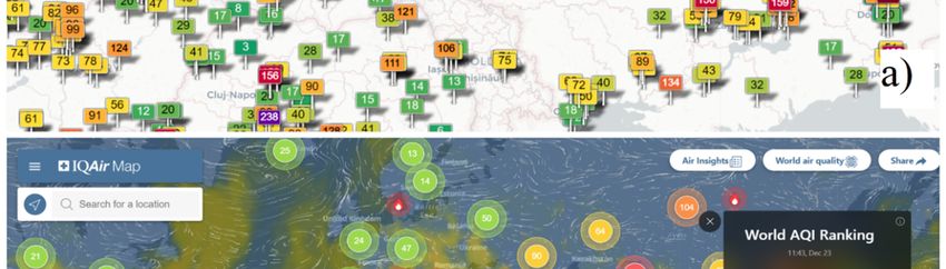
E3S Web of Conferences 280, 09017 (2021) https://doi.org/10.1051/e3sconf/202128009017
ICSF 2021
The aspects of this issue were considered by many According to Directive 2008/50 / EC of the European
well-known scientists. Thus, O.O. Popov, A.V. Iatsyshyn, Parliament and of the Council of 21 May 2008 about air
V.О. Kovach, V.O. Artemchuk, Т.М. Iatsyshyn, quality and cleaner air for Europe [11], the optimal level
А.О. Zaporozhets, V.M. Isaenko, S.M. Majd, J. Burgués, of measurement of pollutants to be considered safe or
S. Marco, A. Arfire, A. Marjovi, A. Martinoli, N. Castell, unsafe for human health the height of 1.5 m above ground
M. Kobernus, H.-Y. Liu, P. Schneider, W. Lahoz, A.J. level is determined, in other words, the average statistical
Berre, J. Noll and others were engaged in solving height of a person. At the same time, for the description,
problems of ecological safety of energy and public modeling and forecasting of pollutant levels in the surface
utilities, but the issue of developing new or improving layer of the atmosphere, the data obtained from a height
existing means to improve the environmental safety of of 1.5 m is not enough, so it is necessary to determine the
man-made areas during emergencies in case of non- highest point of the range of air quality parameters.
radiation pollution of surface air remain relevant and O.G. Shevchenko performed studies [12] of the
important for many developed countries. influence of physical processes potentially caused by the
The study was conducted to analyze the existing influence of the earth's surface on the concentration of
means of monitoring air quality during emergencies in pollutants: sulfur dioxide and nitrogen dioxide, at an
man-made areas and potentially dangerous objects to altitude of 10 to 500 meters above ground level.
develop and implement a more effective means of According to this study, at altitudes of 251-500 m,
operational monitoring of atmospheric air. pollutants that enter the atmosphere from high emission
Within the framework of the aim it is planned to solve sources (enterprise flares) are significantly affected by
the following tasks: meteorological phenomena and changes in the trajectory.
identify the features of the mechanisms of the At altitudes of 10 m to 250 m, low and medium emission
ecological management system of the techno-ecosystem; sources are the main influence.
to analyze pollutants that require special control However, at heights from the direct underlying surface
in the emergency area; (conditionally zero height) to 1.5 m, there is also a
Investigate approaches to the mathematical significant and direct impact of the surface on
description of the movement of pollutants in the ground atmospheric air: erosion of soils, evaporation of water,
layer of the atmosphere; release of pollutants from leaks and exhaust pipes of some
propose the approach to optimize crisis types of vehicles. Most of the substances released in this
monitoring and management of the ground layer of way after entering the atmosphere thus rise to a height of
atmospheric air in areas of emergencies or potential more than 1.5 m and are carried further.
emergencies. Therefore, in accordance with the above, the authors
consider that the ground layer of the atmosphere is the
airspace at altitudes from 1.5 m to 500 m inclusive.
2 Materials and methods
This study was mainly conducted on the basis of domestic 3.2 Features of the impact of emergencies on
and foreign publications on methods of management and technogenically loaded objects on the
monitoring of man-made objects and areas during planned environment
activities and during emergencies, as well as on the basis
The peculiarities of the distribution of pollutants in the air
of the authors of this study.
were described in the 1970-s by M. Berland [13], who
The following research methods were used: method of
determined that the main factors influencing the spread of
comparative analysis, modeling and evaluation of the
impurities in the atmosphere are wind and the distribution
impact of emergencies on the quality of the ground layer
of air temperature with altitude.
of atmospheric air.
Industrial emissions can come from sources of
different heights: from industrial pipes (flares), from
3 The research results sources at ground level, and so on. If the temperature of
the gas released from the source is higher than the ambient
air, the former are characterized by a certain dynamism.
3.1 Ground layer of atmospheric air, features of According to the research of M. Berland, and a group of
definition scientists led by O.O. Popov [14] in the vicinity of the
Nowadays there is no clear definition of the term "ground emission source creates a field of vertical velocities,
layer of the atmosphere" in Ukrainian terminology, so attenuating with distance from the source, which
State standard of technical conditions of Ukraine (DSTU) sometimes extends over long distances and helps to raise
3513-97 “Meteorology: Terms” [10] indicates the surface the impurity up.
layer of the atmosphere as "The lower part of the The process of transferring impurities to the upper
boundary layer of the troposphere, which interacts most atmosphere is called atmospheric stratification and can be
intensely with the underlying surface". In spite of, this defined as the category of stability of the atmosphere.
formulation is not very accurate and does not indicate the The state of the atmosphere can be equilibrium, stable
boundaries of the layer of the atmosphere that is most and unstable. The degree of stability of the atmosphere
affected by the underlying surface, i.e. the habitat of most determines the behavior of the air particle (elementary
living organisms, and in particular humans.
2
E3S Web of Conferences 280, 09017 (2021)                                                          https://doi.org/10.1051/e3sconf/202128009017
ICSF 2021

       volume of air), removed from the original position, in the           the instruments used in the national practice of Ukraine
       upper or lower layer of the atmosphere.                              are often difficult to call modern. This primarily affects
           According to the laws of physics, a particle of warm             the accuracy of measurements and, consequently, the
       air rises and a particle of cold air descends.                       reliability of control over the quality of the environment.
           In the troposphere there is a decrease of temperature            At the same time, when it comes to technical means and
       with increasing altitude, which has a direct impact on the           systems of air pollution control, the most effective,
       "state of the atmosphere". The atmosphere in a particular            accurate, operational are optical, in particular,
       place can be in several different states in their physical           multispectral systems and multisensory systems, that
       characteristics:                                                     allow express and at the same time high-precision control
           1) the state of equilibrium stratification – air particle        of air pollution in selected research ranges.
       moving in a certain direction, takes the temperature of the               Multispectral research devices are imaging devices
       ambient air and its density becomes equal to the density             (image or set of images) in which data are recorded in
       of the surrounding particles, therefore, the cause of its rise       certain wavelength ranges in the electromagnetic
       or fall is leveled;                                                  spectrum [17]. Wavelengths can be separated by optical
           2) the state of stable stratification of the atmosphere –        filters or by sensors sensitive to specific lengths waves,
       if the vertical temperature gradient in the atmosphere is            including light having frequencies outside the visible
       less than at equilibrium, the particle moving up will cool           range, such as infrared and ultraviolet [18]. Spectral
       and will soon become colder than the surrounding air, and            visualization allows you to get additional information that
       heavier than it. Therefore, it will fall and return to its           cannot be seen by the human eye with limited receptors
       original position;                                                   for the vision of blue, green, red. Such tools are usually
           3) the state of unstable stratification – if the vertical        part of geographic information systems that are built on
       temperature gradient is more than equilibrium, the air               the basis of satellites [19].
       particle, starting to move up or down, will continue its                  In contrast, multisensory devices are based on a
       movement with increasing acceleration. The farther it                number of different types of sensors, including optical,
       goes from the initial position, the more its temperature             which allow to obtain a more informative and accurate
       deviates from the ambient temperature [13]. In this case,            conclusion about the quality of atmospheric air in a
       we talk about unstable stratification.                               particular study area.
           Another characteristic of the description of the state of              When the research is performed manually, using any
       the atmosphere is the so-called inversion, which is defined          research tools, there is an error of measurement caused by
       as an increase in temperature with altitude. Temperature             the human factor. Proven accurate remote sensing tools
       inversion can occur both near the earth's surface (surface           should be used to minimize human exposure during
       inversion) and at a certain height (altitude inversion). If          studies that require high accuracy and time.
       the inversion occurs at a certain height above the ground,                Remote means of environmental quality research (Fig.
       it is called elevated. Increased inversion can create                1) can be in the form of meteorological probes, remote
       dangerous conditions for the population living in white              manned or automated robots, unmanned aerial vehicles
       man-made areas, due to the fact that emissions cannot rise           (UAVs) with installed video, infrared cameras and almost
       above a certain level - the "ceiling", the effect of which           any sensors.
       such an inversion creates.                                                The most common remote means of air quality control
           Information on the fundamentals of the functioning of            are state (municipal) systems built on the basis of a set of
       the atmosphere in its various parts is very important for            stationary automatic stations (Fig. 1 a). Such systems have
       determining the qualitative and quantitative indicators of           proven to be the main means of systematic air quality
       air quality at any time, in particular during the operational        monitoring of large cities, suburbs, industrial regions,
       monitoring of air quality in the emergency zone or during            protected areas, etc. They allow to conduct fundamental
       a technogenical accident. It is especially important for             research [20-22] of the patterns of movement and
       forecasting the consequences [14] and effective                      deposition of various pollutants [10], as they have a very
       environmental safety management in areas of such                     high accuracy of equipment, the ability to work around
       situations. For example, it is also important for the                the clock. The main disadvantages of these systems are
       effective assessment and management of the atmosphere                the high cost of placement and operation, stationary, the
       that pollutants enter the atmosphere not only from certain           overwhelming inability to quickly disassemble and move
       stationary or mobile sources of emissions, but can be                the observation station to another location (extremely low
       discharged from the surface of the earth, which has been             mobility).
       man-made and anthropogenic, in particular in Ukraine.                     One of the rather new methods of studying the
       scientists [16] on the territory of Boryspil International           historical levels of air pollution is the method of
       Airport.                                                             dendrochemistry [23], which was considered by a group
                                                                            of Italian scientists led by Edoardo Alterio, who proved
                                                                            the convenience and accuracy of this method of historical
       3.3 Remote atmospheric research tools as the
                                                                            analysis of air quality. Without regard to, this method is
       first and important link in the crisis monitoring
                                                                            not suitable for determining the actual levels of air
       system during emergencies
                                                                            pollution at the time of measurement.
          Unfortunately, modern measuring instruments do not                     The use of small cheap analogues of stationary
       provide enough attention in the scientific community, and            atmospheric air monitoring stations - portable stations - is
                                                                            also quite widespread. Based on a system of municipal

                                                                        3
E3S Web of Conferences 280, 09017 (2021) https://doi.org/10.1051/e3sconf/202128009017
ICSF 2021
(large) and portable cheap (small) stations, there are is calculated [49-50] on the basis of basic measurable
online services (Fig.2.) that disseminate information indicators - dust particles, carbon oxides, nitrogen and
about the relative air quality at a certain point. These sulfur.
relative readings are called the "Air Quality Index", which
Fig. 1. Remote Environmental Monitoring tools [39,45-48].
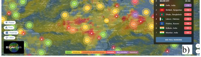
Fig. 2. Examples of online services for information about air quality and air pollution: a) aqicn.org and b) iqair.com.
4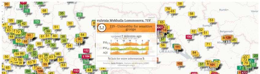
E3S Web of Conferences 280, 09017 (2021)                                                           https://doi.org/10.1051/e3sconf/202128009017
ICSF 2021

           Fig. 3. Effective use of UAVs for manual air quality monitoring [39].

       Fig. 4. Simplified response scheme of the rescue service (SES of Ukraine) to emergencies.

           In the world of rapid development, the use of various             (Italy) [27]. Similar systems are also being tested in
       sensors located in the systems of public, leased and                  several regions of China [26, 28]. Such means of
       private transport to study the parameters of air quality              studying the quality of atmospheric air can be considered
       (Fig.1 b). In particular, A. Arfire, A. Marjovi, A.                   remote, due to the lack of a direct person-performer of
       Martinoli, N. Castell, M. Kobernus, H.-Y. Liu, P.                     measurements, the latter are performed automatically. In
       Schneider, W. Lahoz, A.J. Berre, J. Noll, L. Kang, S.                 some systems, even the sensors are calibrated by a
       Poslad, W. Wang, X. Li, Y. Zhang, C. Wang, G. Lancia,                 measuring device without assistance in an autonomous
       F. Rinaldi, P. Serafini, L. Liu, J. Duan, Z. Xiao, H.P.               automatic mode [25].
       Raju, P. Partheeban, R.R. Hemamalini at al. have their                    Radioacoustic sounding of the atmosphere as a means
       scientific achievements in this field [24-30]. It is based            and method of remote environmental monitoring,
       on the use of the concept of the Internet of Things, to               presented in the works of E.G. Tolstih [31]. This method
       create and group sensor systems that are in some way                  is based on the passive radar spot of scattered
       placed on vehicles and combine them with computer                     electromagnetic oscillations and allows you to remotely
       centers that transmit information about the state of the air          measure such characteristics of atmospheric air as
       in the city to the Internet. Such systems are currently used          humidity, temperature, pressure and other physical
       successfully in cities and regions such as Chennai (India)            indicators of air quality. Notwithstanding, radioacoustic
       [29], Lausanne and Zurich (Switzerland) [24] and Rome                 sounding does not allow to determine the qualitative and

                                                                        5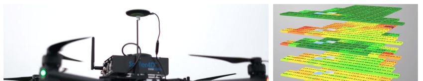
E3S Web of Conferences 280, 09017 (2021)                                                        https://doi.org/10.1051/e3sconf/202128009017
ICSF 2021

       quantitative values of aerosol and dust air pollution, as           hydrogen, carbon monoxide and liquefied petroleum gas
       well as its chemical components in relative and / or                given the turbulence of air generated by UAV propellers
       absolute form - gases, water vapor, etc.                            during its movement and optimize the complex these
           The studies based on the introduction of unmanned               features. The scientists concluded that their system has
       aerial vehicles into active scientific, industrial and public       the highest measurement accuracy only at UAV speeds
       use have become very popular and widespread. At                     up to 6 m/s, and at speeds above this value there is a
       present contemporary UAVs are used: in biology to                   significant decrease in the accuracy of the obtained data.
       explore new, previously inaccessible corners of the
       planet and studied their flora and fauna [32]; in
                                                                           3.4 Legal features of the use of UAVs in the
       emergency services for the introduction of effective
                                                                           system of operational monitoring of the
       means of searching for victims of disasters and
                                                                           atmosphere during emergencies in Ukraine
       emergencies, in particular in the rubble of buildings [33-
       34]; in the fields of marketing and logistics for the               As noted in the previous section, currently unmanned
       development of services of delivery and dissemination of            aerial vehicles have an unsurpassed impact on the speed
       unimpeded provision of the population of remote places              and quality of research in various spheres of life:
       with the necessary means of subsistence [35], in the                economy, industry, science, socio-cultural life.
       military sphere for search and general intelligence [36]                The rapid development of the scope of UAVs has led
       and in the socio-cultural sphere for entertainment and              to the rapid development of interception technologies for
       leisure filming, video-blogging, photo and video                    remote-controlled unmanned aerial vehicles. These
       shooting of sports competitions and concerts [37]. In the           technologies propagate a large number of signals in a
       field of environmental safety, A.O. Zaporozhets,                    certain frequency range, which prevents the exchange of
       J.Burgués, S. Marco, R. Noori and D.P. Dahnil are using             information between the control station and the radio
       UAV-based technologies.                                             transmitter of the aircraft with a radius of several
           The use of UAV-based monitoring systems has found               kilometers, but most modern unmanned aerial vehicles
       its use not only to study air quality, but also to perform          have protection against radio noise and interception.
       research on the reliability of power grids and other energy         Radio interception can be hindered by the use of an
       and infrastructure facilities. [51-53].                             autopilot module in the UAV, with a preset task of the
           Researcher of the Institute of Technical                        desired flight route to the program of the aircraft, which
       Thermophysics of the National Academy of Sciences of                in this case has a mediocre value of data exchange with
       Ukraine A.O. Zaporzhets carried out a research project to           the control station - can transmit real-time images and
       create an air quality monitoring system based on the use            data not used during flight.
       of a set of methods for obtaining information on the state              Anyhow, the use of UAVs for any purpose in Ukraine
       of the atmosphere: UAVs and the existing system of                  is clearly regulated by regulations, in particular: The Air
       planned monitoring based on stationary and mobile air               Code of Ukraine [41]; Regulations on the use of airspace
       quality monitoring posts. In his work, he focused on                of Ukraine [42] and the Rules of use of airspace of
       planned, i.e. continuous monitoring of industrial facilities        Ukraine [43].
       and proposes to study the air for the content of O2, CO,                The State Aviation Service of Ukraine has published
       CO2, NO, NO2, SO2, H2S at an altitude of 50m to 1km                 a map of zones [44] with restrictions on the flight of
       using UAV glider (fig. 1 c) and helicopter types [38].
                                                                           unmanned aerial vehicles. The UAV flight area has a
           Spanish scientists J. Burgués & S. Marco have
                                                                           specific character and is strictly regulated by such
       developed an effective device (Fig. 1 e) for air sampling
                                                                           organizations as the State Agency of Civil Aviation and
       during monitoring of polycopter type UAVs - sniffer
                                                                           the Armed Forces of Ukraine. The result of regulation are
       (sensor unit) of atmospheric quality [39], performing a
                                                                           areas where flights are prohibited in whole or in part
       significant analysis of research conducted today on the
                                                                           limited by the size of the UAV or time of day. In
       location and execution of sniffers for use in unmanned
                                                                           accordance with the requirements of paragraph 4 of
       aerial vehicles during continuous scheduled monitoring
                                                                           section II of the Rules of use of airspace [43], flights of
       of air quality in cities (Fig. 3.). The problem with their
                                                                           unmanned aircraft weighing up to 20 kg inclusive are
       sensor unit is: too dense placement of sensors, which can
                                                                           performed without submitting applications for use of
       affect the work of each other and interfere with the
                                                                           airspace, without obtaining permits for use of airspace,
       uniform blowing of all sensors, as well as the narrow
                                                                           without informing the Air Force of the Armed Forces of
       specialization of the sniffer and the impossibility of its
                                                                           Ukraine and bodies of the joint civil-military system of
       use on various unmanned aerial vehicles, as Burgués, J.,
                                                                           air traffic organization of Ukraine, bodies of the State
       & Marco, S specialized in their invention for use with
                                                                           Border Guard Service of Ukraine, air traffic service
       only three models of helicopters brand DJI
                                                                           bodies and departmental air traffic control bodies, subject
       M100/210/600, as well as on cars.
                                                                           to compliance with certain requirements space".
           Researchers R. Noori & D.P. Dahnil from the
                                                                               Though, emergencies may be defined by Ukrainian
       University of Malaysia Kebangsaan proposed the use of
                                                                           law as force majeure, or endangering the health and well-
       a six-beam polycopter (Fig. 1 d) for use in studies of
                                                                           being of the population, and unmanned vehicles, which
       environmental quality indicators [40]. In their work, they
                                                                           are registered on the balance of the State Emergency
       tried to test the efficiency of the polycopter to determine
                                                                           Service as means of performing special operations to
       the effectiveness of various equipment for measuring the
                                                                           search and eliminate emergencies, their consequences, as
       concentration of four indicators of air quality: smoke,

                                                                       6
E3S Web of Conferences 280, 09017 (2021) https://doi.org/10.1051/e3sconf/202128009017
ICSF 2021
well as for the search for victims, as defined in the Air significantly simplifies and speeds up the work of units
Code of Ukraine, section 4 “use of airspace of Ukraine”, of the SES of Ukraine.
Article 24, paragraphs 1-5 [41].
5 Conclusions
4 Discussion
Emergencies will accompany humanity as long as
After analyzing the above studies, we conclude that the society exists, and therefore it is very important to pay
most promising area of environmental research is the use attention to the sustainable development of the response
of modern remote, including multisensory, means of to emergencies, including environmental ones.
prevention and during emergencies in man-made areas The article considers the features of the study of the
and facilities. surface layer of atmospheric air, reviews the existing
Comprehensive development and implementation of remote means of monitoring the condition of this layer
new remote multisensory and multispectral means and also proposes a new functional scheme of response
technical means of environmental control, taking into of the State Emergency Service of Ukraine to
account the impact of their characteristics and parameters emergencies.
on the effectiveness of the process of controlling ground In order to talk about the monitoring of the surface
air pollution and assessing the ecological state of the layer of atmospheric air, it was necessary to determine
atmosphere of technogenically loaded areas and objects the boundaries of this layer. Based on literary and logical
has the aim of operational monitoring of the quality of theses, the authors of the article determined that the
the ground layer of atmospheric air, reduction of risks to airspace at altitudes from 1.5 m to 500 m inclusive.
health and life of specialists working in the emergency Based on the comparison of different remote means
zone, or one that requires rapid surgical intervention for of environmental air quality monitoring, it can be stated
further localization and elimination. that of all analyzed means, in particular - stationary
Based on the analysis, we propose an improved automatic stations, mobile automatic stations, probes and
scheme (Fig.4) of work of units of the State Emergency unmanned aerial vehicles, it is proposed to use the latter
Service of Ukraine (SESU), which shows two algorithms as a remote means of operational air quality control. time
for responding to an emergency - classic and of emergencies at the enterprise.
recommended. In classical algorithm we distinguish five The proposed functional scheme of implementation
basic steps: of the UAV system for the needs of operational
environmental monitoring of Ukraine will significantly
the first stage is the time from the objective
reduce the response time to emergencies at enterprises,
beginning of the emergency situation, to the moment
although it requires closer relationships "enterprise-unit
when the fact of the emergency is noticed by people;
of the SES of Ukraine" than those that exist now - mostly
the second - starts from the moment of detection
verifiable. The problem of implementing this functional
of emergency and attempt of independent reconnaissance
scheme is the predominant distrust of entrepreneurs to
by non-experts (people nearby) to a call of crew of SESU;
regulatory authorities, which also indicates the need to
the third is the arrival of the rescue service team restructure and reorganize the state emergency service of
and reconnaissance of the scene by specialists, with or Ukraine to strengthen its basic functions to protect the
without special means; population and property of Ukraine from natural and
the fourth is creation of a staff of liquidation of unnatural factors.
emergency situations, development of the plan of Analyzed legal features of the use of unmanned aerial
liquidation, adjustment of structure of crew, etc. vehicles as a remote means of air quality control during
the fifth stage, which is directly to take action to emergencies suggest that the use of UAVs as an
eliminate this emergency. additional means of monitoring air quality in the
The classical algorithm has two main disadvantages. enterprise, as well as its sanitary protection zone is not
The first is the response time, which increases only possible but also easily implemented. the existing
significantly in areas where there are no people, or their regulatory framework of the state.
number is insignificant (for example, land plots of The use of modern means of remote monitoring of
warehouses, landfills, slag dumps, and other objects of environmental quality, including unmanned aerial
man-made origin). The second significant disadvantage vehicles, will make the field of operational (crisis)
is the high risks to life and health of all people in contact monitoring of Ukraine more effective and timely,
with the emergency zone, especially if they do not have compared to the existing system of emergency response,
adequate personal protective equipment against any which could potentially be responsible for environmental
dangerous effects that occur in this area. These two disasters in the region, region, country or even in a cross-
shortcomings are interdependent, as due to the increased border arena. In addition, such optimization will not only
response time, the scale of the emergency increases, and optimize the response time to emergencies, but will also
therefore not only the natural area but also the people be the first link in the whore to develop the scope of rapid
there are more negatively affected. response in the concept of sustainable development.
In contrast to the classical response scheme, the
recommended scheme, provided it is properly
implemented, is as free as possible from the
shortcomings of the classical response scheme, and
7E3S Web of Conferences 280, 09017 (2021) https://doi.org/10.1051/e3sconf/202128009017
ICSF 2021
References oc-page.html?id_doc=69183. (2000) Accessed Nov
28 2020
1. J. Park, et al., Atmospheric Pollution Research,
(2020). doi:10.1016/j.apr.2020.08.010 11. European Union: Directive 2008/50 / EC of the
European Parliament and of the Council of 21 May
2. Y. Zhang, Z. Ding, Q. Xiang, W.Wang, L. Huang & 2008 on ambient air quality and cleaner air for
F. Mao, Short-term effects of ambient PM1 and
Europe.
PM2.5 air pollution on hospital admission for
https://zakon.rada.gov.ua/laws/show/994_950#n340
respiratory diseases: Case-crossover evidence from
Shenzhen, China. Int. J. of Hyg. and Environmental (2008). Accessed Nov 28 2020
Health, (2019). doi: 10.1016/j.ijheh.2019.11.001 12. O.H. Shevchenko, Vplyv inversiy na rivenʹ
3. S. Zangari, D. T. Hill, A. T. Charette & J. E. zabrudnennya atmosfernoho povitrya mista Kyyeva
Mirowsky, Air quality changes in New York City (Influence of inversions on the level of air pollution
during the COVID-19 pandemic. Science of The in Kyiv). Ukr. Hidro-met. J., 8 (2011).
Total Environment, 742 (2020). doi:
10.1016/j.scitotenv.2020.140496 13. M. Berland, Modern problems of atmospher-ic
diffusion and air pollution» (Sovremennyye
4. M. Sarfraz, K. Shehzad & S. G. Meran Shah, The problemy atmosfernoy diffuzii i zagryazneniya
impact of COVID-19 as a necessary evil on air atmosfery), Gidrometeoizdat, 448 (1975).
pollution in India during the lockdown.
Environmental Pollution, (2020). doi: 14. O. Popov, A. Iatsyshyn, V. Kovach, V. Artemchuk,
10.1016/j.envpol.2020.115080 D. Taraduda, V. Sobyna, D. Sokolov, M. Dement,
V.Hurkovskyi, K. Nikolaiev, T. Iatsyshyn, D.
5. A.Tobías, C. Carnerero, C. Reche, J. Massagué, M.
Dimitriieva, Physical Features of Pollutants Spread in
Via, M. C. Minguillón, … X. Querol, Changes in air
quality during the lockdown in Barcelona (Spain) one the Air During the Emergency at NPPs. Nucl. and
month into the SARS-CoV-2 epidemic. Science of Rad. Saf., 4(84), 88-98 (2019). doi:
The Total Environment, (2020). doi: 10.32918/nrs.2019.4(84).11
10.1016/j.scitotenv.2020.138540 15. N.N. Belyaev, T.I. Rusakova, V.E. Kolesnik, A.V.
6. Kabinet Ministriv Ukrainy: Pro zatverdzhennya Pavlichenko, Forecast of the level of atmospheric air
pereliku priorytetnykh tematychnykh napryamiv pollution in the zone of influence of urban highways.
naukovykh doslidzhenʹ i naukovo-tekhnichnykh Scient. Bull. of the Nat. Min. Univ., 1, 90 – 97 (2016).
rozrobok na period do 2020 roku (About the
16. М. Radomska, S. Madzhd, L. Cherniak, O.
statement of the list of priority thematic directions of Mikhyeyev Environmental pollution in the airport
scientific researches and scientific and technical impact area–case study of the Boryspil. Env. Probl.,
developments for the period till 2020). 5 (2), 76–82 (2020).
https://zakon.rada.gov.ua/go/942-2011-%D0%BF
(2011). Accessed Nov 28 2020 17. S. M. Kvaternyuk, Analiz strukturnykh skhem
zasobiv mulʹtyspektralʹnoho televiziynoho
7. Prezydent Ukrainy: Pro Tsili staloho rozvytku vymiryuvalʹnoho kontrolyu parametriv ta
Ukrayiny na period do 2030 roku (On the Sustainable diahnostuvannya stanu neodnoridnykh
Development Goals of Ukraine until 2030). biolohichnykh (Analysis of structural diagrams of
https://zakon.rada.gov.ua/laws/show/722/2019?lang multispectral television measuring control parameters
=en (2019). Accessed 21 Nov 2020
and diagnosing the state of inhomogeneous biological
8. Kabinet Ministriv Ukrainy: Pro skhvalennya media) Opt. elect. inf. energ. techn. J., 1, 54–60
Kontseptsiyi stvorennya zahalʹnoderzhavnoyi (2017). http://nbuv.gov.ua/UJRN/oeiet_2017_1_10
avtomatyzovanoyi systemy “Vidkryte dovkillya” Accessed Nov 28 2020
(About the approval of the Concept of creation of the
national automated system "Open environment"). 18. N. Hagen & M. W. Kudenov, Review of snapshot
https://zakon.rada.gov.ua/laws/show/825-2018- spectral imaging technologies. Optic. Engin., 52 (9),
%D1%80 (2018). Accessed 21 Nov 2020 (2013). doi: 10.1117/1.oe.52.9.090901
9. Horizon Europe. https://ec.europa.eu/info/horizon- 19. Andrii Iatsyshyn, Anna Іatsyshyn, V. Kovach, I.
europe_en (2020). Accessed 21 Nov 2020 Zinovieva, V. Artemchuk, O. Popov, O. Cholyshkina,
Oleksandr Radchenko, Oksana Radchenko, A.
10. Derzhavnyy Standart Ukrayiny (DSTU): 3992-2000 Turevych, Application of Open and Specialized
Klimatolohiya. Terminy ta vyznachennya osnovnykh Geoinformation Systems for Computer Modelling
ponyatʹ(State Standard of Ukraine (DSTU): 3992- Studying by Students and PhD Students. CEUR
2000 Climatology. Terms and definitions of basic Workshop Proceedings 2732, 893-908. http://ceur-
concepts).http://online.budstandart.com/ua/catalog/d ws.org/Vol-2732/20200893.pdf (2020).
8E3S Web of Conferences 280, 09017 (2021) https://doi.org/10.1051/e3sconf/202128009017
ICSF 2021
20. Kirchner, M., Freier, K. P., Denner, M., Ratz, G., Sensors and Internet. Int. J. of Env. Sc, & Dev., 3 (4),
Jakobi, G., Körner, W., … Moche, W. Air 323–327 (2012). doi: 10.7763/IJESD.2012.V3.240
concentrations and deposition of chlorinated dioxins
and furans (PCDD/F) at three high alpine monitoring 30. Y. Huang, W. Mok, Y. Yam, J. L. Zhou, N. C.
stations: Trends and dependence on air masses. Surawski, B. Organ, … H. C. Ong, Evaluating in-use
Atmospheric Environment, vehicle emissions using air quality monitoring
(2019). doi:10.1016/j.atmosenv.2019.117199 stations and on-road remote sensing systems. J. Sc. of
The Tot. Env.,
21. Ma, J., Li, Z., Cheng, J. C. P., Ding, Y., Lin, C., & (2020). doi:10.1016/j.scitotenv.2020.139868
Xu, Z. (2019). Air quality prediction at new stations
using spatially transferred bi-directional long short- 31. E.G. Tolstykh, Improvement of models and methods
term memory network. Science of The Total of radioacoustic sounding of the atmosphere.
Environment, Dissertation. National University of Radio
135771. doi:10.1016/j.scitotenv.2019.135771 Electronics (Kharkiv), 2018.
22. I. Hůnová, V. Bäumelt and M. Modlík, Long-term 32. C.L. Wood, S.H. Sokolow, I.J. Jones, A.J. Chamberl
trends in nitrogen oxides at different types of in, K.D. Lafferty, at al., Precision mapping of snail
monitoring stations in the Czech Republic, Science of habitat provides a powerful indicator of human
the Total Environment (2019), schistosomiasis transmission/ / Proc. of the Nat. Ac.
https://doi.org/10.1016/j.scitotenv.2019.134378 of Sc., 116 (46), (2019). doi:
10.1073/pnas.1903698116
23. Alterio, E., Cocozza, C., Chirici, G., Rizzi, A., &
Sitzia, T. (2020). Preserving air pollution forest 33. K. Smetanin, Osoblyvosti vykorystannya
archives accessible through dendrochemistry. Journal bezpilotnykh litalʹnykh aparativ v ekolohichnomu
of Environmental Management, 264, monitorynhu. Systemy upravlinnya, navihatsiyi ta
(2020). doi:10.1016/j.jenvman.2020.110462 zvʺyazku (Features of the use of unmanned aerial
vehicles in environmental monitoring). Contr., navig,
24. Arfire A. Marjovi A., Martinoli A.Enhancing and com. syst. J., 3 (49), 22-25 (2018). doi:
Measurement Quality Through Active Sampling In 10.26906/SUNZ.2018.3.022
Mobile Air Quality Monitoring Sensor Networks.
Proceedings of the IEEE International Conference on 34. V. O. Sekret, Vykorystannya kompleksiv BPLA
Advanced Intelligent Mechatronics (Banff, Alberta, pidrozdilamy DSNS. Nauka pro cevyl`nyj zaxyst yak
Canada, July 12–15, 2016), 313–321,(2016). shlyax stannovlennya molodyx vchenyx (Use of
https://doi.org/10.1109/AIM.2016.7576904 UAV complexes by SES units. The science of evil
protection as a way of becoming young scientists).
25. Castell N., Kobernus M., Liu H.-Y., Schneider P., 119 (2019).
Lahoz W., Berre A.J., Noll J. Mobile technologies
and services for environmental monitoring: The Citi- 35. В.Moroz, А. Antipov & V. Zhuravlev
Sense-MOB approach. Urban Climate, 14(3), 370– Avtomatyzovana systema dostavky medykamentiv za
382 (2015). dopomohoyu bezpilotnyx lital"nyx aparativ
https://doi.org/10.1016/j.uclim.2014.08.002 (mul"tykopteriv) za zapytom
26. і3 Kang L. Poslad S., Wang W., Li X., Zhang Y., spozhyvacha(Automated system of drug delivery by
Wang C. A Public Transport Bus as a Flexible Mobile means of unmanned aerial vehicles (silt polycopters)
Smart Environment Sensing Platform for IoT. at the request of the consumer). J. comp.-integr.
Proceedings of the 2016 12th International techn.: educ., sc., prod., 35, 47-54 (2019).
Conference on Intelligent Environments (London,
UK, September 14-16, 2016). 1–8 (2016). 36. V. Hlotov, A. Hunina & Yu. Teleshhuk, Analiz
https://doi.org/10.1109/IE.2016.10 mozhlyvostej zastosuvannya bezpilotnyx lital"nyx
aparativ dlya vijs"kovyx cilej(Analysis of the
27. Lancia G. Rinaldi F., Serafini P. A Facility Location possibilities of using unmanned aerial vehicles for
Model for Air Pollution Detection. Mathematical axle casing purposes). Suchasni dosyahnennya
Problems in Engineering. 1–8 (2018).
heodezychnoyi nauky ta vyrobnyctva, 1, 139-146
https://doi.org/10.1155/2018/1683249
(2017).
28. Liu L. Duan J., Xiao Z., Wang C., Li X. A Fault-
Tolerant Mobile Sensing Information Gathering 37. M. A. Mykytyuk, Rol` ta misce bezpilotnyx lital`nyx
Center (MSIGC) Using Public Transport Buses to aparativ pry zabezpechenni bezpeky osib pid chas
Instrument a Smart City. Proceedings of the 2017 9th provedennya masovyx zaxodiv(The role and place of
International Conference on Advanced Infocomm unmanned aerial vehicles in ensuring the safety of
Technology. 233–238 (2017). persons during mass events). Scientific Notes of Lviv
https://doi.org/10.1109/ICAIT.2017.8388921 University of Business and Law ,18, 41-47 (2017).
29. Raju H.P., Partheeban P., Hemamalini R.R. Urban 38. A. O. Zaporozhets, Analysis of means for monitoring
Mobile Air Quality Monitoring Using GIS, GPS, air pollution in the environmental. Naukoyemni
9E3S Web of Conferences 280, 09017 (2021) https://doi.org/10.1051/e3sconf/202128009017
ICSF 2021
tekhnolohiyi, 3 (35) (2017). doi: 10.18372/2310- tasks of sustainable development of environmental
5461.35.11844 problems: peculiarities of programming and
implementation in the specialists’ preparation. E3S
39. J. Burgués & S. Marco, Environmental chemical Web Conf. 166, 01001 (2020).
sensing using small drones: A review. Science of The doi:10.1051/e3sconf/202016601001
Total Environment. (2020). doi:
10.1016/j.scitotenv.2020.141172 51. A.O. Zaporozhets, V.V. Khaidurov, Mathematical
Models of Inverse Problems for Finding the Main
40. R. Noori, D.P. Dahnil, The effects of speed and Characteristics of Air Pollution Sources. Water Air
altitude on wireless air pollution measurements using Soil Pollut. 231, 563 (2020). doi:10.1007/s11270-
hexacopter drone. Int. J. of Adv. Comp. Sci. and App- 020-04933-z
ns, 11 (2020).
52. V. Zaporozhets, V. Babak, at al. Analysis of the Air
41. Povitryanyj kodeks Ukrayiny: Kodeks Pollution Monitoring System in Ukraine, in Studies in
Ukrayiny (Air Code of Ukraine: Code of Ukraine), Systems, Decision and Control Systems, 298, 85-110
https://zakon.rada.gov.ua/go/3393-17 (2011). ed. by V. Babak, V. Isaienko, A. Zaporozhets
Accessed Nov 28 2020 (Springer, Cham, 2020). doi:10.1007/978-3-030-
48583-2_6
42. Kabinet Ministriv Ukrainy: Pro zatverdzhennya
Polozhennya pro vykorystannya povitryanoho 53. A. Zaporozhets, Overview of Quadrocopters for
prostoru Ukrayiny (On approval of the Regulations Energy and Ecological Monitoring, in Studies in
on the use of airspace of Ukraine) Systems, Decision and Control Systems, 298, 15-36,
https://zakon.rada.gov.ua/go/954-2017-%D0%BF ed. by V. Babak, V. Isaienko, A. Zaporozhets
(2017) Accessed Nov 28 2020 (Springer, Cham, 2020). doi:10.1007/978-3-030-
48583-2_2
43. Derzhaviasluzhba Ukrayiny: Pro zatverdzhennya
Aviatsiynykh pravyl Ukrayiny «Pravyla
vykorystannya povitryanoho prostoru Ukrayiny»
(State Aviation Service of Ukraine: On approval of
the Aviation Rules of Ukraine "Rules for the use of
airspace of
Ukraine").URL:https://zakon.rada.gov.ua/go/z1056-
18 (2018).Accessed Nov 28 2020
44. Derzhavna aviacijna sluzhba Ukrayiny: Zony
zaboron ta obmezhen" vykorystannya povitryanoho
prostoru. https://avia.gov.ua/bezpilotni-povitryani-
sudna-2/zoni-zaboron-ta-obmezhen-vikoristannya-
povitryanogo-prostoru/(2018). Accessed 28 Nov
2020
45. Virazh aero photogallery
http://uav.nau.edu.ua/fotom10.html Accessed Dec 05
2020
46. Ambient Air Monitoring Network Review.
https://content.govdelivery.com/accounts/MIDEQ/b
ulletins/1f1e994 Accessed Dec 05 2020
47. Environment: Air Pollution and Public Fleet
Management.
https://www.energyiot.co.th/applications Accessed
Dec 05 2020
48. DJI Matrice M600. www.dji.com/matrice600
Accessed Dec 05 2020
49. O. Popov, A. Iatsyshyn, V. Kovach, V. Artemchuk, I.
Kameneva, D. Taraduda, V. Sobyna, D. Sokolov, M.
Dement, T. Iatsyshyn, Risk assessment for the
population of Kyiv, Ukraine as a result of atmospheric
air pollution. J. Health Pollut. 10, 200303 (2020).
doi:10.5696/2156-9614-10.25.200303
50. A. Iatsyshyn, A. Iatsyshyn, V. Artemchuk, I.
Kameneva, V. Kovach, O. Popov, Software tools for
10You can also read