Developments in Modern GNSS and Its Impact on Autonomous Vehicle Architectures
←
→
Page content transcription
If your browser does not render page correctly, please read the page content below
Developments in Modern GNSS
and Its Impact on
Autonomous Vehicle Architectures
Niels Joubert, Tyler G. R. Reid, and Fergus Noble
Abstract— This paper surveys a number of recent develop-
ments in modern Global Navigation Satellite Systems (GNSS)
and investigates the possible impact on autonomous driving
arXiv:2002.00339v1 [cs.RO] 2 Feb 2020
architectures. Modern GNSS now consist of four independent
global satellite constellations delivering modernized signals at
multiple civil frequencies. New ground monitoring infrastruc-
ture, mathematical models, and internet services correct for
errors in the GNSS signals at continent scale. Mass-market
automotive-grade receiver chipsets are available at low Cost,
Size, Weight, and Power (CSWaP). The result is that GNSS in
2020 delivers better than lane-level accurate localization with
99.99999% integrity guarantees at over 95% availability. In
autonomous driving, SAE Level 2 partially autonomous vehicles
are now available to consumers, capable of autonomously
following lanes and performing basic maneuvers under human
supervision. Furthermore, the first pilot programs of SAE Level
4 driverless vehicles are being demonstrated on public roads.
However, autonomous driving is not a solved problem. GNSS
can help. Specifically, incorporating high-integrity GNSS lane
determination into vision-based architectures can unlock lane-
level maneuvers and provide oversight to guarantee safety.
Incorporating precision GNSS into LiDAR-based systems can
unlock robustness and additional fallbacks for safety and util-
ity. Lastly, GNSS provides interoperability through consistent
timing and reference frames for future V2X scenarios.
I. I NTRODUCTION
Localization is a foundational capability of autonomous
driving architectures. Knowledge of precise vehicle loca-
tion, coupled with highly detailed maps (often called High
Definition (HD) maps), add the context needed to drive
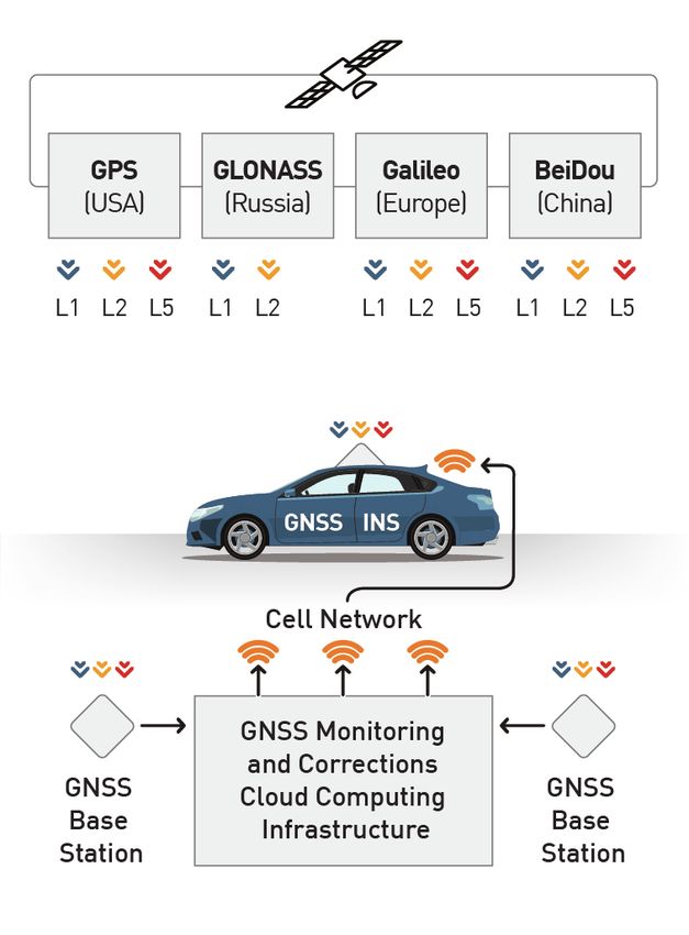
with confidence. To maintain the vehicle within its lane, Fig. 1. The modern GNSS automotive ecosystem. Vehicles equipped with
automotive-grade low CSWaP hardware receives signals from four satellite
highway operation requires knowledge of location at 0.50 constellations across three bands. Sparse ground station network backed by
meters whereas local city roads require 0.30 meters [1]. cloud computing provide error corrections and fault monitoring, delivered
The challenge facing auto makers is meeting reliability at using standardized protocols via cellular networks.
an allowable failure rate of once in a billion miles for
Automotive Safety Integrity Level (ASIL) D [2]. Achieving
this for autonomous vehicles has not yet been demonstrated. driving decisions. Unfortunately, purely perception-based
There are six levels (0 to 5) of autonomous driving as approaches struggle to fully solve the driving problem due
defined by the Society of Automotive Engineers (SAE) [3]. to outages from environmental effects, faults from sensor
Here, we explore current autonomous vehicle architectures glitches, and ambiguities in the real world. For instance,
for driver-supervised partial autonomy (SAE Level 2), and Google (Waymo) famously demonstrated the challenge of
driverless operation in a restricted operating domain (SAE correctly interpreting an upside-down stop sign sticking out
Level 4). Both approaches rely on perception sensors to of the backpack of a cyclist [4]. The industry has looked
understand the environment in which the vehicle must make toward robust localization systems and detailed maps to
address these challenges.
Niels Joubert and Fergus Noble are with Swift Navigation, GNSS and automated driving have a long lineage. Both
San Francisco, CA 94103, email: njoubert@gmail.com, have seen revolution. Early GNSS suffered from low accu-
fergus@swift-nav.com
Tyler G.R. Reid is with Xona Space Systems, Vancouver, BC, email: racy, limited availability, and a lack of integrity. Still, the
tyreid@alumni.stanford.edu ability to globally localize to a map was already valuableenough that contenders in the 2005-2007 DARPA Chal- continuous global service in 2011 [8]. China’s BeiDou-3
lenges [5] used GNSS, but only for road-level routing. Since operationalized 19 satellites starting in 2012, with the full
then, GNSS experienced a step-change in performance and 24 satellite constellation targeted for operational readiness
capabilities thanks to the development of the ecosystem by the end 2020 [9]. The European Union’s Galileo system
shown in Figure 1. Simultaneously, autonomous driving operationalized 22 satellites starting in 2013 with an intended
has moved from a science experiment to driver-supervised 24 satellites plus 6 spares expected to be completed by the
consumer products and early driverless pilot programs. Yet end of 2020 [10]. There are already more than 1 billion
reaching the safety, comfort, cost and utility levels required Galileo-enabled devices in service. In addition to the four
for widespread adoption of autonomous driving have proved global systems, there are multiple regional systems coming
slow and elusive. In this paper, we explore the potential role online including Japan’s 4-satellite Quazi-Zenith Satellite
of a modern GNSS in achieving the ultimate autonomous System (QZSS) and India’s 7-satellite Navigation with Indian
driving safety goal of only one localization failure per billion Constellation (NAVIC). QZSS is particularly interesting,
miles per vehicle. since it is designed to provide coverage in dense urban areas,
and transmits correction information to improve accuracy and
II. R ECENT D EVELOPMENTS IN M ODERN GNSS
provide basic integrity monitoring for GNSS [11].
In the last 20 years, key areas of development in modern Most GNSS techniques work with as few as 5 satellites.
GNSS have progressed performance to the point where Soon most users will have over 25 satellites above the
decimeter-level accuracy with over 95% availability is avail- horizon at all times. This redundancy is important for a
able for automotive. Furthermore, these developments have number of reasons. The large number of satellites increases
unlocked integrity capabilities — the ability of the receiver GNSS availability, since local obstructions can now block
to provide a trustworthy alert when it cannot guarantee the significant parts of the sky without preventing GNSS func-
validity of its outputs to an extremely high probability [6]. tionality. Indeed, Heng et al. demonstrated that a three-
We now survey seven key areas of development. constellation system that can only see satellites more than
A. Multiple Independent GNSS Constellations 32 degrees above the horizon is equivalent in performance
to a GPS-only constellation in an open-sky environment [12].
Furthermore, these satellite navigation systems are indepen-
150 dently developed and operated, enabling integrity guarantees
No. of GNSS Satellites in Orbit
through cross-checking between constellations.
B. Modern Signals Across Multiple Frequencies
125
New GNSS satellites broadcast modernized signals on
multiple civil frequencies. GPS, GLONASS, Galileo, Bei-
100 Dou, and QZSS all operate in the legacy L1 / E1 / B1C
band (around 1575.42 MHz). Further, all also operate or
have plans to operate in the modernized L5 / E5a / B2a band
75 (around 1176.45 MHz) [13]–[17]. GPS and GLONASS also
operate in the L2 band (around 1227.6 MHz).
The L5 band offers tenfold more bandwidth than the L1
50 signal. Modern GNSS signals use the additional bandwidth
2012 2014 2016 2018 2020 to offer up to an order of magnitude better satellite ranging
precision, improved performance in multi-path environments,
Year protection against narrowband interference, and speeding up
signal acquisition from 2 seconds to 200 milliseconds [18],
[19]. Furthermore, the L5 band is reserved for safety-of-
Fig. 2. Number of GNSS satellites in orbit as a function of time. In 2005, life applications, enabling strict regulations against radio
GPS-only receivers had access to less than 30 satellites, while modern GNSS
receivers have access to over 125. frequency interference. This is helpful, since several devices
in the autonomous vehicle world have been known to cause
The U.S. GPS was declared fully operational in 1995 with interference including USB 3.0 connections with L2. Figure
24 satellites providing global coverage, and opened for civil 3 shows the progress in the number of multi-frequency
use in 2000. At that time, accuracy was around 10 meters [7]. satellites available.
Since then, three new global satellite navigation systems
have been put into service by other nation-states, with more C. Error Correction Algorithms for High Precision GNSS
than 125 navigation satellites operational as of 2020. The The accuracy of standard GNSS is degraded due to noise
progression is shown in Figure 2, highlighting that most of and biases in the satellite orbits and clocks, hardware,
this increase happened since 2016. atmospheric conditions, and other effects. Similarly, standard
Russia’s GLONASS was the second GNSS constellation GNSS has no provisions to protect against faults. High
to reach operational status, gaining market adoption and precision GNSS deploy error correction and fault detection140
L1 to PPP, it uses a network of ground stations to estimate
L1 + L2 errors directly. Similar to RTK, it solves the integer ambigu-
120 L1 + L5
ity problem to find centimeter-accurate ranges to satellites.
100 This approach has recently been shown as viable with
Number of Satellites
>150 km spacing between GNSS base stations [23]. PPP-
80 RTK is attractive since this approach can scale corrections to
continent-level seamlessly without the challenges of an RTK
60 approach, and can achieve meter-level protection levels with
formal guarantees on integrity to the level of 10-7 probability
40 of failure per hour or a reliability of 99.99999% [24].
20
D. Ground-based GNSS Monitoring Networks
0 Calculating corrections and performing fault detection
2004 2006 2008 2010 2012 2014 2016 2018 2020
Year requires ground monitoring networks. Several players are
now deploying large-scale correction services targeted at
Fig. 3. L1 (E1, B1C), L2, and L5 (E5a, B2a) civil signals as function of automotive applications in North America and Europe in-
time. Today, more than half of GNSS satellites transmit on multiple bands.
cluding Hexagon [25], Sapcorda [26], Swift Navigation [27],
Trimble [28], in China with players like Qianxun [29], and in
Japan with the state-sponsored QZSS service for automated
algorithms to provide up to centimeter-level accuracy and in-
driving [30]. These networks often deploy PPP-RTK style
tegrity guarantees. Table I shows the three major techniques
approaches that additionally include specialized integrity
employed in achieving GNSS precision: RTK, PPP, and the
monitoring solutions [27], [31].
hybrid PPP-RTK.
The Real-Time Kinematic (RTK) method calculates a cen-
timeter accurate baseline to a local static reference receiver E. GNSS Corrections Data Standardization
by differencing the received signals between both receivers.
Corrections data have to be delivered to receivers in an
Differencing cancels common mode signals, producing an
understandable format. Demand from the automotive and
accurate 3D vector between the static and roving receiver as
cellular industries is leading to interoperability between
long as the two receivers are within a few dozen kilometers.
networks and devices [26], [32], driving standardization of
This approach resolves what is known as the carrier phase
corrections data. Most relevant to the automotive community,
integer ambiguity. Performing integer ambiguity resolution
The 3rd Generation Partnership Project (3GPP) is integrating
allows using only the carrier phase of the GNSS signal
GNSS corrections data directly into the control plane of the
for positioning, which provides centimeter accurate satellite
5G cellular data network [33]. This integration allows broad-
ranging. RTK provides the highest accuracy of precision
casting standardized corrections data to all vehicles simulta-
methods, but requires a dense monitoring network to cover
neous for lower cost, higher reliable, and better scalability
a large area, complex handoff procedures between base sta-
than point-to-point connections. A variant of this approach is
tions [20], and does not natively provide integrity guarantees.
also available as the Centimeter Level Augmentation Service
TABLE I (CLAS) broadcast from the QZSS satellites in over Japan.
E RROR C ORRECTION APPROACHES FOR GNSS. Interoperability and standardization enables the globalization
of high-accuracy high-integrity positioning networks as a
PPP RTK PPP-RTK service.
Accuracy 0.30 m 0.02 m 0.10 m
Convergence Time >10 minutes 20 seconds 20 seconds
Coverage Global Regional Continental
F. New Geodetic Datums & Earth Crustal Models
Seamless Yes No Yes
A challenge facing precision applications is the constant
movement of the Earth’s crust. In California’s coast, tectonic
The Precise Point Positioning (PPP) [21] technique cor- shift is as much as 0.10 m a year laterally [34]. Tidal forces
rects individual errors by utilizing precise orbit and clock due to the Moon and Sun deform the Earth’s surface by as
corrections, estimated from less thas 100 global reference much as 0.40 m over six hours [35]. The weight of ocean
receivers. This technique scales globally, but requires the tides can result in a further 0.10 m of deformation [35].
receiver to estimate the atmospheric errors slowly over time, High accuracy reference frames for maps and GNSS must
taking many minutes to converge. PPP approaches do not use account for these effects. Fortunately, the modern ITRF2014
carrier-only ranging, and are typically limited to decimeter and ITRF2020 [36] datums and services such as NOAA’s
accuracy for automotive. Horizontal Time-Dependent Positioning [37] can do so,
Modern GNSS has developed the hybrid PPP-RTK method keeping maps and GNSS localization consistent for decades
to overcome the limitations of PPP and RTK [22]. Similar even across continents.G. Mass-Market Automotive GNSS Chipsets Following the methodology presented in [1], it can be The improvements in GNSS satellites is only bene- shown that the lateral position error budget for highway lane ficial if capable and affordable receiver hardware ex- determination is 1.62 m for passenger vehicles in the U.S. ists. Fortunately, multi-frequency, multi-constellation mass- For safe operation, it is recommended by [1] that this position market ASIL-certified GNSS chipsets are now available. protect level be maintained to an integrity risk of 10-8 / h, Automotive-grade dual-frequency receivers were first show- or a reliability of 5.73σ assuming a Gaussian distribution of cased in 2018 [38] delivering decimeter positioning [39]. errors. This gives us the following relationship: Major players in this space now include STMicroelectronics with its Teseo APP and Teseo V [38], u-blox with its F9 [40], 5.73 σtotal < 1.62 m (2) and Qualcomm with its Snapdragon [41]. The CSWaP of solving for σtotal gives: these units are mostly
TABLE II
                  S ELECT DATA POINTS THAT SHOW ON - ROAD GNSS PERFORMANCE IMPROVEMENTS BETWEEN 2000-2019.

              Year                                                 GNSS
                                                       Receiver                                                             Outage
   Source      of       Data Set    Const.    Freq.                Correc-         Env.       Accuracy     Availability
                                                        Type                                                                Times
              Data                                                  tions

                                                                                             10m, 74%,                     4.7 min,
     [7]      2000      2 hours      GPS       L1      Survey        None         Urban                       28%
                                                                                               Lateral                    Worst-Case
                                                                                  Urban,                    85%, Code     28 sec, 95%,
                       186 hours                                                 Suburban,                    Phase        Code Phase
    [42]      2010                   GPS       L1      Survey        None                         -
                      (13,000 km)                                                 Rural,                     Position       Position
                                                                                 Highway                   (HDOP > 3)     (HDOP > 3)
                                    GPS,
                                                       Mass                                  0.77m, 95%,
    [39]      2017       1 hour     GLO,     L1, L2               Proprietary    Suburban                       -              -
                                                       Market                                 Horizontal
                                     Gal
                                                                                                           50% Integer    10 sec, 50%,
                       355 hours    GPS,                                          Mostly     1.05m, 95%,
    [43]      2018                           L1, L2    Survey     Net. RTK                                  Ambiguity     40 sec, 80%
                      (30,000 km)   GLO                                          Highway      Horizontal
                                                                                                             Fixed           Fixed
                                                                                                           87% Integer
                                    GPS,              Research                               0.14m, 95%,                  2 sec, 99%,
    [44]      2019      2 hours              L1, L2               Net. RTK        Urban                     Ambiguity
                                    Gal                SDR                                    Horizontal                     Fixed
                                                                                                             Fixed
                                                                  Proprietary,
   Swift                12 hours    GPS,                Mid-                      Mostly     0.35m, 95%,      95%
              2019                           L1, L2               Continent-                                                   -
 Navigation            (1,312 km)   Gal                 Range                    Highway      Horizontal    CDGNSS
                                                                     Scale

A. SAE Level 2 Vision-based Systems                               B. SAE Level 4 LiDAR-based systems

                                                                     Level 4 systems under development intend to fully auto-
   An archetypal Level 2 architecture for autonomous lane-        mate the dynamic driving tasks within its ODD, with no vehi-
following under human supervision is shown in Figure 4.           cle operator required. The archetypal architecture for Level
Perception is used for in-lane control to keep the vehicle be-    4 driving is given in Figure 5. One of the insights shared
tween lane lines without aid from maps and localization [51].     by most Level 4 systems is to simplify the driving problem
State-of-the-art Level 2 systems aim to move beyond lane-         through high accuracy maps and localization. Indeed, most
following and provide onramp-to-offramp freeway naviga-           Level 4 systems cannot function if the localization or map-
tion, which requires selecting and changing into the correct      ping subsystem is unavailable, and localization failures often
lanes to traverse interchanges and merges and selecting or        trigger an emergency stop.
avoid exit lanes. This functionality was first demonstrated by       Level 4 architectures have historically relied on LiDAR
Tesla’s ‘navigate on autopilot’ feature using computer vision     for localization, achieving < 0.10 m, 95% lateral and
and radar [52], [53]. The Cadillac Super Cruise approach          longitudinal positioning accuracy [56]. LiDAR localization
also utilizes computer vision and radar, but further employs      approaches can leverage 3D structure [57] and surface re-
precision GNSS and HD maps to (1) geofence the system             flectivity [58]–[60]. GNSS is not the primary localization
to limited access divided highways and (2) provide extended       sensor due in part to historical availability challenges [61].
situational awareness beyond perception range [54], [55].         Unfortunately, LiDAR also suffers from outages, faults, and
   The dependency of these Level 2 architectures on camera        erroneous position outputs, especially during adverse weather
data leads to three major challenges. One, ambiguous road         or in open featureless environments such as highways [62]–
markings can lead such systems astray, steering vehicles into     [66]. Inertial and odometry-based navigation is commonly
phantom lanes and potentially causing fatal accidents. Two,       used in conjunction with LiDAR to address some of these
for lane-level maneuvers such as lane changes, navigating in-     concerns, but suffer from position drift over time. An ad-
terchanges and merges, and choosing or avoiding exit lanes,       ditional absolute localization sensor would aid in providing
the vehicle has to correctly infer its surrounding lanes and      redundancy to overcome outages and detect LiDAR errors
read, associate, and remember road signs to understand the        and faults.
lane’s intended use. Lastly, these systems have no fallback in       Precision GNSS is complementary to LiDAR. GNSS’
the face of environmental effects that can degrade, occlude       microwave signals are unaffected by rain, snow, and fog.
or damage cameras. These challenges makes it difficult to         GNSS also performs best in open sparse environments like
reach the reliability required for safety-of-life deployment.     highways. For these reason, precision GNSS can aid LiDAR-
Precision GNSS providing lane-level localization and lane         based localization to reach safety-of-life levels of reliability
determination, coupled with HD Maps, can address each of          and coverage. One example of a Level 4 system that lever-
these challenges.                                                 ages precision GNSS is Baidu’s Apollo framework [67].
Fig. 5. Common elements of SAE Level 4 automated driving architectures.
Fig. 4. Common elements of traditional SAE Level 2 automated driv- Sensor data flows from LiDAR, cameras, RADAR, IMUs, GNSS and others
ing architectures for lane-following. A perception system provides lateral to both the localization and perception system. The localization system
and longitudinal in-lane localization and detects surrounding vehicles. A tracks the vehicle’s pose by fusing relative motion from inertial, wheel,
dedicated localization and mapping system provides oversight over the and possibly radar data with map-relative localization. The localization
perception system and enables planning beyond perception limits, such and mapping system provides enough fidelity to solve the driving problem
as slowing for upcoming curves. The desire to perform more complex in static environments, freeing perception system to focus on detecting
maneuvers such as lane changes is evolving this architecture towards dynamics in the environment, such as moving actors, traffic light states,
unifying precision GNSS for lane-level localization and camera-based in- and roadwork. A representation of the environment containing both the
lane localization to plan and execute paths. surrounding static map from localization and the dynamic elements from
perception is passed to motion planning, which hierarchically solves for the
path the vehicle will follow.
V. D ISCUSSION
We have hinted at the potential benefits of GNSS given C. Providing Safety Through Independence
the current localization challenges for autonomous driving
The challenge facing automakers is meeting the required
architectures. We discuss each benefit here.
level of reliability at 99.999999% [1] to prove system safety.
A. Unlocking Lane-Level Maneuvers This allowable failure rate of once in a billion miles repre-
sents ASIL D, the strictest in automotive [2]. One powerful
We have shown that GNSS can provide lane determina-
method to reach this level of reliability is combining inde-
tion with safety-of-life level integrity, especially valuable to
pendent systems to redundantly localize the vehicle. GNSS
Level 2 vision-based systems given their challenges outlined
can provide this independent signal.
previously. Lane determination on an HD map enables plan-
ning lane-level maneuvers with confidence, providing a key
D. Fallback During Outages
building block for safe onramp-to-offramp navigation.
Both LiDAR and vision systems experience outages. Level
B. Providing Oversight over Vision Systems 4 systems rely on expensive tactical-grade Inertial Measure-
Vision systems can be fooled into detecting phantom ment Units (IMU) to safely pull over in these circumstances,
lanes leading to extremely hazardous behavior. GNSS lane and Level 2 systems depend on the driver to intervene.
determination provides an independent signal to verify the Precision GNSS might be a viable fallback during outages,
validity of vision outputs. enabling operation in a degraded mode for Level 4 systemsand aiding in advanced warning of a required driver inter- [14] European Union, “European GNSS (Galileo) Open Service Signal
vention to transform Level 2 systems into Level 3 systems. In Space Interface Control Document,” European Union, Tech. Rep.,
2015.
[15] China Satellite Navigation Office, “BeiDou Navigation Satellite Sys-
E. Unlocking Interoperability to Overcome Occlusion and tem Signal In Space Interface Control Document Open Service Signals
Enable Collaboration B1C and B2a (Test Version),” China Satellite Navigation Office, Tech.
Rep., 2017.
An important future opportunity is interopreability be- [16] Cabinet Office (Government of Japan), “Quasi-Zenith Satellite System
tween autonomous systems, which cannot be understated. Interface Specification Centimeter Level Augmentation Service (IS-
For one, information sharing between vehicles and static QZSS-L6-001),” Tech. Rep., 2018.
[17] M. Lu, W. Li, Z. Yao, and X. Cui, “Overview of BDS III new signals,”
infrastructure is a powerful approach to overcoming percep- Navigation, Journal of the Institute of Navigation, vol. 66, no. 1, pp.
tual sensor occlusion — a major challenge for autonomous 19–35, mar 2019.
vehicles. Furthermore, interoperability enables strategic and [18] C. J. Hegarty and E. Chatre, “Evolution of the Global Navigation
Satellite System (GNSS),” Proceedings of the IEEE, vol. 96, no. 12,
tactical collaboration, augmenting basic driving to unlock pp. 1902–1917, 2008.
coordination between vehicles and commodifying enabling [19] M. Tran, “Performance evaluations of the new GPS L5 and L2 Civil
technologies such as HD Maps. Interoperability requires (L2C) signals,” Navigation, Journal of the Institute of Navigation,
vol. 51, no. 3, pp. 199–212, 2004.
sharing common spatial reference frames and timing. The [20] M. J. Murrian, C. W. Gonzalez, T. E. Humphreys, and T. D. Novlan,
obvious choice for a global standard is that defined by “A dense reference network for mass-market centimeter-accurate po-
GNSS, namely, the ITRF datum and GPS global time. GNSS sitioning,” in Proceedings of the IEEE/ION Position, Location and
Navigation Symposium, PLANS 2016, 2016, pp. 243–254.
offers the only source of globally consistent precise position
[21] J. Kouba and P. Héroux, “Precise Point Positioning Using IGS Orbit
and time to act as a standard reference for all autonomous and Clock Products,” GPS Solutions, vol. 5, no. 2, pp. 12–28, oct
systems. 2001.
[22] G. Wübbena, M. Schmitz, and A. Bagge, “PPP-RTK: Precise Point
R EFERENCES Positioning using state-space representation in RTK networks,” Pro-
ceedings of the 18th International Technical Meeting of the Satellite
[1] T. G. R. Reid, S. E. Houts, R. Cammarata, G. Mills, S. Agarwal, Division of The Institute of Navigation, ION GNSS 2005, vol. 2005,
A. Vora, and G. Pandey, “Localization Requirements for Autonomous pp. 2584–2594, 2005.
Vehicles,” SAE International Journal of Connected and Automated [23] S. Banville, M. Bavaro, S. Carcanague, A. Cole, K. Dade,
Vehicles, vol. 2, no. 3, pp. 173–190, sep 2019. [Online]. Available: P. Grgich, A. Kleeman, and B. Segal, “Network Modelling
https://www.sae.org/content/12-02-03-0012/ Considerations for Wide-area Ionospheric Corrections,” in Proceedings
[2] P. Kafka, “The Automotive Standard ISO 26262, the Innovative of the 31st International Technical Meeting of The Satellite
Driver for Enhanced Safety Assessment & Technology for Motor Division of the Institute of Navigation (ION GNSS+ 2018),
Cars,” Procedia Engineering, vol. 45, pp. 2–10, jan 2012. Miami, FL, oct 2018, pp. 1883–1892. [Online]. Available: https:
[Online]. Available: https://www.sciencedirect.com/science/article/pii/ //www.ion.org/publications/abstract.cfm?articleID=15969
S1877705812031244 [24] K. Gunning, J. Blanch, T. Walter, L. de Groot, and L. Norman,
[3] SAE International, “Taxonomy and Definitions for Terms Related to “Design and Evaluation of Integrity Algorithms for PPP in
Driving Automation Systems for On-Road Motor Vehicles (J3016B),” Kinematic Applications,” in Proceedings of the 31st International
Tech. Rep., 2018. [Online]. Available: https://www.sae.org/standards/ Technical Meeting of the Satellite Division of The Institute of
content/j3016{ }201806/ Navigation (ION GNSS+ 2018), Miami, FL, oct 2018, pp. 1910–
[4] D. Anguelov, “Taming the Long Tail of Autonomous Driving 1939. [Online]. Available: https://www.ion.org/publications/abstract.
Challenges,” Cambridge, MA, 2019. [Online]. Available: https: cfm?articleID=15972
//www.youtube.com/watch?v=Q0nGo2-y0xY{&}feature=youtu.be [25] A. Jokinen, C. Ellum, I. Webster, S. Shanmugam, and
[5] O. Khatib and F. Groen, The 2005 DARPA Grand Challenge The K. Sheridan, “NovAtel CORRECT with Precise Point
Great Robot Race, 2008, vol. 35, no. 6. Positioning (PPP): Recent Developments,” in Proceedings of
[6] G. H. Elkaim, F. A. Pradipta Lie, and D. Gebre-Egziabher, Principles the 31st International Technical Meeting of The Satellite
of guidance, navigation, and control of uavs, 2015. Division of the Institute of Navigation (ION GNSS+ 2018),
[7] W. Y. Ochieng and K. Sauer, “Urban road transport navigation: Per- Miami, FL, oct 2018, pp. 1866–1882. [Online]. Available:
formance of the global positioning system after selective availability,” https://www.ion.org/publications/abstract.cfm?articleID=15824
Transportation Research Part C: Emerging Technologies, vol. 10, [26] S. Vana, J. Aggrey, S. Bisnath, R. Leandro, L. Urquhart, and
no. 3, pp. 171–187, 2002. P. Gonzalez, “Analysis of GNSS Correction Data Standards for
[8] R. B. Langley, “GLONASS past, present and future,” the Automotive Market,” in Proceedings of the 31st International
GPS World, 2017. [Online]. Available: https://www.gpsworld.com/ Technical Meeting of The Satellite Division of the Institute of
innovation-glonass-past-present-and-future/ Navigation (ION GNSS+ 2018), Miami, FL, oct 2018, pp. 4197–
[9] J. Shen, “Update on the BeiDou Navigation Satellite System (BDS),” 4214. [Online]. Available: https://www.ion.org/publications/abstract.
in 32nd International Technical Meeting of the Satellite Division of cfm?articleID=16081
The Institute of Navigation (ION GNSS+ 2019), Miami, FL, 2019. [27] GPS World Staff, “Swift Navigation expands
[10] E. Chatre and J. Benedicto, “2019-Galileo Programme Update,” in Skylark precise positioning for autonomous vehicles,”
32nd International Technical Meeting of the Satellite Division of The 2019. [Online]. Available: https://www.gpsworld.com/
Institute of Navigation (ION GNSS+ 2019), Miami, FL, 2019. swift-navigation-expands-skylark-precise-positioning-for-autonomous-vehicles/
[11] T. Sakai and S. Kogure, “The latest status of Quasi-Zenith Satellite [28] U. Weinbach, M. Brandl, X. Chen, H. Landau, F. Pastor, N. Reussner,
System (QZSS) and its future expansion,” in 32nd International Tech- and C. Rodriguez-Solano, “Integrity of the Trimble CenterPoint
nical Meeting of the Satellite Division of The Institute of Navigation RTX Correction Service,” in Proceedings of the 31st International
(ION GNSS+ 2019), Miami, FL, 2019. Technical Meeting of The Satellite Division of the Institute of
[12] L. Heng, T. Walter, P. Enge, and G. X. Gao, “GNSS Multipath and Navigation (ION GNSS+ 2018), Miami, FL, oct 2018, pp. 1902–
Jamming Mitigation Using High-Mask-Angle Antennas and Multiple 1909. [Online]. Available: https://www.ion.org/publications/abstract.
Constellations,” IEEE Transactions on Intelligent Transportation cfm?articleID=15971
Systems, pp. 1–10, 2014. [Online]. Available: http://ieeexplore.ieee. [29] X. Chen, C. Ouyang, and J. Shi, “Virtual Reference Station (VRS)
org/lpdocs/epic03/wrapper.htm?arnumber=6945822 Coordinate’s Pattern of QianXun Ground-Based Augmentation Sys-
[13] GPS Directorate, “NAVSTAR GPS Space Segment / Navigation User tem,” in Lecture Notes in Electrical Engineering, vol. 497. Springer
Segment Interfaces (IS-GPS-200K),” GPS Directorate, Tech. Rep., Verlag, 2018, pp. 285–295.
2019. [30] K. Asari, S. Matsuoka, and H. Amitani, “QZSS RTKPPP Applicationto Autonomous Cars,” in Proceedings of the 29th International Tech- [50] F. Rosique, P. J. Navarro, C. Fernández, and A. Padilla, “A systematic
nical Meeting of The Satellite Division of the Institute of Navigation review of perception system and simulators for autonomous vehicles
(ION GNSS+ 2016), Portland, OR, 2016, pp. 2136 – 2142. research,” feb 2019.
[31] European Global Navigation Satellite Systems Agency, “PPP-RTK [51] A. Bar Hillel, R. Lerner, D. Levi, and G. Raz, “Recent progress in
Market and Technology Report,” Tech. Rep., 2019. [Online]. road and lane detection: a survey,” Machine Vision and Applications,
Available: https://www.gsa.europa.eu/sites/default/files/calls{ }for{ } vol. 25, no. 3, pp. 727–745, apr 2014. [Online]. Available:
proposals/rd.03{ }-{ }ppp-rtk{ }market{ }and{ }technology{ } http://link.springer.com/10.1007/s00138-011-0404-2
report.pdf [52] The Tesla Team, “Introducing Navigate on Autopilot,”
[32] S. Vana, J. Aggrey, S. Bisnath, R. Leandro, L. Urquhart, and 2018. [Online]. Available: https://www.tesla.com/en{ }CA/blog/
P. Gonzalez, “Analysis of GNSS correction data standards for the introducing-navigate-autopilot
automotive market,” Navigation, vol. 66, no. 3, pp. 577–592, sep [53] ——, “Introducing a More Seamless Navigate on Autopilot,”
2019. [Online]. Available: https://onlinelibrary.wiley.com/doi/abs/10. 2019. [Online]. Available: https://www.tesla.com/en{ }CA/blog/
1002/navi.323 introducing-more-seamless-navigate-autopilot
[33] 3GPP Organizational Partners, “3rd Generation Partnership Project; [54] C. Hay, “Use of Precise Point Positioning for Cadillac Super Cruise,”
Technical Specification Group Radio Access Network; NR; Require- in Munich Satellite Navigation Summit, Munich, 2018. [Online].
ments for support of Assisted Global Navigation Satellite System (A- Available: https://youtu.be/{ }rxW68ADldI
GNSS) (Release 15),” Valbonne, France, Tech. Rep., 2019. [55] A. Davies, “Thank Maps for the Cadillac CT6’s Super Cruise
[34] Y. Zeng and Z. K. Shen, “A fault-based model for crustal deformation, Self-Driving — WIRED,” 2018. [Online]. Available: https://www.
fault slip rates, and off-fault strain rate in California,” Bulletin of the wired.com/story/cadillac-super-cruise-ct6-lidar-laser-maps/
Seismological Society of America, vol. 106, no. 2, pp. 766–784, apr [56] H. Liu, Q. Ye, H. Wang, L. Chen, and J. Yang, “A Precise and Robust
2016. Segmentation-Based Lidar Localization System for Automated Urban
[35] T. F. Baker, “Tidal deformations of the Earth,” pp. 197–233, 1984. Driving,” Remote Sensing, vol. 11, no. 11, p. 1348, jun 2019.
[Online]. Available: https://www.jstor.org/stable/43420600 [Online]. Available: https://www.mdpi.com/2072-4292/11/11/1348
[36] Z. Altamimi, P. Rebischung, X. Collilieux, L. Metivier, K. Chanard, [57] A. Segal, D. Haehnel, and S. Thrun, “Generalized-ICP,” Robotics:
Z. Altamimi, P. Rebischung, X. Collilieux, L. Metivier, and K. Cha- Science and Systems, vol. 5, pp. 168–176, 2009.
nard, “Roadmap toward ITRF2020,” in American Geophysical Union, [58] J. Levinson, M. Montemerlo, and S. Thrun, “Map-Based Precision
Fall Meeting, Washington, DC, 2018. Vehicle Localization in Urban Environments,” in Robotics: Science
[37] C. Pearson and R. Snay, “Introducing HTDP 3.1 to transform coordi- and Systems III, Atlanta, GA, 2007.
nates across time and spatial reference frames,” GPS Solutions, vol. 17, [59] R. W. Wolcott and R. M. Eustice, “Fast LIDAR localization
no. 1, pp. 1–15, 2013. using multiresolution Gaussian mixture maps,” in 2015 IEEE
[38] T. Cozzens, “NovAtel test drives STMicroelectronics’ Teseo APP International Conference on Robotics and Automation (ICRA).
and Teseo V chipset,” 2018. [Online]. Available: http://gpsworld.com/ IEEE, may 2015, pp. 2814–2821. [Online]. Available: http:
novatel-test-drives-stmicroelectronics-teseo-app-and-teseo-v-chipset/ //ieeexplore.ieee.org/document/7139582/
[39] L. de Groot, E. Infante, A. Jokinen, B. Kruger, and L. Norman, [60] R. W. Wolcott, “Robust Localization in 3D Prior Maps for
“Precise Positioning for Automotive with Mass Market GNSS Autonomous Driving,” Doctor of Philosophy, University of Michigan,
Chipsets,” in Proceedings of the 31st International Technical Meeting 2016. [Online]. Available: https://deepblue.lib.umich.edu/handle/2027.
of The Satellite Division of the Institute of Navigation (ION GNSS+ 42/133410
2018), Miami, FL, oct 2018, pp. 596–610. [Online]. Available: [61] C. Urmson, J. Anhalt, M. Clark, T. Galatali, J. P. Gonzalez, J. Gowdy,
https://www.ion.org/publications/abstract.cfm?articleID=16003 A. Gutierrez, S. Harbaugh, M. Johnson-Roberson, H. Kato, P. Koon,
[40] T. Cozzens, “u-blox F9 designed for high-precision K. Peterson, B. Smith, S. Spiker, and E. Tryzelaar, “High Speed
market,” 2018. [Online]. Available: https://www.gpsworld.com/ Navigation of Unrehearsed Terrain: Red Team Technology for Grand
u-blox-f9-platform-designed-for-high-precision-mass-market/ Challenge 2004,” Carnegie Mellon University, Tech. Rep., 2004.
[41] Qualcomm, “Trimble and Qualcomm Establish [62] S. Sundararajan and I. Zohdy, “Vehicle Automation and Weather:
Alliance to Produce High-Accuracy Positioning Challenges and Opportunities, US DOT Report: FHWA-JPO-17-494,”
Solutions for Connected Vehicles,” 2019. [Online]. U.S. Department of Transportation, Washington, DC, Tech. Rep.,
Available: https://www.qualcomm.com/news/releases/2019/09/25/ 2016. [Online]. Available: https://rosap.ntl.bts.gov/view/dot/32494/
trimble-and-qualcomm-establish-alliance-produce-high-accuracy-positioning dot{ }32494{ }DS1.pdf
[42] T. Pilutti and C. Wallis, “Onroad GPS Availability Analysis,” in SAE [63] S. Michaud, J.-F. Lalonde, and P. Gigù Ere, “Towards Characterizing
2010 World Congress & Exhibition. SAE International, apr 2010. the Behavior of LiDARs in Snowy Conditions,” in 7th Workshop
[Online]. Available: https://doi.org/10.4271/2010-01-0742 on Planning, Perception and Navigation for Intelligent Vehicles,
IEEE/RSJ International Conference on Intelligent Robots and Systems
[43] T. G. R. Reid, N. Pervez, U. Ibrahim, S. E. Houts, G. Pandey,
(IROS), Hamburg, Germany, 2015.
N. K. R. Alla, and A. Hsia, “Standalone and RTK GNSS on 30,000
[64] M. Kutila, P. Pyykönen, W. Ritter, O. Sawade, and B. Schäufele,
km of North American Highways,” in 32nd International Technical
“Automotive LIDAR sensor development scenarios for harsh weather
Meeting of the Satellite Division of The Institute of Navigation
conditions,” in IEEE Conference on Intelligent Transportation Systems,
(ION GNSS+ 2019), Miami, FL, sep 2019. [Online]. Available:
Proceedings, ITSC. Institute of Electrical and Electronics Engineers
http://arxiv.org/abs/1906.08180
Inc., dec 2016, pp. 265–270.
[44] T. E. Humphreys, M. J. Murrian, and L. Narula, “Deep urban unaided
[65] T. G. Phillips, N. Guenther, and P. R. McAree, “When the Dust Settles:
precise GNSS vehicle positioning,” jun 2019. [Online]. Available:
The Four Behaviors of LiDAR in the Presence of Fine Airborne
http://arxiv.org/abs/1906.09539
Particulates,” Journal of Field Robotics, vol. 34, no. 5, pp. 985–1009,
[45] S. Kennedy, J. Hamilton, and H. Martell, “Architecture and system
aug 2017. [Online]. Available: http://doi.wiley.com/10.1002/rob.21701
performance of SPAN-NovAtel’s GPS/INS solution,” in IEEE/ION
[66] R. Heinzler, P. Schindler, J. Seekircher, W. Ritter, and W. Stork,
PLANS 2006, San Diego, CA, 2006, pp. 266–274.
“Weather Influence and Classification with Automotive Lidar Sensors,”
[46] The Sanborn Map Company, “Sanborn HD in IEEE Intelligent Vehicles Symposium (IV). Paris, France: Institute
Maps for Autonomous Driving,” Colorado Springs, of Electrical and Electronics Engineers (IEEE), aug 2019, pp. 1527–
CO, 2017. [Online]. Available: https://www.sanborn.com/ 1534.
highly-automated-driving-maps-for-autonomous-vehicles/ [67] G. Wan, X. Yang, R. Cai, H. Li, Y. Zhou, H. Wang, and S. Song,
[47] M. Dannehy, “TomTom Maps 3D Maps: Beyond Automotive,” Tech. “Robust and Precise Vehicle Localization Based on Multi-Sensor
Rep., 2016. Fusion in Diverse City Scenes,” in Proceedings - IEEE International
[48] M. Slovick, “Autonomous Cars and Overcoming Conference on Robotics and Automation. Institute of Electrical and
the Inadequacies of Road Mapping,” 2019. [On- Electronics Engineers Inc., sep 2018, pp. 4670–4677.
line]. Available: https://www.u-blox.com/en/beyond/blog/guest-blogs/
autonomous-cars-and-overcoming-inadequacies-road-mapping
[49] J. Van Brummelen, M. O’Brien, D. Gruyer, and H. Najjaran, “Au-
tonomous vehicle perception: The technology of today and tomorrow,”
pp. 384–406, apr 2018.You can also read