MOSUL DAM PROBLEM AND STABILITY - DIVA PORTAL
←
→
Page content transcription
If your browser does not render page correctly, please read the page content below
Engineering, 2021, 13, 105-124
                                                                                                 https://www.scirp.org/journal/eng
                                                                                                            ISSN Online: 1947-394X
                                                                                                              ISSN Print: 1947-3931

Mosul Dam Problem and Stability

Nadhir Al-Ansari1*, Nasrat Adamo2, Mahdi Rasheed Al-Hamdani3, Kadhim Sahar4,
Riyadh E. A. Al-Naemi5
1
  Lulea University of Technology, Lulea, Sweden
2
 Norrkoping, Sweden
3
  Minister of Water Resources, Ministry of Water Resources, Baghdad, Iraq
4
  D.G. State Organization of Dams and Reservoirs, Ministry of Water Resources, Baghdad, Iraq
5
  D. Mosul Dam, Dams and Reservoirs, Ministry of Water Resources, Baghdad, Iraq

How to cite this paper: Al-Ansari, N.,           Abstract
Adamo, N., Al-Hamdani, M.R., Sahar, K. and
Al-Naemi, R.E.A. (2021) Mosul Dam Prob-          Mosul Dam is located on the River Tigris about 60 km northwest Mosul in
lem and Stability. Engineering, 13, 105-124.     Iraq. It is the biggest dam where its storage capacity reaches 11.11 billion cu-
https://doi.org/10.4236/eng.2021.133009
                                                 bic meters at normal operational level (330 m. above sea level). The dam was
Received: February 8, 2021
                                                 constructed on alternating beds of karistified limestone, gypsum and marl.
Accepted: March 5, 2021                          This dam suffered from water seepage under its foundation since its opera-
Published: March 8, 2021                         tion in 1986. Grouting operations were implemented since that time to over-
                                                 come this problem. This seepage is believed to be due to dissolution of gyp-
Copyright © 2021 by author(s) and
Scientific Research Publishing Inc.
                                                 sum beds under the foundation, which was not carefully considered by the
This work is licensed under the Creative         designers. It was recommended by the international board of experts that the
Commons Attribution International                water level should be kept at or below 319 m.a.s.l. to minimize damages in
License (CC BY 4.0).
                                                 case of the failure of the dam. ISIS occupied the dam site on 8 August 2014
http://creativecommons.org/licenses/by/4.0/
                                                 and it was seized back from the hands of ISIS on the 16th of the same month.
                Open Access
                                                 They did plenty of damage despite the short period they occupied the area.
                                                 After that, the Iraqi Ministry of Water Resources rebuilt the damaged parts
                                                 and used new grouting and maintenance program. Now, the dam looks very
                                                 safe at 319 m water level at its reservoir. In addition, the impounding was
                                                 raised 325 m.a.s.l. for few days and nothing abnormal was noticed.

                                                 Keywords
                                                 Mosul Dam, Grouting, Stability, Tigris River, Iraq

                                               1. Introduction
                                               Iraq is located in the northeastern part of the Arabian Peninsula (coordinates 33
                                               00 N, 44 00 E) (Figure 1). It covers an area of 437,072 square kilometers and

DOI: 10.4236/eng.2021.133009         Mar. 8, 2021                  105                                                 Engineering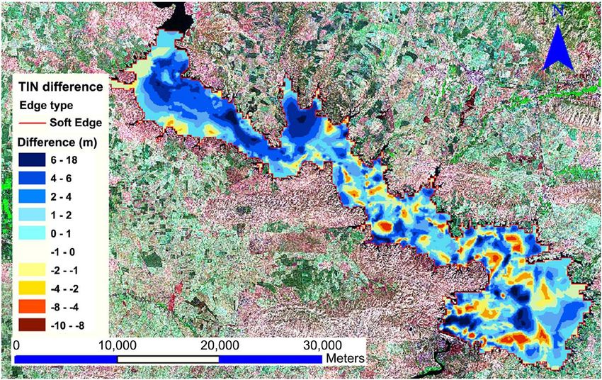
N. Al-Ansari et al.

                               Figure 1. Location of Iraq.

                               population of about 40 million. The climate is mainly continental, subtropical
                               and semi-arid [1]. The Tigris and Euphrates Rivers form the main water re-
                               sources of Iraq. Both rivers rise in Turkey and the water coming from Turkey to
                               Iraq is about 71% while about 6.9% and 4% come from Iran and Syria respec-
                               tively (Figure 2) [2] [3] [4].
                                 To protect the country from floods, ensure the required quantities of water for
                               irrigation and for power generation, number of dams, barrages and hydrological
                               projects were implemented [5]-[15]. The long-term average of the flow of the
                               Tigris River is 21.2 km3 and its tributaries contribute 24.78 km3. The Euphrates
                               contributes 30 km3 (which might fluctuate from 10 to 40 km3) [16] [17] [18]. All
                               the water of the Euphrates River comes from outside the borders of Iraq while
                               67% of the Tigris water also comes from outside source [19].
                                 Iraq used to consume about 42.8 km3 of water in 1990. Most of it is consumed
                               for agricultural purposes (90%) while 4% and 6% are consumed for domestic
                               and industrial purposes. [19] [20] [21] stated that 85% of the water withdrawal is
                               used for agricultural purposes recently. All urban areas received safe water sup-
                               plies while 54% of rural areas receive safe water supplies. After the Gulf war, the
                               situation deteriorated for water and sanitation sectors and accordingly 1/3 of the
                               population of Iraq do not have access to potable water [22].
                                 Despite the fact that the Middle East is considered as arid to semi-arid area,
                               Iraq used to be considered as rich in its water supplies until 1970. After that, the
                               conditions changed due to climate change and construction of dams and irriga-
                               tion projects by riparian countries [23]-[36]. In view of the current situation, it is
                               of prime importance that Iraq should act to ensure water availability. One of the
                               important measures to be taken in this context is the safety of the existing dams.
                               In this context, Mosul Dam (the biggest dam in Iraq) experienced some prob-
                               lems [37]-[73]. This paper describes the problems of Mosul Dam and the meas-
                               ures taken to stabilize the dam. The goal of this work is to show the real status of
                               the dam now.

DOI: 10.4236/eng.2021.133009                         106                                                 Engineering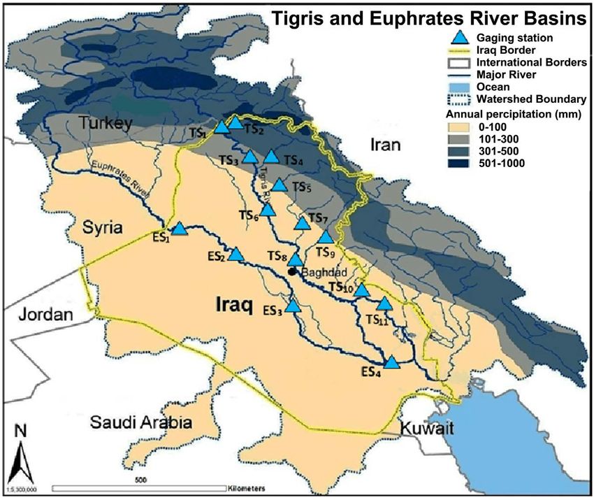
N. Al-Ansari et al.
Figure 2. Sources of water for the Tigris and Euphrates Rivers (modified from [4]).
2. Mosul Dam Project
Mosul Dam is the biggest dam in Iraq and second biggest dam in the Middle
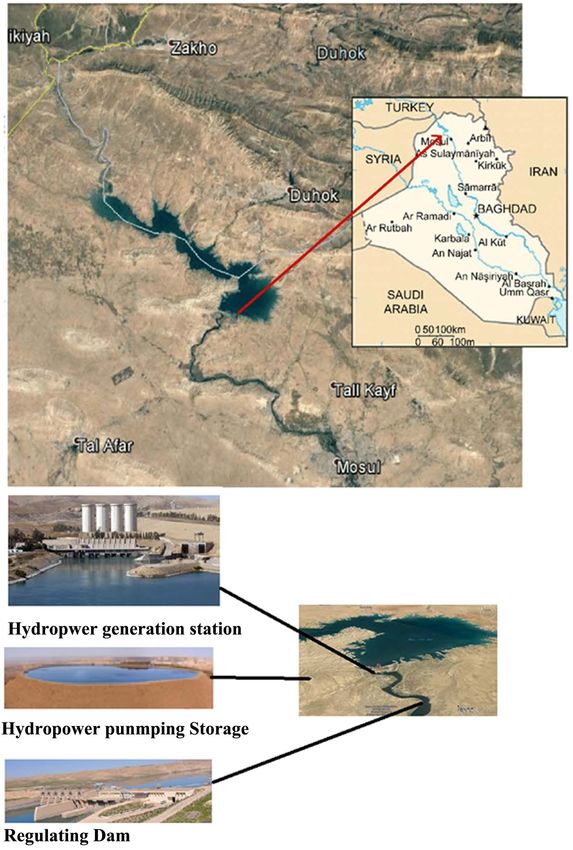
East. It is located 60 km northwest of Mosul city (Figure 1 and Figure 3) [37]
[38]. The construction of the dam started on 25 January 1981 and it started op-
erating on 7 July 1986. The dam is multi objective projects where it provides wa-
ter for three irrigation projects, flood control and hydropower generation. It is
113 m in height and 3650 m long including its spillway. Its top width is 10 m at
341 meters above sea level (a.s.l.). The normal, maximum and dead storage levels
330,335 and 300 m (a.s.l.). It is an earth fill type with a mud core. The reservoir
is designed to impound 11.11 km3 at normal operational level (8.16 and 2.95 km3
of live and dead storage respectively) (Figure 4). The dam has a concrete spill-
way located on the left abutment and has five radial gates measuring 13.5 m ×
13.5 m giving a discharge of 12,600 m3∙sec−1 at the maximum reservoir level of
338 m (a.s.l.) and its crest elevation of the spillway is 330 m (a.s.l.) and its length
is 680 m [38]. The power generation facilities are located on and in the right ab-
utment of the main dam and at the crest of the nearby hill the hydropower
pumping storage is located (Figure 3). At the toe embankment of the dam, the
powerhouse is located (Figure 3) and includes four turbines with total generat-
ing capacity of 750 MW and the pumping storage generates 240 MW. At the
northern part of the reservoir, North Al-Jazeera pumping station is located with
a maximum water discharge 45 m3∙sec−1 (Figure 3) [38].
The reservoir of Mosul Dam is almost elongated shape where the River Tigris
enters the upper zone and expands close to the dam site. Its length is about 45
DOI: 10.4236/eng.2021.133009 107 Engineering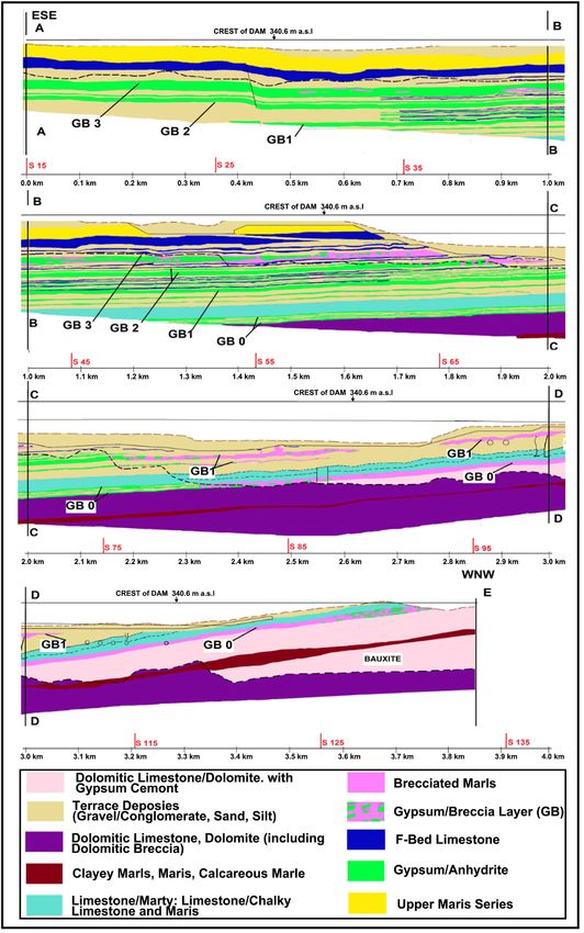
N. Al-Ansari et al.

                                  Figure 3. Location of Mosul Dam with main facilities.

                                                                                                335 m a.s.l 341 m a.s.l
                                                                                                            ffl
                                                                                                ffl

                                                           330 m a.s.l   Max. operation level
                                                           ffl
                                                                                                           10m
                                Normal operation level
                                (storage capacity =11.11 km3)

                                                         Live storage capacity = 8.16 km3

                                                           300 m a.s.l
                                                           ffl

                                  Min. operation level
                                         Dead storage capacity = 2.95 km3
                                                                                   Earth fill
                                              247 m a.s.l                            shell
                                               ffl                                                       Clay core

                               Figure 4. Schematic diagram of Mosul Dam cross section.

DOI: 10.4236/eng.2021.133009                                     108                                                      Engineering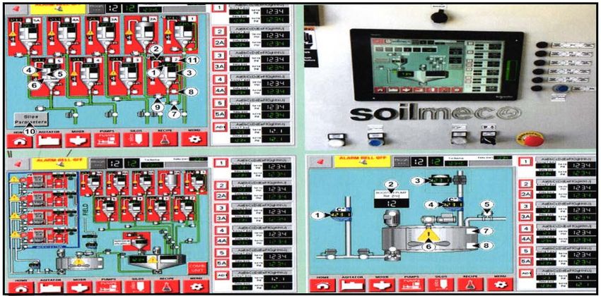
N. Al-Ansari et al.

                               km and its width ranges from 2 to 14 km with a water surface area of about 380
                               km2 at the maximum operation level of 330 m (a.s.l.). There are ten main valleys
                               that feeding the reservoir (7 from the left side and 3 from the right side) [39].

                               3. Geology of the Area
                               The dam lies parallel to Butmah East anticline which is trending E-W with a
                               gentle northern limb. The exposed rocks within the dam site and its reservoir
                               area are the limestone and dolostone beds with soft marl beds of the Euphrates
                               Formation (Lower Miocene) and the Fatha Formation (Middle Miocene)
                               which consists of two members (Lower and Upper). The geology of the area is
                               very complicated and for this reason number of investigations were carried out
                               [40]-[49]. These members consist of cyclic sediments starting with green soft
                               marl, hard limestone and hard gypsum (Figure 5 and Figure 6). Due to the in-
                               homogeneity of the rocks; in their mechanical behavior will certainly behave
                               differently when are loaded.

                                  Figure 5. Geologic map of Mosul Dam site area (After [48]).

                               Figure 6. Intersecting cross sections from intermediate version of ERDC geologic con-
                               ceptual model, showing complex stratigraphy and partial resolution of discrepancies in
                               stratigraphy at intersections of the geologic panels from generated boreholes. (After [49]).

DOI: 10.4236/eng.2021.133009                          109                                                     Engineering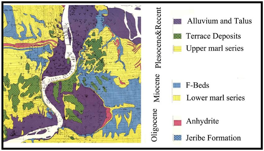
N. Al-Ansari et al.

                                  Gypsum and limestone beds are usually karstified, but the karstification is less
                               in the Upper Member as compared to Lower Member of the Fatha Formation.
                               This is due to the presence of more clastics in the Upper Member than that of
                               the Lower Member of the Fatha Formation, besides that gypsum and limestone
                               beds become thin in the uppermost parts of the formation. [50] [51]. The most
                               influential geological feature is the karstification especially in the foundation’s
                               rocks [41] [45] [50]-[55].

                               4. Problem of Mosul Dam
                               The nature of the rocks (e.g. limestone and gypsum) within the abutments and
                               foundations Mosul Dam site (Figure 7) have high dissolution ability, which are

                                     Figure 7. Geologic cross sections along the axis of the dam ([47]).

DOI: 10.4236/eng.2021.133009                        110                                                    Engineering
N. Al-Ansari et al.

                               highly karstified [47] (Al-Ansari et al., 2015). Most of the karst forms are sink-
                               holes that were developed in gypsum and/or limestone [56]-[67] (Figures 8-10).
                               The karst extends to a depth of about 100 m below the dam foundation (Figure
                               8).
                                  Sinkholes in the downstream of the dam are believed to be developed due to
                               fluctuations in the tail water level of the main dam during operation of the dam
                               and the down-stream regulating reservoir [41] (Washington Group Internation-
                               al, 2005). Before the impoundment of the reservoir, substantial flows of order of
                               360 l/s were noticed from a gypsum layer found during excavation of the tailrace
                               tunnel for the pumped storage scheme. The seepage water had a high sulphate
                               content, which was different from the reservoir water (Figure 9(B)). These

                                  Figure 8. Location of the Karst line ([55]).

                               Figure 9. (A) One of the four sinkholes which had appeared in the 90’s at the down-
                               stream right bank near the contractor yard. (B) Spring of discharge 360 l/s which is con-
                               nected to the ground water aquifer connected to the reservoir ([47]).

                               Figure 10. An example of sinkhole that apeared in 2003. The left bank sinkhole after full
                               development ([47]).

DOI: 10.4236/eng.2021.133009                         111                                                    Engineering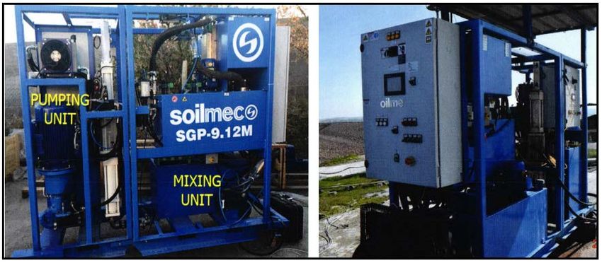
N. Al-Ansari et al.

                               sinkholes are believed to be connected to the aquifer on the right bank of the re-
                               servoir. There are other forms of features such as Karren, shafts, channels also.
                               When the reservoir was filled to its normal operational level (330 m a.s.l.) for the
                               first time new sinkholes appeared downstream (Figure 10). In addition, many
                               other seepages were observed with high sulphide water which indicates dissolu-
                               tion of the gypsum [57].
                                 The operation of the reservoir had led to a new groundwater dynamic that
                               accelerated the dissolution of gypsum under the foundation of the dam and
                               within the reservoir area. A sediment and bathymetric survey was conducted
                               during 2011 to the reservoir area and the bathymetric map (Figure 11) showed
                               formation of sinkholes within the bottom of the reservoir [68]-[75].
                                 In addition to the above, several researches were conducted to check the sta-
                               bility of Mosul Dam [76] [77] [78] [79] [80]. Settlite based work indicated that
                               there is local differential settlement in the body of Mosul Dam. The results of
                               different work published showed that the settlement varies from 5 - 15 mm/year
                               [76] [77] [78] [79] [80]. This subsidence is believed to be mainly due to hetero-
                               geneous decline in the dictates of the dam and not in the foundations according
                               to the consultants who designed the Mosul Dam.

                               5. Protective Measures
                               In view of the situation of Mosul Dam that has been discussed above, there were
                               several measures taken to overcome the problem. These measures can be sum-
                               marized in this section.
                                 Grouting operations were carried out since the start of building the dam to
                               overcome the problem of karstification and jointing of the rocks [56]-[67].
                               Blanket grouting was done under the core of the main dam. The purpose of this
                               type of grouting was to make sure to fill all the openings due to karstification

                               Figure 11. Holes noticed at the bed of Mosul reservoir [73].

DOI: 10.4236/eng.2021.133009                         112                                               Engineering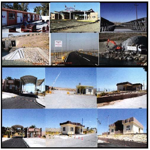
N. Al-Ansari et al.

                               and jointing. In addition, deep curtain grouting was performed to stop the see-
                               page in the foundations under the dam, also to reduce the permeability of the
                               grouted zone (see Figure 8). Lugeon tests were used to make sure that grouting
                               operations fulfilled the engineering requirements. The aim was to close all the
                               openings within the rocks under the foundation of the dam. Due to the dissolu-
                               tion of gypsum, there were openings created within the deep curtain. To close
                               these openings, massive grouting operations were performed. Despite all the
                               maintenance program, which was carried out seepage of water under the foun-
                               dation, did not stop and in fact the situation was worsening.
                                  To evaluate the conditions of Mosul Dam, the US Army Corps of Engineers
                               [47] (Kelly et al. 2007) used the rock quality designation (RQD) (Deere and
                               Deere 1989) as an index for the description of rock mass fractured state. This test
                               was performed on samples taken in years of 1989 and 2006. The results showed
                               that the samples were deteriorating where RQD results were 45% - 65% for the
                               year 1989 and 0% - 20% for the year 2006. It should be mentioned however that
                               these samples were taken within the vicinity of sinkhole SD5 and it does not re-
                               flect the real situation of Mosul Dam foundation. In addition, it was noticed that
                               there were places that highly deteriorated within the deep curtain and the disso-
                               lution front had progressed 350 m toward the east i.e. an average of about 17
                               m/year. In view of this, the International Board of Experts for Mosul Dam de-
                               cided to keep the water level within the reservoir at 319 m a.s.l. [57] [58]. This is
                               to minimize the loses in case of dam failure and it will also decrease the quantity
                               of dissolution of gypsum.

                               6. Islamic State of Iraq and Syria (ISIS) Occupation of the
                                  Dam Area
                               ISIS occupied Mosul Dam area on 8 August 2014 and they were seized back
                               from the hands of ISIS on the 16th of the same month. ISIS destroyed the build-
                               ings, equipment, bridges, etc. on the site (Figure 12). As a result, the grouting

                               Figure 12. Destructions of buildings and bridge as an example of what ISIS did at Mosul
                               Dam site.

DOI: 10.4236/eng.2021.133009                         113                                                  Engineering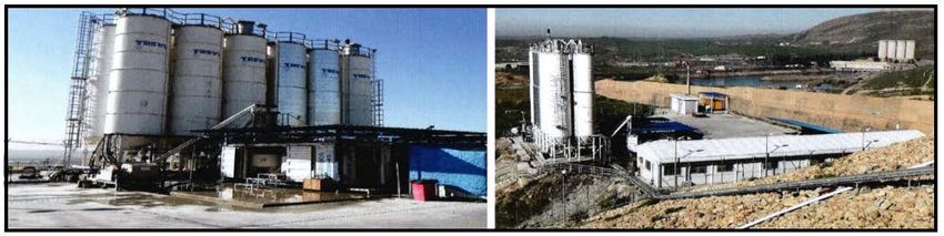
N. Al-Ansari et al.

                               operations were halted which had been taking place for more than 30 years and
                               had consumed more than 95,000 tons of solid grout materials. In view of this,
                               the number of work was done by the US Army Corps of Engineers in 2015 to
                               carry out measurements, surveys and observations to follow developments that
                               might lead to the dam failure [67]. The results of these investigations estimated
                               that about 10,000 m3 of gypsum were dissolved during the period 2014-2016 due
                               to discontinuation of grouting works which was stopped for few months. All
                               these indications led number of researchers to believe that the am is in very crit-
                               ical conditions [77] [78] [79] [81] [82]. Accordingly number of work was carried
                               out [41] [77] [78] [79] [83] [84] [85] to find out the consequences of dam failure
                               and if the work done by the Swiss Consultants was good enough [86] [87] [88].

                               7. Work after ISIS Occupation
                               After the defeat of ISIS from Mosul Dam area, the Iraqi Ministry of Water Re-
                               sources started to rebuild and construct the destroyed parts of the site and
                               started again the maintenance program for the dam (Figure 13). In addition,
                               they signed a contract with an Italian company (Trevi) (contract No. 1002/2016)
                               to do maintenance work at Mosul Dam area. The work mainly included the re-
                               habilitation of one of the bottom outlet gates and grouting.
                                  In addition to the above-mentioned work, the D.G. of Dams did a very good
                               training program with Trevi in maintenance grouting and rehabilitation of bot-
                               tom outlet for the personnel working (Figure 14) and another course with the
                               US Army Corps of Engineers (Figure 15). After doing these training courses, the

                                 Figure 13. Reconstruction of different sites in Mosul Dam area after ISIS occupation.

DOI: 10.4236/eng.2021.133009                         114                                                    Engineering
N. Al-Ansari et al.
Figure 14. Flow chart of training program for engineers at Mosul Dam with the Italian
company “Trevi”.
Figure 15. Grouting system used at Mosul Dam site.
DOI: 10.4236/eng.2021.133009 115 EngineeringN. Al-Ansari et al.
staff at Mosul Dam project were qualified to take the responsibilities in main-
tenance, grouting and operation of the dam.
Grouting operations now follow very highly upgraded system (Figure 15).
Furthermore, advanced stations and equipment for preparing and pumping
grout mix are used now. All the operation is computerized. All electrical cables
(98 km long) were replaced in grouting galleries. Pipes that are used for pump-
ing grout mix (15 km long with 1.5-inch diameter) and water pipes (5.7 km long
and 6 inches diameter) were all replaced (Figure 16).
New 18 drilling machine are used now where 11 of them are electric machines
and the remainder are diesel-operating machines (Figure 17). All drilling ma-
chines are equipped with advanced technologies to register drilling speed, rota-
tions per minute and liquid pressure. This gives accurate information about the
beds and all data are displayed on the computer. Three preparation and grout
pumping stations were installed that covers all the required areas (Figure 18)
and there are 32 secondary grout-pumping stations (Figure 19). It should be
mentioned however, that the grout mix is prepared using special computer pro-
gram to ensure good required specifications (Figure 20). The overall grouting
operation is controlled from the control room (Figure 21). From this room all
grouting operations are monitored and can be controlled. In addition, all the
Figure 16. Electrical cables (A) and water pipes (B) were replaced in all galleries at Mosul
Dam site.
Figure 17. Drilling machines used at Mosul Dam, (A) Small Diesel machine (B) large
machine (C) Small machine for tight areas.
Figure 18. Grout mixing and pumping stations.
DOI: 10.4236/eng.2021.133009 116 EngineeringN. Al-Ansari et al.
Figure 19. Secondary Grout mixing and pumping stations.
Figure 20. The grout mix is prepared using special computer program to ensure good
specifications required.
Figure 21. Control room for Grout operations.
data concerning this operation is stored and data base is prepared for all grout-
ing operations.
It is noteworthy to mention that different galleries and tunnels were cleaned
and repaired from grout waste mainly Aljazera irrigation tunnel. This tunnel is
450 m long with 6 m diameter which is lined by concrete layer 1 m thick and
another iron layer 18 mm thick (Figure 22).
DOI: 10.4236/eng.2021.133009 117 EngineeringN. Al-Ansari et al.
Figure 22. Cleaning operations at Aljazera irrigation tunnel.
8. Conclusions
Mosul Dam was built on alternating beds of limestone, gypsum and marls. These
rocks were highly karstified and jointed. It seems that there were some geologi-
cal misinterpretations of the geological conditions of the site. These faulty inter-
pretations can be summarized as follow:
1) The depth drawn by the designers to indicate the depth of grouting to fill all
cavities ignored some of the gypsum beds that are present below that depth. It
seems that these beds were affected by the water particularly one impounding
started. Some of these beds were dissolved and cavities were developed. For this
reason, grouting material was going down to these cavities, which are located be-
low the curtain-grouting limit. It should be mentioned however, that if grouting
operations for karstified rocks in dam sites are not performed correctly [89], or
when performed by using miss interpreted data [42], the results will be negative.
2) Some samples collected from some boreholes were reddish brown clay de-
scribed as bauxite. Actually, they are Terra Rossa, which is a very good indica-
tion for karst [90]. These were not grouted and neglected.
For the above reasons, seepage of water started once the reservoir was im-
pounded. The process of karstification is an ongoing process and expected to
continue with the limestone and gypsum beds and for this reason, grouting is to
be performed continuously to minimize the seepage. In view of this situation,
the International Board of Experts recommended to keep the water level at 219
m a.s.l. instead of the normal operation level (330 m.a.s.l.). This is to lower the
pressure of impounded water on the dam and the rocks on the site to minimize
the seepage and the damage will be minimum in case of dam failure.
It is noteworthy to mention that, the present grouting operations and perfor-
mance of maintenance work by the Iraqi engineers in Mosul Dam site are excel-
lent. This indicates that the dam is safe at its present water level within its reser-
voir at 319 m.a.s.l. In addition, the impounding was raised 325 m.a.s.l. for few
days and nothing abnormal was noticed.
Acknowledgements
We would like to thank the Iraqi Ministry of Water Resources for providing the
data and arranging field trips.
Conflicts of Interest
The authors declare no conflicts of interest regarding the publication of this paper.
DOI: 10.4236/eng.2021.133009 118 EngineeringN. Al-Ansari et al.
References
[1] Al-Ansari, N. (2021) Topography and Climate of Iraq. Journal of Earth Sciences and
Geotechnical Engineering, 11, 1-13. https://doi.org/10.47260/jesge/1121
[2] Al-Ansari, N. (2021) Water Resources of Iraq. Journal of Earth Sciences and Geo-
technical Engineering, 11, 15-34. https://doi.org/10.47260/jesge/1122
[3] Al-Ansari, N., Adamo, N. and Sissakian, V.K. (2019) Hydrological Characteristics
of the Tigris and Euphrates Rivers. Journal of Earth Sciences and Geotechnical En-
gineering, 9, 1-26.
[4] ESCWA (Economic and Social Commission for Western Asia) (2013) Inventory of
Shared Water Resources in Western Asia. Salim Dabbous Printing Co., Beirut, 626
p.
[5] Abdullah, M., Al-Ansari, N. and Laue, J. (2019) Water Resources Projects: Large
Storage Dams. Journal of Earth Sciences and Geotechnical Engineering, 9, 109-135.
[6] Abdullah, M., Al-Ansari, N. and Laue, J. (2019) Water Resources Projects in Iraq,
Reservoirs in the Natural Depressions. Journal of Earth Sciences and Geotechnical
Engineering, 9, 137-152.
[7] Abdullah, M., Al-Ansari, N. and Laue, J. (2019) Water Resources Projects in Iraq:
Barrages. Journal of Earth Sciences and Geotechnical Engineering, 9, 153-167.
[8] Abdullah, M., Al-Ansari, N. and Laue, J. (2019) Water Resources Projects in Iraq,
Irrigation Projects on Euphrates. Journal of Earth Sciences and Geotechnical Engi-
neering, 9, 169-199.
[9] Abdullah, M., Al-Ansari, N. and Laue, J. (2019) Water Resources Projects in Iraq,
Irrigation Projects on Tigris. Journal of Earth Sciences and Geotechnical Engineer-
ing, 9, 201-230.
[10] Abdullah, M., Al-Ansari, N. and Laue, J. (2019) Water Resources Projects in Iraq,
Irrigation Projects on Tigris River Tributaries. Journal of Earth Sciences and Geo-
technical Engineering, 9, 231-247.
[11] Abdullah, M., Al-Ansari, N. and Laue, J. (2019) Water Resources Projects in Iraq,
Irrigation. Journal of Earth Sciences and Geotechnical Engineering, V. 9, 4,249-274.
[12] Abdullah, M., Al-Ansari, N. and Laue, J. (2019) Water Resources Projects in Iraq,
Main Drains. Journal of Earth Sciences and Geotechnical Engineering, 9, 275-281.
[13] Abdullah, M., Al-Ansari, N. and Laue, J. (2019) Water Resources Projects in Iraq,
Medium and Small Storage Dams. Journal of Earth Sciences and Geotechnical En-
gineering, 9, 283-289.
[14] Abdullah, M., Al-Ansari, N., Adamo, N., Sissakian, V. and Laue, J. (2020) Irrigation
Major Systems on Euphrates River within Mesopotamia. Journal of Earth Sciences
and Geotechnical Engineering, 10, 199-219.
[15] Abdullah, M. and Al-Ansari, N. (2021) Irrigation Projects in Iraq. Journal of Earth
Sciences and Geotechnical Engineering, 11, 35-160.
https://doi.org/10.47260/jesge/1123
[16] Al-Ansari, N.A., Knutsson, S. and Ali, A. (2012) Restoring the Garden of Eden, Iraq.
Journal of Earth Sciences and Geotechnical Engineering, 2, 53-88.
[17] Al-Ansari, N. (2019) Agricultural Activities and Hydropolitics of the Tigris and
Euphrates Rivers. Conference on the Development of Agricultural Sector in Iraq:
problems and Solutions, London, 29 June, 2019.
[18] Al-Ansari, N.A. and Knutsson, S. (2011) Toward Prudent Management of Water
Resources in Iraq. Journal of Advanced Science and Engineering Research, 1, 53-67.
DOI: 10.4236/eng.2021.133009 119 EngineeringN. Al-Ansari et al.
[19] World Bank (2006) Iraq: Country Water Resources, Assistance Strategy: Addressing
Major Threats to People’s Livelihoods. Report No. 36297-IQ, 97 p.
[20] Al-Ansari, N. (1998) Water Resources in the Arab Countries: Problems and Possible
Solutions. UNESCO International Conference on World Water Resources, Paris,
3-6 June 1998, 367-376.
[21] Sadik, A.K. and Barghouti, S. (1995) The Water Problems of the Arab World: Man-
agement of Scarce Water Resources. In: Rogers, P. and Lydon, P., Eds., Water in the
Arab World, Harvard University Press, Cambridge, 4-37.
[22] IMMPW Iraqi Ministry of Municipalities and Public Work (2011) Water Demand
and Supply in Iraq: Vision, Approach and Efforts, GD for Water.
https://www.globalsecurity.org/military/world/iraq/public_works.htm
[23] IPCC (2014) “Climate Change 2014 the Physical Science Basis”: Contribution of
Working Group I to the Fifth Assessment Report of the Intergovernmental Panel on
Climate Change. Cambridge University Press, Cambridge.
[24] Adamo, N., Al-Ansari, N., Sissakian, V.K., Knutsson, S. and Laue, J. (2018) Climate
Change: Consequences on Iraq’s Environment. Journal of Earth Sciences and Geo-
technical Engineering, 8, 43-58.
[25] Al-Ansari, N.A., Ali, A.A. and Knutsson, S. (2015) Iraq Water Resources Planning:
Perspectives and Prognoses. ICCCE 2015: XIII International Conference on Civil and
Construction Engineering, Jeddah, Saudi Arabia, 26-27 January 2015, 2097-2108.
[26] Al-Ansari, N.A. (2016) Hydropolitics of the Tigris and Euphrates Basins. Engineer-
ing, 8, 140-172. https://doi.org/10.4236/eng.2016.83015
[27] Al-Ansari, N.A., Abdellatif, M., Ezeelden, M., Ali, S. and Knutsson, S. (2014) Cli-
mate Change and Future Long Term Trends of Rainfall at North-East Part of Iraq.
Journal of Civil Engineering and Architecture, 8, 790-805.
https://doi.org/10.17265/1934-7359/2014.06.014
[28] Al-Ansari, N., Adamo, N., Sissakian, V., Knutsson, S. and Laue, J. (2018) Geopolit-
ics of the Tigris and Euphrates Basins. Journal of Earth Sciences and Geotechnical
Engineering, 8, 187-222.
[29] Al-Ansari, N.A. (2013) Management of Water Resources in Iraq: Perspectives and
Prognoses. Journal of Engineering, 5, 667-684.
https://doi.org/10.4236/eng.2013.58080
[30] Abbas, N., Wasim, S.A. and Al-Ansari, N.A. (2016) Assessment of Climate Change
Impacts on Water Resources of Khabour in Kurdistan, Iraq. J. Environmental Hy-
drology, 24, 1-21.
[31] Abbas, N., Al-Ansari, N., Wasimi, S. and Al-Rawabdeh, A.M. (2019) Flow Variation
of the Major Tributaries of Tigris River Due to Climate Change. Engineering, 11,
437-442. https://doi.org/10.4236/eng.2019.118031
[32] Abbas, N., Wasimi, S.A. and Al-Ansari, N. (2017) Impacts of Climate Change on
Water Resources of Greater Zab and Lesser Zab Basins, Iraq, Using Soil and Water
Assessment Tool Model. International Journal of Environmental, Chemical, Eco-
logical, Geological and Geophysical Engineering, 11, 823-829.
https://doi.org/10.17265/1934-7359/2016.12.009
[33] Abbas, N., Wasimi, S.A. and Al-Ansari, N. (2020) Impacts of Climate Change on
Water Resources of Fitzroy River and Tigris River Basins and Identification of
Adaptation Measures. PhD Thesis, University of Central Queensland, Rockhamp-
ton.
[34] Abbas, N., Wasimi, S.A., Al-Ansari, N. and Nasrin Baby, S. (2018) Recent Trends
DOI: 10.4236/eng.2021.133009 120 EngineeringN. Al-Ansari et al.
and Long-Range Forecasts of Water Resources of Northeast Iraq and Climate
Change Adaptation Measures. Water, 10, 1562. https://doi.org/10.3390/w10111562
[35] IOM (International Orgaization for Migration) (2020) Water Quality and Quantity
in Central and South Iraq: A Preliminary Assessment in the Context of Displace-
ment Risk.
https://reliefweb.int/report/iraq/water-quantity-and-water-quality-central-and-sout
h-iraq-preliminary-assessment-context
[36] United Nations (UN) (2010) Water Resources Management White Paper. United
Nations Assistance Mission for Iraq, United Nations Country Team in Iraq, 20 p.
https://www.unwater.org/
[37] Sissakian, S., Adamo, N. and Al-Ansari, N. (2019) The Role of Geological Investiga-
tions for Dam Siting: Mosul Dam a Case Study. 1st International Conference on
Forecasting Water in the Future of Iraq: Using the Past and Present, Sulaimainyah
University, Iraq, 13-15 September.
[38] Iraqi Ministry of Water Resources, Water Resources, Mosul Dam.
[39] Ezz-Aldeen, M., Al-Ansari, N.A. and Knutsson, S. (2012) Sediment Delivery from
Right Bank Valleys to Mosul Reservoir, Iraq. Journal of Ecology and Environmental
Sciences, 3, 50-53.
[40] Wakeley, L.D., Kelley, J.R., Talbot, C.A., Pearson, M.L. and Broadfoot, S.W. (2007)
Geologic Conceptual Model of Mosul Dam. U.S. Army Engineer Research and De-
velopment Center, Vicksburg, 61 p.
https://www.researchgate.net/publication/235070116_Geologic_Conceptual_Model
_of_Mosul_Dam
[41] Washington Group International, Black and Veatch, J.V. (2005) Mosul Dam Study.
Final Report, Task Order No. 8, Republic of Iraq Project Contracting Office, Provi-
sional Coalition Authority.
[42] Adamo, N., Al-Ansari, N.A., Sissakian, V., Knutsson, S. and Laue, J. (2018) Mosul
Dam: Full Story, Dar Albasghaer Al-Islamiyah, Beruit, 351 p. (In Arabic)
[43] Sissakian, V.K. and Fouad, S.F. (2012) Geological Map of Iraq, Scale 1:1000000. 4th
Edition, Iraq Geological Survey Publications, Baghdad.
http://www.scirp.org/reference/ReferencesPapers.aspx
[44] Sissakian, V., Al-Ansari, N.A., Issa, I.E., Adamo, N. and Knutsson, S. (2015) Mys-
tery of Mosul Dam the Most Dangerous Dam in the World: General Geology. Jour-
nal of Earth Sciences and Geotechnical Engineering, 5, 1-13.
[45] Al-Ansari, N.A., Al-Jabbari, M., Barazachi, A. and Gayarah, A. (1984) Geological,
Geophysical and Hydrological Investigation of Mosul Dam Area. Report Submitted
to the Iraqi Ministry of Irrigation.
[46] Al-Ansari, N.A., Issa, I.E., Sissakian, V., Adamo, N. and Knutsson, S. (2015) Mys-
tery of Mosul Dam the Most Dangerous Dam in the World: The Project. Journal of
Earth Sciences and Geotechnical Engineering, 5, 15-31.
[47] Al-Ansari, N.A., Adamo, N., Issa, I.E., Sissakian, V. and Knutsson, S. (2015) Mys-
tery of Mosul Dam the Most Dangerous Dam in the World: Karstification and
Sinkholes. Journal of Earth Sciences and Geotechnical Engineering, 5, 33-45.
[48] IVO, Imatran Voima Osakeyhtio (1969) Consulting Engineers, Finland, Geologic
Map of Mosul Dam. Ministry of Agrarian Reform, Baghdad.
[49] Kelly, J., Wakeley, L.D., Broadfoot, S.W., Pearson, M.L., McGill, T.E., Jorgeson, J.D.,
Talbot, C.A. and McGrath, C.J. (2007) Geologic Setting of Mosul Dam and Its En-
gineering Implications. Final Report, U.S. Army Engineer District, Gulf Region,
DOI: 10.4236/eng.2021.133009 121 EngineeringN. Al-Ansari et al.
Baghdad.
[50] Sissakian, V.K. and Al-Mousawi, H.A. (2007) Karstification and Related Problems,
Examples from Iraq. Iraqi Bulletin of Geology and Mining, 3, 1-12.
[51] Sissakian, V.K. (1978) Report on the Geological Mapping of Tuz Khurmatu-Kifri-Kalar
Area. Iraq Geological Survey Library Report No. 902.
[52] Sissakian, V.K. and Ibrahim, F.A. (2004) Geological Hazards Map of Mosul Qua-
drangle, Scale 1:250000. Iraq Geological Survey Library Report No. 2860.
[53] Sissakian, V.K., Al-Ansari, N. and Knutson, S. (2014) Karstification Problems in
Mosul Dam and Its Assessment, North Iraq. Engineering, 6, 84-92.
https://doi.org/10.4236/eng.2014.62012
[54] Swiss Consultants (1979) Mosul Dam Project-Planning Report. State Organization
of Dams, Republic of Iraq, Ministry of Irrigation, Vol. 1.
[55] Mark and Wheeler, Mosul Dam Assessment Task Order No. 8. Report on Site Visit,
Mosul Dam Library, 3-7 September 2004.
[56] Adamo, N., Al-Ansari, N.A., Laue, J., Knutsson, S. and Sissakian, V. (2017) Risk
Management Concepts in Dam Safety Evaluation: Mosul Dam as a Case Study.
Journal of Civil Engineering and Architecture, 11, 635-652.
https://doi.org/10.17265/1934-7359/2017.07.002
[57] Adamo, N. and Al-Ansari, N.A. (2016) Mosul Dam Full Story: Engineering Prob-
lems. Journal of Earth Sciences and Geotechnical Engineering, 6, 213-244.
[58] Adamo, N. and Al-Ansari, N.A. (2016) Mosul Dam Full Story: Safety Evaluation of
Mosul Dam. Journal of Earth Sciences and Geotechnical Engineering, 6, 185-212.
[59] Adamo, N., Al-Ansari, N.A., Issa, I.E., Sissakian, V. and Knutsson, S. (2015) Mys-
tery of Mosul Dam the Most Dangerous Dam in the World: Problems Encountered
During and after Impounding the Reservoir. Journal of Earth Sciences and Geo-
technical Engineering, 5, 47-58.
[60] Adamo, N., Al-Ansari, N., Sissakian, V., Knutsson, S. and Laue, J. (2019) Mosul
Dam: Geology and Safety Concerns. Journal of Civil Engineering and Architecture,
13, 151-177. https://doi.org/10.17265/1934-7359/2019.03.001
[61] Adamo, N., Al-Ansari, N.A., Knutsson, S., Laue, J. and Sissakian, S. (2017) Mosul
Dam: A Catastrophe Yet to Unfold. Engineering, 9, 263-279.
https://doi.org/10.4236/eng.2017.93014
[62] Al-Ansari, N.A., Adamo, N., Sissakian, V., Knutsson, S. and Laue, J. (2017) Is Mosul
Dam the Most Dangerous Dam in the World? Review of Previous Work and Possi-
ble Solutions. Engineering, 9, 801-823. https://doi.org/10.4236/eng.2017.910048
[63] Sissakian, V., Adamo, N. and Al-Ansari, N. (2020) The Role of Geological Investi-
gations for Dam Siting: Mosul Dam a Case Study. Geotechnical and Geological En-
gineering, 38, 2085-2096. https://doi.org/10.1007/s10706-019-01150-2
[64] Sissakian, V., Adamao, N., Al-Ansari, N., Knutsson, S. and Laue, J. (2017) Defects in
Foundation Design Due to Miss-Interpretation of the Geological Data. A Case
Study of Mosul Dam. Scientific Research. Engineering, 9, 683-702.
http://file.scirp.org/Html/5-8102857_78053.htm
https://doi.org/10.4236/eng.2017.97042
[65] Sissakian, V., Al-Ansari, N.A. and Knutsson (2014) Karstification Effect on the Sta-
bility of Mosul Dam and Its Assessment, North Iraq. Engineering, 6, 84-92.
https://doi.org/10.4236/eng.2014.62012
[66] Sissakian, V., Adamo, N., Al-Ansari, N., Knutsson, S., Laue, J. and Elagely, M.
(2018) A Comparative Study of Mosul and Haditha Dams, Iraq: Geological Condi-
DOI: 10.4236/eng.2021.133009 122 EngineeringN. Al-Ansari et al.
tions. Journal of Earth Sciences and Geotechnical Engineering, 8, 35-52.
[67] Al-Ansari, N., Adamo, N., Knutsson, S., Laue, J. and Sissakian, V. (2020) Mosul
Dam: Is It the Most Dangerous Dam in the World? Geotechnical and Geological
Engineering Journal, 38, 1-21. https://doi.org/10.1007/s10706-020-01355-w
[68] Al-Ansari, N.A., Issa, E.I. and Knutsson, S. (2013) Nature of the Distributed of the
Bed Sediment within Mosul Dam Reservoir, Iraq. Al-Rafidain Engineering Journal,
(AREJ), 22, 135-141. https://doi.org/10.33899/rengj.2014.87336
[69] Al-Ansari, N.A., Issa, E.I., Sherwani, G. and Knutsson, S. (2013) Sedimentation in
the Mosul Reservoir of Northern Iraq. Journal of Environmental Hydrology, 21,
Paper 7.
[70] Issa, E.I., Al-Ansari, N.A. and Knutsson, S. (2013) Changes in Bed Morphology of
Mosul Dam Reservoir. Journal of Advanced Science and Engineering Research, 3,
86-95.
[71] Issa, E.I., Al-Ansari, N.A. and Knutsson, S. (2013) Sedimentation and New Opera-
tional Curves for Mosul Dam, Iraq. Hydrological Sciences Journal, 58, 1-11.
https://doi.org/10.1080/02626667.2013.789138
[72] Issa, E.I., Al-Ansari, N.A. and Knutsson, S. (2013) Assessment of Sedimentation
Characteristics and Capacity Curve for Mosul Dam Reservoir, Iraq. 2nd Engineer-
ing Scientific Conference, Mosul, 19-20 November 2013, 20 p.
[73] Issa, E.I., Al-Ansari, N.A., Sherwany, G. and Knutsson, S. (2013) Sedimentation
Processes and Useful Life of Mosul Dam Reservoir, Iraq. Journal of Engineering, 5,
779-784. https://doi.org/10.4236/eng.2013.510094
[74] Issa, I.E., Al-Ansari, N.A. and Knutsson, S. (2014) Mosul Reservoir Sedimentation
Characteristics, Iraq. Journal of Environmental Hydrology, 22, Paper 3.
https://doi.org/10.33899/rengj.2014.87336
[75] Issa, E., Al-Ansari, N.A. and Knutsson, S. (2015) Area-Storage Capacity Curves for
Mosul Dam, Iraq Using Empirical and Semi-Empirical Approaches. International
Commission on Large Dams “ICOLD” Conference, Hydropower 15, Stavanger,
15-16 June 2015, 22 p.
[76] Al-Abayachi, S. (2016) Report on Mosul Dam, Iraqi House of Representatives.
Agriculture, Water, and Marshes Sub-Committee.
https://drive.google.com/file/d/0Byn0PFg9wZ5FNHNQUmxLb0JzenM/view
[77] Coffman, R. (2014) Mosul Dam Could Fail If ISIS Doesn’t Continue Grouting Op-
erations, Expert Says.
https://www.newswise.com/articles/mosul-dam-could-fail-if-isis-doesn-t-continue-
grout-
ing-operations-expert-says-dam-collapse-would-inundate-mosul-and-baghdad
[78] Cetinic, F. (2016) Satellite Based Information to Support Health Analysis of Mosul
Dam. International Workshop on Mosul Dam, Stockholm, 24-25 May 2016, 10 p.
[79] Milillo, P., Burgmann, R., Lundgren, P., Salzer, J., Perissin, D., Fielding, E., Biondi,
F. and Milillo, G. (2016) Space Geodetic Monitoring of Engineered Structures: The
Ongoing Destabilization of the Mosul Dam, Iraq. Scientific Reports, 6, Article No.
37408. http://www.nature.com/articles/srep37408
https://doi.org/10.1038/srep37408
[80] Othman, A.A., Al-Maamar, A.F., Al-Manmi, D.A.M., Liesenberg, V., Hasan, S.E.,
Al-Saady, Y.I., Shihab, A.T. and Khwedim, K. (2019) Application of DInSAR-PSI
Technology for Deformation Monitoring of the Mosul Dam, Iraq. Remote Sensing,
11, 2632. http://www.mdpi.com/journal/remotesensing
https://doi.org/10.3390/rs11222632
DOI: 10.4236/eng.2021.133009 123 EngineeringN. Al-Ansari et al.
[81] MaCleanathan, J.T. (2009) Update for Screening Portfolio Risk Analysis for U.S.
Army Corps of Engineers Dams. Risks and Reliability Directorate, USACE.
[82] U.S. Department of the Interior Bureau of Reclamation (2014) Interim RCEM: Rec-
lamation Consequence Estimating Methodology. Guidelines for Estimating Life Loss
for Dam Safety Risk Analysis, February.
[83] L-Taiee, T.M. and Rasheed, M.M. (2009) Simulation Tigris River Flood Wave in Mo-
sul City Due to Hypothetical Mosul Dam. Thirteenth International Water Technology
Conference, IWTC 13 2009, Hurghada, 12-15 March, 2009.
[84] Mahmud, M.I., Al Azawi, A.O., Abdul Majeed, A.T. and Khalil, T.W. (2015) Mosul
Dam Break Scenario and Its Effects on the Areas along the River Down to Baghdad.
Ministry of Higher Education and Scientific Research, Center for Catastrophes Data
Management and Space Archives, Baghdad. (In Arabic)
[85] Annunziato, A., Andredakis, I. and Probst, P. (2016) Impact of Flood by a Possible
Failure of the Mosul Dam, Version 2. Joint Research Centre (JRC) Technical Re-
ports, EU Commission, April 2016. https://publications.jrc.ec.europa.eu
[86] Swiss Consultants Consortum (1984) Mosul Dam Flood Wave, Summary, Vol. I,
Feb. 1984.
[87] Swiss Consultants Consortum (1984) Mosul Dam Flood Wave, Model Calibration,
Vol. II, Feb. 1984.
[88] Swiss Consultants Consortum (1984) Mosul Dam Flood Wave, Calculation, Vol. III,
Feb. 1984.
[89] Bonacci, O., Gottstein, S. and Roja-Bonacci, T. (2009) Negative Impacts of Grouting
on the Underground Karst Environment. Echohydrology, 2, 492-502.
http://www.nat-hazards-earth-syst-sci.net/13/2041/2013/nhess-13-2041-2013.pdf
https://doi.org/10.1002/eco.90
[90] Merino, E., Banerjee, A. and Dworkin, S. (2006) Dust, Terra Rossa, Replacement,
and Karst: Serendipitous Geodynamics in the Critical Zone. Geochimica et Cosmo-
chimica Acta, 70, A416. http://www.deepdyve.com/lp/elsevier/dust-terra-rossa
https://doi.org/10.1016/j.gca.2006.06.837
DOI: 10.4236/eng.2021.133009 124 EngineeringYou can also read