National Petroleum Reserve in Alaska: 2020 Legacy Wells Strategic Plan - December 2020
←
→
Page content transcription
If your browser does not render page correctly, please read the page content below
U.S. Department of the Interior
     Bureau of Land Management

National Petroleum Reserve in Alaska:
2020 Legacy Wells Strategic Plan

December 2020
Report to U.S. Congress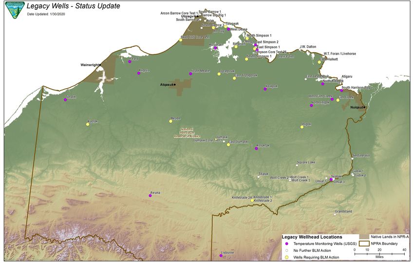
Mission Statement
The Bureau of Land Management sustains the health, diversity, and productivity of the public lands
for the use and enjoyment of present and future generations.
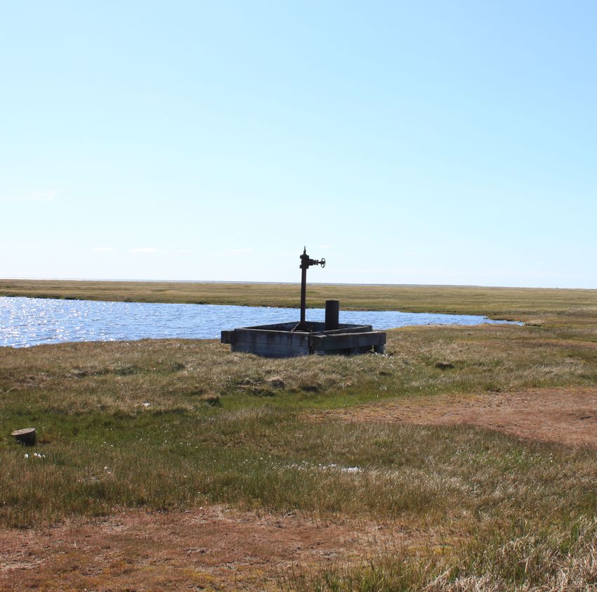
Cover Photo
The West Dease Test Well #1 with associated reserve pit (July 2019).
For More Information
To request a copy of this plan or other BLM Alaska Legacy Well information, please contact—
BLM Alaska Public Information Center
222 W. Seventh Ave., #13
Anchorage, AK 99513
(907) 271-5960TABLE OF CONTENTS
I. EXECUTIVE SUMMARY ................................................................................................................. 1
II. INTRODUCTION............................................................................................................................. 1
III. STATUS OF LEGACY WELLS ...................................................................................................... 1
IV. STRATEGY ................................................................................................................................... 3
V. PRIORITY WELL RANKING .......................................................................................................... 5
VI. STAKEHOLDER ENGAGEMENT ........................................................................................... 9
VII. CONCLUSION.............................................................................................................................. 9
VIII. BIBLIOGRAPHY ....................................................................................................................... 10
APPENDICES................................................................................................................................... 11
APPENDIX 1: MAP................................................................................................................................. 13
APPENDIX 2: RISK ASSESSMENT METHODOLOGY ............................................................................ 15
APPENDIX 3: HISTORICAL TIMELINE – PAST SUCCESS .................................................................... 18I. EXECUTIVE SUMMARY
This report was prepared in response to a directive included in Senate Report 116-123, which
accompanied the Further Consolidated Appropriations Act, 2020 (Public Law 116-94). The
report presents a strategy for completing the remediation of legacy wells within the next ten
years. This report is not intended to circumvent or foreshadow the President’s annual budget
request process under 31 U.S.C. 11, and the resource estimates in this report should not be
construed to imply Administration support for particular levels of appropriations for this program
beyond FY 2021.
A total of 136 wells and core tests were drilled in the National Petroleum Reserve in Alaska
(NPR-A) by the Federal Government between 1944 and 1982. Since 2002, the Bureau of Land
Management (BLM) has spent approximately $155 million cataloging and remediating priority
legacy wells. That effort has led to 99 wells that require no further action and 37 remaining
wells, 17 of which are being used by the United States Geological Survey (USGS) for
temperature monitoring studies. This report focuses on the remaining 20 wells that have been
identified as requiring BLM action. Estimated total costs for completion of remediation of the 20
wells is $136.4 million, or in the range of $125 to $150 million depending on potential efficiency
savings or unforeseen costs. The strategic plan prioritizes and groups the remaining wells.
II. INTRODUCTION
Between 1944 and 1982, the U.S. Navy and USGS conducted exploratory and scientific drilling
programs on Alaska’s North Slope in the Naval Petroleum Reserve No. 4, now called the NPR-
A. In 1976, the BLM was given responsibility for managing the NPR-A, and in 1982 the BLM
inherited the responsibility to assess, plug, and clean up the wells that the U.S. Navy and USGS
left behind (see Appendix 3 for a detailed timeline).
In 2013, the BLM developed the 2013 Legacy Wells Summary Report—a comprehensive, site-
by-site assessment of the condition of the remaining inherited wells—as well as the 2013 Legacy
Wells Strategic Plan. Since that time, the BLM has successfully addressed 30 well sites at a total
cost of approximately $68 million, funded primarily by the Abandoned Wells Remediation Fund,
authorized through the Helium Stewardship Act of 2013, with supplemental funding from the
Management and Land Resources appropriation (see Appendix 3).
The 2013 Legacy Wells Strategic Plan clustered wells together for economies of scale,
specifically in the reduction of mobilization and demobilization costs. Upon completion of those
wells, the remaining wells are further from infrastructure and in certain cases are single wells.
This document, the 2020 Legacy Wells Strategic Plan, addresses those priority wells. For the
purposes of this document, remediation is defined as plugging the well bore to Federal regulatory
standards and surface cleanup activities at a legacy well site. There have been no new legacy
well sites identified since the 2013 report was issued.
III. STATUS OF LEGACY WELLS
This assessment examines all 136 legacy wells that were drilled under the direction of the U.S.
Navy or USGS and groups them into three categories (see Table 1).
1Table 1: Legacy Well Summary Status
Category # of Wells
Wells Requiring No Further BLM Action 99
Temperature-Monitoring Wells (USGS) 17
Wells Requiring BLM Action 20
The 99 wells requiring no additional action include those wells previously remediated by the
BLM, those conveyed to the North Slope Borough (NSB) under the Barrow Gas Field Transfer
Act of 1984 (P.L. 98-366), and shallow uncased test boreholes that present no subsurface or
surface risks.
The USGS is using 17 wells for temperature monitoring for permafrost studies. Due to the threat
of coastal erosion, Tulageak (previously in this group) was moved from the Temperature
Monitoring Well category to Wells Requiring BLM Action. 1 The BLM will continue to work
with USGS to establish a plan for the eventual disposition and remediation of the Temperature
Monitoring Wells when they are no longer necessary for research or as coastal erosion dictates a
need for plugging and remediation.
The 20 wells requiring action are prioritized in this plan based on the surface and subsurface
risks they pose to human health, safety, and the environment. The remaining 17 USGS
temperature monitoring wells will be considered over the life of the strategic plan if a change in
condition occurs; otherwise, they will remain available to USGS to continue its studies. Table 2
summarizes all 136 wells.
Table 2: Legacy Wells Disposition Summary
(Numbers in Parentheses Indicate Number of Wells)
Wells Requiring No Additional BLM Action (99)
Well Category Well Names
Transferred under the Barrow Gas Field Transfer Act South Barrow 4, 5, 6, 7, 8, 9, 10, 11, 12, 13, 14, 15, 16,
(19) 17, 18, 19, 20; Walakpa 1, 2
Transferred under the 1981 Cape Halkett Exchange (1) W.T. Foran 1
Plugged: no subsurface risk, no surface risks (37) Arcon Barrow Core Test 1, Atigaru Point 1, Avak 1,
Barrow Core Rig Test 2, Drew Point 1, East Teshek-
puk 1, JW Dalton 1, North Simpson , Simpson 1,
Simpson Core Test 13, 14, 14A, 15, 26, 27, 28, 29, 30,
30A, 31; South Barrow 1, 2, 3; South Simpson 1,
Square Lake 1, Titaluk1, Umiat 2, 3, 4, 5, 6, 7, 10, 11;
Wolf Creek 1, 2, 3
1 “Coastal erosion threat” is defined as a site that will be at risk of falling into the ocean in the next 10 years. Wells not affected
by coastal erosion are assumed to not need BLM remediation in the next 10 years.
2Well Category Well Names
Shallow, uncased wellbore: no subsurface risk, no sur- Barrow Core Rig Test 1, Ikpikpuk Core Test 1, Ouma-
face risks (35) lik Core Test 1, Oumalik Foundation Tests 1, 2, 3, 4, 5,
6, 7, 8, 9, 10; Simpson Core Tests 1, 2, 3, 4, 5, 6, 7, 8,
9, 10, 11, 12; Simpson Core Tests 16, 17, 18, 19, 20,
21, 22, 23, 24, 25
Cased wellbore, surface inaccessible due to subsequent Barrow Big Rig Test 1
land use by NSB (1)
Plugged well, U.S. Army Corps of Engineers doing Umiat 1, 8, 9
surface cleanup (3)
Transferred to Arctic Slope Regional Corporation in Grandstand 1, Gubik Test 1, Gubik Test 2
1996; requires no more BLM action, plugged and
abandoned (3)
USGS Temperature Monitoring Wells (17)
Well Category Well Name
Wells being used by USGS for temperature monitor- Awuna 1, East Simpson 1, East Simpson 2, Ikpikpuk 1,
ing; future plugging and surface cleanup will be neces- Koluktak 1, Kugrua 1, Kuyanak 1, Lisburne 1, North
sary when no longer in use (17) Inigok 1, North Kalikpik 1, Peard 1, Seabee 1, South
Harrison Bay 1, South Meade 1, Tunalik 1, West Dease
1, West Fish Creek 1
Wells Requiring BLM Action (20)
Well Category Well Name
Require plugging and surface cleanup (18) Cape Halkett 1, East Oumalik 1, East Topagoruk 1,
Fish Creek 1, Iko Bay 1, Inigok 1, Kaolak 1, Knife-
blade 1, 2, 2A; Meade 1, Oumalik 1, Oumalik Core
Tests 2, 11, 12;, Skull Cliff Core 1, Topagoruk 1, Tul-
ageak 1 (active Temperature Monitor Well threatened
by coastal erosion)
Wells with unknown locations; no apparent risk at this Minga Velocity Test 1, Sentinel Hill Core Test 1
time (2)
IV. STRATEGY
The wells are ranked in priority using the risk assessment methodology found in Appendix 2.
The BLM grouped together wells that may be near priority wells for economies of scale, which
reduces the overall cost of mobilization and demobilization per well.
Subject to the availability of funding, the implementation of this strategy for plugging and reme-
diating the remaining 20 wells requiring BLM action could be accomplished within 10 years.
3This timeframe would be subject to change due to unforeseen circumstances that affect a current
project or changing conditions, such as coastal erosion, that would require action on an unex-
pected temperature monitoring well. As noted above, the estimated cost for plugging and remedi-
ating the 20 remaining wells is approximately $125-150 million. That range takes into account
the possibility of opportunistic cost savings or unforeseen expenditures due to unknown condi-
tions. For example, clustering of wells allows for project mobilization and demobilization to be
combined for substantial cost savings. Equipment costs can fluctuate based on demand of oil
field activity. Limited rental camps and equipment are available, as the BLM competes with in-
dustry on a first come, first served basis. Weather delays occur with some regularity due to bliz-
zard conditions or temperatures below -40° F.
The BLM has gained experience in the process of plugging and remediating legacy wells over
the years. While the ability to have no year funds made a difference in the planning and
efficiency of projects – with mobilization as the primary cost, clustering of wells allows for
greater efficiencies over a series of years – the BLM is currently working to structure the
program to work with the new two year funding cycle. The ability to enter into partnerships may
also influence the priority order and pace of legacy well work. Partnerships can help the BLM
leverage resources with other Federal agencies or non-Federal entities that are conducting work
near legacy well sites where additional action is necessary. Those opportunities to share costs
ultimately can benefit all parties. Cooperation from stakeholders has contributed extensively to
legacy wells work. The primary cooperators have been the Alaska Oil and Gas Conservation
Commission (AOGCC), Alaska Department of Environmental Conservation (ADEC), Arctic
Slope Regional Corporation (ASRC), and North Slope Borough (NSB).
Although not a factor in this strategic plan’s priorities and actions, exploration and development
of Federal oil and gas lease tracts in the coming years may also help to facilitate legacy well
plugging and site cleanup. Section 349 of the Energy Policy Act of 2005 allows the BLM to off-
set costs for remediation on lands subject to a new or current lease with royalty relief; this au-
thority has not been used to date. If an operator plugs a legacy well, the cost can be given in roy-
alty relief dollar for dollar. For example, if completing the plugging of a legacy well costs $10
million, that operator may receive $10 million in royalty relief. The BLM has been and will con-
tinue to work closely with industry to identify those opportunities as part of their exploration or
development programs.
The BLM does not plan to plug any temperature monitoring wells currently in use by USGS un-
less they are threatened by coastal erosion but will continue to monitor coastal erosion at those
sites and elevate them in priority as needed due to changing site conditions.
4V. PRIORITY WELL RANKING
1. TULAGEAK
TULAGEAK 1
Subsurface: The well has low subsurface risk because plugs are present that isolate potentially
productive zones. The well is currently in use by USGS for temperature monitoring. Diesel fuel
is present from the top plug to near the surface, and that allows monitoring to occur through the
noncorrosive, nonfreezing medium.
Surface: The surface ranking for this well is high because the threat of coastal erosion is signifi-
cant. The reserve pit is approximately 200 feet from the existing shoreline. Approximately 10–25
feet of coastline is being eroded per year, but it is also possible to lose between 50 and 100 feet
of coastline with severe storm events. The reserve pit was delineated in 2019 to determine the
extent of contaminants requiring removal. The reserve pit contains drilling muds, additives and
cuttings that require removal prior to the reserve pit being compromised by the coastal erosion.
Such a compromise would result in a direct discharge of contaminants into the Beaufort Sea,
which poses a direct or indirect risk to human health (for instance via harvesting of subsistence
species) and the environment.
2. IKO BAY
IKO BAY 1
Subsurface: The subsurface ranking is high because the well continues to have pressure and will
be a complex plugging operation due to current downhole conditions. Previous attempts were
made to complete the plugging of this well in 2016 and 2017. Based on lessons learned, the
BLM has developed a technical solution that is suitable to the downhole challenges.
Surface: The surface cleanup was completed during the winter 2016/2017 seasons.
3. OUMALIK WELLS (5)
EAST OUMALIK 1
Subsurface: The subsurface ranking is moderate because no cement plugs are currently isolating
the geologic horizons. Plugging is required to ensure no hydrocarbons migrate from the for-
mation and the reservoir is not compromised.
Surface: The surface risk is moderate. A refrigerant system of piping was left in place, which
may contain diesel, and other scattered debris is present.
OUMALIK 1
Subsurface: The subsurface ranking is moderate because the uppermost plug in the well is be-
low a formation that contained hydrocarbons. Plugging is required to ensure no hydrocarbons
migrate from the formation and the reservoir is not compromised.
5Surface: This site has been classified as a moderate surface risk because a refrigerant system
used during drilling and minor solid wastes remains at the site. Oumalik 1, Oumalik Core 2,
Oumalik Core 11, and Oumalik Core 12 are within the same operations area.
OUMALIK CORE 2
Subsurface: The subsurface ranking is moderate because no cement plugs are currently isolating
the geologic horizons. Plugging is required to ensure no hydrocarbons migrate from the for-
mation and the reservoir is not compromised.
Surface: Same as Oumalik 1
OUMALIK CORE 11
Subsurface: The subsurface ranking is moderate because no cement plugs are currently isolating
the geologic horizons. Plugging is required to ensure no hydrocarbons migrate from the for-
mation and the reservoir is not compromised.
Surface: Same as Oumalik 1
OUMALIK CORE 12
Subsurface: The subsurface ranking is moderate because no cement plugs are currently isolating
the geologic horizons. Plugging is required to ensure no hydrocarbons migrate from the for-
mation and the reservoir is not compromised.
Surface: Same as Oumalik 1
4. TOPAGORUK WELLS (2)
TOPAGORUK 1
Subsurface: The subsurface ranking for this well is moderate because no plugs are isolating the
formations where hydrocarbon shows were encountered. Plugging is required to ensure no hy-
drocarbons migrate from the formation and the reservoir is not compromised.
Surface: The surface risk ranking is high because of the extensive surface debris present, includ-
ing battery cores, extensive refrigerant piping, and drilling muds.
EAST TOPAGORUK
Subsurface: The subsurface risk ranking is low because the formations containing hydrocarbons
have been isolated.
Surface: The surface ranking is low because only minor solid wastes are present.
5. SKULL CLIFF
SKULL CLIFF CORE TEST 1
Subsurface: The subsurface risk is moderate because no plugs were set in the well.
6Surface: The surface priority is high because solid wastes present a hazard to winter travel, as
Skull Cliff lies within a popular corridor connecting Barrow and Wainwright.
6. KNIFEBLADE WELLS (3)
KNIFEBLADE 1
Subsurface: The subsurface ranking is moderate because no plugs are currently in the well.
Plugging is required to ensure no hydrocarbons migrate from the formation and the reservoir is
not compromised.
Surface: The surface ranking is low because no known debris or contaminants are at the site.
KNIFEBLADE 2
Subsurface: The subsurface ranking is moderate because no plugs are currently in the well.
Plugging is required to ensure no hydrocarbons migrate from the formation and the reservoir is
not compromised.
Surface: The surface ranking is low because a small amount of debris exists at the site.
KNIFEBLADE 2A
Subsurface: The subsurface ranking is moderate because no plugs are currently in the well.
Plugging is required to ensure no hydrocarbons migrate from the formation and the reservoir is
not compromised.
Surface: Same as Knifeblade 2.
7. FISH CREEK
FISH CREEK 1
Subsurface: The well is a moderate subsurface risk because hydrocarbon zones are present that
have not been adequately isolated, and the current plugs are below the productive horizon. Plug-
ging is required to ensure no hydrocarbons migrate from the formation and the reservoir is not
compromised.
Surface: The surface risk is moderate because a deteriorating concrete pad and other solid waste
is present that could pose a risk to local residents.
8. KAOLAK
KAOLAK 1
Subsurface: The subsurface ranking for the well is moderate because no plugs are currently iso-
lating the hydrocarbon zones. Plugging is required to ensure no hydrocarbons migrate from the
formation and the reservoir is not compromised.
7Surface: The surface ranking is moderate because the extensive solid waste poses a travel risk to
subsistence travelers. The BLM has an agreement with the Alaska State Historic Preservation
Office that an archeological assessment will be done before any cleanup or remediation activities
will occur.
9. CAPE HALKETT
CAPE HALKETT 1
Subsurface: The subsurface risk is low because the well is assumed to be adequately plugged
and abandoned; that assumption will be verified when the wellhead is cut off.
Surface: The surface risk is moderate because the metal pilings present a travel hazard to resi-
dents. In low-light or whiteout conditions, the pilings and cement blocks are obscured along this
winter travel route. Drilling wastes and mud were left on the tundra and are subject to occasional
flooding.
10. MEADE
MEADE 1
Subsurface: The subsurface priority is low because the productive gas zone has been isolated
with cement plugs.
Surface: The surface risk is considered moderate because of the potential of diesel fuel leaking
into the surrounding soils from a refrigeration system buried under the tundra.
11. MINGA TEST VELOCITY AND SENTINEL HILL
MINGA TEST VELOCITY 1 AND SENTINEL HILL 1
These two wells are grouped together because their exact locations are currently unknown.
Minga Test Velocity 1 was drilled in a lake in 1950 to test the underlying permafrost with the
casing cut off five feet below the surface. Sentinel Hill 1 was buried in a landslide just months
after it was drilled in 1947. The BLM is taking action by actively monitoring the approximate
well locations and any changing conditions through the use of overflights, aerial imagery, and
exploring other ideas such as lidar. If the wells are found, they will be evaluated for future ac-
tion.
12. INIGOK
INIGOK 1
Subsurface: The well is believed to have been plugged to surface. The subsurface priority is low
because whether adequate cement is present at the surface cannot be verified until the wellhead
is cut off.
Surface: The surface priority is considered low because the reserve pit present was closed by
ADEC in 1995.
8VI. STAKEHOLDER ENGAGEMENT
The 136 wells were vetted through a three-year public process (from 2013–2015) with the
AOGCC, in which downhole properties for each well were examined. Current information and
conditions from the 2013 Legacy Well Summary Report and its citations were examined, along
with re-constructed wellbore diagrams, to determine plugging solutions that would satisfy both
Federal and State regulations. The BLM continues to coordinate with the AOGCC on seasonal
well plugging projects for all phases, including plugging design, procedures, downhole site
condition changes, and contingencies.
Surface sampling lab results are sent to ADEC for each well that is being plugged. The ADEC
provides a high-level review and works together with BLM to ensure that no harmful materials
remain at those locations.
Several legacy wells have been conveyed out of Federal ownership to ASRC. The BLM worked
with ASRC to plug and clean up those wells. In 2019, three wells were plugged on ASRC lands.
The ASRC provided surface clearance and final approval of the surface reclamation.
The BLM has plugged six legacy wells on NSB lands within the vicinity of Utqiaġvik. The BLM
paid the $30,000 site fee per well to the NSB while completing the plugging over two seasons.
The ongoing work required constant coordination with the NSB.
VII. CONCLUSION
The BLM will procure services to remediate the remaining 20 priority wells based on funding
availability.
The BLM will continue to regularly inspect these wells for the following parameters to
determine if any conditions have changed that would require reprioritization: rate of coastal
erosion for those sites within 1,000 feet of the coastline along the Beaufort Sea; erosional
stability of the well site; the integrity (corrosion or failure) of any wellhead protection devices;
visible petroleum contamination related to solid waste or wellhead leaks; other well integrity
issues; and changes in land use patterns or proximity to travel corridors or population centers.
9VIII. BIBLIOGRAPHY
Brumbaugh, Rob, and Stacie MacIntosh. February 2013. “Preliminary Alaska Legacy Wells
Summary Report: National Petroleum Reserve in Alaska.” Bureau of Land Management Open
File Report 127. BLM/AK/ST-13/005+2360+932. 596 pp.
Brumbaugh, Rob and Stan Porhola. 2004. Alaska Legacy Wells Summary Report: National
Petroleum Reserve in Alaska. Bureau of Land Management Open File Report. BLM/AK/ST-
05/004+2360+941. Anchorage, AK. 71 pp.
U.S. Bureau of Land Management. 2013. “National Petroleum Reserve in Alaska: Legacy Wells
Summary Report 2013.” Bureau of Land Management Open File Report. Anchorage, AK.
U.S. Bureau of Land Management and U.S. Geological Survey. 1992. “Environmental Status of
28 Oil and Gas Exploration Areas of Operation in the National Petroleum Reserve-Alaska.”
Bureau of Land Management Publication, Anchorage, AK. 99 pp.
Bureau of Land Management in Alaska 10APPENDICES
Bureau of Land Management in Alaska 11Intentionally left blank Bureau of Land Management in Alaska 12
APPENDIX 1: MAP

                  Bureau of Land Management in Alaska   13
Intentionally left blank Bureau of Land Management in Alaska 14
APPENDIX 2: RISK ASSESSMENT METHODOLOGY
The sites were assigned surface and subsurface risk rankings of none, low, moderate, or high
before also being assessed against more general risk evaluation criteria (see Section C below).
Generally, sites with higher risk rankings were considered for more immediate actions, and those
risk assessments were used to prioritize the actions outlined in this strategic plan. Sites with
lower risk ratings may be completed ahead of higher priority wells, however, if they are near
locations where work is being completed. Note that the existence of a single factor within any of
the surface or subsurface risk categories (none, low, moderate, or high) translates directly into an
assignment of at least that risk category. In other words, it is not necessary for all factors to exist
for a given risk category to be assigned.
The BLM regularly inspects legacy well sites to assess changing conditions, which may result in
different ranking if a change has occurred.
A. SURFACE RISKS
The surface risk assessment is based on the potential of the well or core test site to pose a risk or
negative impact to surface resources and activities, including air, water, vegetation, or wildlife
resources as well as travel and visual resources. To assess surface risk, the BLM evaluated site
conditions surrounding the well or core test.
The BLM assessed and rated the surface risk conditions at each site if it had any of the follow-
ing:
HIGH SURFACE RISK:
A well that may be adversely affected by coastal erosion within 5 years.
Significant solid waste present that affects public safety.
Potential to affect air or water quality because of the discharge of hydrocarbons under
pressure.
MODERATE SURFACE RISK:
A travel or transportation risk to local residents due to surface debris.
Debris that negatively affects visual resources.
Evidence of buried waste on site.
LOW SURFACE RISK:
Minor solid waste present with minimal impact to visual resources or transportation.
No known contaminants documented in historical literature, but not verified.
NONE (NO SURFACE RISK):
No known contaminants present.
Fully remediated, with minor surface disturbance.
Minimal impact to visual resources.
Bureau of Land Management in Alaska 15B. SUBSURFACE RISKS
To determine a well’s or core test’s subsurface risk, the BLM evaluated historical documents,
such as drill logs and geologic reports, and conducted site assessments. The BLM also consid-
ered data on well plugging—including casing and cementing depth and materials—and the com-
position of materials believed to be left in the well.
HIGH SUBSURFACE RISK:
A well or core test at the site that has penetrated oil or gas stratigraphy or water resources
and the well or core test is either leaking hydrocarbons or has a history of leaking
hydrocarbons.
MODERATE SUBSURFACE RISK:
A cement plug is present below the perforations of the producing interval, but some surface
controls are in place, including a wellhead and/or a column of frozen drill mud that
currently isolates the formation. There must be no indication of migration of fluid to
surface.
No cement plugs in the well or core test that encountered oil or gas, but some surface
controls are in place, such as a wellhead or column of frozen drilling mud, currently isolate
the formation; and there is no indication of migration of fluid to the surface.
LOW SUBSURFACE RISK:
Well or core test penetrated oil or gas stratigraphy or water resources, but producible oil
and gas formations or water resources are isolated with adequate cement plugs.
Well that has been historically plugged to surface, but the wellhead has not yet been
removed.
NONE (NO SUBSURFACE RISK):
Well or core test did not penetrate oil or gas stratigraphy or water resources.
Well has been adequately plugged.
Bureau of Land Management in Alaska 16C. ADDITIONAL RISK EVALUATION CRITERIA
In addition to the surface and subsurface risk rankings, the BLM also evaluates risk by consider-
ing a number of different factors for each site, such as the specific impacts on public health and
safety, how the site conditions may affect natural resources or future energy development, the
type and condition of solid waste present, and the manner in which wells were plugged. For each
factor, the BLM evaluates the answers to several specific questions. These criteria do not carry a
specific rating, but rather are meant to augment discussion to apply to the specific well circum-
stances that may affect the overall rating of the well.
Protection of Public Health and Safety
1. Is the well near human activity? If so, are conditions present that pose a risk to people?
2. Did the well encounter any oil or gas? If so, is the well capable of flowing?
3. Is there a wellhead? What is the condition of the wellhead? Have there been any previous
problems or repair work?
4. What is the condition of the existing pad and pits, and is there any indication of contami-
nation? If so, what is the type, nature, and extent of contamination?
Impact on Resources and Future Energy Development
1. Does the well site in its current condition (such as oil and gas resource penetrated, but not
currently isolated with plugs) affect future energy leasing?
2. Does the well site in its current condition pose an unacceptable risk to wildlife, subsist-
ence, and other natural resource uses?
3. Are there open wellbores and cellars in which small animals may become trapped?
4. Is the wellsite threatened by the environment through natural progressions (coastal ero-
sion, fluvial processes, landslides, etc.)?
Solid Waste Characterization
1. Is there a reserve pit associated with the site? Have all reserve pits present received regu-
latory closure from the Alaska Department of Environmental Conservation? Is there a
new concern or information that warrants a new evaluation of those sites? What is the
character (volume and chemical nature) of waste associated with a reserve pit? Are there
any water quality issues present within the reserve pit?
2. What is the surface condition of the existing pad and pits? Is contamination a possibility?
3. What is the inventory of other solid waste (old equipment, piping, barrels, etc.), and do
any associated current conditions pose a potential hazardous material release threat?
Plugging
1. Are there any new risks that were not addressed during the original plugging operation
that may need to be mitigated?
2. Does anything associated with the well possibly make plugging the well technically chal-
lenging?
Bureau of Land Management in Alaska 17APPENDIX 3: HISTORICAL TIMELINE—PAST SUCCESS
The legacy well program has had many past successes. Since 2002, BLM has plugged 39 legacy
wells, with 10 of those located on lands conveyed to other entities. With the exception of three
wells, the remainder have been plugged during the winter months. Traveling overland during the
winter involves specialized heavy-duty equipment so as not to damage the tundra. Snow trails to
the specific legacy well locations are constructed from existing infrastructure, often covering
more than 100 miles. Some notable wells that have been plugged include Umiat #8, previously
known as the whistling well; Gubik #2, another gas well that had such extreme gas pressure that
it had previously caused a well blowout; J.W. Dalton, a USGS monitoring well with a reserve pit
that was the first well plugged due to coastal erosion; and East Teshekpuk, another USGS well
that was threatened from shoreline erosion from Lake Teshekpuk.
1944–1952: The U.S. Navy drills 91 wells 1975–1982: The Navy and USGS drill 28
in the Naval Petroleum Reserve No. 4 (PET- wells through a contract with Husky Oil
4), including 59 cased exploratory wells and Company.
32 uncased core tests.
1980: The NPRPA is amended to direct an
1953–1975: The Navy drills 17 additional expedited program of leasing.
wells near Barrow in support of the Barrow
Gas Field development. 1981: The BLM conveys the W.T. Foran
well to the ASRC.
1976: The Naval Petroleum Reserves Pro-
duction Act of 1976 (NPRPA; Public Law 1982: In January, the Minerals Management
94-258) renames the PET-4 the National Pe- Service (MMS) takes over the functions of
troleum Reserve in Alaska (NPR-A) and or- oil and gas exploration and development
ders the transfer of jurisdiction over the re- from the USGS Conservation Division. In
serve from the Secretary of the Navy to the December, onshore minerals management
Secretary of the Interior, effective June 1, functions are transferred to the BLM via
1977. Secretarial Order 3087.
The law directed the Department of the Inte- The first BLM oil and gas lease sale is held
rior to protect the surface and explore for oil for the NPR-A.
and gas. At the time the law was enacted, 1984: The Barrow Gas Transfer Act trans-
the USGS supervised exploration and devel- fers ownership responsibility of 19 legacy
opment for leases on Federal, Indian, and wells to ASRC.
certain Naval Petroleum Reserve land (to in-
1986: The BLM conveys Grandstand 1 well
clude NPR-A after the transfer).
to ASRC.
1977: The BLM and USGS enter into a
1995: The ADEC issues final closure for 27
Memorandum of Understanding (42 FR
of the USGS reserve pits. ADEC issues one
4542) giving USGS exclusive jurisdiction
reserve pit (East Teshekpuk) conditional
over the South Barrow Gas Field and speci-
closure. BLM conveys Gubik 1 and Gubik 2
fying that BLM and USGS share manage-
wells to ASRC.
ment of the surface areas of operations. The
MOU designated USGS as manager of the 2002: The U.S. Army Corps of Engineers,
continuing exploration program during the under the oversight of the BLM, plugs
interim period between the transfer of juris- Umiat 2 and Umiat 5, at a cost of $25 mil-
diction from the Navy to Interior. lion.
Bureau of Land Management in Alaska 182003: The BLM inspects and evaluates all to classify the risks posed by each well and
136 wells and uncased core test sites to de- prioritize future work.
termine the threat posed to human health, 2015: The BLM awards an indefinite deliv-
safety, and the environment. The 2004 Leg- erable and indefinite quantity (IDIQ) con-
acy Wells Summary Report prioritizes those tract to two Alaska Native-owned compa-
sites with the most immediate need of cor- nies. The IDIQ is very successful using pri-
rective action. marily no-year funding to plug 30 wells in a
2004: The BLM plugs three wells at Umiat, 6-year period.
including the high-pressure Umiat #8, 2016: The BLM plugs three wells in
known locally as the “whistling well.” Utqiaġvik (formerly Barrow) during the
2005: Severe coastal erosion at J.W. Dalton summer months along their road system.
well site triggers an emergency Plug and They are the only legacy wells not plugged
Abandonment and reserve pit removal. during the winter.
BLM-Alaska receives Department of the In- 2019: The BLM plugs Gubik #1, #2, and
terior Environmental Achievement Award Grandstand wells on now-conveyed ASRC
for execution and cost savings at the site. lands. Gubik #2, a high-pressure gas well, is
2006-2010: The BLM focuses on remedia- the first successful open-hole plug set by a
tion of wells and reserve pits that are threat- legacy well contractor. It is also the deepest
ened by coastal erosion. Drew Point was the plug set. These wells were plugged with
most expensive project completed under the MLR funds as they are located just outside
American Recovery and Reinvestment Act the NPR-A boundary.
(ARRA). BLM employs innovative reserve 2020: The BLM completes cleanup efforts
pit content disposal option by engineering of all high-priority well sites identified in
and utilizing an inland reserve pit to store the 2013 Legacy Wells Strategic Plan and
drilling muds, saving millions of dollars in initiates updated strategic plan.
transport and disposal costs.
The BLM publishes Updated Strategic Plan.
2008: BLM-Alaska receives second DOI
Environmental Achievement Award for
plugging and remediation efforts on the East
Teshekpuk well.
2010-2015: The BLM establishes Inter-
agency Agreement with the Army Corps of
Engineers to expedite procurement activity
and utilize qualified environmental contrac-
tors to complete the Umiat well cluster.
2013: The Helium Stewardship Act of 2013
makes $50 million available to the Depart-
ment of the Interior ($10 million in FY
2014, $36 million in FY 2015, and the re-
maining $4 million in FY 2019), without
further appropriation, to remediate, reclaim,
and close priority legacy wells in the NPR-
A. Approximately $3 million of the $50 mil-
lion is permanently sequestered.
2013-2014: The BLM prepares strategic
plan with other agency and stakeholder input
Bureau of Land Management in Alaska 19Total cost and funding source for the past well clusters since 2015
Calendar # Well Cluster Total Cost Remediation MLR Program
Year Wells Fund Amount Fund Amount
2015 3 Umiat $10,500,000 $8,300,000 $2,200,000
2016 9 Simpson $7,700,000 $7,700,000
2016 3 Utqiaġvik (summer) $4,000,000 $4,000,000
2017 3 Utqiaġvik $13,000,000 $13,000,000
2018 5 Wolf Creek $11,000,000 $11,000,000
2019 3 Gubik/Grandstand $10,300,000 $10,300,000
2020 4 Simpson $11,200,000 $3,800,000 $7,400,000
Total 30 $67,700,000 $47,800,000 $19,900,000
*MLR = Appropriated funding for Management of Lands and Resources authorized annually
from an act of Congress (annual budget)
Bureau of Land Management in Alaska 20You can also read