PARC Development Framework September 2021 Draft for Consultation - hunterstonparc.com | KA29 0AZ
←
→
Page content transcription
If your browser does not render page correctly, please read the page content below
Hunterston
PARC
 Development Framework
 September 2021
 Draft for Consultation

hunterstonparc.com | KA29 0AZ
1. Introduction
                                                            One of the key elements of the Hunterston Parc
                                                            framework is a research and development campus
   Overview                                                 which will offer an incubator space for new research
                                                            primarily in the blue/green economy.
   Hunterston PARC offers an unrivalled
   combination of space, facilities and                     Green economy strategies tend to focus on the sectors
   connectivity for Scottish Industry with energy           of energy, transport, sometimes agriculture and forestry,
   at its heart. At nearly a 1,000 acres the site           while the blue economy focuses on fisheries sectors
   is multi-faceted with 320 acres of brownfield            and marine and coastal resources. Both incorporate
   land, a SSSI, a lagoon and a large wooded                strategies to address climate mitigation and adaptation.
   area under a tree preservation order.                    This campus will sit within the blue green principle
                                                            underpinned by the three pillars of the site of Industry,
                                                            the Marine Yard and the Port.

                                                            The development of Hunterston PARC is part of a wider
What is proposed?                                           programme with the Ayrshire Growth Deal, offering
                                                            circa £250 million (of which £18 million is allocated
Under three identified Key themes of Port, Industry         for Hunterston) for the Ayrshire region to level up to
and Marine the site intends to offer a clear potential to   other parts of Scotland and the UK as a whole. This
help deliver on important challenges facing Scotland        development has the potential to transform the Region
and the UK. A table of potential uses is in the Appendix    over a 5-20 year period.
(B) which give granularity to the ability to help tackle
climate change (NetZero 2045) assisting in the delivery
of the circular economy, utilising existing significant
grid connections after the closure of Hunterston B,
exercising the ability of multimodality ( Rail, Sea and
Road) and the important reuse of world class existing
assets helping to tackle increases in carbon production.
                                                              What is the blue/green economy?

The purpose
Building on previous consultations we are now bringing          1. Blue Economy
forward a proposal for a development framework in              Sustainable use of ocean resources for economic
compliance with Local Development Plan 2 (LDP2)                growth improving livelihoods and jobs
and our previous Master Plan consultation for the
repurposing 320-acres of brownfield land in a land
holding of 1000-acres ownership, which offers a
fantastic opportunity for regeneration and enhancement
                                                                2. Green Economy
of natural capital for North Ayrshire and beyond.              Natural capital as a critical economic asset and a
                                                               source of public benefit
The development framework which is the subject of
this consultation seeks to maximise the opportunity
provided by this site by proposing what is seen as the          3. Blue Green Economy
optimal layout, or mix of uses. There will be additional
opportunities to comment on more detailed proposals            Offering a more resilient sustainable growth
as planning applications are submitted for parts of the        through low impact industries and modern
site in line with this framework.                              technologies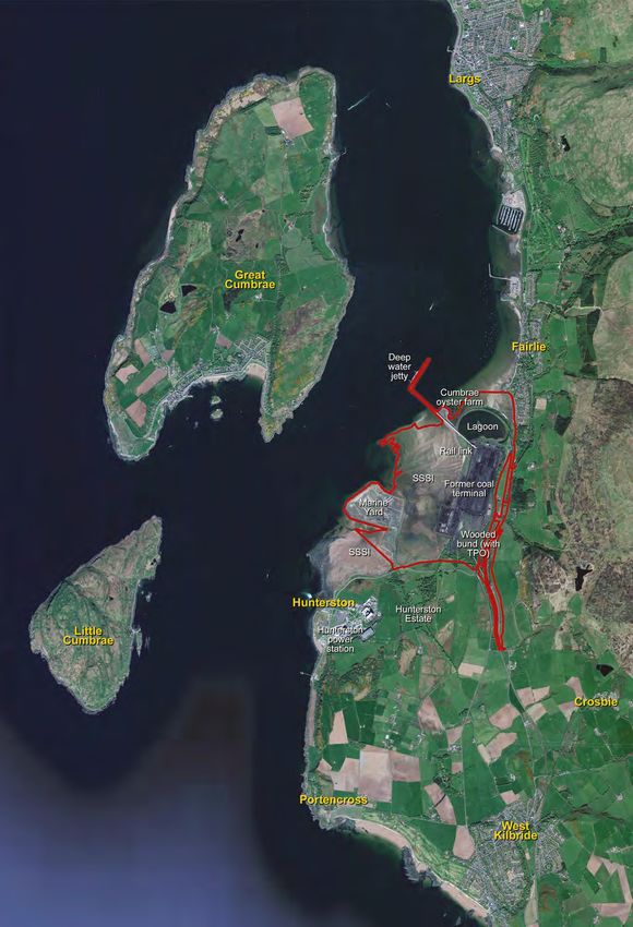
1. Introduction
      Alignment                                                   It is intended to use natural capital accounting process
                                                                  as part of the wider strategic thinking linked to
                                                                  environmental considerations for the Framework and
      The Framework will be mindful to be aligned with the        subsequent projects. The natural capital accounting
      overall strategic aspirations across the wider identified   process is not intended to duplicate regulatory processes
      Hunterston area (Local Development Plan2), which            that will remain required as defined by legal provisions,
      includes the PARC site, which is currently being            but there will be an interface which will be considered.
      formulated by the North Ayrshire Council’s working
      group. It is intended that Hunterston PARC will adhere      Interested parties are asked to consider this
      to the emerging thinking for the site regarding inward      framework and respond to the following key
      investment innovation such as the capacity in blue,         question: Do you have any views on the proposed
      green and circular economy sectors and overall in           development framework or range of uses at
      assisting and providing a platform for supporting           Hunterston PARC?
      Ayrshire Growth Deal investment.

      Whilst this Framework will be ahead of this process, it
      is not envisaged that material changes will be required
      to the Hunterston PARC Framework once the Strategic
      aspirations are formalised, however this will be kept
      under review to ensure it can comprehensively support
      Ayrshire Growth Deal project activity.
                                                                                                                              CGI

Currently
2. Consultation Purpose
What is the purpose of this
consultation process?
The consultation process provides the opportunity to share your views
on the proposed development framework uses on the Hunterston PARC
site, to follow on from the consultation upon the Master Plan in May
2019.

How do I comment on the proposal?
Comments can be submitted via the following email address:
HunterstonParc@peelports.com from the 1st September until the 30th
September 2021.

What will happen to my comments?
Your comments will be kept confidential and will not be attributed
to individuals. All comments will be collated and considered by the
Hunterston design team in future development. A consultation report
will be prepared. This will summarise the output of the consultation and
where changes have and have not been made and provide reasons why.

Will there be further opportunity
to comment on the proposal?
There will be additional opportunities to comment on more detailed
proposals as planning applications are submitted for individual parts
of the site. This will occur after we seek approval of this Development

 Images right: CGI’s of potential future developments
3. Site Analysis and Context
History & Context of Hunterston                             there providing many skilled and unskilled roles to
                                                            support the communities in the locality. There is a strong
Hunterston has a rich history, as a safe harbour, a Port,   community spirit longstanding within Fairlie, with many
and as part of the wider area of two nuclear power          residents very proud of the area in which they live and
stations and the historic Hunterston Estate, to the         work.
South, granted to the Hunters by David I of Scotland in
the 12th century, with the heads of the clan having lived   Hunterston was a very busy coal import terminal,
on the estate for the last 900 years.                       importing product from the Americas predominantly to
                                                            service the Power stations at Longannet and further
Reference to the longevity of the Hunters was made in       afield, mainly by rail.
the opening of the terminal in 1979 with the presentation
of a symbolic coin to the Queen, for payment of rent for    Although the importation of Coal is no longer conducted
the lands at Hunterston.                                    (since 2016) the site is still irrevocably a well-designed
                                                            and connected place.
The coastline has offered such advantage that its
strategic position has provided opportunity for the         The rail heads are still in use by EDF, for the safe and
development of energy related services which have           reliable movement of flasks from Hunterston B, with
benefitted the UK as a whole.                               this becoming more frequent over the next few years
                                                            whist the site is de-fuelling and being decommissioned.
The 20th Century saw the development of Hunterston          We will work very closely with EDF to ensure that this
A and B nuclear power stations and the development          relationship is continued and brought closer as we
of Hunterston as an import terminal to service the          support them in this nationally important phase.
production of British Steel at Ravenscraig. This,
undoubtably changed the fortunes of those that worked
                                                            From 2008-2012, the site was considered for a coal           OS Plan 1911. Reproduced with the permission of the National Library of Scotland
                                                            powered power station with Peel Energy and DONG
                                                            Energy promoting this as Ayrshire Power. The company
                                                            proposed the Hunterston Power Station, a 1600
                                                            megawatt coal-fired power station in Scotland.

                                                            This was heavily opposed by local and national interests
                                                            who didn’t want a new coal powered station given the
                                                            evidence of the release of carbon into the atmosphere,
                                                            even with a carbon capture element that was proposed
                                                            to reduce this extensively.

                                                            The scheme would have also required to have used
                                                            some of the SSSI to accommodate the scheme. Peel
                                                            Energy withdrew the proposals and the scheme did
                                                            not progress. Hunterston continued to be a coal import
                                                            terminal until its closure in 2016 with the direct loss of
                                                            130 jobs.

                                                                                                                         OS Plan 1980 - 1987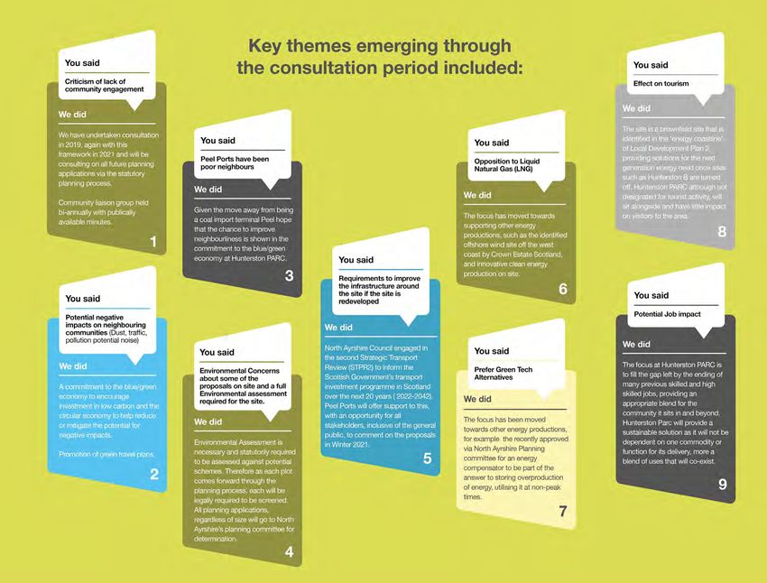
3. Site Analysis and Context
Fairlie                                                     times since 1998 and celebrates the home and waters of
                                                            these magnificent sailing boats.
Fairlie began as a fishing village providing good,
sheltered anchorage that was fully used in the 16th         To the North of Fairlie are the Kelburn lands, with a fine
century. A turnpike road was built from Greenock to         castle, where members of the Boyville (Boyle) family
Stranraer in the 18th century and merchants and master      have been since the 12th century. David Boyle was
mariners began to move into Fairlie.                        honoured in 1703 by being created ‘Viscount Kelburn’
                                                            and ‘Earl of Glasgow’. One of the later Earls, in 1850,
The channel between Fairlie and Cumbrae (Fairlie Roads)     had a wall built round the estate to give work to the poor
was a popular anchorage for merchant shipping, mainly       people of the area with the present Earl greatly improving
to avoid the dangers of press-gangs at Greenock and the     and developing the estate for the 21st century via new
customs could be easier avoided if anchored at Fairlie.     initiatives.

It was in the late 18th century that John Fyfe came from    It is now a country centre, open to the public, and
Kilbirnie to set up business as a cartwright in Fairlie.    attracts many visitors from far and wide. Four of the
                                                            world’s leading graffiti artists created a unique, colourful
His son William (1785–1865) founded the Fife & Son          art work on the south side of the castle in an graffiti art
shipyard in Fairlie in 1803 to which William’s grandson     project with the style hailing from Brazil. It received huge
William Fife III (1857–1944) brought international          media coverage given that the property is a historic rural
recognition as a prolific designer and builder of sailing   category A listed castle.
yachts on the beachfront of Fairlie, this became known
as the ‘Fife Dynasty’, these three generations of boat      In 2011, the mural was named as one of the world’s top
building by William Fife’s I,II,III produced are coveted,   10 examples of street art by author and designer Tristan
with the large and now rare racing yachts selling in        Manco – on a par with Banksy’s work in Los Angeles and
excess of £2 million. The Fife regatta has been held five   the Favela Morro Da Providencia in Rio de Janeiro.

                                                                                                                           Image: MoonBeam, William Fife III, Photograph By Ludovic Péron - Own work, CC BY-SA 3.0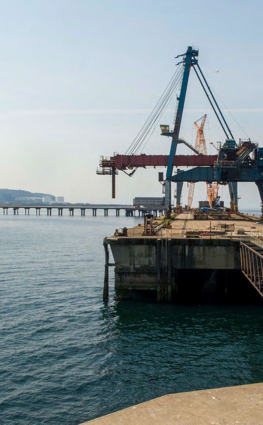
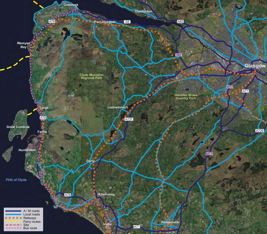
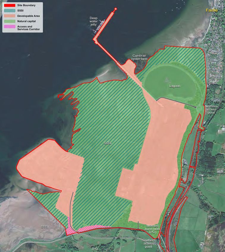
4. Location
The proposed site is located at Hunterston, 320-acres       national importance as an energy hub and deep-water
of brownfield development land owned by Peel Ports          port are recognised.
Group following the purchase of Clydeport’s portfolio in
2003.                                                       Employment Site in the Regional Economic Strategy and
                                                            Local Development Plan 2 as a Port and Energy Hub,
The site is bounded to the south and east by a large,       Strategic Development Area 1.
purpose built bund which has an extensive Tree
Preservation Order on it. This provides excellent           North Ayrshire, Peel Ports and Scottish Enterprise
screening to the previous iterations of the site and        support the designation of Hunterston as a National
now provides a healthy biodiverse area, low on human        Development in National Planning Framework (NPF4)
interference. Beyond this to the south is Hunterston        which is currently under preparation.
Estate, with the Castle built in 1263, and the Mansion
House started in 1799 and comprising of 72 rooms.           Hunterston PARC is one of 10 national and internationally
and still in the ownership of the original family the       important investment sites within the Scottish
Hunters. It has been used extensively as a filming          Government’s Green Investment Portfolio, and is
location since the 1990s.                                   nationally recognised.

The Nuclear power stations A and B beyond that, one
in long term decommissioning and the other, B about
to be decommissioned. To the north of the site is a
purpose built lagoon and bird sanctuary which also
provides extensive habitat for a wide range of birds
such as Heron, Wigeon, Greenshank, Goldeneye and
Dunlin.

The principal former use of the site was as an import
iron ore and coal terminal to service Ravenscraig
Steelworks station and Longannet Power Station.
Hunterston has been largely vacant since 2016, with
Cumbrae Oysters and EDF still in occupation.

Given its size, condition and central location, the
positive development of the site will make a huge
contribution to the regeneration of the area, both
economically and physically. Hunterston forms part
of the energy coastline and is part of a unique identity
and character. The site is intrinsically connected to
Fairlie and Largs to the North and Seamill to the South
therefore development of this scale in this area will
have benefits for the wider area.

There are opportunities for attracting a greater number
of employees, new residents and commuters from
outwith the area, with people drawn to the improved
and redesigned facilities and the opportunity for jobs in
a world class setting.

Hunterston is recognised in the National Renewables
Infrastructure Plan (NRIP) site (Area of co-ordinated
action) and as a key port. North Ayrshire Council have
identified Hunterston as a ‘Strategic Development Area
in Local Development Plan 2 (LDP2) where strategic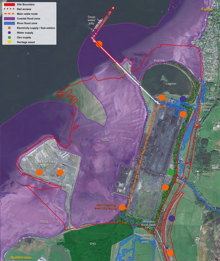
5. Consultation to Date
Pre-Engagement Activity
In April 2019, stakeholders were informed that there was
an intention to bring forward a Concept Masterplan for
the Hunterston site, and that a series of consultation
events were arranged, an email address and website
were set up for people to comment, a letter drop and
a council meeting was organised to inform the local
council representatives of our intention to undertake a
public consultation.

Consultation
The consultation was held over a six week period from
16th May to the 28th June 2019 with public consultation
held in two different locations of Millport and Fairlie.

The findings from this were published in a consultation
report in February 2020 which provide a comprehensive
grouping of thoughts, comments and proposals for the
site. Right is a summation of the most discussed and
raised points.

Of the 145 online and written responses that were
received in response to the survey were residents
predominantly. More than half of the respondents (54%)
felt the redevelopment of Hunterston is important to the
local economy.
6. Connectivity
Introduction
Hunterston PARC is able to absorb the majority of movements via multi-
modality given the good connections to, an on-site rail head, railway
sidings, the road network, and a jetty capable of hosting Cape Size
vessels. Detailed Transport Statements will be developed and submitted
with future planning applications, potentially offering mitigation and
enhancements if identified for the scheme through the development
phase and then assessed by statutory consultees such as Transport
Scotland.

This section sets out key transport and connectivity issues which have
informed the development framework.

Wider Connections
Transport Scotland is currently considering the future of roads, trains and
cycle paths in Ayrshire over the next 20 years with the agency presenting
138 potential ideas for investment across the region which Hunterston will be
part of. The options are being weighed up as part of the strategic transport
projects review (STPR2) and comments are sought in the winter of 2021.

Within the region, the most likely impact on the network once Hunterston
is productive is that it has the potential to affect traffic flows on the A78
and A737 with increased traffic movements. Both of these roads have been
identified as requiring ‘Corridor Improvements’ by STPR2. North Ayrshire
Council have responded to STPR2 (March 2021) which expanded on this
issue:

‘…access to Hunterston which has been identified within the
National Planning Framework as a key deep-water resource
with significant potential to support both transport and energy
sectors. The NPF acknowledges the need to support a National
Development at Hunterston with infrastructure improvement, in
particular the A78/A737.

It would help to meet both national and local development
aspirations by providing an upgraded link between the A78 and
A737 strategic routes. Substantial resources are being invested
in both Hunterston and Ardrossan through the Ayrshire Growth
Deal, with £18m secured for the Centre for Research into Low
Carbon Energy and the Circular Economy at Hunterston…it
would reduce journey times, reduce accident rates and provide a
more direct route between North Ayrshire and the M8.’
6. Connectivity
Peel Ports commits to supporting North Ayrshire
Council in their identification and bidding for funding
traffic throughout the whole land footprint rather than
concentrating it at one location.
policy 7 of the LDP2, which allows non-industrial uses
within Business and Industry employment locations
Neighbourhood Connections
from UK government for nationally identified roads such as Hunterston to provide ancillary services.
The site stands in isolation and was purposefully
needing ‘infrastructure improvements’. Any As the primary connections are already in place the
designed in this manner, but this does not mean that it
improvements to these roads would align with the secondary connections will be defined and planning There will be clear active internal travel connections
is closed. Peel Ports intend to open some of the site to
nationally identified need to help promote economic permission and advice from North Ayrshire Council will running north - south and east - west throughout the
use for footpaths and provide additional connections to
growth and the enablers required to do this in a be sought. site. These will connect the development with existing
existing networks.
sustainable manner and in the case of North Ayrshire residential neighbourhoods, cycle routes, local bus and
within the context of the Ayrshire Growth Deal. Tertiary connections which could include cycle train services.
As the rail network is still functioning and providing ways and footpaths will be enhanced or protected
service to a third party at present Peel is able to and in from development if they are deemed essential to The Cycleways and footpaths will allow for local Parking for the Area
line with Peel’s commitment to multi-modality absorb, biodiversity. residents and commuters to take alternative modes
grow and develop any haulage that is rail compatible of transport to travel to and from the site for work or The development will incorporate an innovation
from the redevelopment of Hunterston PARC. Hunterston PARC offers an opportunity to create a safe leisure. On site encouragement of multi-modal choices park with current parking layout re-utilised. Parking
campus style setting offering unparalleled views along to commute could come from a green travel plan, staff associated with the Port, Industry and Marine Yard and
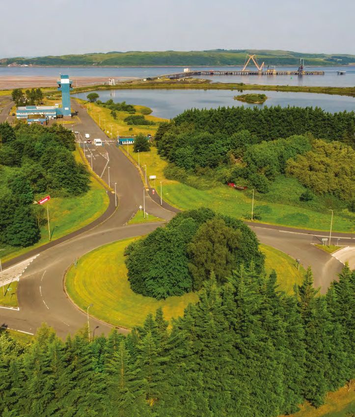
The Jetty in recent years has seen huge change, with a beautiful stretch of the coastline. Along with well- schemes to purchase bicycles and incentives for staff to commercial uses can also be accommodated on site
the removal of the cranes and the conveyor belt, it is established footpaths and a cycleway it offers multi- travel together if arriving at the PARC by vehicle. easily.
now available for many other types of vessels to access modality to and from the site for all users.
the site. Future schemes could include specialised The proposal scheme for Hunterston PARC provides
vessels for offshore cable laying which would allow The development of the site is to embrace these an existing and well-designed important site with
manufacture and distribution from site to vessel without potential connections and utilisation of the site by the internationally important infrastructure, and connections
using the national road network increasing multi-modal local community to access services on site, such as a creating a destination site for the Ayrshire area and
usage on site. petrol station or a coffee shop, which are compliant with beyond.
Peel Ports predominantly is a Port operator with the
overall objective to maximise port usage. However, we
acknowledge that the offer of ‘choice’ via multi-modality
is necessary to promote modal shift. Therefore, Peel
Ports commit to maintaining the internal rail network,
the jetty and to maintain the on-site approaches to the
A78. Peel Ports will be able to contribute positively to
transportation methods by offering this.
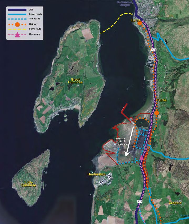
Routes and connections
The principal means of access into Hunterston is via
vehicle from the A78, there is a well serviced train and
bus link travelling north to Largs and south to Irvine and
Glasgow in the east.
The development framework considers the long-
established accesses to the north and south of the
site and consideration will be given to the internal
development of the site to create smooth traffic flow
on and off site. The development will require multiple
on-site estate roads connected via a spine road which
will then seamlessly connect to the wider existing
road network. This approach reduces the impact on
surrounding neighbourhoods by distributing the7. Policy Context
Strategically located port NPF4
Hunterston PARC is able to serve a variety of The emerging National Planning Framework (NPF) is a
different businesses, facilitating the import and/ long term plan for Scotland (to 2050) that sets out where
or export of goods from Scotland to the rest of the development and infrastructure is needed to support
world. sustainable and inclusive growth. NPF4 will incorporate
Scottish Planning Policy (SPP) which contains detailed
Our extensive 450m main outward jetty length, helipad national policy on a number of planning topics. For the
and 36m draught is unparalleled in the UK and allows first time, spatial and thematic planning policies will be
vessels to be accommodated alongside with ease and addressed in one place, and will have the status of the
simplicity. development plan for planning purposes. NPF4 will also
take into account regional spatial strategies which will
The ability to approach the terminal’s jetty negates be prepared by local authorities.
extensive manoeuvring and in suitable conditions
would also render tugs unnecessary for most vessel
movements. It offers importers and exporters
opportunities to deploy the biggest carriers all National Renewables
connected by excellent road and onsite rail links.
Infrastructure Plan 2014
The objective of the national renewables infrastructure
plan is to make sure that appropriate sites are available
Scotland’s National Planning in the right locations to provide the platform for the
Framework 3 (2014) growth of industry. It states that having the right
locations for the industry is critical if Scotland is to
Ambition. Opportunity. Place become a home for the offshore renewables supply
chain. Hunterston is acknowledged within this plan as
The National Planning Framework 3 (NPF3) sets the possessing the potential for large scale manufacturing,
context for development planning in Scotland and assembly and fabrication operations.
provides a framework for the spatial development
of Scotland until the publishing of NPF4 which is
expected to be adopted in 2022. The NPF identifies
national developments and other strategically important Regional Spatial Strategy
development opportunities in Scotland, where
Hunterston has long been identified as a priority for Regional Spatial Strategies (RSS) are long-term spatial
industrial and employment use. strategies which specify the area/s to which they
relate, and identify the need for strategic development,
the outcomes to which strategic development will
contribute, priorities for the delivery of strategic
development, proposed locations which are to be
shown in the form of a map or diagram.7. Policy Context
North Ayrshires Local Permitted Development Part 13 Class 37: such as traffic, noise, landscape and visual will be
expected with most of the future planning applications
Development Plan 2: 2019 Dredgings (dependent on factors such as job numbers and size of
There are instances whereby operations development).
The Local Plan sets out how North Ayrshire Council at Hunterston Parc are dependent upon This class permits the use of any land for the spreading
aim to guide development and investment in the implementation of development projects that entail of dredged material by those statutory undertakers
area over the next 20 years. some form of reconfiguration in layout and/or listed in Class B above. Whilst much of marine
the erection of buildings. Under the terms of The dredging are deposited offshore rather than on land.
Hunterston is identified as a Strategic Project in Town and Country Planning (General Permitted The incidence of dredging and deposition is of regular Residential Amenity
recognition of the national importance of Hunterston Development) (Scotland) Order 1992 Hunterston occurrence and as such the rights enjoyed under Class Residential amenity will be considered at each planning
as an energy hub and a deep-water port. PARC benefits from several concessions such that D are of critical operational importance. application as it is a material consideration. However,
there is no necessity to apply for formal planning we would expect that any applications on site would
permission as follows: minimise their impact in potential areas such as noise,
Potential Planning dust, odour and traffic by providing relevant mitigation
should it be deemed to be required through planning
Considerations for future assessment.
Part 13 Class 35: developments on Hunterston
Development by Statutory Undertakers in respect of PARC
Dock, pier, harbour, water transport, canal or inland
undertakings Visual Amenity/ Views and Vistas
Consideration of potential visual impact will be
This class permits development upon our operational
land as undertakers and by our lessees, for shipping
Scale & Form considered by the virtue of scale, massing and siting on
Hunterston PARC through the planning process.
and for dock, pier or harbour related activities (for The proposed development will acknowledge and
passengers, livestock or goods), or connected with the respond to the existing physical context. The setting The maximising of opportunities for views from and to
movement of traffic by canal or inland navigation, or any of the site with its purpose built bund and planted tree the site will be key to the ‘campus feel’ and providing
railway forming part of the undertaking. screening, the two Nuclear power stations to the south a nice place to work. Therefore encouragement will be
and hilly landscapes to the east all offer a strong setting given to future occupiers to consider the orientation
The availability of the rights is significant in terms of our and edge for the majority of the site, which industry of buildings and windows to take best advantage of
operational port requirements. For example, there are sites within. the setting, we will provide ‘design principles’ in a
often scenarios whereby buildings, are required at short document produced as a result of this framework.
notice for the safe and weatherproof storage of import The Island of Great Cumbrae to the west as a receptor
or export cargoes. with the village of Fairlie to the north is a combination In it we will expect an adherence to the design
of housing with 19th and early 20th century buildings in principles on the blue/green campus, which will be most
It is of course acknowledged that where such Fairlie of a linear community. prevalent to the north of the site where the Research
projects are likely to result in significant environmental and Development Campus will be sited.
effects, the Class B rights are overridden such that Housing generally on the outskirts and on the seashore
an Environmental Statement would be required in are set within their own grounds and well screened from
association with a formal planning application. Likewise, the road to the east with views over to and from Great
we are mindful of relationships with local planning Cumbrae in the west. The development of the PARC
authorities and those third parties potentially affected will take these receptors into account and inform future
in our exercising of these rights. For this reason, planning applications for development.
the Port actively engages and consults with Council
representatives and any local residents that may reside We would expect that due to the proximity of Fairlie
in close proximity prior to undertaking any development Village all future proposals will undertake a thorough
works. assessment of this potentially sensitive receptor with
regards to increases in activity at Hunterston PARC.
Therefore it will be typical that assessments in areas8. Site Conditions
Overview Infiltration is generally the preferred method for
discharging surface water, as this mimics the behaviour
The development of the site requires to consider of the natural landscape. Practically, it also removes
site conditions, reflective of the history of the site the requirement for a discharge pathway beyond the
and the uses it has accommodated. These site footprint of the site and the potential need for discharge
conditions are considered as follows: consent licensing. Infiltration is typically achieved
using soakaways (for smaller collection catchments),
infiltration trenches or infiltration basins, as well as
Flooding and Site Drainage infiltration-type pervious pavement designs.
The requirements for the design of surface water The viability of infiltration is primarily dependent upon
drainage for the site are set out in North Ayrshire the subsurface permeability of the soil on site and depth
Council’s Drainage, Sustainable Urban Drainage to groundwater, although contaminant mobilisation
Systems & Flooding: and ground stability risks must also be considered.
Site investigations undertaken in 2009 indicate that the
Procedure Note For Prospective Developers (2019) site area is predominantly underlain by sand or coarser
and SEPA’s Regulatory Method for Sustainable Urban textured materials that would be expected to have high
Drainage Systems (WAT-RM-08; 2019), with the permeability.
overarching drivers being the control of pollution and
flood risk from site discharge. The same investigation determined that groundwater
was generally at least 2 m below ground level, with
Pollution control is achieved by the design and smaller local areas of perching to shallower depths,
implementation of an appropriate SuDS treatment train with water quality sampling from perched groundwater
(consisting of one or more SuDS elements in series) locations returning some instances of cadmium, copper,
complying with the Simple Index Approach as described chromium and lead exceeding marine environmental
in the CIRIA SuDS Manual (2015), with exception of high quality standards (EQS), and more limited instances
pollution hazard developments (e.g. lorry yards, sites of contamination found in soil samples. While the
where waste, chemicals or fuels are handled/managed/ site’s physical characteristics are broadly suitable
used/manufactured, and other industrial sites) which for infiltration SuDS, this should be supported by
also require SEPA consultation and CAR licensing. ground investigation to ensure that local subsurface
permeability is sufficient (determined through BRE-
Flood risk control is generally achieved by ensuring that compliant infiltration testing), that the local depth to
peak rates and cumulative volumes of site runoff do not groundwater is sufficiently deep and that the location
exceed equivalent pre-development amounts, although of the infiltration SuDS is not near to locations of
exceptions to this requirement apply for discharge to contaminated perched groundwaters.
transitional or coastal waters due to high dilution.
If additional water quality treatment is required based on
Options for surface water drainage can be categorised the pollution hazard of the intended land use, infiltration
in terms of discharge pathway, with the following SuDS may be used at the downstream end of a SuDS
options available in order of general preference: treatment train with other SuDS elements providing
source control treatment and/or in-line treatment.
1. Discharge via infiltration Source control SuDS may include green roofs, rainwater
harvesting (e.g. rainwater butts), permeable paving, filter
2. Discharge to coastal waters trenches and rain gardens. Conveyance between source
3. Discharge to watercourse control measures and end-of-line infiltration SuDS may
4. Discharge to sewers be provided by swales, which provide in-line water
quality treatment, or else by conventional pipework or
channels.8. Site Conditions
Where local subsurface permeability is not sufficient for historical site drainage system, which outfalls beyond
a full infiltration solution, infiltration may still be used the SSSI.
(subject to the considerations set out above) to assist in
the discharge of surface water drainage, but remaining For areas of the site in close proximity to the Burn
water will need to be drained laterally – preferably Gill, discharge to this transitional watercourse may be
to another location with more favourable infiltration a viable alternative to coastal discharge. Discharge
characteristics, but otherwise to a receiving waterbody to transitional waters requires only minimal SuDS
or sewer. Likewise, if there are any extensive areas treatment, provided by source control SuDS or a short
of the site found to have low subsurface permeability length of swale or filter trench.
or groundwater perching or contamination concerns,
all surface runoff must be discharged to a receiving The site is located in an area that may be at risk of
waterbody or sewer. coastal flooding, exacerbated by wave impact. The
present-day 1 in 200 year still water extreme sea level
Suitable SuDS will vary depending upon context, with is 3.67 mAOD, with sea level rise due to climate change
rainwater harvesting, rain gardens and permeable predicted to increase this to 4.25 mAOD by 2080. The
paving preferred in residential and commercial areas risk of SuDS elements flooding due to tidal action and
and linear features such as swales (or enhanced swales/ waves should be considered in the siting and design of
bioswales) preferred adjacent to the verges of arterial SuDS, with SuDS located on high ground and/or behind
roads and through roads. Where design constraints high intervening ground if possible. Flood risk posed by
permit, the preference is to keep surface water at the Burn Gill should similar be considered for any SuDS
the surface wherever possible, using swales and placed near to this watercourse.
channels in preference to pipes. However, pipes may
be necessary to cross roads along the discharge route Regardless of the SuDS treatment train used, it is highly
and to overcome unfavourable gradients and other recommended that site drainage design incorporates
constraints. In areas with contaminated soils or perched appropriate pre-treatment to remove sediment and silt
groundwater, it may be necessary to line SuDS features prior to discharge into the SuDS; this minimises the risk
to minimise the risk of contaminant mobilisation; of progressive blockage of substrate material within the
otherwise, SuDS should be unlined to allow infiltration- SuDS (termed “blinding”) that may reduce infiltration
assisted discharge. performance over time and/or increase maintenance
requirements for the SuDS. Oil separation may similarly
Discharge to sewers should only be considered as a last be necessary as part of pre-treatment for SuDS systems
resort, and is subject to Scottish Water consent, with serving surfaces with high oil contamination risk, such
stringent restrictions applied to surface water and in as lorry parking areas, high-traffic lorry approaches and
particular combined sewer discharge. Therefore, where industrial areas.
infiltration is not feasible, the preference is to discharge
to a waterbody.
Discharge of surface water to coastal waters results in
substantial dilution and therefore does not generally
pose pollution or flood risk concerns, such that SuDS
are not compulsory for coastal discharge. However,
the coastal waters adjacent to the site are within the
Southannan Sand SSSI site, such that NatureScot
(formerly Scottish Natural Heritage) must be consulted
if any SuDS are designed to discharge via new outfall
to coastal waters, with SEPA licensing required for any
new outfall above mean high water springs (MHWS)
level and Marine Scotland licensing needed for any
new outfall below MHWS. If feasible, coastal discharge
should therefore instead be routed along the causeway
route to the large holding tanks associated with the8. Site Conditions
Climate Change Contaminated Land 1. The use is a necessary part of the planned
works.
The existing Flood Risk Management Strategy for An important consideration in the development of many 2. The material is suitable for that use.
the Ayrshire Local Plan District, which is relevant to projects concerns the likelihood of contamination of 3. The material does not require any processing or
the Hunterston PARC Master Plan area, is based on development sites. Soil/land may inadvertently become treatment before it is reused.
the 2018 climate change projections which provides contaminated through various activities and operations.
updated observations and projections to 2100 in the UK 4. No more than the quantity necessary is used.
and globally. The impact of these amended projections Of relevance to port activities, cargo handling and
would be considered in terms of potential future storage may cause run-off, spills or leakage in 5. The use of the material is not a mere possibility
flood risk. As a matter of good practice, any future operational areas. In addition, the historical use of sites but a certainty.
development taking place in the PARC should ensure acquired for development purposes are equally as
6. The use of the soil will not result in pollution of
that its constituent elements are climate resilient and important to assess.
the environment or harm to human health.
use low carbon technologies.
Hunterston PARC is continuing to improve its site
The NPF4 Position Statement notes a significant shift is through remediation, ensuring that there is a prevention The remediation plan needs to be agreed with the Local
required to achieve net-zero emissions by 2045 and that of contamination, and the raising of awareness of Authority as part of a formal planning application.
we all cannot afford to compromise on climate change. compliance with all environmental regulations. We seek
North Ayrshire therefore pro-actively sought cabinet to produce a desktop remediation strategy, that would
approval in May 2021 for the proposed Environmental inform future occupiers when applying for planning
Sustainability and Climate Change Strategy 2021-2023 permission.
with recommendations that a Climate Change Steering
Group is established. Peel Ports have expressed interest These planning applications submitted to North Ayrshire
in being a member of this Group going forward. Council would be expected to be accompanied by a
desktop study covering a historical assessment of past
The site is being promoted as a hub for the blue and site usage.
green economies. Hunterston PARC’s vision is to bring
together energy intensive industries with low cost, In certain circumstances, intrusive site investigation
on-site power and heat generation, offering a unique surveys and remediation strategies would be
opportunity to develop innovative, self-sustaining and undertaken and the outcomes submitted for assessment
cost-effective net zero operations aimed at supporting and approval either as part of a planning application or
the delivery of Scotland’s 2045 climate change targets. in compliance with a planning condition attached to a
The site should be seen as an enabler to meeting the consent.
2045 targets as the sorts of companies being attracted
to the site are part of the journey. Peel Ports are currently producing a desktop
remediation strategy which will form part of this
framework. This is being undertaken by Envirocentre
who have had a long history of studies and surveys on
Hunterston PARC site.
It is worth noting that this strategy has to meet criteria
set out below by SEPA (Scottish Environment Protection
Agency) who will not regulate under the waste regime
unless a remediation plan is in place incorporating the
six criteria listed below:8. Site Conditions
Biodiversity area designated or proposed under the Birds and/or
Habitats Directives (European sites) and/or the Ramsar
Southannan Sands SSSI extends for over 4km along
the coast, and is subdivided by Hunterston PARC. The Other nearby designations include Portencross Woods
Convention (Ramsar sites), the requirements of The marine construction yard and the coal terminal conveyor SSSI, which is of national importance for its ancient
The Hunterston PARC Master Plan area is located Conservation of Habitats and Species Regulations 2017 extend beyond the Mean Low Water Spring (MLWS) coastal mixed ash woodland, situated on steep-sided
within the mouth of the Firth of Clyde. This location (the Habitats Regulations) may apply. tide mark and sub-divide the sandflats and mudflats maritime cliffs ; Kames Bay SSSI, a small sandy bay
is such that operations at Hunterston PARC co-exist into three areas: Hunterston Sands, Southannan Sands with rocky margins provides a feeding ground for wader
with a number of nature conservation sites of national The nearest Special Protection Area (SPA) site is and Fairlie Sands. Areas of the nationally scarce dwarf species. Ballochmartin Bay SSSI is backed by herb-
importance. Renfrewshire Heights, located approximately 12km eelgrass (Zostera noltii) are a biologically and structurally rich grassland and roadside verges which support
north-east from Hunterston. This site is designated for important component across this site. Although not slow-worms and a number of uncommon higher plant
The spatial distribution of the nationally designated terrestrial qualifying interest features. In addition to the notified features of the site, the sandflats and mudflats species.
nature conservation sites within 5km is illustrated in table below, the nearest marine designated site is the are a food source for a range of wildfowl and waders
the table below. The relevant designations are Sites of Inner Clyde SPA, Ramsar and SSSI site, located more species, particularly during the winter months, with There are no nature conservation sites designated for
Special Scientific Interest (SSSI) which are protected than 25km to the north-east. The Cumbrae Islands lie communities of polychaetes (marine annelid worms marine mammals or basking sharks in the immediate
areas under the Wildlife and Countryside Act 1981 for approximately 2km north west of Hunterston and are such as lugworms), crustaceans (including species of vicinity of Hunterston. However, species of marine
the protection and conservation of flora and fauna. covered by a Marine Consultation Area. crab and shrimp) and molluscs (such as mussels and mammal and basking sharks have been recorded in and
Under the Nature Conservation (Scotland) Act 2004, cockles) present, especially on the lower shores (SNH, around the Firth of Clyde. The Clyde Marine Mammal
NatureScot (the statutory nature conservation body) The Marine (Scotland) Act 2010 provides for the 2018). Project documents sightings of marine mammals
is responsible for monitoring the condition of these designation of Marine Protected Areas (MPA) in Scottish (and basking sharks) in the Clyde, and is undertaking
protected areas and advising on development proposals inshore waters (within 12 nautical miles (nm) of the a visual and acoustic marine mammal survey of the
that have the potential to affect protected areas. territorial baseline) to protect habitats and species When the Hunterston Ore Terminal was built between Clyde waters. A summary of the Clyde Marine Mammal
considered to be of national importance. Hunterston 1974 and 1979, a lagoon and a bird sanctuary island Project’s records for 2017 (the latest available) is
Where a project is located close to, or within, an PARC is over 10km from the nearest MPA. was developed to the north. provided in the table below.
Nature conservation designated sites within 5km
Biodiversity Site Designation Distance & direction Description
from Hunterston
Species Comments
Southannan Sands SSSI 0km Intertidal sandflats
Harbour porpoise (Phocoena phocoena) Most commonly identified cetacean species in the Clyde and is Extensive intertidal sandflats
resident throughout the year. In 2017, recorded between February habitat, with areas of the
and May adjacent to Hunterston nationally scarce dwarf
Coal Terminal. eelgrass species.
Short beaked common dolphin In 2017, recorded between February and May adjacent to Portencross Woods SSSI 1.5km south Upland mixed ash woodland
(Delphinus delphis) Hunterston Construction Yard and Hunterston Coal Terminal Botanically-rich mixed
and along the Hunterston and Fairlie Channels to the North. deciduous woodland is situated
on steep-sided maritime cliffs.
Basking shark (Cetorhinus maximus) Often appears in summer months in the Clyde, with numerous Ballochmartin Bay SSSI 1.5km north Coastland
records in the waters around Great Cumbrae to the North. The beach is backed by herb-
rich grassland and roadside
verges supporting slow-worms
Grey seal (Halichoerus grypus) There is a small haul-out for grey seal on The Eileans in Millport
and a number of uncommon
Bay and they can be observed from shore.
higher plant species.
Kames Bay SSSI 2 km north-west 2 km north-west Coastland
Harbour seal (Phoca vitulina) There is a small haul-out for harbour seal on The Eileans in Millport Most intensively studied site
Bay and they can be observed from shore. for intertidal marine biology
in Scotland.8. Site Conditions
To the north of the Hunterston PARC Master Plan area,
an area of Southannan Sands, Fairlie, is designated
policy stipulated within the Scottish Planning Policy
(2014) (The Scottish Government, 2014).
Heritage
as a Shellfish Water under the Water Environment
(Shellfish Water Protected Areas Designation) (Scotland) We have engaged with a third party to review the There is one heritage asset within the Hunterston
Order 2013. Fairlie Shellfish Waters is also designated biodiversity on site and provide recommendations PARC Master Plan area; Hunterston Gate (North Pillars)
as a Shellfish Harvesting Area by the Food Standards for site management going forward. We will also (LB14314), which is registered as a Listed Building.
Scotland (FSS), for the production of Pacific oysters be developing some recommendations for those The designation of a building or structure of special
(Crassostrea gigas). Fisheries landings in the area developing on site on how they can integrate elements architectural or historic interest is recognised through
are dominated by shellfish, with the large majority of into their design to complement the wider site. This is the Planning (Listed Buildings and Conservation Areas)
landings for Nephrops, but scallops, crabs and razor likely to include recommendations on plants, SuDS, (Scotland) Act 1997.
clams are also present in large numbers. habitat creation (bird/bat boxes etc), orientation and
style and consideration for the dark skies / low impact Built around 1800, Hunterston Gate (North Pillars) is
Key fisheries within the Firth of Clyde also include lighting etc. For example these will include: described by Historic Environment Scotland (HES)
herring and sprat. The Clyde is identified as as “square, rusticated, stone piers with dentilled
highintensity nursery grounds for cod, hake, ling, • Enhancing the site for existing species such as entablatures; urn finials decorated with shell ornament;
mackerel, herring and spurdog (Coull et al.,1998). breeding birds and mammals. low curved screen walls and smaller terminal piers.”
(HES, 2018)
In many cases, development of existing land within the • Development of SUDs solutions that use more
Hunterston PARC Master Plan area is unlikely to have natural open drainage, rainwater ponds, road Nearby heritage assets directly to the south include
any significant impact upon biodiversity, given that it will verge water capture, etc to support natural Hunterston Castle (LB14313) and its associated
effectively involve the re-use or development of existing solutions. buildings, comprising Walled Garden, Hunterston
brownfield sites. However, this would be considered on (LB14288), Hunterston House (LB14286) and Well in
a project-by-project basis and would be informed by • Integration of local natural species and habitat Front of Mansion (LB14287). All assets are located out
site-specific surveys and assessments as appropriate. within the infrastructure, such as creation of with the boundary of Hunterston PARC
corridors into parking and building surrounds.
Any construction works below the MHWS tide level These provide important links between existing
would require a Marine Licence under the Marine and new habitat.
(Scotland) Act 2010, to be granted by Marine Scotland.
For works above the MHWS tide level, planning • Creation of nature based outdoor spaces
permission may need to be sought from North Ayrshire for company personnel outside and around
Council under Section 28 of the Town and Country industrial units.
Planning (Scotland) Act 1997. This process would •
involve close liaison with stakeholders, including • Building solutions into built infrastructure
NatureScot and Scottish Environment Protection including bird and bat boxes, bee and insect
Agency (SEPA). feeding, green walls and roofs, water and solar
energy capture, etc.
For developments that may give rise to significant
environmental impact, an Environmental Impact
Assessment (EIA), under the Town and Country Planning
(EIA) (Scotland) Regulations 2017 for terrestrial projects,
or the Marine Works (EIA) (Scotland) Regulations 2017
for marine projects, may be required. The competent
authorities are Marine Scotland (for marine licensing)
and North Ayrshire Council (for planning). In some
cases, EIA may be required under both of these
Regulations.
Owners and occupiers of land within an SSSI must
apply to NatureScot for consent to carry out certain
operations. Developments within SSSIs are subject to9. PARC Vision
The combining factors of the closure of Longannet necessary mix of business’ that can cooperate and
Power Station and Ravenscraig Steelworks, directly even collaborate ensuring a sustainable community,
impacting on Hunterston and the forthcoming closure via community wealth building as introduced by North
of Hunterston B has refocused the local and national Ayrshire in 2020, leading Scotland in this vision. It is
thought towards this area and it is now considered envisaged that the campus, with an enhanced road
an area that requires direct assistance through facing frontage, will act as a catalyst for regeneration,
funding and transformative projects, such as the UK re-skilling and up-skilling and development of a new
Government and Scottish Government investment into sustainable commercial development.
the Ayrshire Growth Deal to allow North Ayrshire and
the wider regions to re-imagine their future.
The site’s strategic location will aim to benefit
Hunterston Port and Resource Campus has the ability
the Ayrshire communities as widely as possible,
to be part of this future story. It has the ability to
maximising local economic opportunities ensuring
provide a platform to invest in Scotland’s people and
social and environmental wellbeing. Of the roughly
future infrastructure for power generation, it allows for
1,000 acres in Peel Ports ownership, one third, 320
the development of innovation in areas such as the
acres is for brownfield re-purposing and the remaining
circular economy reducing and re-purposing waste
two thirds is deemed to be natural assets which
products reducing the reliability on resources, assisting
provide such benefits as tree cover, vistas, habitats
the reduction of all green house gases to Net Zero by
and coastal ecology, such as the Southannan Sands
2045.
SSSI (Site of Special Scientific Interest)
The new innovation hub will re-purpose the current
control tower and offices and laboratories on site, to
provide short term incubator hubs for Small/ Medium
business’ and to support the emerging blue /green
economy that is envisioned for Hunterston under the
Three Pillars principles of Industry, Port and Marine
which will cross fertilise and support each other. The
proposed site layouts on section 12-14 indicate how
these uses will make best use of the land in the most
sustainable manner and in general where the new sites
for industry will be located.
This development framework will include education
facilities, research and development offices, incubator
hubs for new start-ups, providing a healthy and
Aims of Community Wealth Building in North Ayrshire
• Reduce poverty and inequality • More local businesses including those owned by
communities and workers
• More well paid and fair jobs for local people
• Sustainable communities with an increased level
of wellbeing and a pride in the place people live in.9. PARC Vision Purpose of the Development Framework Our vision is to create a Nationally Significant Energy and Marine campus. Bringing together leading industry operators, world class universities and the latest innovators to deliver technological advances in areas such as power generation and aquaculture. The site, aside from being a very well equipped port location, of which would be very difficult and expensive to replicate is supported by a large land footprint directly behind the jetty. This brownfield site, defined as an area of land which has been previously developed, is now re-visioned as an area which can and will provide the next generation of energy, research to support this and industry to sit alongside. The site is bounded to the east by a purpose built bund and trees, which are protected by a collective tree preservation order. The Parc’s objective is underpinned by three ‘Pillars’- Marine Yard, Industry, Port. Hunterston Port and Resource Campus will have a new campus style site which allows for the cross fertilisation of ideas and concepts drawn together by research and development at the onsite Innovation Parc which are outlined in LDP2 in Annex A of this document. This will create a symbiotic site which can for example import raw product onto site from the jetty, use energy from the a business producing clean energy on the Marine yard to feed into the making of products to support the offshore wind industry, and re-exporting the finished product via vessel. This new site will become its own entity and a destination for emerging innovation and support for the Global challenge of Carbon reduction by 2050 and of Scotland’s ambition of 2045. Hunterston Parc has been being cleared for the last six years but is now set to become a ‘hub’ for the support of the blue/green economy. The development framework also considers how best to make use of the site and accommodate many different uses and many different users, a start-up hub for Research and Development, commercial premises, innovative industry, excellent natural surrounding environment to enjoy the existing wildlife. This process, via the development framework will make the very best use of the regeneration opportunity provided by the site in terms of reutilising existing assets, economic impact and efficiency. The proposed site layout, on section 12-14, indicate how these uses will utilise the land in the best possible and sustainable manner and in general where the new sites for industry will be located. The following information provides the details of the process that has been undertaken so far in respect of the new Hunterston Parc
10. Port and Resource Campus
Hunterston is set to benefit from the £250 million
Ayrshire Growth Deal, with £18 million allocated
                                                               It has been identified by Scottish Government that
                                                               the planning process for Scotland as a whole needs
                                                                                                                            This Framework seeks to:                                         with no reliance on one product or service to
                                                                                                                                                                                             maintain this.
to Hunterston PARC:                                            improving in terms of engagement and therefore to
                                                               reduce concerns that any consultation events are             Build on the conversations we had with our                   •   Continue the journey of the Framework into a
“The UK Government will offer up to £18 million for            not ‘tick box’ exercises and that there was a lack of        communities in May 2019 and the comments received                living document which is updated and reviewed
the Centre for Research into Low Carbon Energy and             feedback to communities on their views.                      and collated in the Consultation summary of February             every five years.
Circular Economy (CECE) at the Hunterston Strategic                                                                         2020.
West Scotland Industrial Hub. Hunterston is also               Therefore we have sought to move away from this ‘tick                                                                     •   Design and define the design principles of
identified as a national strategic site as set out in the      box’ exercise, to fully allow for the feedback to be taken                                                                    ‘campus feel’
National Planning Framework. As Scotland’s largest             on board and used to inform our future vision and output     We seek to:
strategic deep-water port with direct rail and significant     for Hunterston Parc.                                                                                                      •   Demonstrate the benefits to the wider community
grid connections, the site has a critical role in Scotland’s                                                                •   Continue this conversation starting from the
Energy, Blue Economy, Offshore Wind and the Circular                                                                            changes to the plan since the last round of
Economy futures.                                                                                                                comment, for example the shift from eight identified
                                                                                                                                                                                         For Hunterston to be successful we have identified
Hunterston is envisioned to be a multi- investor project
                                                                  Via this Framework                                            uses on site to three pillars that identify the assets
                                                                                                                                that are on site and can be accommodated on site.        characteristics and what they mean for this
which will help to deliver jobs, environmental solutions to       we have set out the future                                                                                             proposal and are summarised below:
big questions regarding the production of cleaner energy
and will be delivered over the next 5-10 years. Partners          for:                                                      •   To discuss the ideas that came forward from the
                                                                                                                                consultation and how we have implemented them in         •   Best Use of Resources
in the Innovation Parc include North Ayrshire Council,                                                                          this Framework.
Peel Ports and Scottish Enterprise. There is wider                •   Economic Development                                                                                               •   Renew and strengthen the Identity of
interest and collaboration expected with the Nuclear                                                                        •   From this we hope to generate trust and confidence           Hunterston
Decommissioning Agency, the University of Strathclyde             •   Educational development through                           that Hunterston is helping to deliver a site that
and many other multi agency bodies to assist in the                   partnering with Strathclyde University and                benefits the Community- whether that is at local,        •   Nurture Resilient Growth in the Incubator Parc
comprehensive delivery of the site.                                   North Ayrshire Council                                    Regional and National level.
                                                                                                                                                                                         •   Create Opportunity for developing new
To show the commitment to inclusivity of the                      •   Continued community engagement and                    •   We seek to strengthen Communities by building                emerging industry
development of the site we have taken a journey,                      community empowerment                                     back better, the loss of many jobs in the area
firstly producing a concept Masterplan document                                                                                 creates an opportunity to reskill and stay in the        •   Build Community Wealth by improving job
for consultation in May 2019, then comprehensively                •   The continued enhancement of 700 acres of                 areas that people want to, helping maintain                  offerings in the area
producing a consultation responses document which                     biodiversity and natural capital                          community bonds, history and sustainability for
outlined the thoughts, assessment and feelings of many                                                                          future generations.                                      •   Protect and enhance the natural capital that
stakeholders near Hunterston and beyond.                                                                                                                                                     Hunterston offers
                                                                                                                            •   Set out a future framework for economic
This document also took into account a local survey                                                                             sustainability, with a range of uses to achieve this
produced by the Friends of the Firth of Clyde, published
alongside the one undertaken by Peel Ports.

Click brochure to read:
You can also read