Permeating the Architectural Past in Dante Alighieri Square in Caxias do Sul through Augmented Reality
←
→
Page content transcription
If your browser does not render page correctly, please read the page content below
Permeating the Architectural Past in Dante Alighieri Square
                        in Caxias do Sul through Augmented Reality

                             Gabriel Riboldi                                         Anderson Maciel
                   Universidade de Caxias do Sul (UCS)                       Instituto de Informática, UFRGS
                       Caxias do Sul – RS – Brazil                             Porto Alegre – RS – Brazil
                      Email: gabrielcxs@gmail.com                              Email: amaciel@inf.ufrgs.br

   Abstract—Important buildings and urban sites of the recent         In face of this problem, the general goal of the present
past were not adequately documented and have been forgotten        work is creating an augmented reality environment in which
for a long time. In this context, new experiences with the 3D      ancient versions of buildings can be visualized and explored
modeling and simulation of such spaces in VR are becoming
very impactful as documentation tools. However, these virtual      directly in the real space where the buildings were in the past
spaces are not accessible to the general public as visualization   or their current versions are situated today. More specifically,
tools are not available. The purpose of this work, then, is        we focus on providing AR tools to navigate in a virtual
to create an interaction environment in augmented reality to       environment of the central area of the city of Caxias do
explore historical areas in such a way that ancient versions of    Sul. Users handling a mobile display device, as a tablet PC
buildings can be visualized and explored directly in the real
space where the buildings were in the past or their current        [2], walk around the real Dante Alighieri Square, and as they
versions are situated today. Users handling a mobile display       point the display towards a neighboring building, 3D models
device, as a tablet PC, walk around the real site, and as they     depicting ancient constructions are superimposed and they
point the display towards a neighboring building, they can see     can see how the building was, for example, in the year of
how it was in the past, which allows a travel in time, offering    1920. The date can be chosen interactively, which allows a
a fourth dimension to the experience. The results obtained
demonstrate the potential of augmented reality applications        travel in time, offering a fourth dimension to the experience.
for the dissemination of historical heritage.                         In the development of the graphical environment, we used
                                                                   the augmented reality library irrAR, an integration of the
  Keywords-Augmented reality; mobile display            devices;
human-computer interaction; virtual heritage;                      ARToolkit and the game engine irrLicht. For display we
                                                                   used a mobile device display with good processing power
                                                                   (tablet PC), and a good webcam (PS3Eye) for video tracking
                     I. I NTRODUCTION
                                                                   the user position in relation to the real environment.
   Augmented reality (AR) integrates concepts and tech-               A study about these techniques and elements, as well as
niques from areas such as computer vision, computer graph-         the system implementation, are described in the remaining
ics and image processing. It amplifies the view a user has         of this paper. Section II presents some basic concepts of
from the real world by means of the combination of 3D              virtual and augmented reality and overviews the related work
virtual objects with real world objects.                           in the area of virtual historical heritage. Section III details
   In this work, we apply AR as a tool to amplify the current      the system implementation including how the 3D models
vision of the historical heritage in the city of Caxias do Sul,    of buildings used in this work have been acquired, and
providing a view to the architectural past coupled to the real     section IV presents tests and the preliminary results obtained
physical space.                                                    so far. Finally, in section V we discuss the results, present
   Important buildings from the later years of the 19th            conclusions and ideas for future work.
century and the first decades of the 20th century were not
                                                                                        II. BACKGROUND
adequately documented, and this matter have been forgotten
for a long time by historiography. In this direction, experi-      A. Virtual and augmented reality
ences with the simulation of architectural and urban spaces           The term virtual reality VR is defined by Ivan Sutherland
in AR is innovative and can be very impactful. Architecture        as: “... a computer simulated world in which a user can
researchers are obtaining excellent results in the reconstruc-     navigate in real time as if they were moving in a real three-
tion of such environments, especially in modeling specific         dimensional space” [3].
historical buildings in 3D [1]. Detailed models of these              Later, Paul Milgram introduced the virtuality continuum,
buildings are now available, but they are still inaccessible       a continuous line upon which the real world is placed in
to the general public as the necessary tools to visualize and      the left side and the virtual world in the right side. Between
explore such virtual historic spaces are not available.            them, the continuum is generically defined as mixed reality,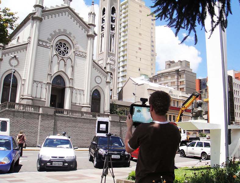
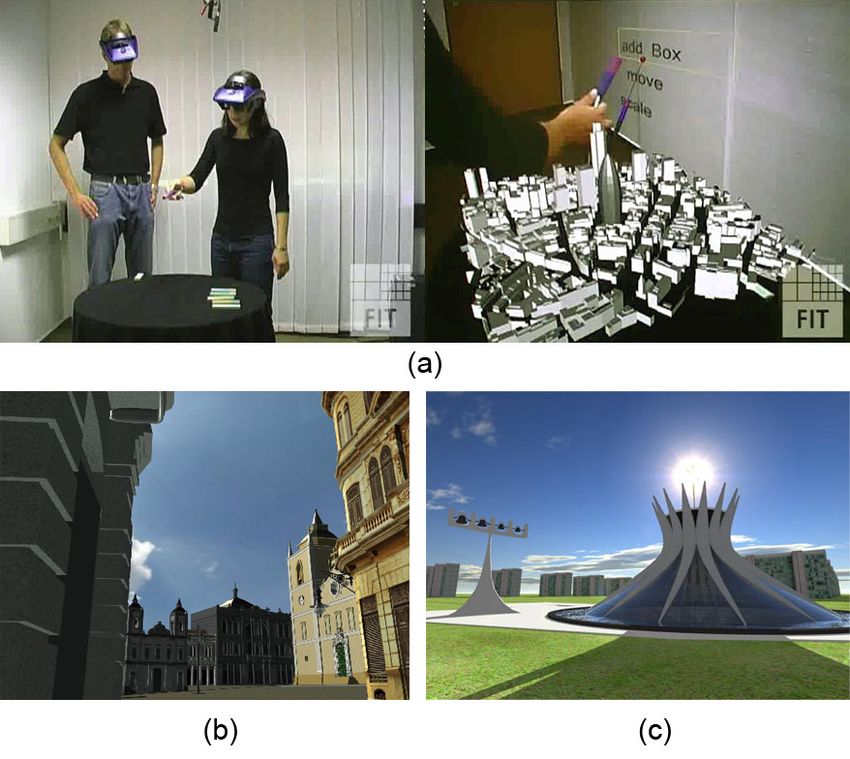
and represents an environment in which the objects from           project is that every user must wear a head mounted display
the real and the virtual worlds are presented together in the     (HMD). This can drastically limit the widespread use of the
same context [4]. Yet, in the continuum, mixed reality is         final application.
subdivided into: augmented reality and augmented virtuality.         The University of Sao Paulo (USP), developed an im-
   Augmented reality requires capturing the real world to         mersive VR environment in which the user can take a walk
the computer system (computer vision). This is usually            through a virtual model of the Sé square in the year of 1911
made in AR using a video camera or a webcam. The                  (see Figure 1b). The enormous urban changes perpetrated
basic requirements in the construction of an AR system are        since the 1880’s motivated the choice of that specific site. A
tracking, registration and display [5].                           number of references, including iconographic, cartographic
   In tracking, the first step is capturing a video frame. The    and documental sources have been used for 3D reconstruc-
frame is then analyzed and patterns are recognized, which         tion with Maya (Autodesk). The reconstructed model has
can be markers (tags) or pre-established information (like        been then visualized in a CAVE environment for a virtual
contours and edges). When markers are used, the approach          walkthrough in the ancient urban space [10].
is called marker-based. Artificial patterns are placed along         In another approach, the project Brası́lia 3D [11], depicts
the real environment (fiducial markers) for camera pose           the capital city in an electronic maquette showing details of
estimation. On the other hand, markerless approaches use          its monuments and the architecture with textual description
patterns of the real scene captured by the camera (colors,        (see Figure 1c). Users can go for a virtual ride by car
lines, etc.).                                                     or helicopter choosing the spots to be visited. The goal
   When any of these patterns are found, the system registers     is to encourage education, regional development and civic
their positions and calculates the transformation of the          and cultural tourism using three-dimensional immersion and
pattern on the frame of the camera.                               interactivity.
   Then, the three-dimensional virtual object is associated
to the pattern – according to the estimated pose (position
and orientation) registered for the pattern – and can be
displayed at that emplacement. Tracking, registration and
display procedures are repeated continuously during the
video capture.
B. Virtual historical heritage
   Visualization and interaction technology for immersive
environments are in constant development. Complex and
realistic virtual worlds can now be handled thanks to signi-
ficative advances in computer graphics and simulation.
   Research is being conducted all around the world which is
producing reconstituted models, scenario animations, ancient
environments, historical objects and buildings [6] [7]. All
this media content generate a technological cosmos which
favors new developments in VR and AR.
   The ARCHEOGUIDE project [8] is one of the pioneers to
combine AR and historical heritage. The project used GPS
and compass to define the pose of a user in the Olympia
site in Greece, and render historical and touristic information   Figure 1: Previous work on virtual urban spaces: a) Aug-
to users. The project, nevertheless, relies on heavy hi-tech      mented Round Table for Architecture and Urban Planning
equipment which despite its high cost is not accurate and         [9]; b) VR model of the S square in the year of 1911 [10];
depends on a considerably complex infrastructure.                 c) Brası́lia 3D [11].
   The project ARTHUR (Augmented Round Table for
Architecture and Urban Planning) of Fraunhofer Institut
consists in a collaborative round table in AR which replaces         These projects are examples of AR and VR applications
drawings, plans and maquettes for building planing [9].           in the urban space. With the fast development in computer
Without physical models, architects and clients modify their      graphics and the availability of new mobile devices creates
computer generated virtual models collaboratively around a        a fertile ground for the development of new applications in
common table (see Figure 1a). Gestures with fingers or a          the area of virtual historical heritage.
stylus can be used for object manipulation implementing a            In the next section, we describe our approach to popular-
magic-wand approach. One inconvenient requirement of the          ize the access to historical heritage using AR.
III. D ESIGN AND IMPLEMENTATION OF THE HISTORICAL                documental and iconographic research to build a chronologi-
        HERITAGE AUGMENTED REALITY SYSTEM                        cal evolution hypothesis of every element around the square.
   In the system implementation we used C++ with the game        From the hypotheses, they defined phases, comprehending
engine irrLicht. The libraries ARToolkit and irrAR are also      the period starting with the first edification in a specific spot,
integrated, as described in the subsections below. As for the    passing through changes in elements of the composition,
3D models, they have been prepared with 3D Studio Max            until demolition and new edification. After that, modeling
and imported as a irrLicht scene.                                of each phase follows the procedures defined in Figure 2:
                                                                 (a) volumetric simplification, (b) formal interpretation, (c)
A. Third party software                                          measuring, (d) general 3D model, (e) detailed 3D model
                                                                 and (f) filling the gaps. Modeling software as Blender, 3D
   1) ARToolkit: In this work we used the ARToolkit library
                                                                 Studio Max e Sketchup have been used [1].
and fiducial markers (tags) as auxiliary elements to capture
positions and prove our concept. The use of tags has
demonstrated great practical results and is fast enough for
real time applications. Tags are images with easy to extract
visual features. They are printed in paper and do not need
any electronic device associated. The most used resource
based on tags for AR is the ARToolkit. A simple design for
an AR application with the toolkit, which is nicely described
in their website, consists of the following:
   • start video configuration, reading markers database and
      camera parameters;
   • capture a video frame;
   • detect and identify markers on the video;
   • calculate the marker transformation in relation to the
      camera;
   • draw virtual objects using the pose defined by this
      transformation.
   With ARToolkit, the visualization of a virtual object
occurs when the associated marker appears on the video
camera field of view.
   2) irrLicht: irrLicht is an open source game engine
implemented in C++. Game engines are computer programs
and sets of libraries generally used to simplify the develop-
ment of games and other real time graphics applications.
Basic functionalities of irrLicht as a game engine are a
graphics package for rendering, a physics package for col-                      Figure 2: Modeling procedures.
lision detection and physics simulation, support to sound
generation, support to artificial intelligent behavior and so       The models corresponding to four construction phases
on.                                                              were loaded into the engine environment. We named them:
   irrLicht supports a large variety of formats as 3ds, MD2,     year 1899, year 1920, year 1932 and year 1947. Anticipating
Maya, obj, Quake 3. Light sources, virtual camera and 3D         that the system would have to display only one of the
models are organized in a hierarchy of scene nodes, which        phases at each time, we worked on a transition strategy
can be controlled by predetermined animation routines or         based on transparency with the alpha channel. In such a way,
manually by the user/programmer.                                 we would be able to provide a smooth transition between
   3) irrAR: irrAR is a library for AR development which         phases by interpolating the alpha channels of the previous
integrates the irrLicht engine with the ARToolkit. irrAr         and next phase to be displayed from 255 to 0 and 0 to 255
increases the potential of AR applications allying the ease of   respectively, simulating a fade in/out.
scene managing provided by the engine with the possibility
to independently assign scene nodes to markers.                  C. Tracking and pose determination
                                                                    An ARToolkit marker (tag) and a webcam (PS3Eye) were
B. The graphic environment                                       used for motion tracking. Tracking consists in detecting
   The methodology for creating the graphic environment          the presence of the marker and calculating its pose in
started with our colleagues architects. The first step was a     relation to the webcam. The video processing by computer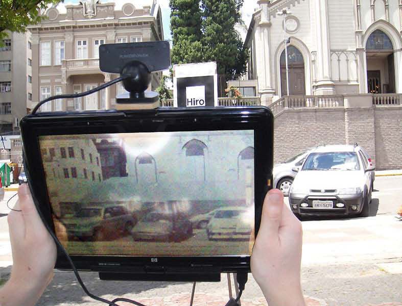
vision establishes the relation between marker and camera G. Interaction with the mobile display
coordinates. Such relation is later used to compose the Along with 3D navigation and display, the tablet PC is
transformation between the virtual camera and the models also used to navigate in a fourth dimension: time. Using the
for AR rendering. touch screen the user can slide their finger on a timeline
We placed the marker at a fixed position in the real slider bar placed vertically on the left of the display area.
environment in such a way that it does not occlude important In practice, the system starts showing the scenario as it was
parts of the video like important detail of the real buildings. in the year 1899. To explore the local architecture in other
D. Calibration years, the user rolls the slider with a finger. The system
then switches smoothly to the scenario of the year 1920,
The first time a marker is placed and every time it is for example, using a fade-in/out effect (Figure 3). As a year
relocated in the real world, the relation between the marker is chosen, additional descriptive and historical information
and the virtual world must be accordingly re-established. We can also be displayed on the text area at the bottom of the
implemented this through a manual calibration mode. In this screen.
mode, the user can use scroll bars on the touch screen to
change scale and translation parameters by simply sliding
with the fingers. Calibration parameters are saved and do
not need to be recalculated provided that the marker is not
moved.
E. Navigation
Since calibration is done, the user can navigate the 3D
space by moving the display (tablet PC) around the real
environment. The only requirement is that the marker is kept
in the range of the camera adapted to the tablet. Then, the
position and orientation of the display, stored in a 4x4 matrix
by ARToolkit, is constantly updated by the system using the
fixed marker as a reference. While the position is updated,
new frames are rendered in real time and exhibited together
with the background video, as described in section III-F
below.
F. Rendering and shading
After a phase (year) is selected and the camera parameters
are calculated from the marker, the scene can be rendered. Figure 3: Interaction through the navigation bar placed in
The next step then is to configure the shading parameters. the left side of the touch screen. The user changes the year
Shading is important because the virtual scene must match with a slide of a finger.
the more exactly possible the visual aspect of the real scene
for a successful fusion in AR. In the current implementation,
we take into account the date and time of the day to simulate IV. R ESULTS
the sunlight reflecting on the virtual buildings. In this section we describe tests performed with the
The position of a light source in the environment is system and show some of the results obtained so far. As
defined through a system of spherical coordinates which already stated, our case study has been the urban space
allows us to estimate the position of the sun in relation to around the central square Dante Alighieri in the city of
the scene. In such system, the cartesian coordinates (x, y, z) Caxias do Sul.
of any point can be computed from the spherical coordinates
(r, Φ, Θ) using equation 1. r is the radius of the sphere and A. Qualitative evaluation
can be seen as the distance between the scene and the sun. For all tests during development and for demonstrations
Φ is the elevation angle and can be seen as the latitude angle in the lab we used a maquette of the most important building
for the sun. Θ is the azimuth angle, which in turn, can be in our scenario: the 110 years old Saint Theresa Cathedral.
seen as the longitude of the sun. The maquette has been constructed in a 40 : 1 scale and a
tag was placed on the front wall for calibration and tests.
x = r sin Φ cos Θ In calibration mode we used the sliders through the touch
y = r sin Φ sin Θ (1) screen to control scale and translation parameters in such a
z = r cos Φ
way that a direct spatial correspondence has been established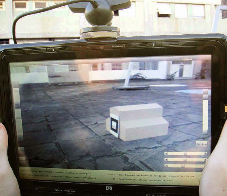
between the maquette and the 3D model. The parameters are preservation of the historical heritage, not only in Caxias
then saved and we could start navigation. do Sul, our case study. The results prove the concept, and
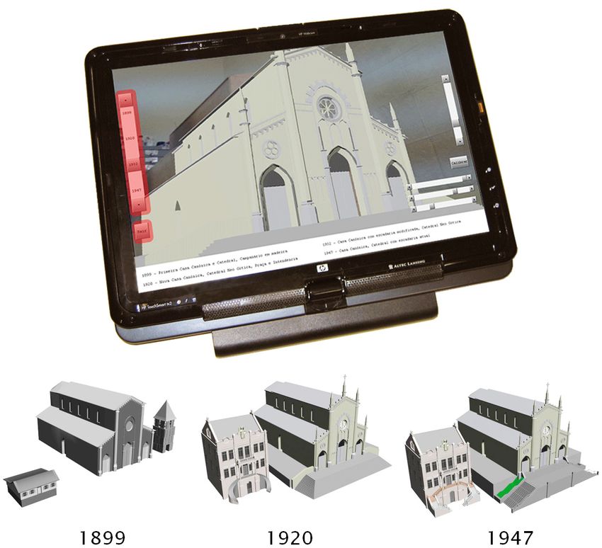
Figure 4 depict the visual results. The interaction was if the system is further extended around the common goal
smooth, without flickering and very intuitive for users with of maintaining the architectural heritage present, it might
experience in 3D modeling tools and games. The tag has become an important integration factor between the areas of
always been detected, even at sharp angles, being lost only historiography, architecture, VR and AR.
when the lighting conditions were very poor. As immediate future work, we propose the use of mark-
A second test has been performed in the actual site of erless computer vision tracking for AR. This would give
the Cathedral. A tripod was used to place the tag at a greater freedom to users as it does not require to spread a
convenient fixed position between the user and the building. number of tags in the environment, which would end by
New calibration was required due to the different scale generating visual pollution.
and position of the tag in relation to the scene. Here we Other future work would be in experimenting new devices.
noticed that, as manual calibration can take some time, the Augmented reality glasses (see-through) combined with
2 kg weight of the tablet PC becomes tiresome. While this some sort of hand held interaction device as the Wiimote
situation is noticed during calibration, the weight does not could increase the feeling of presence and be much less
bother the user in general navigation. Although automatic cumbersome systems than tablet PCs. This is also true when
calibration could solve this problem by using two tags cell-phones can be used, and they are already in our pockets
or detailed measurement of the relative tags positions, we to be used anywhere in the world. In this case, while GPS
believe that as calibration is a one time procedure, the and video tracking could precisely determine the user pose,
current manual approach is generally convenient. the local 3D (or 4D) data must be available for download
The tests around the real cathedral are illustrated in at any time, just as maps are available today with Google
Figure 5. The user could easily navigate and interact to see Maps. This would be a great tool and an innovative attraction
how construction details changed along time. It was also for tourism and related areas.
possible to analyze neighboring buildings, as the Canonical
ACKNOWLEDGMENTS
House, situated in the right side of the Cathedral.
Thanks are due to the professor Jaqueline Viel Caber-
B. Quantitative evaluation
lon Pedone for the reconstructed 3D models. Thanks are
This quantitative evaluation aims at verifying the mobile also due to CNPq-Brazil for the support through processes
hardware capability to process all tasks required in real time. 481268/2008-1, 481762/2008-6 and 302679/2009-0, and to
All tests used the full 4D model. This means that all four Rio Grande do Sul State research foundation for the grant
3D scenes, one corresponding to each year and version of BIC/FAPERGS.
the buildings, are loaded and rendered. While the selected
scene is presented with the alpha channel set to 255, the R EFERENCES
remaining three scenes are also rendered with alpha channel [1] A. Cattani, A. Antoniazzi, J. V. C. Pedone, M. Stumpp, and
set to 0. This makes a total of 235,040 triangles, a value R. Osmainschi, “Criação de modelos virtuais para registro do
clearly above the necessary regarding the scene complexity, patrimônio histórico: estudo de caso com softwares livres.”
in SIGraDi 2008 - Proceedings of the 12th Iberoamerican
which was used in purpose to press the hardware to the Congress of Digital Graphics, 2008.
maximum.
To impose strict constraints in computation power from [2] A. Maciel, L. P. Nedel, V. A. M. Jorge, J. M. T. Ibiapina, and
the beginning, a modest PC was used during development. L. F. M. S. Silva, “Reality cues-based interaction using whole-
It is an Intel Pentium D 2.80 GHz, 1GB RAM and nVidia body awareness,” in SAC ’10: Proceedings of the 2010 ACM
Symposium on Applied Computing. New York, NY, USA:
GeForce 7100 GS GPU. ACM, 2010, pp. 1224–1228.
With this development configuration we obtained a rate
of 5 frames per second in the final display set to a resolution [3] I. E. Sutherland, Seminal graphics: poineering efforts that
of 1280x1024 pixels. This is a poor frame rate, but it made shaped the field. New York, NY, USA: ACM, 1998, ch. A
head-mounted three dimensional display, pp. 295–302.
us confident that we would reach real time with the final
target device, a tablet PC with CPU AMD Turion X2 Ultra [4] P. Milgram, H. Takemura, A. Utsumi, and F. Kishino, “Aug-
Dual-Core Mobile ZM-82 2.20GHz, 4GB RAM and ATI mented reality: A class of displays on the reality-virtuality
Radeon HD 3200 GPU. Indeed, the application run at 15 to continuum,” in Proceedings of the SPIE Conference on Tele-
20 frames per second, which provides smooth interaction. manipulator and Telepresence Technologies, ser. Proceedings
of SPIE, vol. 2351, Boston, Massachusetts, USA, November
V. C ONCLUSION AND D ISCUSSION 1995, pp. 282–292.
This work is highly multidisciplinary. From the results [5] D. A. Bowman, E. Kruijff, J. Joseph J. LaViola, and
obtained so far, we visualize a great potential for applica- I. Poupyrev, 3D User Interfaces Theory and Pratice. Boston,
tions of VR and AR in the knowledge dissemination and MA: Ed Addison-wesley, 2005.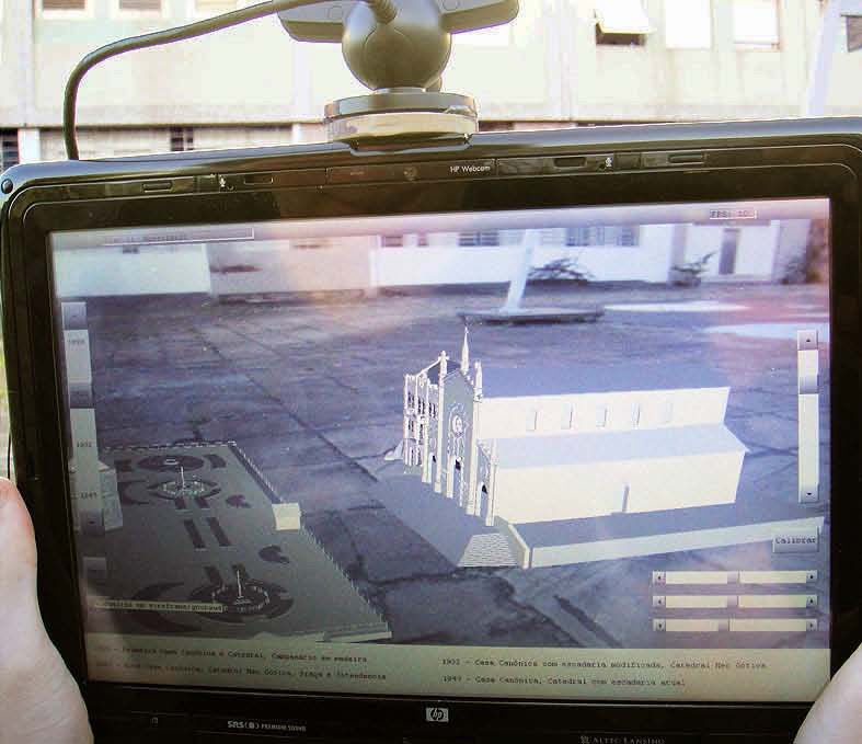
(a)                                                         (b)

                            Figure 4: System being tested with a maquette of the cathedral building.

                                      (a)                                                         (b)

Figure 5: System being tested in the actual site of the Dante Alighieri Square. Photographs show the Saint Theresa Cathedral
and a “Hiro” tag fixed with a tripod.

 [6] A. Foni and N. Magnenat-Thalmann, “A virtual heritage case             reality, archeology, and cultural heritage.   ACM, 2001, pp.
     study: an approach to the revival of ancient sites through             131–140.
     application of 3d real-time computer graphics,” in Proc. Work-
     shop on Augmented Virtual Reality (AVIR’03). MIRALab,              [9] W. Broll, “The augmented round table - a new interface
     University of Geneva, September 2003.                                  to urban planning and architectural design,” in INTERACT,
                                                                            2003.
 [7] N. Magnenat-Thalmann and G. Papagiannakis, “Virtual
     worlds and augmented reality in cultural heritage applica-        [10] M. K. Zuffo and R. de Deus Lopes, “Ambientes de realidade
     tions,” in Proc. Recording, Modeling and Visualization of              virtual e realidade aumentada na preservação do patrimônio
     Cultural Heritage, Baltsavias et al. (eds). Taylor and Francis         histórico,” in Computação gráfica: pesquisas e projetos rumo
     Group, January 2006, pp. 419–430.                                      à Educação Patrimonial (workshop). Sao Paulo: DPH, 2008.

 [8] V. Vlahakis, J. Karigiannis, M. Tsotros, M. Gounaris,             [11] A.     Rangel,  “Braslia     3d,”    2005,   [Online; ac-
     L. Almeida, D. Stricker, T. Gleue, I. T. Christou, R. Carlucci,        cessed September 15th, 2009]. [Online]. Available:
     and N. Ioannidis, “Archeoguide: first results of an augmented          http://www.3dzine.org/Brasilia/Brasilia.html
     reality, mobile computing system in cultural heritage sites,”
     in VAST’01: Proceedings of the 2001 conference on Virtual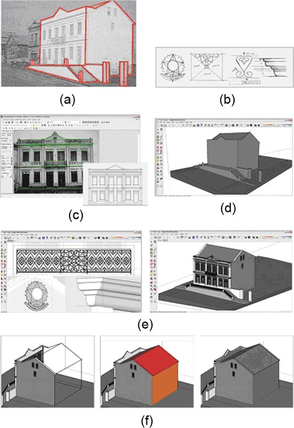
You can also read