PH TMDL for Buttahatchee River Watershed - Mississippi ...
←
→
Page content transcription
If your browser does not render page correctly, please read the page content below
pH TMDL for Buttahatchee River Watershed
Tombigbee Basin
Monroe County,
Mississippi

Prepared By

Mississippi Department of
Environmental Quality
Office of Pollution Control
Modeling and TMDL Branch

MDEQ
PO Box 2291
Jackson, MS 39225-2291
(601) 961-5171
www.deq.state.ms.us

Mississippi Department of
 Environmental Quality
Buttahatchee River pH TMDL

                                     TMDL Fact Sheet
                    pH TMDL for Buttahatchee River Watershed
The Buttahatchee River (806711) near Greenwood Springs was identified as impaired due to pH
by the Mississippi Department of Environmental Quality (MDEQ) and is listed on the 2018
Mississippi Section 303(d) List of Impaired Water Bodies (MDEQ, 2018). The specific causes of
the low pH for this water body are not known but are believed to be a combination of point source
effluent and storm water discharge over acidic soils. There are no active point sources in in the
watershed in Mississippi, but others may exist upstream in Alabama. The waste load allocation
requires that the pH in effluent from future permitted point sources shall be within the range of 6.0
to 9.0 s.u.

                              Location of Buttahatchee River Watershed

Tombigbee Basin                                                                           1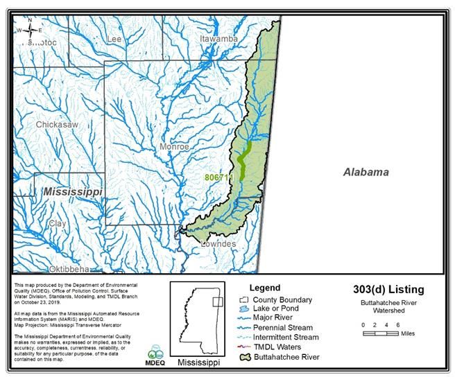
Buttahatchee River pH TMDL

                                                            CONTENTS
TMDL Fact Sheet ........................................................................................................................... 1

TMDL Information ......................................................................................................................... 4

Introduction ..................................................................................................................................... 5

Applicable Water Quality Standard ................................................................................................ 6

Watershed Characterization ............................................................................................................ 6

Source Identification ....................................................................................................................... 7

Water Quality Data ......................................................................................................................... 8

ALLOCATION ............................................................................................................................. 10

Waste load Allocation ................................................................................................................... 10

Load Allocation ............................................................................................................................ 10

Margin of Safety ........................................................................................................................... 10

Seasonality .................................................................................................................................... 10

Recommendations ......................................................................................................................... 11

Abbreviations ................................................................................................................................ 12

References ..................................................................................................................................... 13

Tombigbee Basin                                                                                                                     2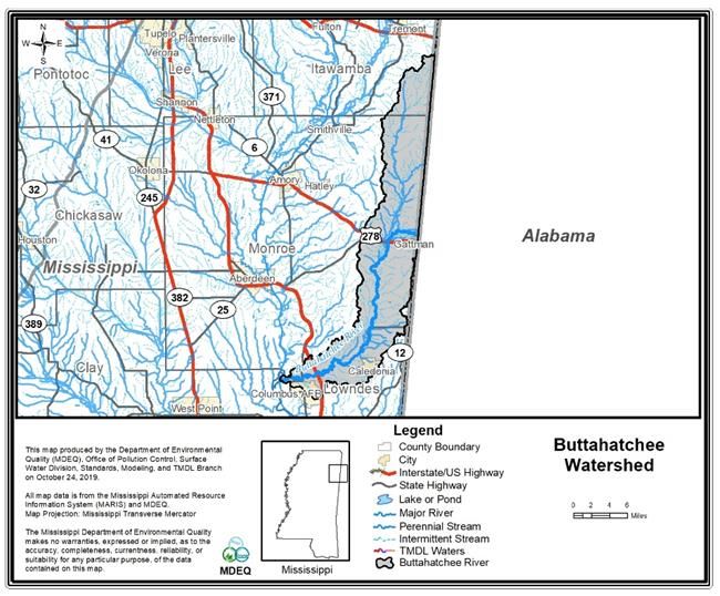
Buttahatchee River pH TMDL

                                                              Figures

Figure 1: The Buttahatchee River 303(d) Impaired Segment ......................................................... 5

Figure 2: Land use Distribution Map .............................................................................................. 7

Figure 3: Monitoring Station for Ambient Site 02439400.............................................................. 8

Figure 4: Buttahatchee River Ambient pH Data and Discharge Data ............................................ 9

                                                               Tables

Table 1: Listing Information ........................................................................................................... 4

Table 2: Water Quality Standard .................................................................................................... 4

Table 3: Landuse in the Buttahatchee River Watershed ................................................................. 6

APPENDIX A ............................................................................................................................... 14

Tombigbee Basin                                                                                                               3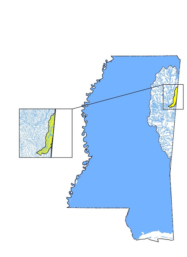
Buttahatchee River pH TMDL

                                          TMDL Information

                                          Table 1: Listing Information
               Name                            ID                  County                     Cause
         Buttahatchee River                  806711                Monroe                       pH
Near Greenwood Springs from confluence with Sipsey Creek to the 8068 MWS boundary near the confluence with Alsup
Creek

                                        Table 2: Water Quality Standard
   Parameter         Beneficial use                                 Water Quality Criteria
                                         The applicable water quality criteria, as described in the WPC-2 State of
                                         Mississippi's Water Quality Criteria for Intrastate, Interstate, and Coastal
       pH           Fish and Wildlife
                                         Waters, requires that the pH shall be within the range of 6.0 to 9.0 standard
                                         units (s.u.)

 Tombigbee Basin                                                                                          4
Buttahatchee River pH TMDL
Introduction
The Buttahatchee River (806711) was identified by MDEQ as not supporting the designated use
for the pH standard on Mississippi's 2012 Section 303(d) List of Impaired Water Bodies (MDEQ,
2018). TMDLs are required for impaired waters on the §303(d) list as required by the Federal
Clean Water Act §303(d) and the implementing regulations in accordance with 40 CFR.130. A
TMDL establishes the maximum amount of a pollutant a water body can assimilate without
exceeding the applicable water quality standard. The TMDL also allocates the total allowable load
to individual sources or categories of sources through wasteload allocations (WLAs) for point
sources, and through load allocations (LAs) for non-point sources. The WLAs and LAs in the
TMDL provide a basis for states to reduce pollution from both point and non-point source activities
that will lead to the attainment of water quality standards and protection of the beneficial use. The
impaired segment of the Buttahatchee River is shown in Figure 1.
Figure 1: The Buttahatchee River 303(d) Impaired Segment
Tombigbee Basin 5Buttahatchee River pH TMDL
Problem Definition
pH is a measure of the hydrogen ion concentration in water as well as a measure of the acidity or
alkalinity. Specifically, pH is defined as the negative logarithm of the hydrogen ion concentration
in terms of moles per liter.
pH = -log [H+]
pH values can range from 0 s.u. for a very acidic solution to 14 s.u. for a very basic solution. A
pH equal to 7.0 s.u. represents neutrality. One of the most significant environmental impacts of
pH is the effect that it has on the solubility and thus the bioavailability of potentially toxic
substances that may be present in surface waters. As the pH in a water body becomes lower (i.e.,
the solution becomes more acidic) many insoluble toxic substances like cyanides, sulfides, and
most metals become more soluble and thus more likely to have toxic effects on fish and other
aquatic life. Slight increases in pH may greatly increase the toxicity of pollutants such as ammonia.
(Lee, 1998)
Due to high humidity in the southeast, large amounts of rainwater, which is naturally slightly
acidic, move through the soil. If weak acids are formed from the reaction of hydrogen ions
combining with carbon dioxide or other compounds, bases may be gradually leached from the soil
as the water percolates through it, lowering the soil pH. Decomposition of coniferous vegetation,
which produces more fulvic acids than either deciduous vegetation or grasses, is another process
that lowers soil pH.
Applicable Water Quality Standard
The TMDL for the Buttahatchee River will be established at a level to ensure consistency with the
applicable water quality criteria and protection of its designated use (i.e., Fish and Wildlife). The
State of Mississippi Water Quality Criteria for Intrastate, Interstate, and Coastal Waters includes
numeric water quality criteria for pH of 6.0 to 9.0 s.u. for waters with these designated uses
(MDEQ, 2016). Although there is information that suggests that waters in the basin exhibit low
pH due to natural conditions, there is currently not enough information readily available to
determine whether the low pH in this segment can be attributed to natural conditions. Therefore,
the applicable pH criteria for this segment is the allowable range of 6.0 to 9.0 s.u.
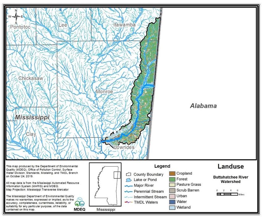
Watershed Characterization
The impaired segment of the Buttahatchee River is in Monroe County. The landuse in the
watershed is predominantly forest (Figure 2 and Table 3). The landuse information for the
watershed is based on the National Landcover Database 2006 (NLCD 2006).
Table 3: Landuse in the Buttahatchee River Watershed
Water Urban Forest Scrub/Barren Pasture Cropland Wetland
area 115.50 2369.68 41595.42 7502.11 7539.85 1229.52 16700.41
% area 0.15% 3.08% 53.98% 9.74% 9.78% 1.60% 21.67%
Tombigbee Basin 6Buttahatchee River pH TMDL
Figure 2: Land use Distribution Map
Source Identification
There are no active point sources in the watershed that discharge into the impaired segment
(806711). There may be some NPDES facilities present in the watershed in Alabama; however,
MDEQ does not have regulatory authority outside of the state.
Tombigbee Basin 7Buttahatchee River pH TMDL
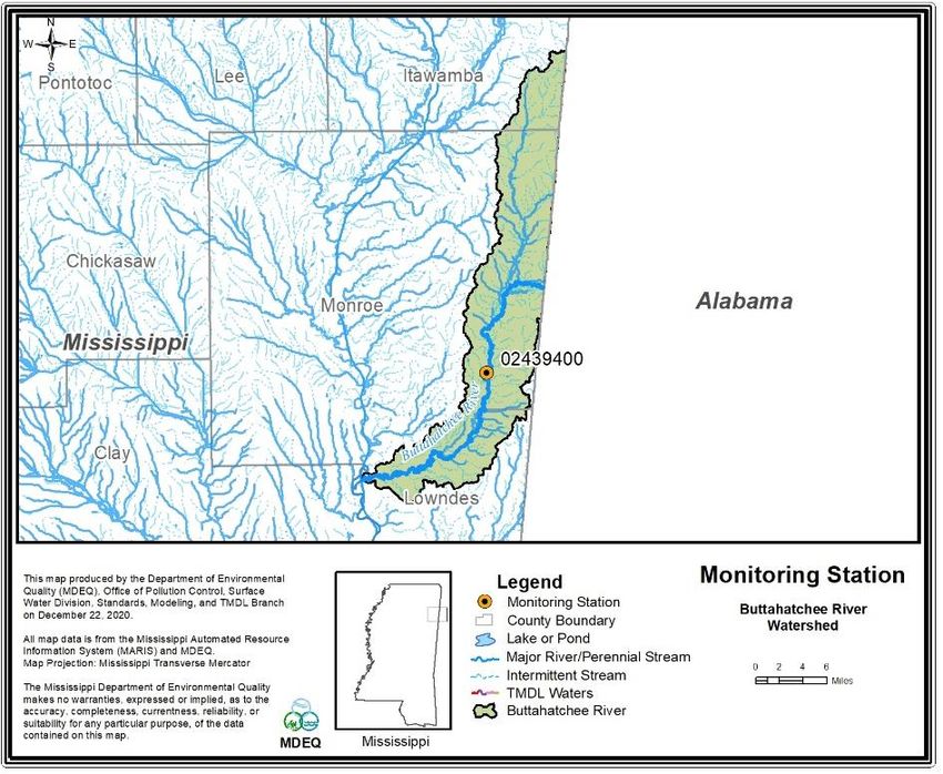
Water Quality Data
MDEQ collected ambient monthly water quality samples for the Buttatchee River from 2001 to
2014 at USGS station 02439400. The monitoring station location is shown in Figure 3. The
ambient pH data is shown in Figures 4 and shows the stage measured in the stream. The low pH
values don’t appear to be associated with any particular season or stage of flow. There is not
sufficient information available to determine the cause for the lower pH values, however, it is
believed that the low values may be attributed to the multitude of pine and oak trees located in the
forested areas of the watershed or naturally acidic soils. The lower pH values during this time
suggest naturally occurring conditions for low pH in figures 4. Ambient pH data is available in
Appendix A.
Figure 3: Monitoring Station 02439400
Tombigbee Basin 8Buttahatchee River pH TMDL
Buttahatchee River Discharge versus Ambient Data 02439400
30000 10
9
Min pH
25000
MAX pH 8
Discharge
7
Ambient
20000
6
Discharge, cfs
pH, S.U.
15000 5
4
10000
3
2
5000
1
0 0
1/1/2001 9/28/2003 6/24/2006 3/20/2009 12/15/2011 9/10/2014
Figure 4: Buttahatchee River Ambient pH Data and Discharge Data
Tombigbee Basin 9Buttahatchee River pH TMDL
ALLOCATION
A TMDL establishes the total pollutant load a water body can receive and still achieve water
quality standards. The components of a TMDL include a WLA for point sources, a LA for non-
point sources, and a margin of safety (MOS) to account for uncertainty. 40 CFR.130.2(i) provides
flexibility concerning how TMDLs are expressed and suggests that they may be expressed in terms
of mass per time, toxicity, or other appropriate measure. For this TMDL as well as other pH
TMDLs that have been established by MDEQ, it has been determined that the appropriate measure
for the allocation should be in terms of pH standard units.
Waste load Allocation
There are no point sources identified in this watershed that discharge to the listed segment. For
future dischargers to discharge to this watershed or to tributaries in the watershed, effluent pH
levels should be no less than 6.0 s.u. and no greater than 9.0 s.u. and shall not cause the pH to
rapidly change more than 1 unit s.u. This is a standard NPDES permit requirement.
Load Allocation
The nonpoint sources causing or contributing to pH violations are unknown, but probable causes
may be attributed to low pH from stormwater runoff, noncompliant point sources, groundwater
infiltration, and acid rain deposition. The load allocation for this TMDL suggests that the pH of
waters originating from any nonpoint sources in the watershed shall be no less than 6.0 s.u. and no
greater than 9.0 s.u. if possible based on the natural conditions found in the watershed.
Margin of Safety
The margin of safety in TMDLs is used to account for the lack of knowledge concerning the
relationship between the pollutant loads and the resulting quality of the receiving water body. The
allocations used in this TMDL ensure that loads from any point source(s) and loads originating
from any non-point source activities must individually meet the pH target of 6.0 to 9.0 s.u. before
entering the stream. As long as pH from both point and non-point source activities are consistent
with the allocations in this TMDL, water quality standards will be met.
Seasonality
The allocation proposed for this TMDL provides for year-round protection (i.e., protection during
all seasons and environmental conditions) of the pH criteria. Based on the available data and
information, critical conditions for this TMDL could not be determined. However, considering
that this TMDL is protective during all seasons and environmental conditions, it will inherently be
protective during critical conditions whenever they occur.
Tombigbee Basin 10Buttahatchee River pH TMDL
Recommendations
The waste load allocation for this TMDL is considered and used by MDEQ through its NPDES
permitting process. This TMDL recommends further ambient monitoring within the stream.
Subsequent NPDES permit applicants should further study the data to determine the natural
condition of this segment and evaluate the possibility of a site-specific criterion for pH for this
segment of the Buttahatchee River.
Achieving the load allocation will require a better understanding of the causes and sources of the
low pH. Future monitoring and data collection should provide insight regarding the potential
causes of the low pH in this watershed. If low pH is determined in the future to be attributed to
natural conditions, the load allocation presented in this TMDL could not be reasonably expected
to be achieved. If such a determination were to be made, revision of the TMDL and/or the
development of a site-specific water quality standard for these segments may be appropriate.
Public Participation
This TMDL will be published for a 30-day public notice. During this time, the public will be
notified by publication in the newspaper. The public will be given an opportunity to review the
TMDL and submit comments. MDEQ also distributes all TMDLs at the beginning of the public
notice to those members of the public who have requested to be included on a TMDL mailing
list. Anyone wishing to become a member of the TMDL mailing list should contact Shawn
Clark at sclark@mdeq.ms.gov.
All comments should be directed to Shawn Clark at sclark@mdeq.ms.gov or MDEQ, PO Box
2261, Jackson, MS 39225. All comments received during the public notice period will become a
part of the record of this TMDL and will be considered in the submission of this TMDL to EPA
Region 4 for final approval.
Tombigbee Basin 11Buttahatchee River pH TMDL
ABBREVIATIONS
EPA ............................................................................................. Environmental Protection Agency
LA ........................................................................................................................... Load Allocation
MDEQ ............................................................... Mississippi Department of Environmental Quality
MOS ....................................................................................................................... Margin of Safety
NPDES ............................................................... National Pollution Discharge Elimination System
TMDL .................................................................................................. Total Maximum Daily Load
TSS............................................................................................................... Total Suspended Solids
USGS ............................................................................................ United States Geological Survey
WLA ............................................................................................................... Wasteload Allocation
NLCD.................................................................................. National Landuse/ Land Cover Dataset
Tombigbee Basin 12Buttahatchee River pH TMDL
REFERENCES
Canter, L. W. (1985). River Water Quality Monitoring. Chelsea, Michigan: Lewis
Publishers, Inc.
Chapra, S. C. (1997). Surface Water Quality Modeling. New York: McFraw-Hill.
EPA. (1991). Guidance for Water Quality-based Decisions: The TMDL Process.
Washington, D.C.: EPA Office of Water.
Lee, C. P. (Ed.). (1998). Environmental Engineering Dictionary. Rockville, Maryland:
Government Institutes, Inc.
MDEQ. (2013). WPC-1 NDPES Permitting Regulations. Jackson: MDEQ Office of
Pollution Control.
MDEQ. (2016). WPC-2 Mississippi Water Quality Criteria for Intrastate, Interstate, and
Coastal Waters. (K. D. Caviness, Ed.) Jackson: MDEQ Office of Pollution Control.
MDEQ. (2018). Mississippi 2018 Section 303(d) List of Impaired Water Bodies. (G. A.
Jackson, Ed.) Jackson, Mississippi: MDEQ Office of Pollution Control.
Water Quality Standards for Surface Waters. (2012). Retrieved from EPA Water: Water
Quality Standards: http://water.epa.gov/scitech/swguidance/standards/
Tombigbee Basin 13Buttahatchee River pH TMDL
APPENDIX A
( Ambient pH Data for Station 02439400 04/10/2001-11/05/2013)
STATION_ID ACTIVITY_DATE pH
2439400 04/10/2001 14:50 6.14
2439400 06/20/2001 13:45 7.39
2439400 07/18/2001 13:30 8.04
2439400 09/18/2001 13:45 7.57
2439400 10/22/2001 13:25 8.11
2439400 08/09/2007 11:00 7.15
2439400 09/06/2007 11:38 6.78
2439400 10/04/2007 11:10 7.49
2439400 11/15/2007 11:56 7.55
2439400 12/04/2007 10:45 7.31
2439400 01/07/2008 11:56 6.33
2439400 02/13/2008 11:14 5.29
2439400 03/10/2008 12:40 6.33
2439400 04/09/2008 10:48 6.46
2439400 05/07/2008 11:45 6.78
2439400 06/11/2008 11:43 5.79
2439400 07/10/2008 11:40 5.97
2439400 08/06/2008 10:02 5.02
2439400 09/09/2008 10:58 5.6
2439400 10/07/2008 11:10 5.79
2439400 11/12/2008 09:25 4.49
2439400 12/13/2008 10:45 6.41
2439400 01/08/2009 11:58 6.13
2439400 02/10/2009 10:15 6.17
2439400 03/09/2009 12:51 5.54
2439400 04/08/2009 11:20 5.96
2439400 05/13/2009 11:33 5.28
2439400 06/09/2009 11:15 5.32
2439400 07/14/2009 11:58 5.98
2439400 08/11/2009 11:45 5.91
2439400 09/22/2009 11:31 5.23
2439400 10/20/2009 11:45 5.87
2439400 11/03/2009 11:30 6.37
2439400 12/03/2009 11:30 5.78
2439400 01/13/2010 11:48 5.4
2439400 02/18/2010 11:41 5.31
2439400 03/30/2010 10:55 5.25
2439400 04/08/2010 10:51 5.75
2439400 05/11/2010 11:18 5.4
Tombigbee Basin 14Buttahatchee River pH TMDL STATION _ID ACTIVITY_DATE pH 2439400 06/10/2010 11:12 5.16 2439400 07/21/2010 11:12 5.25 2439400 08/19/2010 12:01 5.14 2439400 09/21/2010 11:28 6.07 2439400 10/12/2010 11:21 6.18 2439400 11/18/2010 11:16 6.17 2439400 12/02/2010 10:39 4.86 2439400 01/24/2011 10:58 7.54 2439400 02/15/2011 11:45 7.38 2439400 03/08/2011 11:56 6.7 2439400 04/18/2011 12:20 7.16 2439400 05/10/2011 11:21 7.06 2439400 06/09/2011 12:47 8.22 2439400 07/14/2011 11:30 7.39 2439400 08/04/2011 11:08 6.01 2439400 09/02/2011 11:27 6.19 2439400 10/17/2011 11:27 6.21 2439400 12/08/2011 12:15 8.88 2439400 02/25/2013 13:10 5.69 2439400 03/14/2013 12:16 4.66 2439400 04/10/2013 11:55 5.91 2439400 05/09/2013 11:45 5.95 2439400 06/12/2013 12:50 5.27 2439400 07/02/2013 11:30 5.86 2439400 08/16/2013 11:50 5.73 2439400 09/12/2013 12:18 5.81 2439400 10/07/2013 11:30 4.95 2439400 11/05/2013 11:30 5.07 Tombigbee Basin 15
You can also read