Physico-Chemical Characteristics of Gushing Water Aquifers in the Coastal Sedimentary Basin of Benin (West Africa)
←
→
Page content transcription
If your browser does not render page correctly, please read the page content below
Journal of Geoscience and Environment Protection, 2021, 9, 149-163
                                                                                                https://www.scirp.org/journal/gep
                                                                                                          ISSN Online: 2327-4344
                                                                                                            ISSN Print: 2327-4336

Physico-Chemical Characteristics of Gushing
Water Aquifers in the Coastal Sedimentary
Basin of Benin (West Africa)

Prudence Mahutondji Dossou1,2*, Crépin Zevounou2, Abdoukarim Alassane3, Christophe Kaki2,
Moussa Boukari3, Daouda Mama3
1
 Chaire Internationale en Physique, Mathématique et Applications (CIPMA-Chaire UNESCO), Université d’Abomey-Calavi,
Abomey-Calavi, Bénin
2
 Laboratoire de Géologie, Mines et Environnement, Faculté des Sciences et Techniques, Université d’Abomey-Calavi,
Abomey-Calavi, Bénin
3
 Laboratoire d’Hydrologie Appliquée (LHA), Institut National de l’Eau (INE), Université d’Abomey-Calavi,
Abomey-Calavi, Bénin

How to cite this paper: Dossou, P. M.,         Abstract
Zevounou, C., Alassane, A., Kaki, C., Bouka-
ri, M., & Mama, D. (2021). Physico-Chemical    The coastal sedimentary basin in southern Benin consists of monoclinal lay-
Characteristics of Gushing Water Aquifers      ers divided into two plateau zones (North and South) which are separated by
in the Coastal Sedimentary Basin of Benin      a longitudinal depression ESE-WNW. The valleys of the main N-S-oriented
(West Africa). Journal of Geoscience and
                                               rivers (Ouémé, Couffo and Mono) set the bondaries of the different plateau
Environment Protection, 9, 149-163.
https://doi.org/10.4236/gep.2021.97010         of the BSC (Coastal Sedimentary Basin). The present study, based on geology,
                                               hydrochemistry, temperature and log data available on boreholes, makes a
Received: May 30, 2021                         physico-chemical characterization of the waters of the gushing aquifers of the
Accepted: July 25, 2021                        coastal sedimentary basin of Benin. The gushing water boreholes are shared
Published: July 28, 2021
                                               between the valleys of the main rivers of the BSC. Some of these boreholes are
Copyright © 2021 by author(s) and              thermal with a water temperature between 38 and 69 degrees Celsius. The hy-
Scientific Research Publishing Inc.            drogeological correlations established in the BSC in accordance to the North-
This work is licensed under the Creative       South direction in the valleys of the main streams (Couffo and Ouémé) reveal
Commons Attribution International              that the captured aquifers are sands, marls and limestones that respond either
License (CC BY 4.0).
http://creativecommons.org/licenses/by/4.0/
                                               in major discordance (northern zone) or above the sedimentation gaps (south-
                Open Access
                                               ern zone). Chemical analyses have shown that gushing thermal waters are
                                               mineralized in the south with a neutral to basic pH and are highly concen-
                                               trated with bicarbonate, calcium and magnesium ions. In the North, on the
                                               other hand, thermal waters are acidic with a pH ranging from 4.8 to 5.9. The
                                               acidic nature of the northern waters is influenced by the crystalline base while
                                               the southern neutral to basic waters are influenced by the lithological nature
                                               (limestone and marl) of the aquifer. The random distribution of thermal wa-
                                               ter boreholes in the valleys of the main BSC streams is believed to be related
                                               to tectonic events.

DOI: 10.4236/gep.2021.97010         Jul. 28, 2021                149            Journal of Geoscience and Environment Protection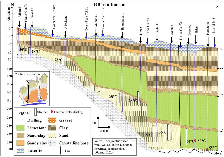
P. M. Dossou et al.

                                Keywords
                                Gushing Aquifers, Thermal Water, Physico-Chemical, BSC

                              1. Introduction
                              Groundwater is a valuable asset for human consumption and other multiple uses;
                              this is especially true when groundwater is thermal (IEA, 2011). Also, they are eas-
                              ily accessible when they are gushing (Adissin et al., 2019). Indeed, gushing water
                              points are particularly appealing because households access them without spend-
                              ing energy in pumping. Moreover, the permanent flow of these waters promotes
                              their multiple uses for the development of small-scale agriculture (market garden-
                              ing, irrigation) and livestock (Ahossi, 2020). As thermal water, they also serve oth-
                              er purposes such as energy supply and sanitary treatment (Kapasa, 2014).
                                 In Benin, in the coastal sedimentary basin, boreholes have captured gushing wa-
                              ter aquifers, sometimes thermal water in some communities (Boukari & Alassane,
                              2007). Besides the aforementioned uses, thermal waters are used for palm oil
                              processing activities. Among the multitude of gushing water boreholes, one can
                              notice an unexplained distribution of gushing and thermal water points to this day.
                                 This study aims to characterize gushing water aquifers with an emphasis on
                              the origin of the distribution of thermal abnormalities.

                              2. Presentation of the Study Area
                              2.1. Localization
                              The territorial scope of the coastal sedimentary basin of Benin encompasses the
                              localities situated in the latitudes 7˚36' and 7˚12' North and longitudes 1˚36' and
                              2˚48' East (Figure 1). The total area is about 11,200 km2 (Boukari, 2002). From
                              administrative standpoint, it includes the entire Atlantic, Coastal, Mono, Ouémé,
                              Plateau and part of the Zou and Couffo provinces.

                                      Figure 1. Location of the study area in Dahomey Bay.

DOI: 10.4236/gep.2021.97010                        150             Journal of Geoscience and Environment Protection
P. M. Dossou et al.

                              2.2. Climate
                              In Benin, the annual average temperatures range from 26.5 to 27.5 degrees Cel-
                              sius depending on the region (Boukari, 2002). The relative humidity is very high
                              everywhere during the rainy season (80% on average in July and September).
                              This rate drops during the warmer season (mainly between January and Febru-
                              ary) to about 60% in the South (Le Barbé et al., 1993). The annual rainfall system
                              to which the coastal sedimentary basin belongs is equatorial (or sub-equatorial)
                              and consists of four seasons (a large warm season from November to April, a
                              large rainy season from April to July, a small warm season from July to Septem-
                              ber, and a small rainy season from September to November).

                              2.3. Geomorphology
                              The coastal sedimentary basin is located in the southern part of Benin and con-
                              sists of sediments supported by a crystallophyllian base (Boukari, 2002). The
                              morphology of the coastal sedimentary basin is characterized by two sets of pla-
                              teaux arranged on either side of an ENE-WSW-oriented median depression, the
                              Lama depression (Figure 2). The main rivers (Mono, Couffo and Ouémé) flow
                              southward and form respectively the valleys of Mono, Couffo and Ouémé (Le
                              Barbé et al., 1993).

                                       Figure 2. Geomorphological map of the coastal sedimentary basin
                                       of Benin (Slansky (1962) modified after IRB (1989), City by Boukari
                                       and Alassane (2007)): Comé plateau; 2: Aplahoué plateau; 3: Allada
                                       plateau; 4: Abomey plateau; 5: Sakété plateau; 6: Kétou plateau.

                              2.4. Geology
                              The geology of the Coastal Sedimentary Basin of Benin is the same as the Bay of
                              Dahomey (Figure 3), which extends from Ghana on the west, and to Nigeria on
                              the east (Slansky, 1962). These deposits have a monoclinal structure characte-
                              rized by differential subsidence increasing toward the SSE (Dray et al., 1989).
                              Based on lithological and sedimentological landmarks that support successive
                              variations in sea level, eight stratigraphic units have been enumerated (Figure 3)
                              from the Turonian-Coniacien (Unit I) to the Quaternary (Unit VIII), (Slansky,
                              1962; Lang & Houessou, 1978; Zevounou, 1992; Oyede et al., 2006; Zevounou et
                              al., 2012): Unit I (Turonian-Coniacien): quartz sands with pebbles, intercalations
                              of lignitous and marno-limestone levels; Unit II (Maastrichtian, Lower and
                              Middle Paleocene): sands, argillites, marls, limestone; Units III to IV (Upper Pa-

DOI: 10.4236/gep.2021.97010                       151             Journal of Geoscience and Environment Protection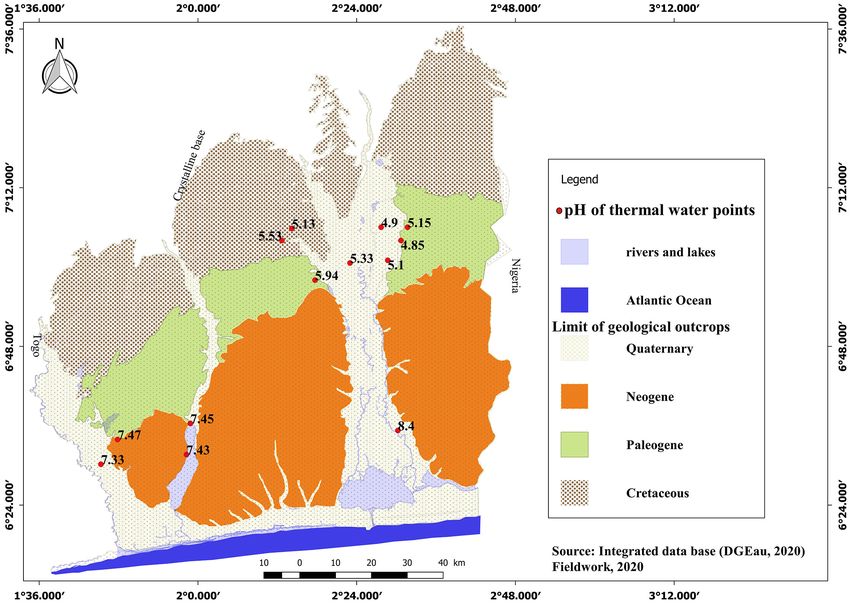
P. M. Dossou et al.

                              leocene, Middle Eocene): Kaolinitic clay, argillites, sometimes marl; Units V to
                              VII (Mio-Pliocene, “Continental Terminal”): quartz sands, gravel; Unit VIII
                              (Quaternary): sands and argillites.

                              Figure 3. Geological map of the Benin County Sedimentary Basin (extracted from geo-
                              logical sheets at 1/200,000 Lokossa-Porto Novo and Abomey-Zangnanado (IRB, 1989)).

                              2.5. Hydrogeology
                              By their lithological nature (Figure 3), the geological formations of the coastal
                              sedimentary basin of Benin are grouped into four hydrogeological reservoirs. From
                              north to south, there are listed as follow:
                              - The Upper Cretaceous sand aquifer or Unit I (Figure 3). It can reach up to
                                 150 meters of thickness but remains mostly less accessible to the south of the
                                 basin due to its rapid sinking (Boukari, 2005). While its nappe is free in the
                                 north of the depression of Lama, where it emerges, it is captivated, in the
                                 South, under the argillites and the marls of both Maastrichtian and Eocene,
                                 where it sinks rapidly.
                              - The aquifer of the Paleocene limestone or IIb unit is essentially captivated
                                 under the argillites and marls of the Upper Paleocene and the Lower and
                                 Middle Eocene (Figure 3). Its thickness varies from a few meters to a maxi-
                                 mum of thirty meters (Boukari, 2005). It is sometimes outcropping or sub-
                                 outcropping inside the Lama depression, then rapidly sinks southward and
                                 gets captivated under the clays in the valleys of the main BSC streams (Bou-
                                 kari & Alassane, 2007).
                              - The sand aquifer of the Upper Miocene-Pliocene or Units VI and VII (Figure
                                 3). Its maximum thickness is generally around 120 meters and its nappe is
                                 usually free. Moreover, it is superficially subdivided into three hydrogeologi-

DOI: 10.4236/gep.2021.97010                        152              Journal of Geoscience and Environment Protection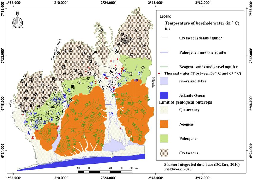
P. M. Dossou et al.

                                 cal units morphologically represented by the southern plateaus of the basin
                                 (Boukari, 2005).
                              - The Quaternary aquifers or Unit VIII are represented by the aquifers of the
                                 coastal sands, on one hand, and those of the alluvial sands on the other
                                 (Figure 3). Their maximum thicknesses are around 20 meters (Boukari &
                                 Alassane, 2007). In the alluvial valleys of the Mono River and especially the
                                 complex Oueme-Lac Nokoué, aquifers are often loaded under more or less
                                 superficial argillites with frequent phenomena of gushing artesian.

                              3. Material and Methods
                              The methodological structuring of this study is described in three phases: the
                              collection of existing data; on-site work and processing and analysis of the data
                              obtained.

                              3.1. Material
                              The collected data relate to the lithology of boreholes that capture the gushing
                              water aquifers of the Upper Cretaceous and Paleocene, especially those with ther-
                              mal water. The topographic sheets, the geological sheets (Abomey-Zangnanado,
                              Lokossa-Porto Novo) made at a scale of 1/200,000 were also collated. The tem-
                              perature of the borehole waters that capture the Cretaceous, Paleocene and Mi-
                              ocene-Pliocene aquifers has been collated. These data are obtained from the
                              structures responsible for water management (General Directorate of Water,
                              Department of Water) and the Benin Office of Geological and Mineral Research
                              (OBRGM).
                                The on-site work is performed with the aim of mapping the geothermal ab-
                              normal points in the coastal sedimentary basin; therefore, a GPS has been used.
                              The measurement of the physico-chemical parameters and the water sampling of
                              the thermal boreholes allowed the geochemistry of the thermal anomaly zones to
                              be highlighted. At each thermal water point encountered, the geographical coor-
                              dinates are recorded along with pH and temperature values, conductivity and
                              water collection.

                              3.2. Data Analysis and Processing
                              In order to better describe the geometry and structure of the gushing aquifers in
                              the study area, two hydrogeological sections were performed along the north-
                              south oriented lines AA' and BB'. Chemical analyses were performed on eight
                              samples and were focused on some major water elements ( NH +4 , Ca2+, Mg2+,
                               HCO3− ).
                                 Temperature and depth data collected from the boreholes are entered into
                              Surfer and QGIS to obtain maps of iso-depht and isotherms after validation with
                              the coefficient of some statistical parameters such as the NASH and RSR coeffi-
                              cient of the Cretaceous, Paleocene and Neogene aquifers. Table 1 shows the
                              characteristics of the fitted variograms.

DOI: 10.4236/gep.2021.97010                         153          Journal of Geoscience and Environment Protection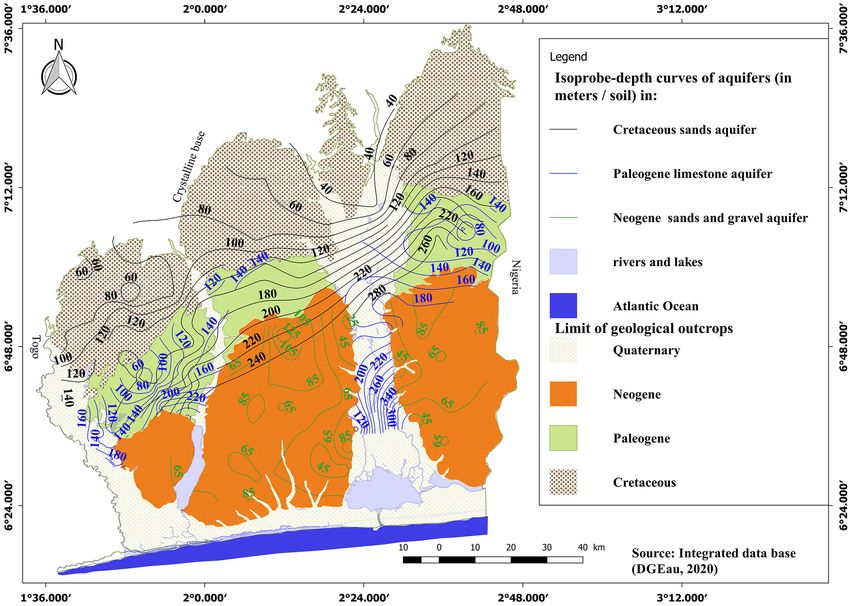
P. M. Dossou et al.
Table 1. Characteristics of variograms.
Data Aquifers Model NASH RSR
Neogene (a) 0.78 0.50
Depth Paleogene (b) 0.80 0.40
Cretaceous (c) 0.76 0.50
Power
Neogene (a') 0.84 0.39
temperature Paleogene (b') 0.81 0.42
Cretaceous (c') 0.79 0.51
Figure 4 shows respectively the variograms of customized models of the depth
and temperature of the Neogene (aa'), Paleocene (bb') and Cretaceous (cc') of
the coastal sedimentary basin. One can notice upon observation of these figures
(Figure 4) that the model passes through the majority of points. The interpola-
tion method used is Kriging and the power model was chosen for the kriging.
This model adjusted for the raw variogram allowed us to obtain depth and tem-
perature values in areas where there are no measurements (Lawin, 2007). The
expression of the variogram of the power model is:
) C0 + ( α − C0 ) hβ
γ ( h= (1)
with β ∈ ]0, 2[ ; C0 petite; h the distance
After the visual assessment of the overlay, the criteria of Nash (2) and RSR (3)
allowed us to control the adjustment made so that the theoretical variogram bet-
ter approaches the interesting part of the raw variogram (Figure 4). These crite-
ria are defined as follows:
Nash (coefficient of Nash, NSE)
(
n Y obs − Y sim
∑ i =1 1 )
2
NSE = 1 − (2)
1
n 2
∑ i =1 1 (
Y obs − Y1mean )
The adjustment is optimal when the Nash coefficient efficiency is maximum
(close to 1).
RSR (standard observations deviation ratio)
∑ i =1 (Y1obs − Y1sim )
n 2
RSR =
RMSE
= (3)
STDEVobs 2
∑ i =1 (Y −Y )
n obs mean
1 1
The model is optimal when RSR is less or equal to 0.70 (Moriasi et al., 2007).
This method allows us to identify the best set of parameters (C0, C and a) that
characterize the modeled variogram (Lawin, 2007).
DOI: 10.4236/gep.2021.97010 154 Journal of Geoscience and Environment Protection
P. M. Dossou et al.

                          Figure 4. Avariogram of distances adjusted for depth (a, b and c) and temperature (a', b' and c') of
                          the BSC Neogen, Paleocene and Cretaceous aquifers.

DOI: 10.4236/gep.2021.97010                                155             Journal of Geoscience and Environment Protection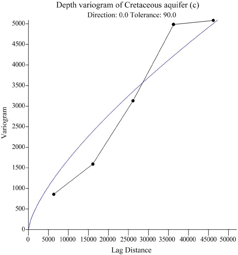
P. M. Dossou et al.

                                   4. Results
                                   4.1. Distribution of Captured Aquifers and Depth Variation
                                   4.1.1. Analysis of AA' and BB' Lithostratigraphic Sections
                                   The N-S lithostratigraphic correlations of section AA' in the Ouéme river wa-
                                   tershed reveal six facies (Figure 5). From top to bottom, these are clay or laterite,
                                   gravel, clay sand, limestone and sand. The summit formations are represented
                                   by clays or laterites in the works. In the northern part of the section, the base is
                                   represented by the Gneiss and is located at a depth of about 100 meters. The
                                   sandy layer is located at a depth of about 90 meters and gradually sinks toward
                                   the southern part of the section. The thermal water points captured the sands at
                                   an average depth of 160 meters to about 200 meters. The temperature of these
                                   waters is between 39 and 50 degrees Celsius (Sagon and Gohissanou, respective-
                                   ly). In the southern part of the section, at the localities of Ahitonou, the forma-
                                   tions captured are limestones. The Ahitonou borehole captures these limestones
                                   at a depth of about 60 meters with a temperature of 41˚C while at a few hundred
                                   meters away (Atchabita), the same limestones are captured at 200 meters with a
                                   temperature of 41˚C. The two boreholes are separated by the Zounvo river,
                                   which is a tributary stream of Ouémé river. This offset observed in the forma-
                                   tions of these boreholes and the presence of the stream suggests that the area is
                                   crossed by faults. In the Southern part of the section, the limestones are located
                                   at a depth of more than 400 meters. Also, the thickness of the clays becomes
                                   consistent in this part of the section. Indeed, in the localities of Hetin-Sota, the
                                   limestones sink abruptly to a depth of about 417 meters. The water temperature
                                   of this locality is 69˚C. This sudden variation in the depth of the limestone
                                   shows that the area is crossed by faults.

                              Figure 5. North-South hydrogeological cut following the AA' cut line.

DOI: 10.4236/gep.2021.97010                               156             Journal of Geoscience and Environment Protection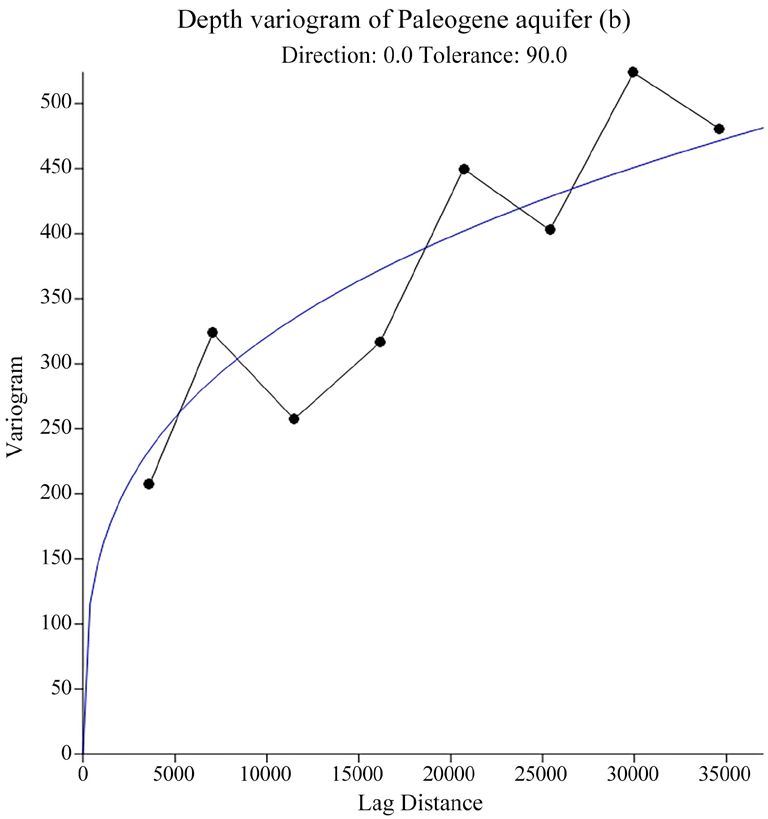
P. M. Dossou et al.
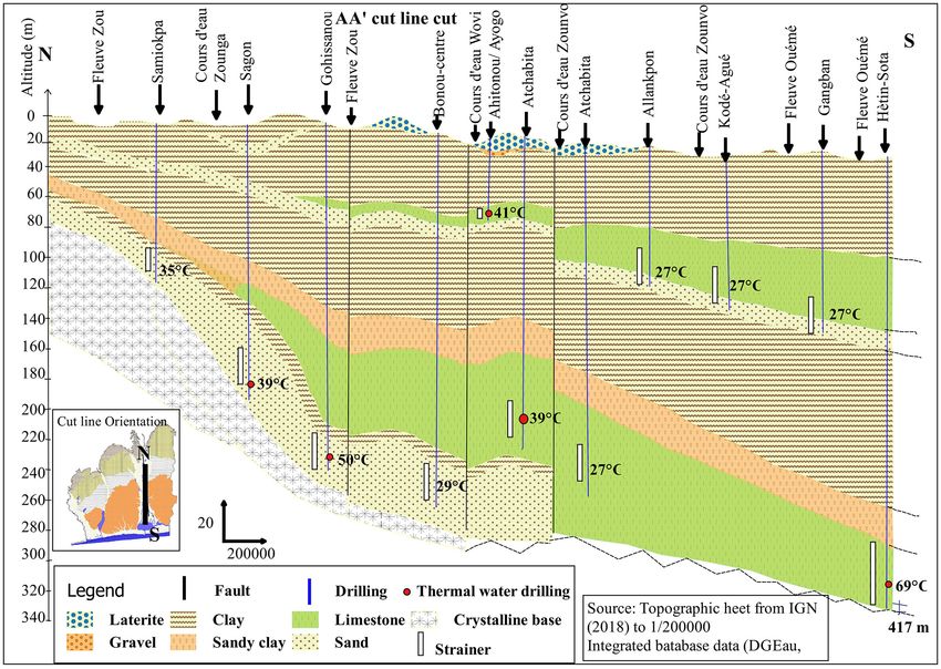
The N-S lithostratigraphic correlations of section BB' of the Couffo basin re-
veal seven types of facies in the studied area (Figure 6). They are from top to
bottom clay, laterite or bar soil, gravel, clay sand, sand and gneiss. The summit
formations are mostly represented by clays. There are a few levels of laterite some-
times. In the Northern part of the section, the localities of Affomai and Banigbe
the clays have an average thickness of about 20 meters. Conversely, in the south-
ern part of the section, from Adjame to the border of Possotomé, their thickness
goes up to 140 meters with some layers of calcareous and marl levels. At the
North of the section, the base is represented by the gneiss and located at about
70 meters depth. At the South of the section, in the localities of Agbodji, the
sands subside to a depth of 300 meters while at five kilometers from these com-
munities to the north of the section, the sands are located at an average depth of
about 60 meters. The presence of Couffo and Ahémé lake streams in the prox-
imity of the Possotomé and Eden thermal water boreholes (55˚C and 50˚C re-
spectively) and the lags observed along the section suggest the presence of a fault
system that was used to set them up.
Figure 6. North-South hydrogeological cut following BB' cut line.
4.1.2. Depth of Aquifers Captured in the BSC
Figure 7 shows the depth of the major aquifers in the coastal sedimentary basin.
It is noticeable that the depth of aquifers increases from north to south. Indeed,
the depth of the Cretaceous aquifer, which is about 40 meters in the northern
DOI: 10.4236/gep.2021.97010 157 Journal of Geoscience and Environment Protection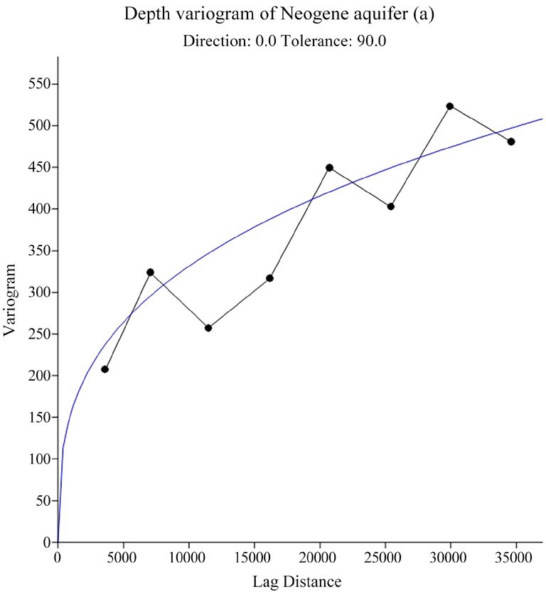
P. M. Dossou et al.

                                        zone where it outcrops, increases southwards to 280 meters under the outcrops
                                        of Paleogene marl and limestone of Lama Depression.

                      Figure 7. Aquifer depth map of the coastal sedimentary basin.

                                          The Paleogene aquifer is 80 meters deep on average in the Lama depression,
                                        where it rises to 380 meters under the clays and marls of the valleys of the main
                                        BSC Rivers. The Neogene aquifer is captured on the southern plateaus of the
                                        BSC. The depth of this aquifer is 100 meters at the north and decreases to about
                                        45 meters at the south of the plateaus.

                                        4.2. Thermal Variation of Aquifer Water in the BSC
                                        Figure 8 shows isotherm of water in the coastal sedimentary basin aquifers. The
                                        water temperatures of the major aquifers are noticed to be around 28 degrees
                                        Celsius to 34 degrees Celsius. Indeed, the temperature of the Cretaceous aquifer
                                        is about 29 degrees Celsius in the zone where it rises and 30 - 34 degrees Celsius
                                        under the Paleogene clays and marls. The temperature of the Paleogene aquifer
                                        varies between 27 and 30 degrees Celsius. In the Neogene aquifer, trapped under
                                        the southern plateaus of the BSC, the water temperature is about 28 to 30 de-
                                        grees Celsius.
                                           Although the isotherms of the main aquifers are between 28 degrees Celsius
                                        and 34 degrees Celsius, some points in these aquifers have temperatures ranging
                                        from 38 to 69 degrees Celsius. These thermal anomalies are found in the valleys
                                        of the main rivers (Figure 8).

DOI: 10.4236/gep.2021.97010                                   158              Journal of Geoscience and Environment Protection
P. M. Dossou et al.
Figure 8. Aquifer isotherm map of the coastal sedimentary basin.
4.3. Distribution of pH, Conductivity and Chemical Elements of
BSC Thermal Waters
4.3.1. pH Variation of Thermal Waters
Figure 9 illustrates the pH distribution of thermal waters in the Coastal Sedi-
mentary of Benin. The thermal waters are found to be acidic in the north (pH
between 4.8 and 5.5) and neutral to basic in the south (pH between 7.3 and 8.5).
Figure 9. Distribution of thermal water boreholes and their pH in the BSC.
DOI: 10.4236/gep.2021.97010 159 Journal of Geoscience and Environment ProtectionP. M. Dossou et al.
4.3.2. Composition in Bicarbonate, Calcium, Magnesium, Nitrate and
Ammonium Ions in the Thermal Waters of the BSC
The table below (Table 2) presents the physical and chemical characteristics of
thermal waters of the coastal sedimentary basin of Benin. It is noted that bicar-
bonate ions have a high concentration in waters collected on the southern part
of the BSC (48.2 mg/L at 85.84 mg/L). Bicarbonate ion concentration is high
from 48 mg/L to 85 mg/L in the south and low from 8 mg/L to 39 mg/L in the
North. Conversely, in the north of the BSC, calcium and magnesium have a high
concentration in the collected thermal waters. The concentration in ion Ca2+
range from 6 mg/L to 13 mg/L with exceptionally high values at Gohissanou
(47.17 mg/L), Kpokissa (57 mg/L) and Hetin-Sota (64 mg/L). On the other hand,
the composition of Mg2+ changes from 5 to 22 mg/L with an exceptionally high
value in Hètin-Sota (78.86 mg/L). The conductivity values of the captured ther-
mal waters are raised from 940 μs/cm to 1850 μs/cm in the south and low from
154 μ/cm to 170 μs/cm to the north.
Table 2. The Physico-chemical elements of thermal waters.
Physics parameters Chemical parameters (mg/L)
Locality
EC (µs/cm) pH T (˚C) HCO3− Mg2+ Ca2+ NH +4
Hetin-Sota 1850 8.40 69 85.84 78.86 64.32 1.936
Agonsa 1146 7.45 52 56.12 6.97 10.72 0.710
South of the
Possotomé 1020 7.43 55 56.12 5.23 13.58 0.890
BSC
Eden 980 7.44 50 47.58 6.97 12.87 0.425
Allounkoui 940 7.55 40 48.2 6.97 9.27 1.347
Hon 170 5.94 52 39.04 22.66 6.64 0.087
North of the
Kpokissa 154 5.48 50 8.54 16.99 57.89P. M. Dossou et al.
heat from the lithosphere through the faults (rise of the isotherms) (Trabelsi et al.
(2007) and Taillefer (2017)). The main aquifers of the BSC do not reach a depth
of 1000 meters, nor are they subject to any magmatic manifestation … The val-
leys of the main rivers of the BSC are ditches that support tectonic manifesta-
tions (Dray et al., 1989). Geomorphology plays an important role in the distribu-
tion of hydrothermal systems (Drogue, 1985; Jilali et al., 2014; Zohra et al., 2011).
Studies conducted by (IRB, 1989; Dray et al., 1989; Boukari & Alassane, 2007)
revealed deep faults system sedimentary portion of Benin. These structural fac-
tors play a key role in the genesis of thermal or mineral waters and serve as the
basis for their classification (Risler, 1971). The warm water comes from the base-
ment near the faults, which would diffuse a thermal and chemical anomaly in
the aquifer (Danis et al., 1984). Studies conducted in the Great Basin in the USA,
prove that hydrothermal systems are often linked to fragile faults and their ori-
gins are non-magmatic (Faulds et al., 2010).
The cross-sections made following the N-S directions reveal offsets in the
geological layers which result in the thermal variation of the waters collected at
Ahitonou (66 meters deep with a temperature of 41˚C) and Atchabita (deep 200
meters with a temperature of 27˚C). The continuous deformation zones are areas
of weakness that serve as a channel for heat from the lithosphere and its distri-
bution in nearby aquifers. Thus, the boreholes positioned in the areas of such
phenomena will have a higher temperature compared to those in the vicinity.
The random distribution of thermal water boreholes in the valleys of the main
BSC streams is believed to be linked to tectonic events.
Since the chemical content of the waters is the result of the rocks crossed (Ver-
noux et al., 2014), the acidic behavior of the waters collected at the north of the
BSC show that the northern part is under the influence of the basement. The
aquifer captured to the north is from the sands of the Cretaceous which is made
of major discordance at the base. On the contrary, in the South, the thermal wa-
ters have a neutral to basic pH. The high concentration of bicarbonate ion in
these waters shows that they originate in carbonate reservoirs. This higher mi-
neralization is mainly related to a solution of Sulfate chlorides originating from
attapulgite-type clay levels and sublittoral deposits containing carbonates, phos-
phates and sulphates (Dray et al., 1989).
Tectonic manifestations are believed to be the cause of the warming of the
gushing aquifers waters.
6. Conclusion
In the coastal sedimentary basin in southern Benin, the water of gushing aquifers
captured in the valleys of major rivers has high temperatures, especially in some
localities. These aquifers are made up of sands with an acid pH influenced by the
crystalline base underlying the north, and limestone, then marl with a neutral or
basic pH to the south. Clearly, the artesian phenomena of the aquifers of the val-
leys of the major streams are closely related to the topography which is a factor
DOI: 10.4236/gep.2021.97010 161 Journal of Geoscience and Environment ProtectionP. M. Dossou et al.
controlling their piezometry. The thermal water boreholes irregularly distributed
among all the water boreholes gushing from the river valleys are said to be re-
lated to fault crossings. However, this hypothesis remains to be elucidated by our
forthcoming linear studies, sedimentological and geochemical.
Conflicts of Interest
The authors declare no conflicts of interest regarding the publication of this pa-
per.
References
Adissin, G. L., Alassane, A., Dossou, P. M., Zogo, A., Ahossi, A., & Gbéwezoun, V. (2019).
Influence de la réactivation de la faille de Kandi sur le phénomène de l’artésianisme
dans le bassin versant du fleuve Mono au Sud-Ouest du bassin sédimentaire côtier du
Bénin (Afrique de l’Ouest). European Scientific Journal, 15, 403-424.
Ahossi, M. A. (2020). Vulnérabilité du Crétacé supérieur à la variabilité climatique et aux
activités anthropiques dans le bassin versant du Mono à l’exutoire de Athiémé au
Bénin. thèse de doctorat de l’Université d’Abomey-calavi, Géosciences de l’environnement
et aménagement de l’espace.
Boukari, M. (2002). Réactualisation des connaissances hydrogéologiques relatives, rela-
tives au bassin sédimentaire côtier du Benin (137 p). Direction de l’hydraulique.
Boukari, M. (2005). Aquifères côtiers de l’Afrique de l’Ouest (Bénin, Nigéria, Togo, Gha-
na, Cote d’ivoire), rapport de l’atelier national sur le document de projet regional a
moyen terme, document-guide (62 p).
Boukari, M., & Alassane, A. (2007). Les ressources en eau souterraine du bassin sédimen-
taire côtier de la république du Bénin. Africa Géoscience Review, 14, 283-301.
Danis, M., Royer, J., & Demassieux (1984). Interprétation d’une anomalie géothermique
et géochimique dans la région de Vittel-Contrexéville (pp. 305-315). Travaux de centre
de recherche pétrographique et géochimique, Hydrogéologie-géologie de l’ingénieur.
Dray, M., Giachello, L., Lazzarotto, V., Mancini, M., Roman, E., & Zuppi, G. M. (1989).
Etude isotopique de l’aquifère Crétacé du bassin sédimentaire côtier béninois.
Drogue, C. (1985). Geothermal Gradients and Ground Water Circulation in Fissured and
Karstic Rocks: The Role Played by the Structure of the Permeable Network. Journal of
Geodynamics, 4, 219-231. https://doi.org/10.1016/0264-3707(85)90061-4
Faulds, J., Coolbaugh, M., Vice, G., & Edward, M. (2010). Characterizing Structural Con-
trols of Geothermal Fields in the Northwestern Great Basin: A Progress Report. GRC
Transaction, 30, 2006.
IEA (2011). Technology Roadmap, Geothermal Heat and Power (67 p). International Energy
Agency. https://webstore.iea.org/technology-roadmap-geothermal-heat-and-power
IRB Institut de Recherche Breda (1989). Notice explicative de la carte géologique à 1/200000,
Feuille Pira-Savè, Abomey-Zagnanado et Lokossa-Porto Novo, mémoire n˚3, 1ere édi-
tion (77 p).
Jilali, A., Rimi, A., Zarhloule, Y., Ouzzaouit, L., Barkaoui, A., Antonio, C., & Carneiro, J.
(2014). Structure hydrogéothermique de la région Figuig (Haut Atlas oriental, Maroc).
Bulletin de l’Institut Scientifique, Rabat, Section Sciences de la Terre, 36, 123-134.
Kapasa, C. (2014). Evaluation of Current and Feasible Future Use of Geothermal Energy
at Chinyunyu Hot Spring, Zambia. KTH School of Industrial Engineering and Man-
agement Department of Energy Technology, EGI-2014-038MSC-EKV1026 Division of
DOI: 10.4236/gep.2021.97010 162 Journal of Geoscience and Environment ProtectionP. M. Dossou et al.
Heat and Power Technology SE-100 44 STOCKHOLM.
Lang, J., & Houessou, A. (1978). Contribution à l’étude du continental terminal terminal
dans le Bénin méridional. Bulletin des sciences géologique, 31, 137-149.
Lawin, E. (2007). Analyse climatologique et statistique du régime pluviométrique de la
haute vallée de l’Ouémé à partir des données pluviographiques, AMMA-CATCH Benin
(231 p). Thèse de doctorat préparée conjointement au laboratoire de transferts en hy-
drologie et environnement et la chaire internationale en physique mathématique et ap-
plication.
Le Barbé, L., Ale, G., Millet, B., Taxier, H., Borel, Y., & Gualde, R. (1993). Les ressources
en eau superficielle de la République du Bénin. Institut français de recherche scientifi-
que pour le développement en coopération: Collections Monographies Hydrologiques
n˚11.
Moriasi, D. N., Arnold, J. G., Van Liew, M. W., Bingner, R. L., Harmel, R. D., & Veith, T.
L. (2007). Model Evaluation Guidelines for Systematical Quantification of Accuracy in
Watershed Simulations. Transactions of the ASAE, 50, 885-900.
https://doi.org/10.13031/2013.23153
Oyede, L. M., Tossou, M. G., Kaki, C., Laibi, R. A., & Lang, J. (2006). Phénomènes enregi-
strables, milieu enregistreur et messages enregistrés: Application aux séquences biosédi-
mentaires du quaternaire récent dans le géosystème margino-littoral béninois (Afrique
de l’Ouest). Africa Géoscience Review, 13, 395-408.
Risler, J. (1971). Description et classification géologique des sources minérales et ther-
males du massif central. BRGM, Service des eaux minérales et thermales.
Slansky, M. (1962). Contribution à l’étude géologique du bassin sédimentaire côtier du
Danhomey et du Togo. Mémoire du Bureau recherche géologique et minière.
Taillefer, A. (2017). Interactions entre tectonique et hydrothermalisme: Rôle de la faille
normale de la Têt sur la circulation hydrothermale et la distribution des sources ther-
males des Pyrénées Orientales (250 p). Thèse de doctorat de l’Université de Montpel-
lier, spécialité: Sciences de la terre. https://tel.archives-ouvertes.fr/tel-01704673
Trabelsi, S., Bouri, S., & Ben Dhia, H. (2007). Contribution des approches hydrochimi-
ques et géothermométriques à l’étude des eaux thermales de la province fluorée tuni-
sienne (Nord-Est Tunisien). Revue des Energies Renouvelables CER’07, Oujda, 85-88.
Vernoux, J. F., Wuilleumier, A., & Perrin, J. (2014). Délimitation des aires d’alimentation
des captages d’eau souterraine et de leur vulnérabilité vis-à-vis des pollutions diffuses
(133 p). Rapport BRGM-63331-FR.
Zevounou, C. (1992). Géologie, quelques questions de biostratigraphie et de phosphato-
genèse des formations Cénozoïques de la Baie du Bénin. Thèse de doctorat de l’Université
Russe de l’amitié des peuples de moscou, Géologie et prospection des minéraux utiles.
Zevounou, C., Kaki, C., Laibi, R. A., & Oyede, L. M. (2012). Caractéristiques pétro-stra-
tigraphiques et conditions de genèse des phosphates dans le bassin sédimentaire côtier
du Bénin (Golf du Bénin). Africa Géoscience Review, 19, 59-67.
Zohra, F., Haouchine, B., Boudoukha, A., & Haouchine, A. (2011). Hydrogéochimie et
géothermométrie: Apports à l’identification du réservoir thermal des sources de ham-
mam righa, algérie. Hydrological Sciences Journal, 57, 1184-1195.
https://www.tandfonline.com/loi/thsj20
https://doi.org/10.1080/02626667.2012.694448
DOI: 10.4236/gep.2021.97010 163 Journal of Geoscience and Environment ProtectionYou can also read