Planning Statement The Town and Country Planning (General Permitted Development) (England) Order 2015
←
→
Page content transcription
If your browser does not render page correctly, please read the page content below
Planning Statement
The Town and Country Planning (General Permitted Development) (England)
Order 2015
CHANGE OF USE OF RESIDENCE FROM CLASS B1(A) OFFICES TO CLASS C3
RESIDENTIAL (DWELLING HOUSE)
12 ST. ANDREWS ROAD, SURBITON, KT6 4DT
STATEMENT IN SUPPORT OF THE APPLICATION 29 JUNE 2015
Introduction
This Statement accompanies a Class O application for prior approval for change of use of
the house from Class B1(a) (offices) to Class C3 (dwelling house) at 12 ST. ANDREWS
ROAD, SURBITON, KT6 4DT (‘the Property’).
This statement also refers to an email from Planning Enforcement Officer Mr Paul Young
“the Officer” dated 26 June 2015.
The Proposal
The proposed change of use is considered ‘permitted development’ under Class O (changes
of use) of the Town & Country Planning (General Permitted Development) Order 2015.
The application is submitted in accordance with the Order which sets out the procedures for
applications for prior approval. This requires a developer to make an application to the LPA
for determination as to whether the prior approval of the authority will be required.
The Application
The Officer has stated the email dated 26 June 2015 that the application which can be
submitted on line or in writing must consist of:
1) Evidence of office use on the 29 May 2013. Emails between the Samaritans and The
Royal Borough of Kingston upon Thames demonstrate that this evidence has been provided
and confirmed as within B1.
The council has therefore received this evidence however the applicant has also provided
this in support of the application.
2) The application form for proposed change of use
3) An original online 1:250 Scale Ordnance Survey and Site Location Plan
4) Existing and proposed scales floor plans. Existing will be provided – there are no
proposed changes to the floor plans.
5) Plans for onsite parking. The current onsite parking would not meet regulations therefore
it is not currently possible to provide onsite parking.
6) Supporting Statement. This is the purpose of this document. This should address three
points. The Officer states “It is not in a flood risk zone and there are no records of any
toxic activities on the land so this should be brief. You need to focus on the highways
impact as discussed (comparing the current and future situation)”
7) A fee of £80
1.0 Permitted Development
O. Development consisting of a change of use of a building and any land within its curtilage
from a use falling within Class B1(a) (offices) of the Schedule to the Use Classes Order, to a
use falling within Class C3 (dwellinghouses) of that Schedule.
Development not permitted
O.1 Development is not permitted by Class O if—
(a) the building is on article 2(5) land;
The Officers response is “your site is not on Article 2(5) so this is irrelevant – no
action
(b) the building was not used for a use falling within Class B1(a) (offices) of the Schedule to
the Use Classes Order—
(i) on 29th May 2013, or
(ii) in the case of a building which was in use before that date but was not in use on that
date, when it was last in use;
Emails between Mr Steve Thwaite (consultant for The Samaritans) and Mr David Horkan –
(Interim Group Manager, Development Management Royal Borough of Kingston Upon
Thames) have considered the supporting information provided by The Samaritans.
The conclusion (email from Mr Horkan dated 5 May 2015) is
“I have now looked into this and read through your supporting information.
With the benefit of this clarification I would agree that the lawful use would appear to
fall within Class B1.”
(c) the use of the building falling within Class C3 (dwellinghouses) of that Schedule was
begun after 30th May 2016;
The Officers response is “Irrelevant for application (it sets a completion date)”
(d) the site is, or forms part of, a safety hazard area;
The Officers response is “Irrelevant as it is not in a safety hazard area”
(e) the site is, or forms part of, a military explosives storage area;
The Officers response is “Irrelevant as a military storage area”
(f) the building is a listed building or is within the curtilage of a listed building; or
The Officers response is “Irrelevant as no part of the site is listed”
(g) the site is, or contains, a scheduled monument.
The Officers response is “Irrelevant as there are no scheduled monuments”
Conditions
O.2 Development under Class O is permitted subject to the condition that before beginning
the development, the developer must apply to the local planning authority for a determination
as to whether the prior approval of the authority will be required as to—
(a) transport and highways impacts of the development;
(b) contamination risks on the site; and
(c) flooding risks on the site,
and the provisions of paragraph W (prior approval) apply in relation to that application.

2.0 Transport and Highways Impacts of the Development
2.1 The Order requires the LPA to consult as follows where, in its opinion, the development
is likely to result in a material increase or a material change in the character of traffic in the
vicinity of the site -
                                   – where the increase or change relates to traffic entering
or leaving a trunk road. St. Andrews Road is not a trunk road and is not a classified road.
                             - where the increase or change relates to traffic entering or
leaving a classified road or proposed highway. See below.
                                  - where the increase or change relates to traffic using a
level crossing over a railway. There is no railway crossing nearby.
2.2 The following paragraphs assess whether the development is likely to result in a material
increase or material change in the character of traffic in the vicinity of the site in terms of
traffic entering or leaving a classified road: -
Accessibility of the site
2.3 The Property is in a sustainable urban location and provides opportunities for non car
modes of travel. There is a variety of local shops, pubs and cafes within easy walking
distance (less than 250 metres). These include newsagents, off license, cafe,
restaurant/takeways, convenience stores, grocers, printers, a betting shop, hair salons,
public houses, a place of worship and supermarkets.
2.4 Surbiton town centre is about 200 meters walking distance and provides a range of
convenience and comparison shopping and services. There are doctor’s surgeries, primary
and junior schools and public library all within 1 kilometer of the Property.
2.5 The Property is about 200 meters (3 minutes) walking distance from Surbiton railway
station which provides regular services between London Waterloo, Basingstoke, Guildford
and Hampton Court.
2.6 St. Andrews Road has 11 bus stops within a 5 minute walk which are served by 16 bus
routes to Chessington, Claygate, Epsom, Esher, Hook, Hounslow, Kingston, New Malden
and Twickenham.
TRICS data on comparative traffic flows
2.7 TRICS data indicates that B1(a) offices would typically generate about 14 daily vehicle
movements per 100 sq m, with hourly flows of 1.6 vehicle movements per 100 sq m in the
am peak and 1.4 vehicle movements per 100 sq m in the pm peak. On this basis the existing
B1 office use (260 sq m GEA) would generate about1:
daily vehicle movements
4 morning peak movements
3.5 evening peak movements
2.8 By comparison the TRICS database suggests that private residence would typically
generate about 7 daily vehicle movements and 0.66 vehicle movements in the am peak and
0.70 vehicle movements in the pm peak respectively. In the figures below we have used the
higher rates than the suggested figures for am and pm peak hour for this assessment.
2.9 The based on the TRICS figures (conservative case) figures proposed house would
generate:-
7 daily vehicle movements
1 morning peak movements
1 evening peak movements
However the average car ownership in the borough is 1.2 per household and the proximity of
public transport high thus making the TRICS estimates appear to be high for the given
scenario.
2.10 The residential conversion therefore would result in reduced vehicle movements daily
or during peak hours and indeed would offer a significant reduction in peak flows. The
proposal would not result in a material increase or a material change in the character of
traffic in the vicinity of the site.
Other trip generation estimates (The Employment Densities Guide 2nd Edition (2010)
published by Drivers Jonas)
Deloitte identifies B1(a) office floor space ratio of 12 sq m NIA per employee.
The existing office floor space of 260 sq m therefore has a capacity for about 21 employees.
By comparison the proposed residence is estimated to have a likely occupancy of about 2.5
residents overall based on typical London occupancy ratios (20112). Not all households may
own a car given the proximity and accessibility to public transport, shops and services.
2.12 This is further indication that the proposed change of use will not result in a material
increase or a material change in the character of traffic of traffic in the vicinity of the site,
particularly having regard to NPPF para 32 that development should only be prevented or
refused on transport grounds where the residual cumulative impacts are severe.
1
These current figures are likely to be much higher for example the present occupants - The Samaritans are
operate a 24 hour, 365 days a year service using part time volunteers and not standard business hours and
work patterns assumed by TRICS
2
Housing in London 2014: The evidence for the Mayors Housing Strategy Published by the GLAParking
2.13 Currently the existing occupants - The Samaritans, hold four business parking permits
that are interchangeable to support their core workforce. In addition the area needs to
accommodate their additional 20+ volunteers who fill-in on an ad-hoc basis sometimes
sharing shifts. This clearly would be substantially reduced by the change to a single
household residence where the average car ownership per household in the Surrey area is
1.2 cars per household3.
2.14 However, the level of provision of parking space consistent with the London Plan and
the Kingston Council’s standard is 0.66 of a space cannot currently be provided within the
property without a drop curve. Under the current regulations the parking area (known as the
hard-standing) needs to be greater than 4.57 metres in length, measured at right angles to
the highway and 2.4 metres in width. There is a hard standing in the front of the property
that could satisfy this requirement. However the applicants does not seek to delay the
application by including this within the application. It is simply presented as an option for the
council.
2.15 The comparison figures indicate that C3 residential use would result in decreased
vehicle movements compared to the existing B1(a) office use. This suggests that general
parking demand would decrease significantly as a result of the proposed residential use.
2.16 The level of provision of parking space consistent with the London Plan and the
Kingston Council’s standard is 0.66 of a space cannot currently be provided within the
property without a drop curve. Under the current regulations for a drop curve the parking
area (known as the hard-standing) needs to be greater than 4.57 metres in length, measured
at right angles to the highway and 2.4 metres in width.
Alternative Parking
2.17 Parking restrictions apply in the area and resident’s permits are issued to address this.
Without parking permits there is only short term parking available on meters and in car
parks.
3
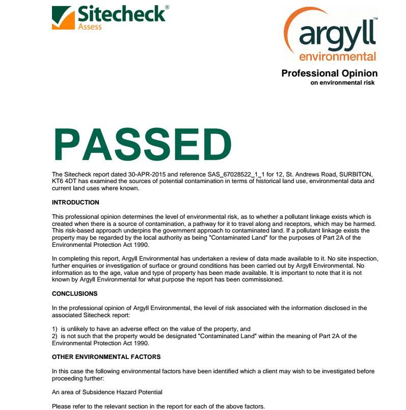
Based on Surrey census figures 20113.0 Contamination Risks on the Site A summary of the Sitecheck Environmental Report (30th April 2015) by Argyll Environmental is shown below (a Summary Table: Environment) and the full report can be provided if required. 3.1 The Order requires LPA to determine whether, as a result of the proposed change of use, taking into account any proposed mitigation, the site will be contaminated land as described in Part 2A of the Environmental Protection Act 1990. 3.2 Part 2A of the Environmental Protection Act 1990 Section 78A(2) defines contaminated land as land in such a condition that (a) significant harm is being caused or there is a significant possibility of such harm being caused, or (b) significant pollution of control waters is being, or is likely to be, caused. 3.3 Sitecheck Report Conclusion Summary Table: Environment Searches
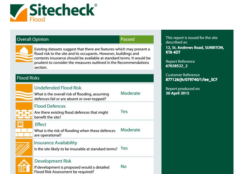
4.0 Flooding Risks on the Site
A Sitecheck flood report (30th April 2015) summary shown below (a Summary Table: Flood
Risk) and the full report can be provided if required.
4.1 The Order requires the LPA to consult the Environment Agency where the development
is –
(a) in an area within Flood Zone 2 or Flood Zone 3; or
(b) in an area within Flood Zone 1 which has critical drainage problems and which has been
notified to the LPA by the Environment Agency for the purposes of paragraph (ze)(ii) in the
Table in Schedule 5 to the Town & Country Planning (Development Management
Procedure) (England) Order 2010.
4.2 The proposal is not considered one that requires consultation in accordance with the
Order:
(1) The site lies within Flood Zone 1 (low risk) as shown on the Environment Agency’s Flood
Map.
(2) We understand the site is not identified within a Critical Drainage Area notified to the LPA
by the Environment Agency.
(3) The proposal involves no external works and will not increase flood risk elsewhere.

Summary Table: Flood Risk
Conclusion

    The application seeks prior approval for change of use from B1(a) (offices) to C3
    (dwelling house).
    The property was in use as offices by The Samaritans on 29 May 2013. This
    requirement has been already verified as satisfied by the information provided to David
    Horkan from The Samaritans in May 2015. The supporting documentation is provided
    with this application.
    The proposal meets the requirements of the Order. The proposal will not result in any
    transport or highway impacts, contamination risks or flooding risks. It is therefore
    considered that the proposal is permitted development under Class O of the Town &
    Country Planning Act (General Permitted Development) (England) Order 2015.

Appendix - Correspondence from the Samaritans which lead to the decision to classify the
property as B1 (a)

------- Original Message --------
Subject:Kingston Samaritans
   Date:Tue, 28 Apr 2015 10:53:01 +0100
  From:Steve Thwaites
    To:bruce.mcdonald@kingston.gov.uk, lynda.collis@kingston.gov.uk

Dear Mr McDonald,

I am acting on behalf of the Kingston Samaritans who would welcome your
assistance.

I am sure you are aware of the Samaritans and the public service they
provide to the community.
The local branch have been operating from the same premises in Surbiton
since 1967.
Those premises are not only needing substantial repair but they are no
longer really suitable for the Samaritans purposes.
Modern day life is changing and the Samaritans also need to adapt and
find a new centre.

They are aware of the constraints on public expenditure and have been
trying to devise a self-funded relocation project.
At the heart of this strategy has been the need to be able to sell their
current premises for residential use. This seemed a reasonable prospect
bearing in mind the premises were originally a house and the premises
are located in a residential area.

However the planning officers have looked at the proposal in a way which
raises substantial obstacles.

I have been asked to assist and advise. I am attaching a background
note from the Samaritans which sets out the detail about 'why' and 'how'
they hope to fund their relocation. Please note that they are not
intending to leave the area! In addition as a registered charity they
have a duty to ensure that any proceedings are ploughed straight back into their charitable activities. They need to remain local to deliver their service. I am also attaching a copy of my own note to them, which explores the specific planning issues. Can you assist them with advice or any other suggestions to help get this important project back on track? The spirit of this approach is not a complaint but to see whether your corporate role could help broker a solution that would assist the Samaritans with their objectives. We are happy to provide any further information or to attend any meetings to do our part! It would be helpful if you could confirm safe receipt of this email - thanks. Kind Regards Steve Thwaites -- Steve Thwaites Director Cogito Consulting Ltd 01483 760086
You can also read