Port Fairy Bicycle Implementation Strategy - Draft Report Prepared for Moyne Shire Council - Moyne Shire ...
←
→
Page content transcription
If your browser does not render page correctly, please read the page content below
Port Fairy
Bicycle Implementation Strategy

                                                                          T
                                                                       AF
                                                                    DR

Draft Report
Prepared for Moyne Shire Council
September 2021

Tract               Level 6, 6 Riverside Quay,   (03) 9429 6133.                          Issued
                    Southbank VIC 3006           www.tract.com.au             06 September 2021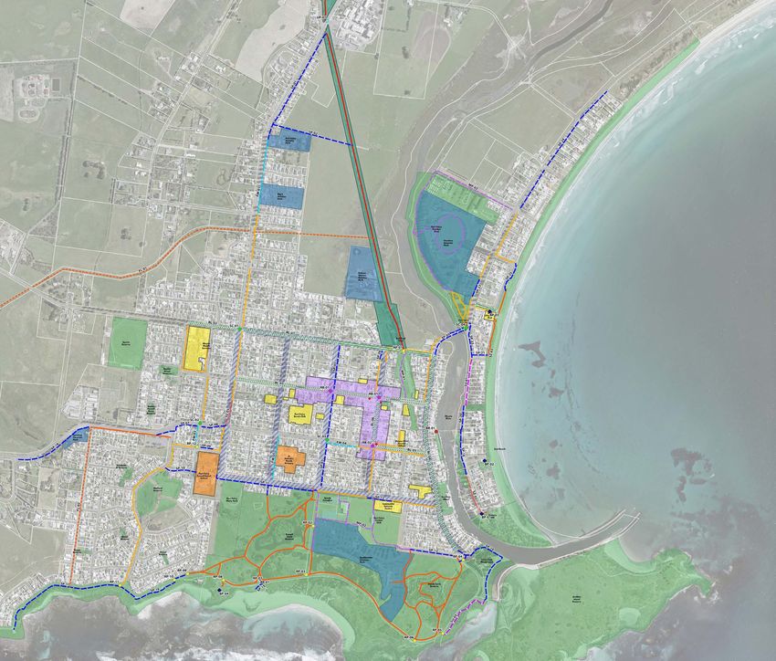
Quality Assurance

Port Fairy Bicycle Implementation Strategy   Prepared for                                                                   Project Number
Draft Report                                 Moyne Shire Council                                                            321-0154-U-03-RP01

Revisions

Issue               Date                     Description                                                                                         Prepared By          Reviewed By   Project Principal
00                  06 September 2021        Preliminary Draft                                                                                   MN                   MN            MN

                                                                                                T
01                  09 September 2021        Draft for community engagement                                                                      MN                   MN            MN

                                                                                             AF
                                                                                          DR

Tract                                        321-0154-00-U-01-RP01_Port Fairy Bicycle Implementation Plan Strategy Report                             06 September 2021                            02 / 15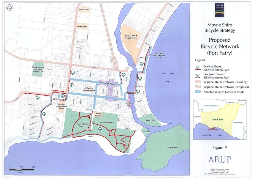
Contents

1       Introduction                                                                                                                      04

        1.1    Project Overview                                                                                                           04
        1.2    What are we aiming for?                                                                                                    04
        1.3    Who are we planning for?                                                                                                   04

2       Existing Strategies & Master Plans                                                                                                05

        2.1    Moyne Bicycle Strategy, 2000                                                                                               05
        2.2    Southcombe Park Master Plan                                                                                                06

                                                                                                                    T
        2.3    Railway Place Precinct Plan                                                                                                06

                                                                                                                 AF
        2.4    Port of Port Fairy Master Plan                                                                                             06
        2.5    East Beach Masterplan                                                                                                      07
        2.6    Gardens Reserve Master Plan                                                                                                07

                                                                                                              DR
3       Existing Bicycle Infrastructure in Port Fairy                                                                                     08

4       The Bicycle Implementation Strategy                                                                                               10

        4.1    Overview                                                                                                                   10
        4.2    Proposed Bicycle Links                                                                                                     12
        4.3    Proposed Cycling Safety Improvements                                                                                       13
        4.4    Proposed Bicycle Parking and Repair Facilities                                                                             13

5       Criteria for Implementation Priority                                                                                              14

Tract                                                            321-0154-00-U-01-RP01_Port Fairy Bicycle Implementation Plan Strategy Report   06 September 2021   03 / 15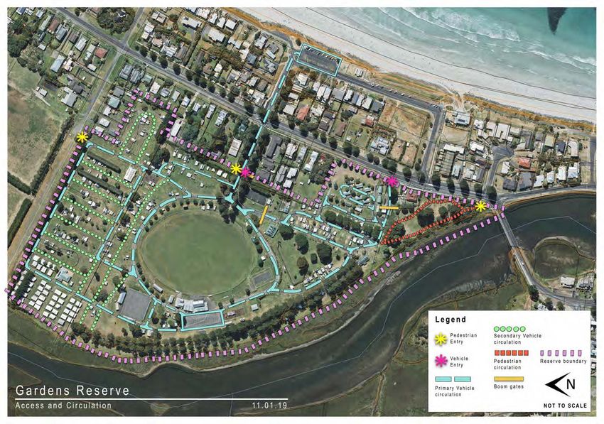
1         Introduction

1.1       Project Overview                                                           1.2       What are we aiming for?

The Port Fairy Bicycle Implementation Strategy seeks to                              Cycling provides a range of health, social, environmental
strengthen the bicycle network and supporting infrastructure                         and economic benefits to individuals and the community. The
across Port Fairy. It builds on the Moyne Bicycle Strategy                           2021-2025 Moyne Shire Council Plan recognises the benefits
developed in 2000, which established a network of priority                           of walking and cycling across the shire, and aims to create
cycling routes within the Port Fairy township and regional links                     connected and active communities through an enhanced
beyond the township.                                                                 walking and cycling network
The bicycle network in Port Fairy plays a critical role providing                    The Port Fairy Bicycle Implementation Strategy builds on this
local access to key destinations across town and supporting                          and aims to:
the 237,133 tourists that visit annually1. Establishment of a
                                                                                     ·     Provide a network and infrastructure that caters to a range
connected, convenient and safe cycling network will ensure
                                                                                           of cyclists.
Port Fairy continues to grow as a tourism destination and also a
desirable location for existing and future residents.                                ·     Connect locals to origins and destinations.
                                                                                     ·     Strengthen the tourism offer of Port Fairy.
Since the development of the 2000 Moyne Bicycle Strategy
                                                                                     ·     Provide for a high level of safety and comfort.
there has been significant residential and commercial
development of Port Fairy which has influenced the demand                            ·     Provide safety infrastructure for cyclists at vehicle conflict

                                                                                                                                        T
on the cycle network and community expectations regarding                                  points.
transport. There has also been notable population growth and                         ·     Maximise the landscape experience.

                                                                                                                                     AF
infrastructure improvements which can be further expanded on.                        ·     Respond to the special heritage and landscape character
                                                                                           of Port Fairy.
The Bicycle Implementation Strategy identifies a range of
shared walking and cycling paths, and on-road bicycle lanes                          1.3       Who are we planning for?
to create a comprehensive network connecting cyclists to key

                                                                                                                                  DR
destinations. It recommends a number of safety improvements
at key intersections across Port Fairy to ensure cyclist priority                    A good cycling network will cater to a range of cyclists with
and safety is maximised. It also provides recommendations for                        varying levels of abilities and confidence.
bicycle parking and repair facilities across the township.
                                                                                     Figure 1 prepared by Austroads, identifies the various types of
The Implementation Strategy has been developed by Tract                              cyclists and their characteristics and riding environments.
Consultants and Wallbridge Gilbert Aztec. It has been
                                                                                     The Bicycle Implementation Strategy seeks to provide a
informed by Moyne Shire Council Officers and the Project
                                                                                     network that caters a range of cyclists with varying levels
Working Group, which included representatives from the Port
                                                                                     of confidence and ability. The strategy aims to make the
Fairy Bicycle Users Group, the Port Fairy to Warrnambool Rail
                                                                                     network safer and more convenient for confident cyclists
Trail Committee and the Port Fairy Consolidated School.
                                                                                     through the introduction of on-road bike lanes and intersection
                                                                                     safety improvements. It also provides a range of new shared
1 Urban Enterprise, Port Fairy Coastal & Structure Planning Project - Economic and
Tourism Land Use Analysis, Issues and Opportunities Report (2016)                    pathways connecting people to schools and open space,
                                                                                     which are suitable for less experienced cyclists.

                                                                                                                                                                    Figure 1.   Cyclists Categories (source: Austroads Guide to Traffic Management Part 4, 2016)

Tract                                                                                321-0154-00-U-01-RP01_Port Fairy Bicycle Implementation Plan Strategy Report                                                                                    06 September 2021   04 / 15
2       Existing Strategies & Master Plans

There are a range of existing strategies and master plans
that have influenced the development of the Bicycle
Implementation Strategy. These documents are summarised
as follows:

2.1     Moyne Bicycle Strategy, 2000

The Moyne Shire Bicycle Strategy 2000, identifies the existing
bike paths and attractors within Port Fairy and some of the
design considerations for intersections, signage and future
paths.
It proposed a number of shared paths connecting residents
to key destinations. Some of these paths have since been
implemented, including the shared path along Powling Street.
The strategy identified a regional cycling network, which was

                                                                                                                       T
intended to provide broader connections across the Moyne
Shire. The Port Fairy to Warrnambool Rail Trail was identified

                                                                                                                    AF
as a regional link, which has since been implemented.
Similarly, Regent Street was identified as another regional links
and is currently being upgraded with on-road bike lanes.
Within the town centre, the Strategy identified James Street,

                                                                                                                 DR
Bank Street and Cox Street as key streets for the bicycle
network.

                                                                    Figure 2.   Moyne Bicycle Strategy, 2000 - Proposed Bicycle Network in Port Fairy

Tract                                                               321-0154-00-U-01-RP01_Port Fairy Bicycle Implementation Plan Strategy Report        06 September 2021   05 / 15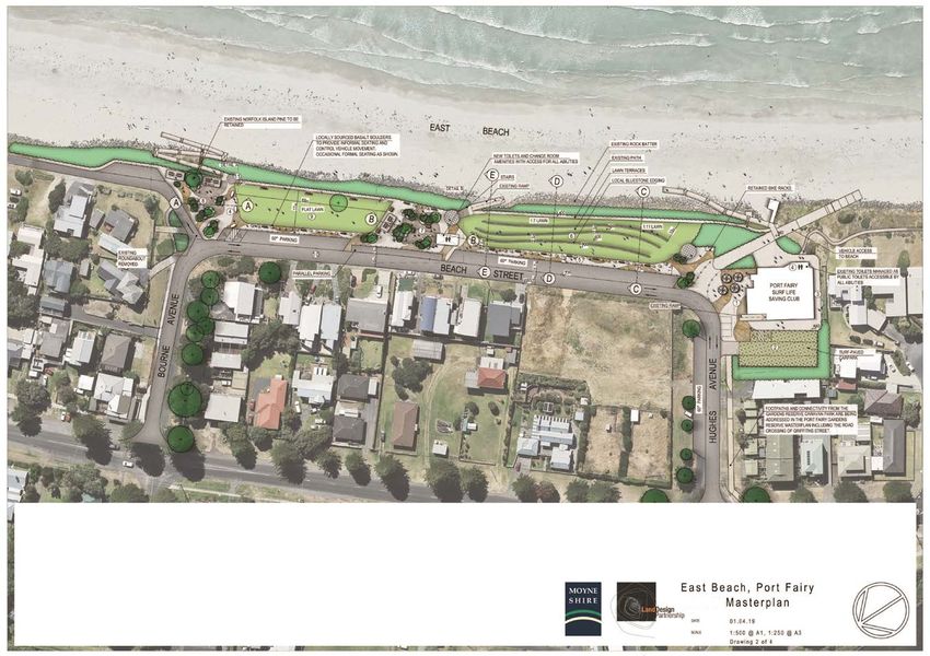
2.2 Southcombe Park Master Plan 2.3 Railway Place Precinct Plan
The Southcombe Park Master Plan seeks to upgrade The Railway Plan Precinct is located between Regent Street
various facilities including, tennis, netball, indoor cricket and and Bank Street as the western edge of the town centre. The
surrounding playing fields. This will create it as a stronger Master Plan provides for the enhancement of the Precinct as
destination in Port Fairy and improved bicycle access to the a key destination in Port Fairy with additional community and
Park will be important. commercial uses and re-use of the Goods Shed as a multi-
purpose events space.
The Masterplan identifies a primary and secondary path
network within the park which have been considered in the The Masterplan also proposes the extension of the rail trail
development of the Port Fairy Bicycle Implementation Strategy. through the precinct connecting into Bank Street and with an
opportunity to link further through to the port and bridge.
RECOMMENDATIONS CONTINUED PLAN LEGEND 2.4 Port of Port Fairy Master Plan
Management & Maintenance:
Proposed mixed use courts
Southcombe Park Management Committee (SPMC):
20 The SPMC has been a highly effective management committee Redeveloped tennis courts
operating on behalf of Council. The committee should continue to
retain reasonability for ongoing management of the reserve,
however a closer relationship with Council may be required in order
to ensure ongoing compliance with S86 Committee legislative Proposed secondary path network
requirements for reporting and governance. Council must clarify
The Port of Port Fairy is as a key destination within Port Fairy.
reporting and record keeping requirements and assist the
committee to achieve these. Proposed primary path network
Moyne Shire:
Upgraded informal carparking
21 Council’s role in relation to ongoing management of the Southcombe
The master plan provides pedestrian links on the eastern side
Park Recreation Reserve should primarily focus on supporting the
SPMC and assisting with funding of major projects and initiatives Existing buildings & structures
(either direct funding support and/or assist in securing external
grants/funding).
Indicative proposed trees
Belfast Aquatics & Stadium:
22 Council to assist the SPMC to establish effective Asset Management
Plans for key assets, facilities and infrastructure in the reserve,
including updating the 2007 Building Condition Compliance Audit.
Proposed lighting
of Moyne River to connect East beach and Battery Hill. The
T
Ensure the Asset Management Plans are linked to a dened program
of annual works and clearly articulate ongoing maintenance Proposed community open space/informal
masterplan proposes multiple open space improvements
responsibilities. recreation/overow parking
Maintenance:
Primary areas for community revegetation
23 Ensure an effective program of drainage maintenance (including and replanting program
dredging and pipe clearing as required) to maintain effective
throughout, such as George Square and new riverside open
drainage and environmental ow in George Dodd Reserve and
Sandy Cove.
Proposed areas of improved ground surface
AF
conditions
Senescient trees to be removed
Proposed upgraded fence
SOUTHCOMBE PARK MASTER PLAN - MAY 2016 16
space at the scout hall location.
The Master Plan does not propose any cycling links however
it does create the Port as a stronger destination for cyclists and
Figure 4. Railway Place Precinct Master Plan
there are opportunities to better connect into the Port.
DR
P O R T O F P O R T F A I R Y | DRAFT MASTER PLAN
5 Provide interpretive signage
Scale 1:1500 @ A1 and amenities (seats etc) at
Battery Hill high point
Investigate 6m extension to floating pontoon to
allow for both Marine Rescue Service Vessel and Sail GRIFFITHS ISLAND
ability sessions
11
16
Through the main port
BATTERY HILL
management/operations area, this path should LITTLE EAST BEACH
take one of two options; Along Griffiths St or in a 8
shared pedestrian/vehicle space along Battery
Lane
10
3 15
MARTINS POINT
4
INFORMATION/
PORT FAIRY YACHT INTERPRETATION SIGNAGE
CLUB 1 East Beach, Town Centre, Battery
6 Hill, Port Fairy Botanical Gardens
9 2
Figure 3. Southcombe Park Master Plan Griffiths St Oc
ea
2 East Beach, Town Centre, Martins
Point, Wharf
n
Rd
3 Moyne River, Boat moorings, Town
13 18 Centre
17
R WHARF RESTAURANT 4 Martins Point, Footbridge, boat
E RI VE
M O YN SANDY COVE RESERVE moorings
12
17 7 5 Martins Point, Griffiths Island, Toilet
Blocks, Picnic Area
6 Battery Hill, Magazine, Cannons
Gi pp s
St 7 Battery Hill, Little East Beach
8 Little East Beach, Battery Hill
ACCESS/CIRCULATION LANDSCAPE AND OPEN SPACE 8 Undertake general upgrade of Martins Point PORT AND WATERWAY Investigate extension of fixed jetty to
RECOMMENDATIONS RECOMMENDATIONS landscape amenity including playground upgrade RECOMMENDATIONS 15 provide additional mooring
in accordance with draft design
Provide formal pedestrian path along Enhance Battery Hill landscape and Prepare asset assessment and
1 5 11 Investigate extension of fixed jetty to
eastern side of Moyne River, connecting amenity through path maintenence and
9
Enhance the landscape amenity of Charles Miller management plan and gradually 16 provide additional temporary recreational
to footbridge with East Beach/Port Fairy management, on-going revegetation with Park with park furniture, shelters, planting and a reconstruct training walls as required,
moorings and recreational fishing
Botanic Gardens and Battery Hill indigenous species, weed control, seating formed perimeter walking track linked to river utilising traditional materials and methods
and signage at key points of interest along edge.
Provide formal marking of parking spaces path systems etc 12 Investigate fresh fish sale area 17 Maintain private berths
2 Develop picnic/barbecue area with shelters,
and clear direction of traffic flow
6 Remove Sea Scouts Building and develop 10 seats, amenity planting and signage explaining Focus active commercial berths in the
Investigate additional private mooring
area as new riverside open space, with Battery Hill and Moyne River history and 13 berths
18 area immediately adjacent to King George
Provide line marked parking spaces to potential for overflow parking at peak times
3 utilies avaible space efficiency
environment in accordance with heritage controls Square
Provide permanent mooring for Marine
Develop open space amenity in King Develop and implement an integrated signage 14 Pedestrian Path links
Formalise car park at end of Griffiths St,
7 George Square to support Wharf system promoting key Port features and directing
Rescue Service vessel, consider
upgrading of floating pontoon to provide
4 and provide signage to indicate entrance Restaurant and Port activity through to other points of interest: Battery Hill, East security and ease of access. Mooring to
85
to Battery Hill and walking path provision of planting, seats and interpretive Beach, Port Fairy Botanic Gardens, boat ramp, be available for Sail-ability and other
signage, as well as informal lawn Town Centre, Griffiths Island periodic users
Figure 5. Port of Fairy Master Plan
Tract 321-0154-00-U-01-RP01_Port Fairy Bicycle Implementation Plan Strategy Report 06 September 2021 06 / 15
2.5 East Beach Masterplan Att04. Final East Beach Master Plan, Page 2 of 5
East Beach is a popular location for locals and visitors with a 1. Potential Planting such as Banksia Marginata to be
Planted to Retain Views
7/8. Potential Informal Seating within Central Node,
All Abilities Node + along Promenade
7/8. Potential Sculptural Seating within Central +
All Abilities Node
7/8. Potential Sculptural Seating/Bollards within Central +
All Abilities Node
5. Potential Exposed Aggregate Concrete Pavement 5. Potential Pavement Pattern Example 6. Potential New Terraced Lawn with Bluestone seating
and Bluestone terraces
7/8. Potential Sculpture Bollards
patrolled beach for swimming.
The Masterplan seeks to provide new public spaces within the
foreshore reserve and additional facilities. It identifies a 3-4m
wide promenade along the Beach Street edge however it is
not clear if this is a shared space for pedestrians and cyclists.
2.6 Gardens Reserve Master Plan
The Garden Reserve Masterplan provides for the further
enhancement of the sports precinct along with the extension of
adjoining caravan/camping features within the reserve.
It identifies a broader connection network beyond the reserve
including the establishment of a pathway along the Moyne 1. The reconguration of the Beach Street/Hughes Avenues intersection will create a broad Plaza at the entry to the Port Fairy Surf Life Saving Club. This Plaza will connect with the Promenade to create a public space suitable for marquees, food vans, cafe tables and 8. All Abilities Node - This space has been located to take advantage of the proposed all-abilities beach access. It will provide seating, dining areas and amenities suited to
informal performances, while allowing for required vehicle access. all abilities. The area will be supported by nominated disabled parking.
River.
T
2. A new car park will be constructed on the existing vacant council land to the west of the Surf Club. This car park will replace the existing car park removed to create a new lawn to the north of East Beach. The car park will provide disabled parking with direct access to all 9. New lawn - A new at open lawn will be provided by relocating existing car parking to new parking on Hughes Avenue. Refer to note 10 for total parking numbers.
abilities beach access and amenities. Refer note 10 for total parking numbers.
10. Roads and Parking - Beach Street and Hughes Avenue will be formalised and slightly re-aligned to provide additional parking and pedestrian areas. The roads will be
3. A DDA compliant access path will be provided from the new public car park to the existing beach access ramp (which is current not accessible for those with limited ability). re-grade to drain away from residential properties. Existing Parking in Precinct: 67 formal spaces, 48 (approx) informal spaces = Total 115 spaces
Proposed Parking in Precinct: 116 formal spaces, 10 (approx) informal spaces = Total 126 spaces
4. Utilise existing Surf Club toilets as public toilets accessible by all abilities
There are opportunities to improve bicycle access to this
AF
11. Lookout - locations will be established at each of the key spaces along the East Beach foreshore. These lookouts will be oriented towards key features of the Port Fairy
5. A broad pedestrian space will link the Central Node with the Surf Club Plaza. The Promenade will be paved with a patterned textured pavement incorporating seating and sculptural bollards. The pavement will be broad enough to support food vans occasional market stalls coast with signage to tell the story of its environment and history. This signage will be coordinated with other key locations around Port Fairy.
and so on.
important reserve. 6. A new terraced lawn area will be created through the removal of the existing crushed rock path angled across the existing lawn. This will allow the existing steep gradient to be modied to provide gently sloping lawns separated by bluestone seating terraces. Together the
Att01. Gardens Reserve Master Plan March 2019, Page 51 of 54
gentle lawns and terraces will provide seating opportunities which are currently not available. Including a DDA compliant access path will be provided from the new public car park to the existing beach access ramp (which is currently not accessible for those with limited ability).
7. Central Node - This will be a space for socialising and quietly appreciating the coastal landscape. The space will have an environmental expression with elements such as local vegetation, a sculpture garden and informal seating and gathering opportunities. It will also
have formal shelter, picnic tables and barbecue, located to take advantage of views to the north and the south. This will contribute to East Beach as an environmental focus to compliment Gardens Reserve as a recreation focus and the wharf as a maritime history focus.
Appendix 2
Figure
Plan6.Showing Reserve
East Beach Access and Circulation Features
Masterplan
DR
Figure
Moyne7.Shire GARDENS
GardensRESERVE
Reserve MASTER
Master PLAN
Plan 2019 Appendices
Tract 321-0154-00-U-01-RP01_Port Fairy Bicycle Implementation Plan Strategy Report 06 September 2021 07 / 15
3        Existing Bicycle Infrastructure in Port Fairy

 Figure 8 identifies existing bicycle infrastructure in Port Fairy as    · Griffiths Street is a key cycling connection providing
                                                                        11
 well as key destinations within the township.                             access to the waterfront, beach and Battery Hill. It lacks a
                                                                           suitable cycling connection with narrow and discontinuous
 A summary of existing bicycle infrastructure, key opportunities           pathways. The road reserve is also narrow making it
 and constraints is provided below:                                        challenging to install new cycling infrastructure.
1· Existing bicycle infrastructure is generally limited across          12
                                                                         · Campbell Street includes a number of recreational facilities
   Port Fairy. There are a range of destinations across Port               and open space however it lacks a continuous cycling
   Fairy that could be better connected for cyclists.                      link. There may be an opportunity to provide a link along
2· The Port Fairy to Warrnambool Rail Trail is a significant               this street that better connects the schools and residents to
   cycling asset that is valued by residents and tourists. The             these facilities.
   crossing at the Princes Highway is a dangerous location               · The Gipps Street Bridge is an important cycling connection
                                                                        13
   for cyclists because of the high volumes of traffic and                 however it does not have any cycling lanes or pathways
   vehicle speeds. There are current plans to extend the trail             and the road pavement is narrow. There is an opportunity
   into the town centre into the Railway Precinct.                         to provide an enhanced bicycle link when the bridge is                       The coastal trail along Ocean Drive is a key asset for the township and used by a    The existing pathway along Griffiths Street is overgrown and not wide enough for
3· The trails that follow the coastline along Ocean Drive are              replaced.                                                                    number of people.                                                                    cyclists and pedestrians
   a significant asset and connect into surrounding parklands.          14
                                                                         · Large Norfolk Island Pines are located in a number of
   There may be opportunities to extend this trail further west            streets and are protected by a Heritage Overlay. These
   to provide for a more extensive coastal experience and                  trees provide a constraint for future pathways because of
   improve access for existing residents.

                                                                                                                            T
                                                                           the tree root zones.
4· Martins Point is an important destination and could be

                                                                                                                         AF
   better connected into the bicycle network and the coastal
   trail.
5· There are a number of beach access points along Ocean
   Drive that could be better connected to the coastal trail

                                                                                                                      DR
   through safer road crossing points along Ocean Drive.
6· The Port Fairy shops are a key destination for cyclists
   however there is limited infrastructure in place. Angled
   vehicle parking causes conflicts with cyclists because of
   limited visibility when reversing out of car parks.
7· Current works are occurring along Regent Street and                                                                                                  Some sections of the coastal trail are in poor condition and would benefit from an   There are limited opportunities to cross the Moyne River. The existing footbridge is
   Hughes Avenue to install bicycle lanes. This will provide a                                                                                          upgrade with more durable surfaces                                                   narrow and used by pedestrians and cyclists
   key east-west cycling connection.
8· Princes Highway carries a large amount of traffic with
   8,400 vehicles per day and heavy vehicles (trucks)
   comprising 10.4% of total traffic. It is not considered to be
   a desirable location for cycling within the traffic lanes.
9· Crossing the Princes Highway for cyclists is challenging
   due to the high volumes of vehicles and limited visibility
   in some locations. There are opportunities to significant
   improve safety for crossing the highway.
 · Gipps Street is a key north-south connection for cyclists
10
   however it does not provide any infrastructure. The
   Norfolk Island Pines would provide a constraint for the
   installation of a shared path however bike lanes could be
   located within the road reserve.
                                                                                                                                                        The footpath along the Gipps Street bridge is very narrow and not suitable for       The Port Fairy to Warrnambool Rail Trail is a major recreational asset. Users are
                                                                                                                                                        cyclists                                                                             required to cross Princes Highway at grade which is a safety concern.

 Tract                                                                   321-0154-00-U-01-RP01_Port Fairy Bicycle Implementation Plan Strategy Report                                                                                           06 September 2021                                                         08 / 15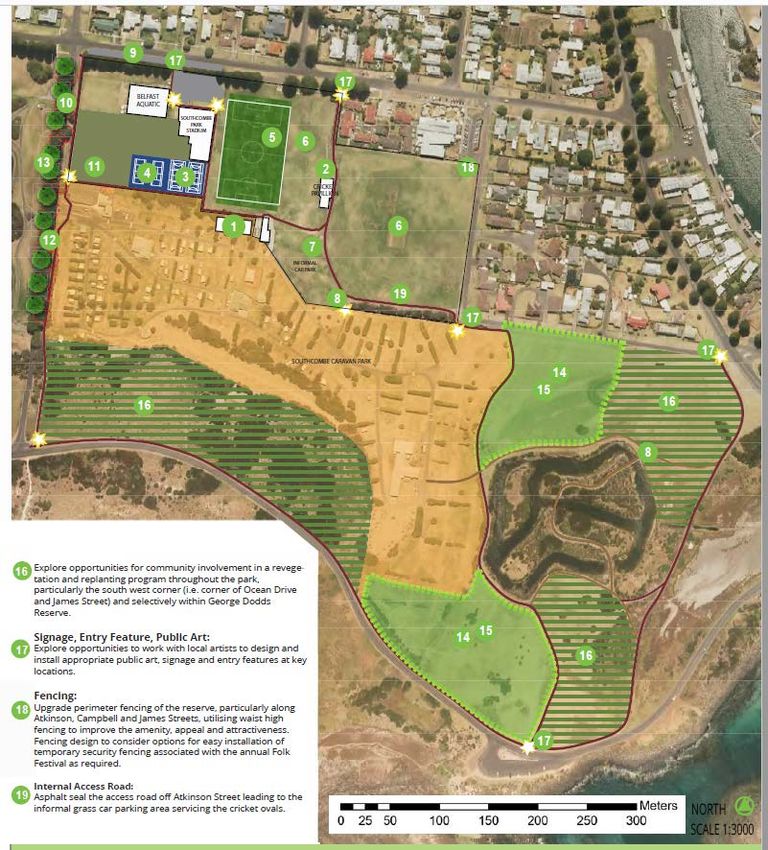
2

                                                                                                                                                                                        8

                                                                                                 1   Opportunities and Constraints

Bank Street includes a reversing space behind the angled parking which is often
used by cyclists. However this space does not meet current standards and does not
provide sufficient separation between vehicles and cyclists.

                                                                                                                                                                                                                                            13
                                                                                                                                                                                9                             14
                                                                                                                                                                                                                          7

                                                                                                                                                T
                                                                                                                                                                                                                              14

                                                                                                                                             AF
                                                                                                                                                                                                                                       14
                                                                                                                                                                                                          6
                                                                                                                                                                                                                      1
                                                                                                                                                                            8                                                                    11

                                                                                                                                                                        9                   14

                                                                                                                                          DR
                                                                                                                                                                                                                          6

                                                                                                                                                                                                                                       10

                                                                                                                                                                                                     12
Gipps Street provides a key north-south route for cyclists however there are currently
no bike lanes to provide separation.

                                                                                                                                                                                                                                                           4

                                                                                                                                                                                                 3            5
                                                                                                                                                      3
                                                                                                                                                                                    5

                                                                                                                                                                                                                                   5

The shared path along the Princes Highway is an important link and provides              Figure 8.   Existing Bicycle Infrastructure & Destinations
separation from high traffic volumes. However the shared path is not continuous
along the Highway.

Tract                                                                                    321-0154-00-U-01-RP01_Port Fairy Bicycle Implementation Plan Strategy Report                                                                  06 September 2021       09 / 15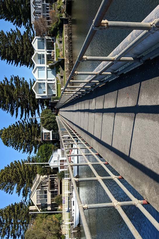
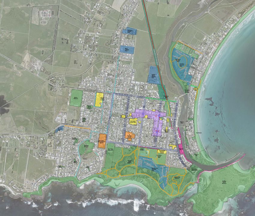
4       The Bicycle Implementation Strategy

 4.1     Overview

 This section outlines the proposed Bicycle Implementation
 Strategy for Port Fairy.
 It proposes a number of projects across the township, which
 could be considered for implementation over the short, medium
 and longer term. There are also a number of future links
 which are intended to be delivered through future residential
 development.
 The projects have not been prioritised for implementation
 however Section 5 outlines a range of criteria that will be used
 to assess the implementation priority of the projects.
 Some of the key projects shown on Figure 9 include:                  Examples of bike lanes that could be utilised where angled parking exists in Port     Examples of raised platform crossings that could be provided along Ocean Drive
                                                                      Fairy.                                                                                and other locations.
1·  Providing bike lanes along key town centre streets including
    Bank Street, Sackville Street and Cox Street to provide safer
    bicycle access into and through the shopping strips.
 2· Bike lanes along Gipps Street providing a key north-south

                                                                                                                              T
    link and connecting into the Rail Trail and coastal trail along
    Ocean Drive.

                                                                                                                           AF
 3· Providing sharrow treatments through roundabouts within the
    town centre to provide greater priority and awareness of
    cyclists.
 4· Provision of an underpass at the Princes Highway along the

                                                                                                                        DR
    Rail Trail to allow for a continuous journey along Rail Trail
    and resolve safety issues in crossing the Highway.
 5· Extension of the coastal trail to the west within the coastal
    reserve along Ocean Drive and around Martins Point.
 6· Providing a number of raised platform crossings along
    Ocean Drive to provide safe access from the coastal trail to
    key beach access points and viewing locations.                    Examples of sharrow treatments that could be utlised on roundabouts within the town   Example of a shared path and signage in Port Fairy that could be used across the
                                                                      centre                                                                                township.
 7· Providing a shared path along the southern side of
    Campbell Street connecting the school, sports and
    recreation facilities, other community facilities and open
    space at Martins Point.
 8· Providing a shared path along James Street connecting the
    coastal trail and southern open space to the town centre
    and further through to Regent Street and the Rail Trail.
 9· A continuous shared path along the Princes Highway
    connecting existing residents and accommodation into the
    town centre
10· A potential boardwalk / promenade along the waterfront
    parallel to Griffiths Street for walkers and cyclists and
    providing a major tourist attraction for Port Fairy.
11· ‘Future Links’ identified in the Port Fairy Structure Plan that
    could be delivered through future growth.

 Tract                                                                321-0154-00-U-01-RP01_Port Fairy Bicycle Implementation Plan Strategy Report                                                                                             06 September 2021   10 / 15
4
9
AY
HW
IG
SH
CE
IN
PR
NORFOLK
PL AC E
9
RIT
CH
IE S
TRE
ET
R A IL TR
ET
A IL
TRE
SS
ITH
IFF
GR
11
LA NE
GH WAY
OSMON DS
PRIN CES HI
HUG
H ES
T
AVE
HA MILTON
-P ORT FA IRY
ROAD
AF
REGE NT ST
RE ET
RE ET
STRE ET
EET
ALBE RT ST
RE ET
EA RL STREET
GR ANT STR
W ILLIA MS
JA MES ST
10
3
DR
STRE ET
BA NK STRE
ET 1 3
RE ET
GRIFFITH S STRE ET
COLLEGE
VI LLI ERS ST
RE ET
2
EET
ST
STREET
PRI NC ES STR
SACK VI LLE
PRIN CES HI
GH WAY 8
BA RC LAY
COX STRE
ET 1
RE ET
GIPPS
STREET
POLDIN G
STRE ET
ALBE RT ST
EET
3
CORBETT
S TRE E
UN ION STR
RE ET
STREET
T
OREILLY ST
WISH ART
CA MPBEL
L STRE ET
7
RE ET
PH ILLIP ST
ST
7
STRE ET
UGH BY
W ILLO
11
ATKI NSON
RE ET
ET
JA MES ST
S TRE
LING
VICTORIA
STRE ET 5
P OW
IV E
OC EA N DR
6
5 IV
E
DR
N
C EA
O
6
Figure 9. Port Fairy Bicycle Implementation Strategy
Tract 321-0154-00-U-01-RP01_Port Fairy Bicycle Implementation Plan Strategy Report 06 September 2021 11 / 154.2 Proposed Bicycle Links Project ID Name Type Address Overview Length Width Area Surface
External
Stakeholders
On-Road bike lanes to continue along Regent Street. New kerb and
BL-01 Regent Street Bike Lanes On-Road Bike Lane Regent Street between Albert Street and James Street 908.1
channel required as part of works
Table 1 provides details on the Proposed Bicycle Links BL-02 Regent Street Bike Lanes On-Road Bike Lane Regent Street between College Street and Albert Street
On-Road bike lanes to continue up to Moyne Health Care. New kerb and
channel required
455.7 VicRoads
identified in Figure 9. BL-03 Bank Street Bike Lanes On-Road Bike Lane Bank Street between Princes Highway and Gipps Street
On-road bike lanes provided through narrowing vehicle lanes and with
1572.6
suitable buffer to parking
On-road bike lanes within existing road pavement. New kerb and channel
BL-04 Gipps Street Bike Lanes On-Road Bike Lane Gipps Street between Regent Street and Lions Park 1922.1
required as part of works
On-road bike lanes provided through narrowing vehicle lanes and with
BL-05 Cox Street East Bike Lanes On-Road Bike Lane Cox Street between Sackville Street and Gipps Street 471
suitable buffer to parking
On-road bike lanes provided through narrowing vehicle lanes and with
BL-06 Sackville Street Bike Lanes On-Road Bike Lane Sackville Street between Cox Street and Bank Street 378.8
suitable buffer to parking
Potential boardwalk / promenade hanging over water to continue existing
BW-01 Griffiths Street Boardwalk / Promenade Shared Path - Boardwalk / Promenade Along Moyne River on Griffiths st 482.1 3 1446.3 Timber
wharf on west side of river
Future Link - Delivered through Link identified in the Port Fairy Structure Plan. Delivered through future
FL-01 Reedy Creek Trail Reedy Creek 2296.9
Residential Development development
Future Link - Delivered through Link identified in the Port Fairy Structure Plan. Would be delivered to
FL-02 Phillip Street Link Phillip Street 763.8
Residential Development support future growth.
Princes Highway between McGill Court and Port Fairy Holiday
FW-01 Princes Highway Shared Path Shared Path - Footpath Widening Widen existing footpath from 1.5m to 2.0m to create shared path 339.1 0.5 169.6 Concrete VicRoads
Park
FW-03 Villiers Street Shared Path Shared Path - Footpath Widening Villiers Street between Cox Street and Polding Street Widen existing footpath from 1.6m to 2.0m to create shared path 97.8 0.4 39.1 Concrete
FW-04 Cox Street Shared Path Shared Path - Footpath Widening Cox Street between Albert Street and Belfast Close Widen existing footpath from 1.3m to 2.0m to create shared path 137.4 0.7 96.2 Concrete
Widen existing path from 1.3m to 2.0m to provide shared path to Catholic
FW-05 William Street Shared Path Shared Path - Footpath Widening William Street between Cox and Campbell Street 203.5 0.7 142.5 Concrete
Primary School
New shared path connecting from Bank Street through to Regen Street and
MP-01 Rail Precinct MP Shared Path Shared Path - New from Masterplan Rail Precinct 211.5 2 423 Concrete
Rail Trail
MP-02 Southcombe Park MP Shared Path Shared Path - New from Masterplan Southcombe Park New shared paths connecting destinations within Southcombe Park 1143.4 2 2286.8 Concrete
MP-03 Gardens Reserve MP Shared Paths Shared Path - New from Masterplan Gardens Reserve New shared paths connecting through the reserve 1681.9 2 3363.8 Concrete
SP-01 Princes Highway Shared Path Shared Path - New Princes Highway between McGill Court and Rail Trail New shared path along Princes Highway connecting to the Rail Trail 578.8 2 1157.6 Concrete
New shared path connecting the Future Shared Path along Princes Hwy to
T
SP-02 Princes Hwy to Rail Trail Link Shared Path - New Along easement between Princes Highway and Rail Trail 388.9 2.5 972.3
Rail Trail along easement
SP-03 James Street Shared Path Shared Path - New James Street between Bank Street and Regent Street New shared path connecting Regent Street to the town centre 202.5 2.5 506.3 Concrete
AF
SP-03 James Street Shared Path Shared Path - New James Street between Campbell Street and Cox Street Widen existing footpath from 1.3m to 2.0m to create shared path 405.2 2.5 1013 Concrete
New shared path filling missing gap along northern end of Sackville Street -
SP-04 Sackville Street Shared Path Shared Path - New Northern end of Sackville Street 36.4 2 72.8 Concrete
Topographic challenges
Provide a 2.5m wide shared path on both sides of the bridge when it is
SP-05 Gipps Street Bridge Shared Path - New Gipps Street Bridge between Regent Street and Griffiths Street 264.7 2.5 661.8 Concrete
redeveloped
SP-07 Cox Street Shared Path Shared Path - New Cox Street between College Street and OReilly Street New shared path to fill missing link 221.4 2 442.8 Concrete VicRoads
SP-08 Cox Street Shared Path Shared Path - New Cox Street between Villiers Street and Albert Street New shared path to fill missing link 113.5 2 227 Concrete VicRoads
DR
SP-09 Polding Street Shared Path Shared Path - New Polding Street between Oreilly Street and School Crossing New shared path to fill missing link to school crossing 63.6 2 127.2 Concrete
SP-10 Avery Street Shared path Shared Path - New Avery Street between Powling Street and Oreilly Street New shared path connecting from Powling Street to the Primary School 148.6 2 297.2 Concrete
SP-11 Campbell Street Shared Path Shared Path - New Campbell Street between the Primary School and James Street New shared path connecting James Street to Primary Schools 541.5 2 1083 Concrete
SP-12 Campbell Street Shared Path Shared Path - New Campbell Street along community centre frontage Widen existing footpath from 1.5m to 2.0m to create shared path 114.1 2 228.2 Concrete
New shared path connecting to future shared path proposed as part of
SP-13 Victoria Street Shared Path Shared Path - New Victoria Street between Atkinson Street and Gipps Street 223.5 2 447 Concrete
Southcombe MP
New shared path through Martins Point connecting to coastal trail and
SP-14 Martins Point Shared Path Shared Path - New Martins Point 512.9 2.5 1282.3 Concrete
Gipps St
SP-15 Southcombe Beach Access Shared Path - New Southcombe Beach car park Provide connection from Ocean Drive to lookout at Southcombe Beach 50.3 2 100.6
Shared path largely on ocean side because of minimal disruption by
SP-16 Ocean Drive Shared Path Shared Path - New Ocean Drive between Mills Crescent and Powling Street 365.7 2.5 914.3 Concrete
driveway crossovers
Shared on ocean side because of minimal disruption by driveway
SP-17 Ocean Drive Shared Path Shared Path - New Ocean Drive between Powling Street and Anna Catherine Drive 619.4 2.5 1548.5 Concrete
crossovers
SP-18 Griffiths Street Shared Path Shared Path - New Griffiths Street between footbridge and Boat Ramp New shared path within parkland connecting from footbridge to boat ramp 211.9 2 423.8 Concrete
SP-19 Princes Highway West Shared Path Shared Path - New Princes Highway between Phillip Street and Thistle Place New shared path connecting low density residential area into town 382.1 2 764.2 Concrete VicRoads
Existing path is 1.9m and could support shared use. Needs to be cleared as
SP-20 Griffiths Street Shared Path Shared Path - New Griffiths Street between 64 Griffiths Street and Footbridge 116.4 2 232.8 Concrete
grass covering path
SP-21 Lydia Place Shared Path Shared Path - New Lydia Place New shared path connecting Griffiths Street to coastal trail 73.2 2 146.4 Concrete
Widening will be challenging as path is elevated above road. May need to
SP-22 Griffiths Street Shared path Shared Path - New Griffiths Street between Lydia Place and Moyne Court 165.8 2 331.6 Concrete
be lowered and replaced
SP-23 Griffiths Street Shared Path Shared Path - New Griffiths St along Gardens Caravan Park frontage New shared path to fill missing link along Caravan Park frontage 83.9 2 167.8 Concrete
SP-24 Griffiths Street Shared Path Shared Path - New From Richie St to north Griffiths St Shared Path along Griffiths Street providing access for existing residents 633.4 2 1266.8 Concrete
New shared path connecting existing shared path to one-way Beach Street
SP-25 Beach Street Shared Path Shared Path - New Beach Street between public toilets and Bourne Avenue 144 2 288 Concrete
access
SU-01 Griffiths Street Shared Path Shared Path - Upgrade Griffiths Street between Lydia Place and 64 Griffiths Street Existing path is in poor condition and would require resurfacing 215.9
SU-02 Ocean Drive Shared Path Shared Path - Upgrade Existing shared trail along coastal reserve on ocean Drive Uneven path surface requiring upgrade - gravel or sealed path 299.5
SZ-01 Albert Street laneway Shared Zone - Signage Albert Street between Cox Street and existing footpath Signage to identify lane as a shared bike and vehicle zone 119 VicRoads
Laneway along Griffiths Street between Boat Ramp and Battery Provide signage to denote the laneway as a shared cycling and vehicle
SZ-02 Griffiths Street Shared Zone Shared Zone - Signage 220.5
Lane zone. Could include sharrows
SZ-03 Lydia Place Shared Zone Shared Zone - Signage Lydia Place Provide signage to denote shared bike and vehicle zone 25.8
Table 1. Proposed Bicycle Links - Project Details
Tract 321-0154-00-U-01-RP01_Port Fairy Bicycle Implementation Plan Strategy Report 06 September 2021 12 / 154.3 Proposed Cycling Safety Improvements Project ID Project Name Type Address Overview
New Ramp adjacent to stairs to allow cyclists to wheel bikes up
External Stakeholders
BR-01 Footbridge Bike Ramp Bike Ramp Western end of footbridge
and down
Sackville and Bank Street Roundabout Intersection of Sackville Street and Provide sharrow treatment to provide greater awareness and
RB-01 Roundabout Improvement
Improvement Bank Street safety for cyclists
Table 2 provides details on the Proposed Cycling Safety Sackville and Bank Street Roundabout Intersection of Sackville Street and Provide sharrow treatment to provide greater awareness and
RB-01 Roundabout Improvement
Improvements identified in Figure 9. Improvement Bank Street safety for cyclists
Sackville and Cox Street Roundabout Intersection of Sackville Street and Provide sharrow treatment to provide greater awareness and
RB-02 Roundabout Improvement
Improvement Cox Street safety for cyclists
RP-01 Regent Street - Rail Trail Crossing Raised Platform Crossing Regent Street at Rail Trail crossing Provide raised platform crossing to prioritise rail trail
James Street near Southcombe
RP-02 James Street Raised Crossing Raised Platform Crossing Provide raised platform crossing to prioritise future shared path
Caravan Park entrance
James Street at Ocean Drive Provide raised platform crossing to prioritise existing shared
RP-03 James Street Raised Crossing Raised Platform Crossing
intersection path - consider full raised int.
Provide raised platform crossing to prioritise existing & future
RP-04 Ocean Drive Raised Crossing Raised Platform Crossing Ocean Drive
shared path
Provide raised platform crossing to prioritise existing shared
RP-05 Ocean Drive Raised Crossing Raised Platform Crossing Ocean Drive
path
Provide raised platform crossing to prioritise existing shared
RP-06 Ocean Drive Raised Crossing Raised Platform Crossing Ocean Drive
path
Provide raised platform crossing to prioritise existing shared
RP-07 Ocean Drive Raised Crossing Raised Platform Crossing Ocean Drive
path
Provide raised platform crossing to prioritise existing shared
RP-08 Ocean Drive Raised Crossing Raised Platform Crossing Ocean Drive
path
Mills Crescent at Ocean Drive Provide raised platform crossing to prioritise existing shared
RP-09 Mills Crescent Raised Crossing Raised Platform Crossing
intersection path
Provide raised platform crossing to prioritise existing shared
RP-10 Ocean Drive Raised Crossing Raised Platform Crossing Ocean Drive
path
Provide raised platform crossing to prioritise existing shared
RP-11 Ocean Drive Raised Crossing Raised Platform Crossing Ocean Drive at Powling Street
path
T
Provide raised platform crossing to prioritise shared path and
RP-12 Villiers Street Raised Crossing Raised Platform Crossing Villiers Street and Polding Street
enhance school safety
Intersection of Regent Street and Consider signalisation with bike priority to promote / enhance
SC-01
AF
Regent Street - Princes Highway Crossing Safety Crossing VicRoads
Princes Highway east west movements
Intersection of Villiers Street and Provide for safe north-south crossing of Cox Street - Solution to
SC-02 Villiers Street - Cox Street Crossing Safety Crossing VicRoads
Cox Street be determined
Cox Street and James Street Provide for a cyclist priority treatment across Cox Street to
SC-03 Cox Street Crossing Safety Crossing
intersection ensure safe crossing
Intersection of Griffiths Street and Provide for safe north-south crossing of Gipps Street - Solution
SC-04 Griffiths Street - Gipps Street Crossing Safety Crossing
DR
Gipps Street to be determined as part of bridge
New underpass to remove at grade crossing of the Princes
UP-01 Rail Trail Underpass Underpass Rail Trail and Princes Highway VicRoads
Hway
Table 2. Proposed Cycling Safety Improvements -Project Details
4.4 Proposed Bicycle Parking and Repair Facilities Project ID Name Type Address Overview
Bike parking to support cyclist visitors to the
BP-01 Battery Hill Bike Parking Bike Parking Battery Hill Park
park
Bike parking to support cyclist visitors to the
Table 3 provides details on the Proposed Bicycle Parking and BP-02 Apex Park Bike Parking Bike Parking Apex Park
park
Repair Facilities identified in Figure 9. BP-03 East Beach SLSC Bike Parking Bike Parking East Beach SLSC
Bike parking to support cyclist visitors to the
beach
Bike parking to support cyclist visitors to the
BP-04 Pea Soup Bike Parking Bike Parking Pea Soup
beach
Bike Parking and Bike parking and repair facilities at key
BR-01 Southcombe Beach Bike Parking Car park at Southcombe Beach
Repair Facility destination point
Table 3. Proposed Bicycle Parking and Repair Facilities - Project Details
Tract 321-0154-00-U-01-RP01_Port Fairy Bicycle Implementation Plan Strategy Report 06 September 2021 13 / 155 Criteria for Implementation Priority
The table opposite outlines the criteria that will be used to CRITERIA CATEGORIES CRITERIA QUESTIONS
assess the implementation priority of each project outlined in
Section 4. Will the project:
The criteria are organised under a number of categories with CONNECTIVITY · Connect to key destinations (i.e. schools, shops, open space, community facilities, public transport stops)?
questions that will need to answered to assess the priority of · Connect into existing bike lanes and shared path networks?
each project. · Provide a missing link in the strategic network?
Will the project:
SAFETY · Separate cyclists from roads carrying fast moving vehicles / high volumes of vehicles / heavy vehicles?
· Improve safety at a known cyclist and vehicle conflict points or crash locations?
Will the project:
T
COMMUNITY BENEFIT · Be heavily used relative to the existing and future populations?
· Cater to a range of users with varying abilities and levels of confidence?
AF
Will the project:
· Connect to key tourism destinations?
USER EXPERIENCE / TOURISM &
DR
ECONOMIC VALUE · Create a unique, local journey that will attract visitors?
· Showcase local landscape features?
· Contribute to diversifying Port Fairy’s tourism offerings?
Will the project:
· Present any potential impacts on the local landscape or environment?
TECHNICAL FEASIBILITY · Present any potential impacts on culturally sensitive areas?
· Be difficult to construct?
· Take advantage of any existing supporting infrastructure?
· Require access to private land?
Will the project:
EXTERNAL STRATEGIC SUPPORT
& POTENTIAL FUNDING · Have strategic support from external organisations? (i.e. VicRoads, Heritage Victoria)
OPPORTUNITIES · Have committed funding from external sources?
· Have strong potential to attract funding from external sources?
· Implementation cost of project
· Ongoing maintenance cost of infrastructure
COST
· Cost of land acquisition or negotiated public access
· Cost vs. benefit - Overall cost weighted against other criterion
Tract 321-0154-00-U-01-RP01_Port Fairy Bicycle Implementation Plan Strategy Report 06 September 2021 14 / 15T
AF
DR
Contact Tract
Melbourne
Level 6, 6 Riverside Quay, Southbank
VIC, Australia 3006
(03) 9429 6133
melbourne@tract.net.au
Tract 321-0154-00-U-01-RP01_Port Fairy Bicycle Implementation Plan Strategy Report 06 September 2021 15 / 15
www.tract.com.auYou can also read