TECHNICAL NOTE - The City of Port Phillip
←
→
Page content transcription
If your browser does not render page correctly, please read the page content below

TECHNICAL NOTE

To        City of Port Phillip                                  Date         14 January 2021
From      C. Munro                                              Project No. 0176
Subject Comparative Assessment of Park Street Bike Link

Executive Summary
The Park Street Bike Link between Moray Street and St Kilda Road has been committed for
construction by the City of Port Phillip and Victorian Government. This report was
commissioned by the City of Port Phillip to provide an independent review of the merit of the
link, considering both the merits of the link within the current cycling network and in
conjunction with other committed network improvements such as the Shrine to Sea cycling
corridor and St Kilda Road as well as anticipated future land use developments.

The assessment leveraged off all available data sources and our understanding of likely land
use developments and foreseeable travel patterns in around 2030. The key conclusions from
this assessment are that:

     1. The Park Street Bike Link best meets the dominant use case of local transport riding
        trips for commuting to work, shopping and other activities along an arc running from
        Fishermans Bend, Port Melbourne, South Melbourne through to South Yarra.
             o   There is no direct public transport servicing these movements, and private car
                 use is limited by congestion and parking constraints.
             o   The demand for travel along this arc is likely to increase with background
                 population growth, the development of the Domain and Fishermans Bend
                 precincts and the opening of Anzac station as part of Melbourne Metro.
     2. There are only three alternative east-west cycling corridors between Moray Street and
        St Kilda Road which could conceivably serve as alternatives to Park Street (Dorcas
        Street – Sturt Street – Coventry Street, Albert Road and Albert Road – Mac Robertson
        Girls School – Kingsway).
             o   The northern (Dorcas Street – Sturt Street – Coventry Street) and southern
                 (Albert Road – Mac Robertson Girls School – Kingsway) corridors have
                 severe constructability issues which would make them prohibitively expensive
                 to develop to a satisfactory standard, both in financial terms and in their
                 impact on other transport modes.
             o   The Albert Road corridor, which is committed for improvement as part of the
                 Shrine to Sea project, serves different travel movements to Park Street.
                 Moreover, these improvements are unlikely to significantly impact route
                 choices between Moray Street and St Kilda Road beyond the shared path that
                 already exists.
     3. The Park Street Bike Link is likely to have net community benefits if it attracts at least
        130 new riding trips/day above current levels of around 370 trips/day.

                                               Page 1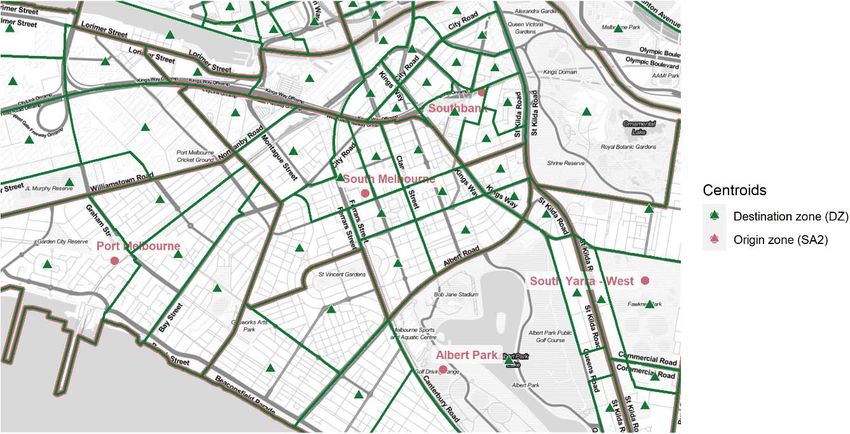
City of Port Phillip
Comparative Assessment of Park Street Bike Link
14 January 2021
1. Introduction
The City of Port Phillip, in conjunction with the State Government, has committed to
constructing a high-quality bicycle lane along Park Street between St Kilda Road and Moray
Street over a distance of 700 m. The bicycle lane is intended to complement wider network
improvements such as:
the recently improved north-south connection along Moray Street north of Park Street,
a protected bicycle lane along St Kilda Road committed for construction by the State
Government,
the Shrine to Sea bicycle path running from Albert Road at St Kilda Road to the beach
along Kerferd Road.
The present assessment was commissioned by the council to provide an independent review
of the merit of the Park Street Bike Link. Specific issues for consideration included:
What, if any, impact the Shrine to Sea improvements along Albert Road would have on
demand and the justification for the Park Street Bike Link.
The cost-benefit of the Link considering the current estimated construction cost of
around $2m, of which $1.2m has been committed by the Victorian Government.
The assessment considers existing and likely future demand for cycling travel in an east-west
direction in an area roughly bounded by Moray Street and St Kilda Road, and from Albert
Road in the south to Citylink in the north. As Kings Way severely restricts east-west
movements the analysis was confined to consider the four corridors which could conceivably
serve this demand (Figure 1.1):
Park Street Bike Link: a protected bicycle lane extending from Moray Street to St
Kilda Road
Coventry Street: a northern route along Dorcas Street, Sturt Street and Coventry
Street
Albert Road: along Albert Road, the northern service road or the existing shared path
on the southern side of the road. It is noted at least part of the existing shared path,
and the on-road route farther west along Kerferd Road, will be improved as part of the
Shrine to Sea project.
Albert Park: the existing shared path along the southern side of Albert Road in Albert
Park, diverting to the south of Mac Robertson Girls School and then following Kings
Way at Queens Road to St Kilda Road.
Page 2
City of Port Phillip
Comparative Assessment of Park Street Bike Link
14 January 2021

Figure 1.1: Study area and key corridors

The detail design of each of these possible corridors is not considered; rather, this
comparative assessment is limited to a high-level strategic network assessment of the
justification for each corridor.

2.        Methodology
The assessment sought to leverage off whatever limited data on existing and potential rider
travel demand exists along with committed and likely future transport and land use
developments. The assessment is focussed on:
      a) identifying the most likely use cases for riding through the study area
      b) assessing the likely magnitude of this demand, and
      c) ascertain which of the four corridors is likely to best meet this demand.

                                                  Page 3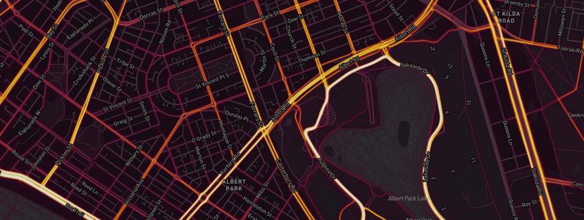
City of Port Phillip
Comparative Assessment of Park Street Bike Link
14 January 2021
The assessment is structured as follows:
Strategic context: existing network priorities in the study area.
Cycling activity: bicycle counts and Strava cycling travel in the study area to assess
current rider demand and route preferences.
Crash history: Police-recorded crash data for bicycle riders, both as an indicator of
crash risk and as a proxy indicator of existing riding activity.
Commuter travel: existing commuting travel patterns by residents of nearby suburbs
to destinations in the inner Melbourne area that are likely to traverse through the study
area.
Population, employment and school student catchments: indicators of trip
generation and attraction in each of the corridors.
Future demand: a qualitative assessment of the likely impact of committed and
proposed future developments such as the St Kilda Road bicycle lane improvements,
Anzac train station and Domain and Fishermans Bend precinct development.
Ease of delivery: likely constructability, cost and availability of land from which to
allocate space for high-quality cycling provision.
Rapid economic assessment: a rapid assessment of the likely quantum of new
cycling activity that will be required for the project to achieve a favourable benefit-cost
ratio.
Discussion and recommendations based on the above analysis as to the implications
for an improved east-west cycling connection(s) in the study area.
To assist in the overall assessment each of the four corridors is subjectively assigned a
high/medium/low rating on each of these criteria.
3. Strategic context
Three strategic planning documents that cover the study area were reviewed:
Council’s Move, Connect, Live Integrated Transport Strategy 2018-28
Council’s Domain Precinct Public Realm Masterplan
The Victorian Government’s Strategic Cycling Corridors 2018-2019.
3.1 Move, Connect, Live Integrated Transport Strategy 2018-28
Council’s Integrated Transport Strategy identifies the Park Street Bike Link as one of 15
corridors to be completed by Council or the Victorian Government. Park Street is listed as a
corridor to be completed by 2027/28. A subsequent corridor prioritisation1 commissioned by
council did not consider the Park Street Bike Link as it was assumed to be committed for
1CDM Research (2020), Integrated Transport Strategy: Bike Corridor Prioritisation, prepared for City of
Port Phillip.
Page 4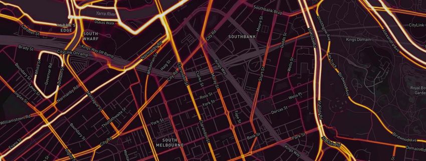
City of Port Phillip
Comparative Assessment of Park Street Bike Link
14 January 2021
construction (along with the Moray Street Bike Link, Shrine to Sea and Garden City off-road
connection to the Sandridge Trail).
3.2 Domain Precinct Public Realm Masterplan
The Domain Precinct Public Realm Masterplan makes extensive reference to Park Street and
the bike link:
It notes that Rail Projects Victoria has committed to extending the tram line along Park
Street west of Kings Way to Heather Street.
That the community consultation indicated support for a protected separated bike lane
along Park Street, but this was moderated by concern about the loss of car parking
and footpath width.
That the Victorian Government has committed funding of $1.2 m to deliver the bike
connection along Park Street.
The masterplan provides conceptual plans and cross-sections of a bike lane positioned
between kerbside parking and the general-purpose traffic lane west of Kings Way and a
kerbside protected bike lane with no on-street parking east of Kings Way.2
3.3 Strategic cycling corridors
Strategic cycling corridors (SCCs) are key transport cycling links identified by the State
Government in collaboration with local councils. Both Park Street and Dorcas Street are
designated as primary routes (C1) in the 2018-2019 update (Figure 3.1), while Albert Road is
designated as a main route (C2). Bicycle riders travelling east-west would be serviced by
Dorcas Street, Park Street and Albert Road.
2The ordinary council meeting of 18 September 2019 resolved that council would consider the feasibility
of providing a protected bicycle lane along the full length from Moray Street to St Kilda Road. It is
understood this full protection is now the preferred option for the corridor.
Page 5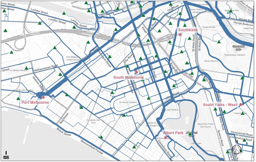
City of Port Phillip
Comparative Assessment of Park Street Bike Link
14 January 2021
Figure 3.1: Strategic cycling corridors in the study area (source: Department of Transport)
No documentation outlining the rationale for this route selection is available. However, it is
noted that:
The Dorcas Street crossing of Kings Way is currently unsignalised and restricted to
left-in, left-out movements on both approaches. It would be prohibitively expensive to
signalise this intersection and difficult to justify doing so given the traffic demands on
Kings Way and proximity to other signalised intersections. Given this formidable
constraint it is assumed in this assessment that a direct connection along Dorcas
Street is unviable.
The Park Street route diverts north along Moray Street and then west along Dorcas
Street. In practice riders travelling west are more likely to continue along Park Street
rather than turn right onto Moray Street and then left onto Dorcas Street. Doing so is
likely to be quicker and less onerous than making two unnecessary turns and there is
no strong benefit of riding on Dorcas Street above Park Street.3 Significantly
3While Dorcas Street has a solid edgeline and 1 m shoulder to angled parking that could be
misconstrued as a bicycle lane it is not marked or designated as such, and it would be unsafe for riders
Page 6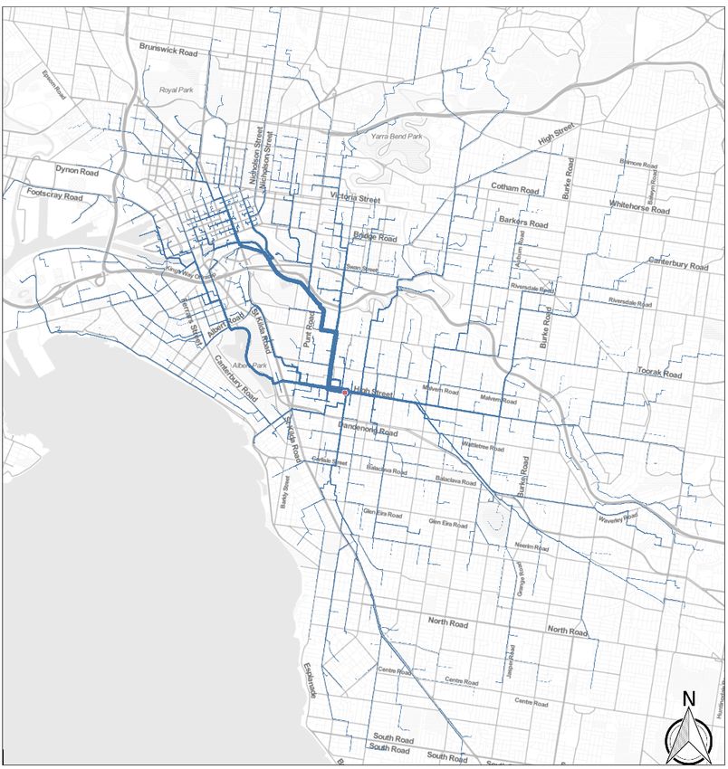
City of Port Phillip
Comparative Assessment of Park Street Bike Link
14 January 2021
improving the riding quality on either corridor would almost certainly require a
significant loss of parking.
A sealed asphalt shared path currently exists along the south side of Albert Road
extending from MSAC to the Mac Robertson Girls School car park, which then splits
into paths to the northeast to the Kings Way / Albert Road intersection and east behind
the school to the Kings Way / Queens Road intersection.
3.4 Assessment
The Park Street Bike Link is referred to in all the relevant strategic planning documents, while
the Albert Road route is referred to in the Move, Connect, Live Integrated Transport Strategy
as part of the Shrine to Sea corridor. Clearly, the Park Street corridor most closely aligns with
existing strategies from both council and the Victorian Government.
Table 3.1: Strategic assessment
Corridor Strategies Assessment
Park St Move, Connect, Live ITS High
Strategic Cycling Corridor
Coventry St ̶ Low
Albert Rd Move, Connect, Live ITS Medium
Albert Park ̶ Low
4. Cycling activity
There is extremely limited data available on travel at a local level by any mode, and this is
especially true for cycling. The most comprehensive dataset on commuting travel is
conducted only infrequently and in mid-winter (i.e. the census every five years, and for one
weekday in August) and the sample size of the all-purpose VISTA4 travel diary dataset is
insufficient to support local analysis.
Cyclist counts are limited to five sites in or near the study area based on one weekday in 2019
as shown in Figure 4.1. These counts suggest that Albert Road has the highest existing
to be positioned immediately behind angled parking. It is speculated that less confident riders may not
perceive much difference in riding comfort between the two routes: Dorcas Street offers has lower traffic
volumes than Park Street but has a single carriageway and angled parking (as opposed to parallel
parking on Park Street). This situation may change however as council has identified Dorcas Street for
improvement in the Integrated Transport Strategy. If an upgrade is provided along Dorcas Street this
may affect rider route preferences, particularly for less confident riders.
4 Victorian Integrated Survey of Travel and Activity: https://transport.vic.gov.au/about/data-and-
research/vista.
Page 7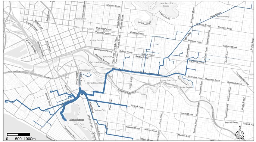
City of Port Phillip
Comparative Assessment of Park Street Bike Link
14 January 2021

demand, followed by Park Street with around twice the riding activity of Dorcas Street. The
Albert Road count corresponds to riders turning left or right onto St Kilda Road.

Figure 4.1: Cyclist counts (Tuesday 5 March 2019 7 am - 7 pm, source: City of Port Phillip)

Another means of estimating cycling activity is to use Strava. 5 This data is highly skewed
towards sport cyclists and is very unlikely to be representative of the wider riding population.
The cycling movements obtained using the Strava dataset are shown in Figure 4.2 and are
consistent with the counts insofar as they suggest Albert Road is the busiest east-west
corridor, followed by Park Street and that Coventry Street has little current riding activity. It is
also notable that there is a significant riding movement from Park Street onto Sturt Street and
then Southbank Boulevard to the eastern side of the CBD.

5   https://www.strava.com/heatmap

                                                   Page 8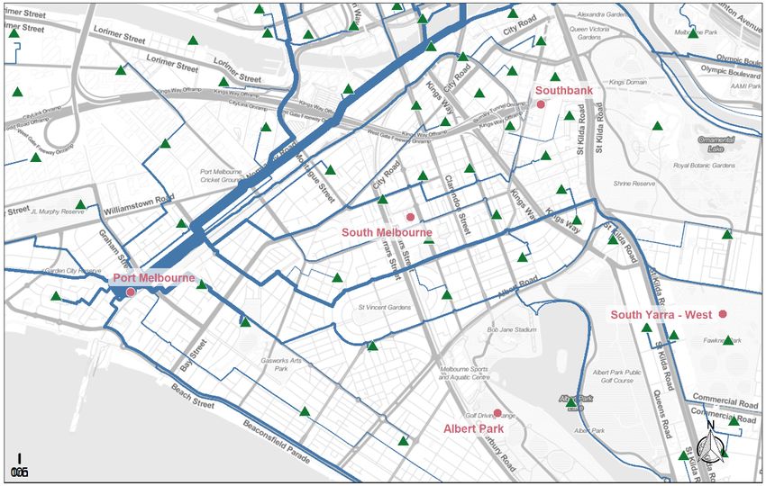
City of Port Phillip
Comparative Assessment of Park Street Bike Link
14 January 2021

Figure 4.2: Cycling activity heatmap (source: Strava, https://strava.com/heatmap)

Overall, the two cycling data sources suggest Park Street and Albert Road have the highest
existing ridership, with modest movements through Albert Park behind Mac Robertson Girls
School. A further insight from this data is to note that at least some riders are choosing to use
Park Street (in the absence of any bicycle lane) despite the presence of the shared path
alongside Albert Road. It is assumed that these riders are choosing to do so because Park
Street represents the most convenient route for their trip. Furthermore, it is suggested the
proposed improvements6 along Albert Road as part of the Shrine to Sea project are unlikely to
be substantial enough to encourage many riders to shift from Park Street.

6It is understood the Shrine to Sea project may provide a segregated path alongside Albert Road to
separate riders and pedestrians, and likely improvements to the path alignment and roadway crossings.
These improvements, while beneficial, are unlikely to attract riders who currently use Park Street to divert
what may be (depending on their origin and destination) an extra 400 m on their trip.

                                                   Page 9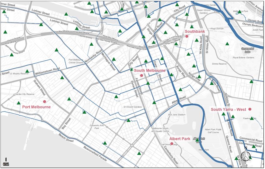
City of Port Phillip
Comparative Assessment of Park Street Bike Link
14 January 2021
Table 4.1: Existing demand assessment
Corridor Assessment
Park St High
Coventry St Low
Albert Rd High
Albert Park Medium
5. Crash history
Cyclist crash data provides an indication of both the crash frequency and the level of cycling
activity7. Police-reported crashes involving bicycle riders were extracted for a region bounding
Ferrars Street, Albert Road, St Kilda Road and Citylink and City Road between January 2010
and November 2020. Crashes that occurred on St Kilda Road or City Road are excluded, and
crashes outside the road reserve such as along the shared path in Albert Park are not included
in the Police-reported data. The crash locations are shown in Figure 5.1; there are clear crash
clusters at:
Albert Road and Ferrars Street
Albert Road and Kings Way
Moray Street and Dorcas Street
Dorcas Street and Kings Way.
Over the period of almost 11 years there were:
37 bicycle riders involved in crashes along Dorcas Street
35 along Albert Road
18 along Park Street.
Not all of these crashes involved a rider travelling along these streets – there will be some
instances where the rider is travelling along an intersecting road. Of the 18 crashes along
Park Street, two thirds (12) were on the section covered by the Bike Link (i.e. Moray Street to
St Kilda Road). Most (8) resulted in serious injuries to the rider. Three occurred at the
roundabout at Heather Street, three at Kings Way and two each at Palmerston Crescent /
Wells Street, Little Bank Street and approaching St Kilda Road.
7 Clearly, crashes are not perfectly correlated with cycling activity given that different roads have different
risks. However, there is generally a relationship between corridors with high crash frequency also having
high cycling demand.
Page 10City of Port Phillip
Comparative Assessment of Park Street Bike Link
14 January 2021
Figure 5.1: Cyclists involved in crashes (January 2010 - November 2020, crashes located at the same
location are jittered for clarity, source: VicRoads Crashstats)
In considering the impact of the four possible corridors on crash mitigation it is noted that most
of the crashes are occurring at or near intersections, and indeed almost all the remainder
involving motorists emerging from or turning into driveways or kerbside parking. Whether
these crash types will be affected by any treatment will depend on the intersection design
details, which are not yet known. Furthermore, it is assumed that at least in the case of the
Albert Road corridor and Shrine to Sea project there will be little change in cyclist route
choices so the exposure pattern will not significantly change.
Given the importance of intersection treatments and recognising that effective treatments may
be difficult to implement at the critical intersections without significant impacts on traffic
capacity, it is suggested that the none of the corridors are likely to be justified on safety
grounds.8 Moreover, it is difficult to differentiate between the corridors on the potential safety
benefit. However, on balance if Park Street were to become more attractive and to entice
riders away from higher speed, higher volume Albert Road and from Sturt Street there may be
marginal safety benefits given that Park Street likely has lower crash risk given the lower traffic
8 This is not to suggest there is no merit in investing in treatments to reduce crash likelihood, but rather
that if safety of itself were the motivation the most cost-effective approach may be to address the crash
clusters (blackspots) in isolation.
Page 11City of Port Phillip
Comparative Assessment of Park Street Bike Link
14 January 2021
speeds and volumes – hence this corridor is assessed as medium in the crash assessment in
Table 5.1
Table 5.1: Crash assessment
Corridor Assessment
Park St Medium
Coventry St Low
Albert Rd Low
Albert Park Low
6. Commuting travel
The census journey to work data provides insight into commuting journeys for an August
weekday in 2016. Origin-destination data was analysed using Statistical Area 2 (SA2) as the
home location and Destination Zone (DZ) as the workplace.9 Total commuting flows were
obtained for the four SA2 zones most likely to account for commuting outflows (i.e. South
Melbourne, Albert Park, Port Melbourne and Port Melbourne Industrial) and three that likely
contribute inflows (i.e. South Yarra – West, South Yarra – East, Prahran – Windsor). The SA2
and DZs in the study area are shown in Figure 6.1.
9 SA2s have an average population of around 10,000 people and, in the study area, broadly accord with
suburb boundaries (e.g. South Melbourne, Port Melbourne, Albert Park). Destination zones are smaller
than SA2s; in the study area there are approximately 10 destination zones for every SA2.
Page 12City of Port Phillip
Comparative Assessment of Park Street Bike Link
14 January 2021
Figure 6.1: Origin and destination zones in study area
Destination zone centroids with 10 km of the SA2 centroids based on crowfly distance were
excluded10 and the shortest path using an OpenStreetMap routing algorithm11 for bicycle riders
used to obtain likely travel paths between each origin-destination pair. A complete series of
maps for each suburb are given in Appendix A and suggest that:
The most significant commuter flow from South Melbourne is along Dorcas Street and
Moray Street into the CBD, followed by Cecil Street, Sturt Street (for trips heading east
towards Richmond), Montague Street to Docklands and Park Street to South Yarra
and southern suburbs. Most notably, there are very few trips along Coventry Street or
Albert Road.
Almost all trips from Port Melbourne would use the Sandridge Trail towards the CBD.
However, there is some movement along Park Street and modest movements along
Albert Road and Coventry Street.
Trips from Albert Park would predominantly travel up Clarendon Street and Cecil
Street towards the CBD. A modest number would use Albert Road through the study
area and almost none would use Park Street or Coventry Street.
10 It was arbitrarily assumed that very few commuting bicycle trips are likely to extend beyond 10 km.
This assumption was necessary to reduce the computation time – even with this limit there are 2,009
origin-destination pairs that require computation.
11 The Open Source Routing Machine (OSRM) using bicycle mode was used to obtain the shortest paths
(http://project-osrm.org/). Weights for intersections are defined in the default cycling file:
https://github.com/Project-OSRM/osrm-backend/blob/master/profiles/bicycle.lua. The routing algorithm
does not prioritise routes with cycling infrastructure.
Page 13City of Port Phillip
Comparative Assessment of Park Street Bike Link
14 January 2021
There are significant movements from South Yarra travelling up St Kilda Road, turning
left onto Park Street to reach destinations in South Melbourne, Port Melbourne and
Docklands.
The estimated flows from all origins in the study area are shown in Figure 6.2. Park Street and
Sturt Street are clearly the busiest routes according to this analysis. However, it is noted that
the routing algorithm does not capture the attractiveness of the current painted bicycle lane
along St Kilda Road, let alone the committed protected bicycle lane. It is plausible that a
significant proportion of the demand routed along Sturt Street in this analysis would instead
use Park Street to access St Kilda Road, especially after completion of the protected bicycle
lane along St Kilda Road. As such, if anything this analysis is likely to underrepresent the
current and future commuter potential along Park Street.
Figure 6.2: Estimated cycling commuting potential
The analysis suggests the markets for Park Street and Albert Road are distinct; that is, each
route serves different rider demands. A select link analysis12 for Park Street shown in Figure
6.3 suggests that most of the commuter cycling potential is from residences in South
Melbourne, Port Melbourne and South Yarra. By contrast, demand along Albert Road is
predominantly originating in Albert Park and travelling to the south-eastern or eastern suburbs.
12 In a select link analysis all trips that travel along a single link are selected; for example, all trips that
use Park Street immediately east of Kings Way. This analysis is useful to understand the pattern of
origins and destinations that use a link in a transport network.
Page 14City of Port Phillip
Comparative Assessment of Park Street Bike Link
14 January 2021
This reiterates the conclusion that the Park Street Bike Link and Shrine to Sea projects are
likely to be complementary rather than directly competing with one another.
Figure 6.3: Select link analysis for Park Street
Figure 6.4: Select link analysis for Albert Road corridor
In summary, this analysis suggests that:
a) There is significant orbital commuting demand along a corridor from South Yarra
through South Melbourne towards Port Melbourne and Docklands for which Park
Street would be the most direct riding route.
b) Albert Road may also attract riders, but predominantly from Albert Park. This market
is independent of the Park Street market.
Page 15City of Port Phillip
Comparative Assessment of Park Street Bike Link
14 January 2021
Given these findings we assess the Park Street corridor as having the highest commuter
cycling potential, with Albert Road having medium potential.
Table 6.1: Commuter travel assessment
Corridor Assessment
Park St High
Coventry St Low
Albert Rd Medium
Albert Park Low
7. Population, employment and school catchments
The resident population, employment and school student catchment for each of the four
corridors was obtained within a radius of 300 m of each corridor. This distance of 300 m was
arbitrarily chosen as representing:
a) A convenient, close distance someone is likely to be comfortable riding to access the
corridor.
b) The approximate distance between the corridors, such that all residences in the study
area are captured by at least one corridor.
c) The desirable network density for cycling networks of 300 – 400 m.13
Population and employment data were obtained from the ABS Census of Population and
Housing 2016 with the smallest spatial resolution available14. Both full- and part-time
employment was included. Where the zones extended across the 300 m buffer the population
or employment were apportioned based on the area covered by the buffer. School enrolment
data for February 2020 was used from the Department of Education and Training.
The catchment is illustrated in Figure 7.1. This limited analysis has major limitations; very few
riders are likely to travel entirely within the corridor, with many (if not most) travelling through
the corridors en route to elsewhere (as identified in the commuter analysis in Section 6).
Nevertheless, it provides some indication of the locally generated and attracted demand.
13 For example, the Dutch CROW Design Manual for Bicycle Traffic states that an ideal cycling network
density in urban areas is 300 – 500 m, and for a good level of service a density of 250 – 400 m is
stipulated in the London Cycling Design Standards.
14 Mesh blocks for population and Statistical Area 2 for employment.
Page 16City of Port Phillip
Comparative Assessment of Park Street Bike Link
14 January 2021
Figure 7.1: 300 m buffer around each corridor
The catchments are given in Table 7.1. The Park Street corridor has the highest population
and second highest employment, but no schools within 300 m. The Coventry Street corridor
has the second highest population, highest employment and second highest student
enrolment.15 That the Albert Road and Albert Park corridors have the lowest population and
employment catchments is unsurprising given the presence of the park.
15The Coventry Street corridor includes the Victoria College of the Arts Secondary School and Hester
Hornbrook Academy within the northern periphery of the catchment, while the Albert Road and Albert
Park corridors pass adjacent to Mac Robertson Girls School.
Page 17City of Port Phillip
Comparative Assessment of Park Street Bike Link
14 January 2021
Table 7.1: Catchment statistics within 300 m
School
Corridor Population Employment enrolments
Park Street 6,203 7,034 0
Coventry Street 5,348 8,821 537
Albert Park 4,337 5,291 989
Albert Road 4,651 5,564 989
Both Park Street and Coventry Street are assessed as having medium catchments on the
basis that while Park Street has marginally higher population and employment, Coventry
Street has (albeit at the periphery of the catchment) two schools within the 300 m catchment.
Table 7.2: Catchment assessment
Corridor Assessment
Park St Medium
Coventry St Medium
Albert Rd Low
Albert Park Low
8. Future demand
The existing travel patterns in the study area are expected to alter significantly once the
Melbourne Metro project is complete and development occurs in the Domain precinct. It is
also conceivable that the Fishermans Bend urban renewal will affect the corridor.
The Melbourne Metro Business Case16 states that:
Daily patronage of around 38,000 passengers forecast by 2031 at Anzac station, of
which just over half (55 – 57%) would interchange from/to tram and bus services.
Local population catchment of around 17,000 and 33,000 jobs within 800 m by 2031.
Fishermans Bend is anticipated to accommodate 80,000 residents and 80,000 jobs by 2050.17
16 https://metrotunnel.vic.gov.au/__data/assets/pdf_file/0020/40484/MM-Business-Case-Feb-2016-
APPENDIX-05.PDF
17 https://www.fishermansbend.vic.gov.au/__data/assets/pdf_file/0020/35093/Fishermans-Bend-
Framework.pdf
Page 18City of Port Phillip
Comparative Assessment of Park Street Bike Link
14 January 2021
It is understood that rider access to the Domain station will be good from both Park Street and
Domain Road. However, Park Street will provide a more direct connection into the South
Melbourne activity centre and towards Fishermans Bend and so may reasonably be expected
to better meet travel to and from these new developments. Coventry Street will operate
towards the periphery and so is assessed as having the least alignment with these future
developments.
Table 8.1: Future development assessment
Corridor Assessment
Park St High
Coventry St Low
Albert Rd Medium
Albert Park Low
9. Ease of delivery
Ease of delivery is one the prioritisation criteria in the Move, Connect, Live Integrated
Transport Strategy. Many of the corridors present significant challenges to delivery, either
because of limited road reservations with significant competition for space or are outside the
direct control of the City of Port Phillip. Only the Park Street corridor resides entirely within
land managed by the City of Port Phillip; Coventry Street to the north is part of the City of
Melbourne and Albert Park to the south through which the existing shared path travels is
managed by Parks Victoria. Furthermore, Albert Road (including the service lanes) and Kings
Way (including the short section between Queens Road and St Kilda Road) are declared
roads and so controlled by VicRoads.
Our high-level assessment of ease of delivery is summarised in Table 9.1. The Park Street
corridor is assessed as having the highest deliverability, primarily because:
It is entirely within Council’s jurisdiction.
There are substantial logistical and cost savings to be achieved by combining the
works with the tram extension and Metro rail works, whereas there are no major
projects planned for the other corridors aside from Albert Road near Anzac station.
The intersections of Park Street at Kings Way and St Kilda Road are less complex
than the alternative corridors.
It is noted that no consideration was given to the presence of major underground services in
this assessment, which (if present) could have a significant impact on deliverability.
Page 19City of Port Phillip
Comparative Assessment of Park Street Bike Link
14 January 2021
Table 9.1: Ease of delivery
Corridor Benefits Challenges Assessment
Park St Entirely within CoPP On‐street parking retention High
control Drainage and possible underground services
Construction cost savings Heather Street intersection is complex
associated with tram and
Metro rail works
Relative simple controlled
intersection at Kings Way
and St Kilda Road
Designated as a SCC
Coventry St Dorcas St and Sturt St are Coventry Street is managed by City of Melbourne Low
in CoPP control Unlikely to be able to take roadspace for bicycle
lane on Sturt Street
Narrow footpath on eastern side of Sturt Street;
possible loss of parkland if path widened in
Dorcas St Reserve
Not designed as a SCC
Albert Rd Shared path in Albert Park Albert Rd and service lanes are declared roads Medium
already exists Existing shared path in Albert Park managed by
Parks Victoria
Not designed as a SCC
Albert Park Shared path in Albert Park Existing shared path in Albert Park managed by Low
already exists and is Parks Victoria
generally in good Rider‐pedestrian conflict risk by declaring
condition footpath on south side of Kings Way (between
Signalised crossing at Queens Rd and St Kilda Road) a shared path
Queens Road would Challenging intersection of Kings Way at St Kilda
warrant only minor Road: all intersecting roads are declared and
improvement operate at close to saturation capacity during
peak periods. Providing additional signal phasing
time to cyclists would likely have severe impacts
on motor traffic capacity. Moreover, there is no
pedestrian crossing directly at the intersection,
leading to a circuitous route for riders and
pedestrians.
Not designed as a SCC
Page 20City of Port Phillip
Comparative Assessment of Park Street Bike Link
14 January 2021
10. Economic assessment
It is not feasible to develop reliable cyclist demand forecasts for the Park Street Bike Link.
However, the construction costs have been established at around $2m (of which the State
Government has committed $1.2m) and the economic benefits of an additional cycling
kilometre of travel is specified in ATAP M4 Active Travel18. The economic benefits of
additional cycling in the corridor extend across domains such as:
congestion (road network) and crowding (public transport)
emissions reduction
fuel cost savings
noise
safety
health.
Most economic benefit is usually obtained from reduction in crash costs (i.e. safety benefits)
and health benefits accruing both from increased physical activity. As the crash benefit will be
heavily dependent on the intersection treatments (Section 5) they cannot be estimated at this
in the absence of detail designs. Instead, it is conservatively be assumed that any treatment
along Park Street would not affect the crash rate. Rather, it is assumed the benefits would
entirely accrue from a reduction in mortality and morbidity associated with increased physical
activity among those who shift to riding, or who make additional riding trips they would not
otherwise have made in the absence of the project. ATAP provides units values for these
benefits of $0.45/km for the health benefits to the individual19 and $0.48/km for healthy system
cost savings (that is, the avoided cost to the taxpayer of not having to treat chronic disease
associated with physical inactivity). These 2013 prices and values are escalated to 2020 using
the Melbourne consumer price index (ABS 6401.03) in the case of the individual benefits and
using total health expenditure estimates from AIHW20 for Victoria, giving individual health
benefits of $0.57/km and $0.61/km for health system benefits.
The counts suggest around 370 cycling trips/weekday currently occur on Park Street. VISTA
indicates that the average inner Melbourne cycling trip is 3.9 km long, which would be
consistent with a trip from South Melbourne to South Yarra. Assume a 30-year economic life,
270 day annualisation, 7% discount rate and other assumptions as per ATAP M4. If cycling
were to increase from 370 riders/day (as measured in the 2019 count) to 450 riders/day the
net present value (NPV) of the benefits would be $1.34 m. This equates to a project benefit-
cost ratio of 0.7 using the $2 m total project cost, or 1.7 if only the $800,000 contribution from
the City of Port Phillip is considered. Repeating this process for a series of demand forecasts
18 https://www.atap.gov.au/mode-specific-guidance/active-travel/index
19 These individual benefits are after the application of rule-of-half to account for consumer surplus.
Rule-of-half does not apply to the health system costs.
20 Australian Institute of Health and Welfare (2019), Health expenditure Australia 2017-18.
https://www.aihw.gov.au/reports/health-welfare-expenditure/health-expenditure-australia-2017-18/data
Page 21City of Port Phillip
Comparative Assessment of Park Street Bike Link
14 January 2021
suggest that demand of around 500 riders/day will be required to achieve a positive BCR using
the total $2m construction cost (Table 10.1). In other words, for the investment to produce net
health benefits greater than the costs demand will need to increase by around 35% from 370
riders/day to 500 riders/day. It should be noted that this analysis excludes operating costs and
non-health benefits and costs, and that the increase in demand will need to come from new
riding trips (i.e. trips that otherwise would have been made by motorised modes or are all-new)
rather than riding trips that have diverted from other routes. In our view an increase of this
order that can be attributed21 to the project is plausible. As such, it is suggested the Park
Street Bike Link is likely to represent good value for money. This will be especially true if the
design can reduce the crash risk. On the balance of probabilities, it seems far more likely the
project will reduce crashes than have a neutral effect or even increase crashes. This will be
especially true if the project incorporates wider street calming measures which provide for a
safer pedestrian and motorist environment, in which case there should be safety benefits for all
modes.
Table 10.1: Rapid economic assessment (health benefits only)
Benefit-Cost Ratio
Forecast demand NPV ($m, Based on total cost Based on Council
(ADT, currently 370/day) 2020 values) ($2m) contrib. ($800k)
400 $0.50 0.3 0.6
450 $1.34 0.7 1.7
500 $2.18 1.1 2.7
550 $3.02 1.5 3.8
600 $3.86 1.9 4.8
21Only changes in ridership directly attributable to the project can be incorporated in the cost-benefit
analysis; increases in riding due to, for example, to the construction of Anzac station or wider land use
changes (all of which are forecast to occur irrespective of the presence of the bike link) cannot be
incorporated into the project benefits.
Page 22City of Port Phillip
Comparative Assessment of Park Street Bike Link
14 January 2021
11. Conclusion
The attributes of each of the corridors are summarised in Table 11.1. On all the criteria
assessed in this analysis the Park Street Bike Link is assessed as being equal or better than
the alternative corridors.
Table 11.1: Assessment summary
Corridor
Attribute Park St Coventry St Albert Rd Albert Park
Strategic alignment High Low Medium Low
Cycling activity High Low High Medium
Crash history Medium Low Low Low
Commuter travel High Low Medium Low
Catchment Medium Medium Low Low
Future development High Low Medium Low
Ease of delivery High Low Medium Low
The most compelling arguments in support of the Park Street Bike Link are likely to be that:
Park Street best aligns with the most likely usage; that is, for travel along an arc from
Fishermans Bend through Port Melbourne to South Melbourne and east to South
Yarra.
This primary market is distinct from that likely to be met by the Shrine to Sea project
along Albert Road, such that there is limited duplication in having both links.
The impediments to construction of the Park Street Bike Link are less than for the
Coventry Street and Albert Park options. There would be almost insurmountable
difficulties in providing a high-quality cycling connection along Sturt Street and
Coventry Street to the north or from the shared path behind Mac Robertson Girls
School across Queens Road to St Kilda Road.
In considering the merit of the Park Street Bike Link we note that:
The main use case is unlikely to be residents of South Melbourne or surrounding
suburbs commuting to the CBD; instead, these movements will continue to be served
by north-south corridors along Moray Street, Clarendon Street and Cecil Street.
Trips originating or finishing in Albert Park and Middle Park with destination in the east
are more likely to use Kerferd Road and Albert Road, or Albert Park, than Park Street.
There is already demonstrable rider demand along Park Street; these riders are
choosing not to use the shared path along Albert Road that already exists. The
proposed improvements along Albert Road as part of Shrine to Sea are unlikely to be
Page 23City of Port Phillip
Comparative Assessment of Park Street Bike Link
14 January 2021
sufficient to encourage these riders to divert to instead use Albert Road given the
longer distance and incremental nature of the improvements.
It is suggested the Park Street Bike Link is best aligned to meet local transport cycling needs
now and this will become increasingly true in the future as the Domain and Fishermans Bend
precincts develop. In our view the Park Street Bike Link has merit within the current cycling
network and will continue to do so once the Shrine to Sea project is complete given that the
routes serve different markets.
Page 24City of Port Phillip
Comparative Assessment of Park Street Bike Link
14 January 2021
Appendix A: Commuter travel maps
South Melbourne originating trips
Page 25City of Port Phillip
Comparative Assessment of Park Street Bike Link
14 January 2021
Page 26City of Port Phillip
Comparative Assessment of Park Street Bike Link
14 January 2021
Port Melbourne originating trips
Page 27City of Port Phillip
Comparative Assessment of Park Street Bike Link
14 January 2021
Albert Park originating trips
Page 28City of Port Phillip
Comparative Assessment of Park Street Bike Link
14 January 2021
South Yarra - West originating trips
Page 29City of Port Phillip
Comparative Assessment of Park Street Bike Link
14 January 2021
Prahran - Windsor originating trips
Page 30You can also read