Portsmouth and Chesapeake Joint Land Use Study - (JLUS) Hampton Roads Region Virtual Town Hall March 2, 2021
←
→
Page content transcription
If your browser does not render page correctly, please read the page content below
Hampton Roads Region
Portsmouth and
Chesapeake
Joint Land Use Study
(JLUS)

Virtual Town Hall
March 2, 2021

12:00 Welcome + Presentation
     Question and Answer
 1:00 Adjourn

                               Source: www.navy.mil / U. S. Navy photo by Photographer's Mate 2nd
                                                                           Class John L. Beeman.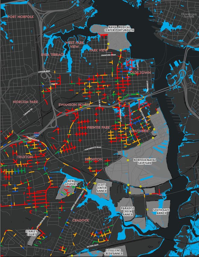
Virtual Meeting – Housekeeping!
– All participants are muted upon entry.
– If you have a question, please use the Q/A function at the bottom of
  your screen to type your question.
– For those on the phone, we do want to hear from you. We will call on you
  by using the last 4 digits of your phone number and unmuting your line. If
  you do not have a question, please say so.
– We will answer as many questions as possible.
– All questions will be compiled into an FAQ document. The FAQ will be
  posted on www.hrpdcva.gov/portsmouth-chesapeakeJLUS

– The meeting will be recorded.

2                             Portsmouth and Chesapeake JLUS
JLUS Team

 Project
 Administrator

JLUS
Partners

Project
Consultants

 3               Portsmouth and Chesapeake JLUS

What is a Joint Land Use Study?
• Collaborative process to address
                                                          The Joint Land Use Study
  compatible use issues affecting
                                                          program is part of the
  the localities and the Navy                             Military Installation
• Developed by and for the local                          Sustainability program at
  community                                               OLDCC. The program is
                                                          designed to provide
• Supported by the Department of                          technical and financial
  Defense (DoD) Office of Local                           assistance to states and
  Defense Community                                       local governments to
  Cooperation (OLDCC)                                     analyze and implement
                                                          actions necessary to foster,
                                                          protect, and enhance
                                                          military installation
                                                          sustainability.
                                                          https://www.oea.gov/our-programs/military-installation-
                                                          sustainability

4                        Portsmouth and Chesapeake JLUS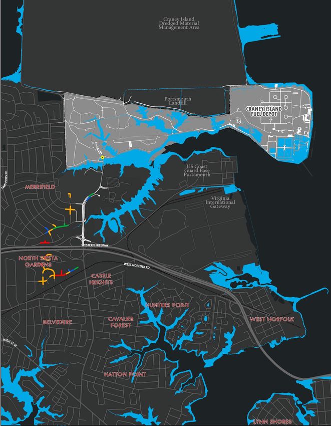
JLUS Study Area
•   Portsmouth
•   Chesapeake (north of I-64 approximate)
•   Naval Station Norfolk – Navy Supply
    Systems Command Fleet Logistics Center
    Norfolk, Craney Island Fuel Depot
•   Naval Support Activity Hampton Roads –
    Portsmouth Annex (Naval Medical Center
    Portsmouth)
•   Norfolk Naval Shipyard and associated
    properties including
    •   St. Juliens Creek Annex
    •   South Gate Annex
    •   Scott Center Annex
    •   The Village at New Gosport
    •   Stanley Court

The Hampton Roads Planning District
Commission is the primary project sponsor

5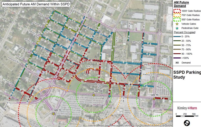
JLUS Process

6              Portsmouth and Chesapeake JLUS
Refinement of Key Issues

       Parking             Transit + Access             Roadway                    Land Use and          Coordination +
                                                        Flooding                     Utilities           Communication
Limited availability of   Transit options for      Future rainfall and        Opportunities for       Regional-level activities
parking within a          installation             tidal flooding will        more convenience,       could have the potential
reasonable walking        employees are            impact multiple            restaurants, or         to impact Navy
distance leads some       limited and bus          roadways used to           shopping near the       operations.
Shipyard employees        hours of operations,     access the                 installations exist.
to search for             routes, and transfer     installations and          However, underlying
preferable                processes are likely     sea level rise will        environmental
alternatives. This        deterrents to use.       compound                   restrictions or local
leads to overflow         Gaps in the              flooding issues            land use and zoning
parking in the            pedestrian and trail     over time.                 policies need to be
neighborhoods             networks can also                                   considered.
around the Shipyard.      discourage the use of
                          other transportation
                          modes.

  7                                               Portsmouth and Chesapeake JLUS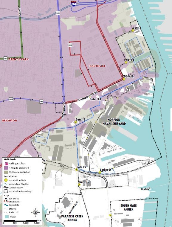
JLUS DRAFT Goals

•   Future flooding impacts to the transportation network are mitigated
•   Military installation resilience is strengthened
•   Access to Navy installations is maintained and expanded
•   Neighborhoods surrounding the installations are enhanced
•   Redevelopment and reuse of land improve the local economy
•   Policies and regulations manage growth and prevent conflicts
•   Navy and locality relationships are strengthened

8                               Portsmouth and Chesapeake JLUS
Parking
The location of parking affects behavior

                                        – Approximately 20% of NNSY
                                          parking spaces are in remote
                                          locations of the installation or
                                          outside of the installation
                                          boundaries
                                        – Parking in nearby neighborhoods
                                          is sometimes more “convenient”
                                          than options on the installation
                                        – Future mission growth could
                                          increase parking demand and
                                          decrease parking supply

10                   Portsmouth and Chesapeake JLUS
The location of parking affects behavior
• Walking from remote parking lots adds considerable time to an employee’s commute and
there is no shuttle between off-site parking lots (such as South Gate Annex or Paradise Creek
Annex) and the Shipyard.
• At NMCP, most of the garage is reserved for patients and the remainder fills up fast.
Norfolk Naval Shipyard Naval Medical Center Portsmouth
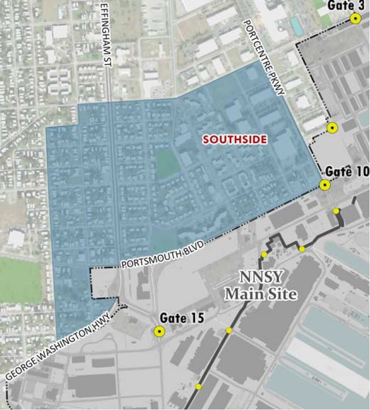
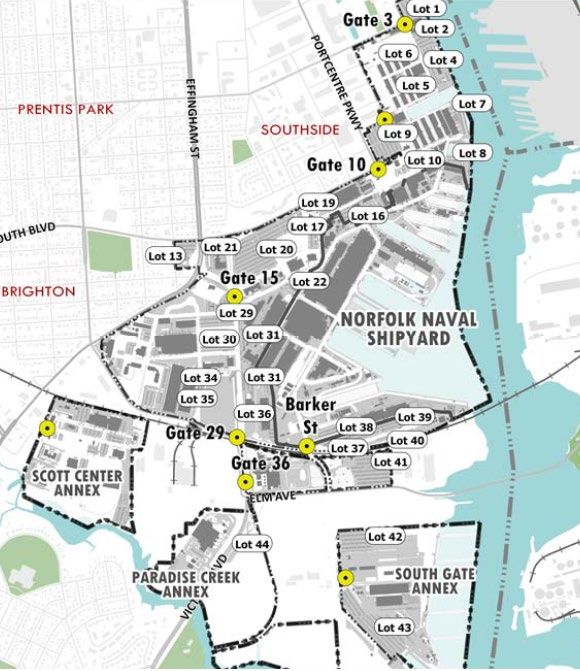
11 Portsmouth and Chesapeake JLUSParking impacts the adjacent neighborhood • The Southside Parking District next to the Shipyard regulates on street parking • Blocks closest to the Shipyard fill up first and sometimes vehicles violate posted regulations • An average of 250 shipyard employees/vehicles park in the neighborhood daily • Shipyard growth will place increased pressure on parking supply and the neighborhood 12 Portsmouth and Chesapeake JLUS
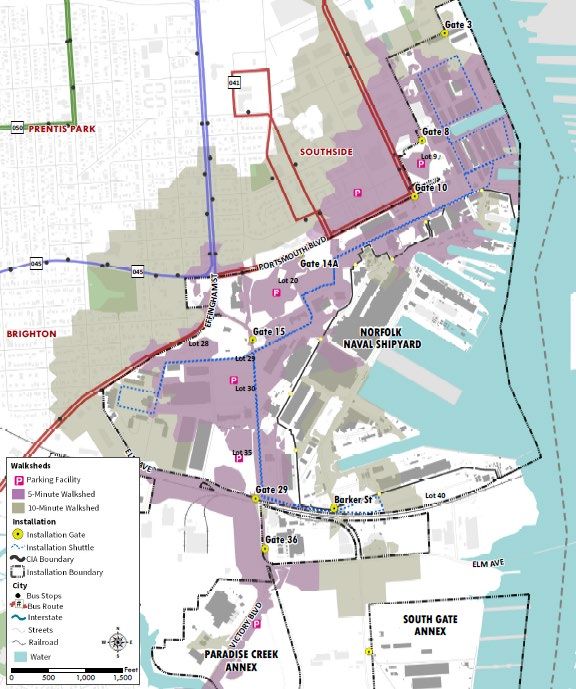
Transit and Access
There are deterrents to using transit for
           commuting to an installation
 • Shipyard and NMCP shifts times do not align with bus service operating hours.
 • Bus wait times can be long, and many routes require a transfer. Riders must also
   factor in additional walk time from a stop to the workplace.

Naval Medical Center Portsmouth   Norfolk Naval Shipyard                  St. Juliens Creek Annex

  14                                     Portsmouth and Chesapeake JLUS
Roadway Flooding 15 Portsmouth and Chesapeake JLUS
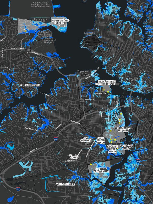
Areas Vulnerable to Flooding

– The flooding analysis for the JLUS evaluated impacts from flooding that occur on a
  relatively frequent basis, i.e., with a relatively high chance of occurring in any
  given year, as opposed to a large storm event.
– This type of flooding can reduce or block access to Navy installation gates, disrupt
  emergency response activities in and around the installation, and affect ability of
  Navy personnel to get to work.
– The flood scenarios used a combination of high tidal water levels and rainfall
  conditions and cover a range of tidal and rainfall events that would cause varying
  degrees of flooding today and in the future.

16                                Portsmouth and Chesapeake JLUS
Areas Vulnerable to Flooding
                                                            Scenario
                                                                     Description
                                                               #
     • Sea Level Rise values of 1.5 and                               Tidal Flooding with No Rainfall
       3.0 feet were based on HRPDC                              1          No Rain, No Sea Level Rise
       planning guidance                                         2          No Rain, Estimated 1.5-feet of Sea Level Rise
     • A present-day 24-hour rainfall total
                                                                 3          No Rain, Estimated 3-feet of Sea Level Rise
       was defined as 6.2 inches.
                                                                           Tidal Flooding with Current Rainfall Levels
     • A future 24-hour rainfall total was
       defined as 6.8 inches                                     4
                                                                            Current Rainfall (6.2-inches over 24 hours), No Sea
                                                                            Level Rise
                                                                            Current Rainfall (6.2-inches over 24 hours),
                                                                 5          Estimated 1.5 feet of Sea Level Rise
 – Hydrologic and hydraulic (H&H)                                           Current Rainfall (6.2-inches over 24 hours),
                                                                 6
   models were used to simulate both                                        Estimated 3 feet of Sea Level Rise

   the high river level associated with                                     Tidal Flooding with Future Rainfall Levels
   tidal flooding and the rainfall runoff                        7          Future Rainfall (6.8-inches over 24 hours), Estimated
   needed to evaluate compound                                              1.5 feet of Sea Level Rise

   flooding.                                                     88         Future Rainfall (6.8-inches over 24 hours), Estimated
                                                                            3 feet of Sea Level Rise

                                                            Note: The 1-year return period value of 2.8 feet NAVD88 is consistent with current
                                                            stormwater infrastructure design practices in the JLUS partner cities and is similar
                                                            to the minor tidal flooding level used in the Norfolk and Virginia Beach JLUS.

17                                 Portsmouth and Chesapeake JLUS
Estimated Flooding from
Sea Level Rise
(Scenarios 1, 2, 3)
– Areas along the shorelines will
be impacted the most, including
areas near the installations
– Heavily impacted areas include
• Downtown Portsmouth
• Park View
• Effingham Street
• Newtown/Southside
• East side of Brighton/Prentis Park
• Broadmoor
• Woodland Terrace
11 No Rain, No Sea Level Rise
No Rain, Estimated 1.5-
22
feet of Sea Level Rise
33 No Rain, Estimated 3-feet
18 of Sea Level RiseRoadway Flooding Near
Craney Island Fuel Depot
Scenario
#
Description
Tidal Flooding with Future Rainfall Levels
7 Future Rainfall (6.8-inches over 24 hours),
Estimated 1.5 feet of Sea Level Rise
The roadway segments
potentially affected by flooding
shown in color.
19Roadway Flooding Near
NMCP and NNSY
Scenario
#
Description
Tidal Flooding with Future Rainfall Levels
7 Future Rainfall (6.8-inches over 24 hours),
Estimated 1.5 feet of Sea Level Rise
The roadway segments
potentially affected by flooding
shown in color.
20Roadway Flooding Near
St. Juliens Creek Annex
Scenario
#
Description
Tidal Flooding with Future Rainfall Levels
7 Future Rainfall (6.8-inches over 24 hours),
Estimated 1.5 feet of Sea Level Rise
The roadway segments
potentially affected by flooding
shown in color.
21Community Facilities
Flood Exposure Analysis
– 113 community facilities were
evaluated to determine if the facility
is exposed to flooding under
Scenario 3.
– Facilities evaluated include fire and
police stations, emergency shelters,
schools, emergency operations
centers and Portsmouth City Hall
– The following facilities were identified
as potentially impacted with 3’ of sea
level rise:
• Portsmouth City Hall
• Portsmouth EOC and 911 Center
• Naval Medical Center Portsmouth
• Westhaven Elementary School
• Fire Station #8 on George Washington
Highway (Deep Creek)
• Edwin W. Chittum Elementary SchoolImpact of Flooding on Installation Accessibility – An analysis was done to understand the impacts that anticipated future flood conditions could have on vehicle operations (i.e., congestion). – This analysis provided a more detailed understanding about how trips are affected and how traffic responds to flooded roadway conditions based on existing roadway capacity. – The 2045 Hampton Roads Long Image Source: Virginian Pilot Range Travel Demand Model (TDM) was used to model capacity reductions due to anticipated future flood conditions and to report the resulting traffic operational metrics for further consideration. 23 Portsmouth and Chesapeake JLUS
Impact of Flooding on Installation Accessibility
– Gates 1 and 2 at NMCP are Summary of model results related to Future Flooding Scenario
installation access Future Rainfall (6.8-inches
expected to become inaccessible No Rain over 24 hours),
(as well as critical corridors that Installation Area Location
1.5 feet SLR
#2 (Baseline)
3.0 feet SLR
#3
1.5 feet SLR
#7
3.0 feet SLR
#8
serve NMCP) Gates Gates 1 & 2
North of London Blvd
– Several NNSY gates will become Effingham St
NMCP London Blvd to I-264
inaccessible
North of London Blvd
– Cedar Lane at Craney Island Fuel Elm Ave
London Blvd to I-264
Depot will be inaccessible under North Gates (3, 10, 10B,
14A)
the scenarios with 3’ SLR. Main Gate (15)
– Victory Boulevard from NNSY to Gates Southern Gates (29, 36)
NNSY/ St.
George Washington Highway Juliens
Scott Center Annex
Creek
open to traffic during all modeled Annex St. Juliens Creek Annex
George Washington Hwy to
scenarios.
Elm Avenue
Victory Blvd
NNSY to George
Victory Washington Hwy
Boulevard George Washington Hwy to
I-264
Craney
Island
Gate Cedar Lane
Accessible Roadway
Flooded Roadway
24 Portsmouth and Chesapeake JLUSLand Use + Utilities 25 Portsmouth and Chesapeake JLUS
Regional Land
       Use Activities
– The proposed eastward expansion of
  the Craney Island Dredged Material
  Management Area (CIDMMA) and
  the future Craney Island Marine
  Terminal could have significant
  impacts to Navy operations and the
  City’s landfill                       Terminal
                                       Expansion
– Proposed infrastructure (rail and       Area
  roads) required to support the
  expansion could directly impact
  operations at Craney Island Fuel
  Depot, the US Coast Guard base,
  and the Portsmouth Landfill.

 26
Waterfront Industrial
Development
– The Southern Branch of the Elizabeth
River supports industrial and military
activities with unique deep-water access.
– This industrial corridor is an important
priority for economic development for
both cities
– Access and circulation in this area is
challenged and the number of properties,
landowners, and rail crossings could
complicate redevelopment opportunities
– Future redevelopment and increased
terminal activities increase the need for
management and coordination to avoid or
minimize impacts to Navy DOD facilities
and activities.
Industrially zoned properties on the
banks of the Elizabeth River
27Norfolk Naval Shipyard Growth
– Mission growth is expected to
occur as NNSY increases the
number of carriers and/or
submarines in the shipyard at
one time.
– Development on-site could
displace surface parking,
creating a need for more offsite
parking or more efficient on-site
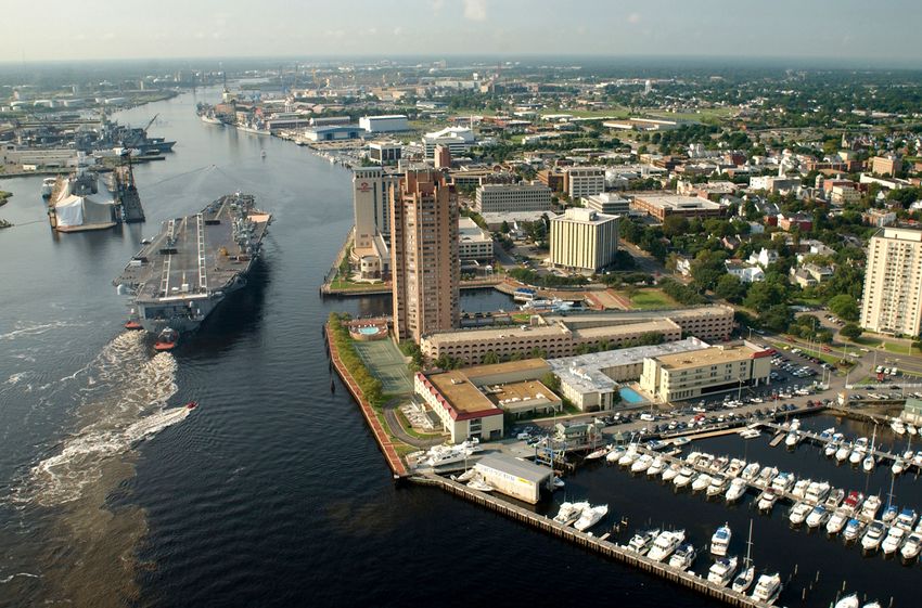
parking.
The USS George W Bush in drydock at Norfolk Naval Shipyard.
Source: navsea.navy.mil
28Waterfront
Redevelopment
– There is interest in establishing an
Enhanced Use Lease (EUL) for
parts of South Gate Annex and
potentially areas on St. Juliens
Creek Annex that are underutilized.
– Access to a deep-water shipping
channel, utilities, adjacency to
industrial activities are strengths in
this vicinity
– The Navy is current evaluating EUL
options.
29
= Potential EUL SiteCoordination + Communication 30 Portsmouth and Chesapeake JLUS
Coordination and Communication Can
     Be Strengthened

• There are well-established mechanisms in place to promote coordination
  between Portsmouth, Chesapeake and the Navy
• Navy Community Plans and Liaison Officers (CPLO) at each installation
  are primary points of contact
• Cities have multiple points of contact
• Several regional projects are underway or in progress that will require
  increased coordination
• Other issues that would benefit from increased coordination:
    • Transit
    • Recreation
    • Emergency response
    • Railroad growth
    • Parking coordination and enforcement

31                            Portsmouth and Chesapeake JLUS
Strategy Development 32 Portsmouth and Chesapeake JLUS
Strategy Types and Criteria

Strategy Types                              Criteria
– Flood Mitigation                          – DOD Mission and Personnel
– Access and Parking                          Readiness

– Land Use and Utilities                    – Transportation Network
                                              Connectivity
– Policies
                                            – Community Benefits
– Coordination and
  Communication                             – Economic Resiliency

33                         Portsmouth and Chesapeake JLUS
Next Steps 34 Portsmouth and Chesapeake JLUS
Project Website
       www.hrpdcva.gov/portsmouth-chesapeakeJLUS

35                     Portsmouth and Chesapeake JLUS
Opportunities for Input
Your attendance will automatically add you to our
stakeholder list
Visit the Project Website for updates and to submit
comments via an online form
Email Ben McFarlane, Senior Regional Planner
Hampton Roads Planning District Commission
bmcfarlane@hrpdcva.gov
www.hrpdcva.gov/portsmouth-chesapeakeJLUS
36 Portsmouth and Chesapeake JLUSYou can also read