Potential cumulative impacts of proposed activities and developments on the environmental, social and cultural values of Exmouth Gulf - in ...
←
→
Page content transcription
If your browser does not render page correctly, please read the page content below
Potential cumulative impacts of proposed activities
and developments on the environmental, social and
                    cultural values of Exmouth Gulf
                   in accordance with section 16(e) of the
                       Environmental Protection Act 1986

                             Environmental Protection Authority

                                                   August 2021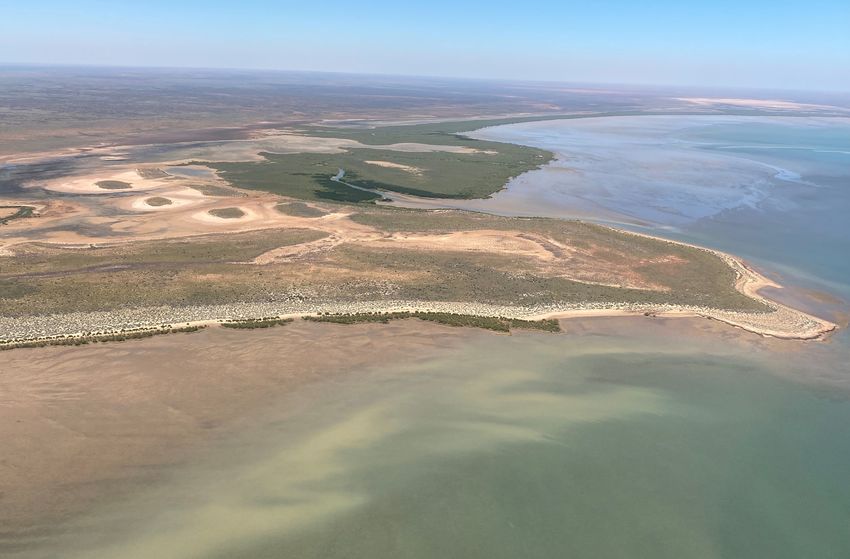
The EPA acknowledges the traditional custodians of the Exmouth Gulf and its surrounds – the Baiyungu,
    Yinikurtira and Thalanyji people – and pays respect to their Elders past, present and emerging. The
    EPA acknowledges the Nganhurra Thanardi Garrbu Aboriginal Corporation in sharing its values and
    knowledge of Exmouth Gulf in the EPA’s preparation of this advice.

    Environmental Protection Authority 2021, Potential cumulative impacts of proposed activities and
    developments on the environmental, social and cultural values of Exmouth Gulf in accordance with section
    16(e) of the Environmental Protection Act 1986, EPA, Western Australia.

    This document is available in alternative formats upon request.

    National Relay Service
    TTY: 133 677
    (To assist persons with hearing and voice impairment)

    More information

    EPA Services
    Department of Water and Environmental Regulation
    Prime House
    8 Davidson Terrace
    Joondalup WA 6027

    Locked Bag 10
    Joondalup DC, WA 6919

    p: 08 6364 7000
    e: info.epa@dwer.wa.gov.au
    w: www.epa.wa.gov.au

    Cover image: Exmouth Gulf © Wendy Thompson 2021

2   Exmouth Gulf section 16(e) advice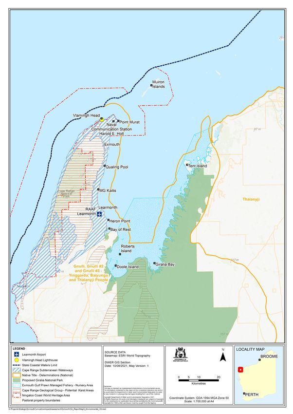
Contents
Summary���������������������������������������������������������������������������������������������������������������������������������������������������������� 5
1 Introduction������������������������������������������������������������������������������������������������������������������������������������������������� 8
1.1 Overview of Exmouth Gulf��������������������������������������������������������������������������������������������������������������������13
1.2 Relevant policy, legislation and management �����������������������������������������������������������������������������������15
2 Key values and pressures������������������������������������������������������������������������������������������������������������������������ 17
2.1 State of values in Exmouth Gulf�����������������������������������������������������������������������������������������������������������17
2.2 Existing and forecasted pressures������������������������������������������������������������������������������������������������������22
2.3 Potential cumulative impacts of current and proposed projects����������������������������������������������������24
3 Advice and recommendations���������������������������������������������������������������������������������������������������������������� 34
3.1 Protecting the key values of Exmouth Gulf and its surrounds��������������������������������������������������������34
3.2 Assessing future compatibility in Exmouth Gulf and its surrounds������������������������������������������������35
3.3 Integrating management of the land and sea environment of Exmouth Gulf������������������������������36
4 Conclusion������������������������������������������������������������������������������������������������������������������������������������������������� 38
References����������������������������������������������������������������������������������������������������������������������������������������������������� 39
Tables
Table 1: Government role in Exmouth Gulf....................................................................................................15
Table 2: EPA’s key values of concern for future development compatibility and consideration of
potential cumulative impacts. The consideration of values of concern includes both existing and
potential future activities exerting pressure, organised alphabetically ......................................................26
Table 3: Values under high risk from current and proposed activities, organised by key sector-based
pressures. Note, not all values-by-sector-based pressure combinations were evaluated (e.g. land
values weren’t evaluated against pressures from the fishing sector) ........................................................28
Figures
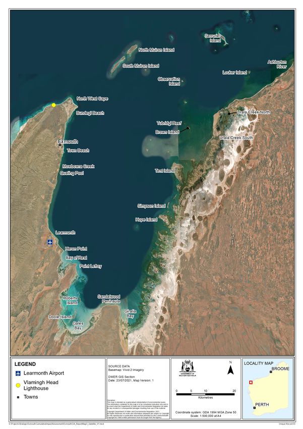
Figure 1: Regional location of Exmouth Gulf with key land tenure and proposal boundaries ................11
Figure 2: Locations of interest in Exmouth Gulf ............................................................................................12
Figure 3: Sea theme conceptual diagram – pathways illustrating consideration of pressures acting on
values, in isolation to consideration of connectivity between pressures acting on values (i.e. potential
cumulative impacts). EPA factors presented are indicative of key values. Sector-based pressures
evaluated against the sea theme included: climate change, mining, fishing, tourism and visitation, and
shipping ..............................................................................................................................................................30
Figure 4: Exemplar diagrams illustrating network pathways for potential connectivity and cumulative
impacts between key values and pressures of concern for (a) sea theme – benthic communities
and habitats, marine fauna, coastal processes, and marine environmental quality; (b) land theme –
subterranean fauna, landforms, terrestrial environmental quality and water theme – inland waters; (c)
people theme – social surroundings, land theme – terrestrial fauna and flora and vegetation, and sea
theme – marine fauna .......................................................................................................................................31
Exmouth Gulf section 16(e) advice 3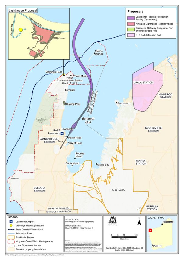
Appendices
    Appendix A: Initiation of section 16(e) advice ...............................................................................................41
    Appendix B: Additional reference maps.........................................................................................................44
    Appendix C: Supporting information WAMSI report.....................................................................................46
    Appendix D: List of contributors......................................................................................................................47
    Appendix E: Summary of public submissions (October–November 2020).................................................50
    Appendix F: Exmouth community meeting summary...................................................................................51
    Appendix G: Conceptual diagrams for EPA themes – potential cumulative impacts pathways...............52

4   Exmouth Gulf section 16(e) advice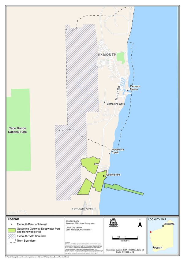
Summary
This report provides the Environmental Protection Authority’s (EPA) advice to the Minister for
Environment under section 16(e) of the Environmental Protection Act 1986 on the potential cumulative
impacts of proposed activities and developments on the environmental, social and cultural values of
Exmouth Gulf.

Exmouth Gulf and the surrounding area are recognised as significant and valuable assets for Western
Australians, and their unique environmental, social and cultural values are acknowledged globally. Many
of the ecological communities and species assemblages associated with the Gulf area are geographically
distinct and are at the limit of their ranges (e.g. tropical-arid mangrove community). The EPA considers
that there is an opportunity to protect and enhance the current state of these key values. This includes
incorporating the knowledge and values of the traditional owners by ensuring they are key partners in the
future environmental protection and management.

The EPA recognises that Exmouth Gulf is under increasing pressure from uncoordinated human activities
and development. The values of the Gulf are fragile and there is a risk that impacts from existing and
potential pressures may not be sustainable when considered cumulatively. An integrated management
approach should be adopted to address the multiple uses and cumulative pressures in the Gulf.

The health and connectivity of the environmental, social and cultural values of Exmouth Gulf are
dependent on continued investment in protection and conservation with respect to its globally-significant
geographical location, biodiversity, productivity and ecological function. The land and sea environments
of the Gulf are interdependent ecosystems, and vital to the health and connectivity to the Ningaloo Coast
World Heritage Area and the broader Pilbara coast.

The EPA considers that the cumulative impacts study and provision of strategic advice to the Minister is
applicable to decision-makers and proponents alike. The EPA submits recommendations and advice to
the Minister for Environment around three themes:
1. protecting the environmental, social and cultural values of Exmouth Gulf and its surrounds
2. EPA expectations for assessing future compatibility of activities and developments in Exmouth Gulf
   and its surrounds
3. integrating management of the land and sea environment of Exmouth Gulf.

Protecting the environmental, social and cultural values of Exmouth Gulf and its surrounds
The key values of Exmouth Gulf are described in section 2 of this report. While key values were identified
across the entire Gulf and its surrounds, the EPA considers the eastern and southern portions of the Gulf
to be critical environmental assets of exceptional value that should be protected. The values are under
increasing pressure from existing and proposed activities and development, so formal protection should
be a high priority.

The EPA recommends a very high level of protection for the eastern and southern portion of Exmouth
Gulf and adjacent hinterland (e.g. coastal dunes and coastal plains), and that the establishment of marine
and terrestrial protected areas is co-designed with traditional owners as partners in its future protection
and management. The EPA recommends that the protected areas should encompass both the land and
sea environment to capture the important connectivity and ecological function between landscapes,
including the intertidal and supratidal flats.

The EPA also recommends a high level of protection for key values that are of local significance for
Exmouth Gulf, including sensitive areas such as Qualing Pool, Camerons Cave, Cape Range Subterranean
Waterway and the islands of Exmouth Gulf.

                                                                              Exmouth Gulf section 16(e) advice   5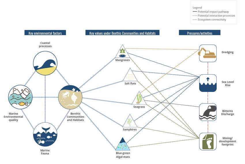
EPA expectations for assessing future compatibility of activities and developments in Exmouth Gulf and its
    surrounds
    The EPA recommends that any future activities and development must be compatible with the protection
    of the key values. The EPA will apply particular scrutiny to activities and developments that may be
    incompatible with the protection of the key values, including values of local significance for Exmouth Gulf.
    The EPA also recommends a review and update of relevant environmental policy, planning and guidance
    mechanisms to align with the advice and recommendations in this report.

    The EPA expects the following in its consideration of future activities and developments in Exmouth Gulf
    and its surrounds:

    1. Broad regional context
        Proposed activities and developments will need to demonstrate compatibility with the protection
        of key values in Exmouth Gulf and its surrounds. The values of the land and sea environments are
        unique assets of global significance and the consideration of any potential impacts to those values
        requires a precautionary approach. There is an opportunity to strengthen the protection of the Gulf
        through avoidance of activities and developments that could use alternative locations. The features
        of the Gulf that make it suitable for many proposed activities and developments are also present
        in other Western Australian coastal locations. These alternative locations have access to existing
        infrastructure, and sites that have already experienced a level of environmental disturbance.

    2. Critical site selection
        Within Exmouth Gulf, avoidance of environmental disturbance should be a key consideration for
        all new developments in site selection. There are opportunities to concentrate activities in existing
        disturbance sites, which is consistent with the mitigation hierarchy. The EPA will scrutinise activities
        and developments that affect key values of local significance.

    3. Protect key social surroundings values
        Proponents of activities and developments will need to demonstrate explicit regard and protection
        of the Aboriginal heritage and culture; values of dark sky and low atmospheric pollution; and local
        heritage and identity, which are critical assets of the social surroundings in Exmouth Gulf.

    4. Adaptable design and infrastructure
        The EPA will scrutinise activities and developments that lock in pressures or impacts for long periods
        or are likely to induce cumulative impacts. Proponents of activities and developments will need to
        demonstrate adaptability in design and approach to protect the key values and ecological processes
        in a dynamic ecosystem. The EPA recognises that some key values of Exmouth Gulf are already under
        pressure from multiple activities. The EPA considers that adaptability in design is critical to ensuring
        ongoing protection and resilience of the dynamic Gulf ecosystem and its ecological processes and
        functions.

    5. Cumulative impacts
        The EPA will scrutinise proposals that have a potential impact on the key values of Exmouth Gulf
        in the context of existing and other reasonably foreseeable future activities and developments.
        Proponents of proposed activities and developments will be expected to demonstrate that the risks
        to key values will not be significantly elevated as a result of potential cumulative impacts. Proponents
        should demonstrate a comprehensive understanding of the environment they propose to operate in
        at a regional scale, including ecological connectivity, to improve consideration of cumulative impacts.
        The EPA notes that there are opportunities within the mitigation hierarchy to reduce cumulative
        impacts of proposed activities and development.

6   Exmouth Gulf section 16(e) advice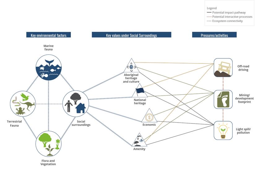
6.   Climate change considerations
     Climate change is a pervasive pressure affecting Exmouth Gulf that will interact with both existing and
     proposed pressures from activities and development. It has the potential to have a significant impact
     on environmental values. Proponents of activities and developments will be expected to evaluate
     how climate change is likely to interact with the existing and foreseeable future pressures as part of
     potential cumulative impacts, and to include measures demonstrating adaptation and resilience to
     climate change.

Integrating management of the land and sea environment of Exmouth Gulf
The EPA recommends an integrated management approach to ensure the conservation and
enhancement of the key values of Exmouth Gulf.

An integrated management approach has been applied to other multi-use locations, such as Cockburn
Sound, Leschenault, Peel Harvey and Vasse Geographe Catchment areas. These approaches should be
evaluated to guide the establishment of an integrated approach that is appropriate for the management
and protection of the key values of Exmouth Gulf.

The EPA recommends establishing a coordinating body, with clearly defined roles in the environmental
protection, planning and management of Exmouth Gulf and its surrounds.

The EPA acknowledges that significant knowledge gaps exist for Exmouth Gulf, relevant to the advice
and recommendations in this report. The EPA emphasises the opportunity to address these knowledge
gaps to support environmental protection, consistent with the EPA’s objectives, which informs policy and
decision-making relevant to the Gulf.

                                                                           Exmouth Gulf section 16(e) advice   7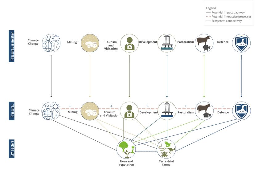
1       Introduction
    On 19 August 2020, the then Minister for Environment (Minister) requested the Environmental Protection
    Authority (EPA) provide advice under section 16(e) of the Environmental Protection Act 1986 (EP Act) on the
    potential cumulative impacts of proposed activities and developments on the environmental, social and
    cultural values of Exmouth Gulf (see Appendix A). Specifically, the request sought advice on the:
    1. current state of the key environmental, social and cultural values in Exmouth Gulf
    2. potential impacts on those values posed by existing activities and developments including, but not
       limited to, industrial activity (including oil and gas support), transportation and logistics operations,
       commercial and recreational fishing, and tourism
    3. potential impacts on those values by proposed activities and developments including, but not limited
       to, the Subsea 7 proposal, the Gascoyne Gateway proposal, and the K+S salt proposal
    4. compatibility of future developments with the key environmental, social and cultural values in the
       Exmouth Gulf.

    As part of the functions of the EPA in the EP Act, section 16(e) provides that the EPA may ‘advise the
    Minister on environmental matters generally and on any matter which the Minister may refer to it for
    advice, including the environmental protection aspects of any proposal or scheme, and on the evaluation
    of information relating thereto’.

    This report presents the EPA’s advice pursuant to section 16(e) of the EP Act. The environmental, social
    and cultural values considered are in accordance with the definitions under the EP Act and the EPA’s
    framework of environmental factors and objectives (EPA 2020).

    The EPA recognises the increasing importance of assessing and managing cumulative environmental
    impacts. This is established in section 3(2)(1B) of the amended EP Act, where the assessment of proposals
    includes the consideration of cumulative effects of the impacts of a proposal. The assessment of
    cumulative impacts broadly encompasses the successive, incremental and combined impacts of one or
    more activities on the environment, arising from past, present and reasonably foreseeable future actions.
    Consideration of cumulative impacts shifts the focus from a single activity, development or proposal to
    the receiving environment as a whole.

    There are a number of existing and new proposals in the Exmouth Gulf area that are relevant to the
    Minister’s request for advice, including:
    •   K+S Salt Australia Pty Ltd’s Ashburton Salt Project
    •   Gascoyne Gateway Ltd’s Single Jetty Deep Water Port and Renewable Hub
    •   Z1Z Resorts Pty Ltd’s Ningaloo Lighthouse Resort Project
    •   Main Roads Western Australia’s Yardie Creek Road Realignment Project.

    It should be noted that, since initiation of this strategic advice, Subsea 7’s Learmonth Pipeline Fabrication
    Facility proposal and the related Shire of Exmouth’s Local Planning Scheme 4 Amendment 1 have both
    been terminated. Therefore, the scope of this strategic advice does not provide consideration of these
    activities.

    The cumulative impacts study presented in this report was conducted at a strategic level, drawing upon
    existing scientific evidence, expert advice and stakeholder knowledge. The potential impacts of the
    existing and new proposals listed above were considered in the provision of this advice; however, this
    report and supporting information should not be construed as being detailed assessments of those
    proposals.

8   Exmouth Gulf section 16(e) advice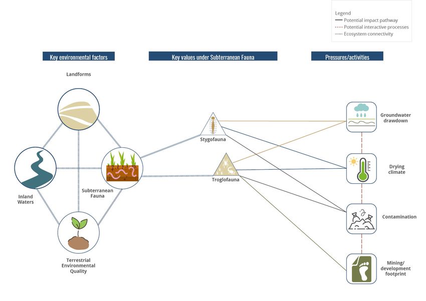
Location
For the purpose of this strategic advice, the EPA has characterised the spatial extent of Exmouth Gulf as
the entire portion of state coastal waters located between the North West Cape peninsula, the Muiron
Islands and mainland Western Australia (WA), and the adjacent land from Vlamingh Head to Urala Station
(see Figure 1).

The scope of this advice is inclusive of key locations on the western side of Exmouth Gulf, including
the town of Exmouth and adjacent road infrastructure, Vlamingh Head Lighthouse, MG Kailis Fisheries,
and the Australian Department of Defence (Defence) lands and facilities. While this advice does not
provide explicit consideration of the western portion of North West Cape peninsula (that being the Cape
Range National Park and Ningaloo Marine Park), the EPA provides this strategic advice with a holistic
consideration due to the inherent complexity and integrated connectivity between the Exmouth Gulf and
adjacent land and sea environments.

The geographic context and key named features of Exmouth Gulf are presented in Figures 1 and 2,
respectively. Figure 1 focuses on land tenure, project proposal footprints and other key spatial boundaries
(e.g. Ningaloo Coast World Heritage Area). Figure 2 provides reference information for select features
in Exmouth Gulf, which may be referenced specifically in the report. The two figures provide geographic
information referenced in the report; additional maps are provided in Appendix B.

Overview of approach
For delivery of this strategic advice, the EPA and the Department of Water and Environmental Regulation
partnered with the Western Australian Marine Science Institution (WAMSI), who contributed technical and
expert support on the values and pressures associated with Exmouth Gulf. The WAMSI report provides
information on:
•   The key values (environmental, social and cultural) of Exmouth Gulf – including current state of the
    values, and level of confidence pertaining to the values – in the form of a literature review aligned with
    the EPA’s environmental themes of sea, land, water, air and people.
•   The current and forecasted uses of Exmouth Gulf.
•   A qualitative risk assessment using a consequence versus likelihood approach to evaluate the impact
    or risk of a pressure against a key value. A detailed list of key values was consolidated at a high-level,
    prior to consideration in the qualitative risk assessment.
•   The relationship between key values and environmental pressures of Exmouth Gulf, derived from the
    qualitative risk assessment process.
•   Knowledge gaps that require further consideration to improve our understanding of Exmouth Gulf,
    identified against each EPA theme.

The WAMSI report forms the technical basis of the EPA’s strategic advice and provides key information
and materials that underpin the EPA’s recommendations. The WAMSI report and supporting
documentation have been appended to this advice (see Appendix C).

In preparing this strategic advice, the EPA engaged extensively with the public, Exmouth community,
and stakeholders across sectors to seek their input and improve the EPA’s understanding of the values,
activities and environmental pressures in and around Exmouth Gulf. A list of contributors and summaries
of input and consultation are provided in Appendices D, E and F.

Input received during the engagement process formed the basis of understanding a detailed list of key
values and pressures associated with Exmouth Gulf, including over 230 distinct values and more than 48
pressures. The values and pressures information has been consolidated and analysed for this strategic
advice.

                                                                             Exmouth Gulf section 16(e) advice   9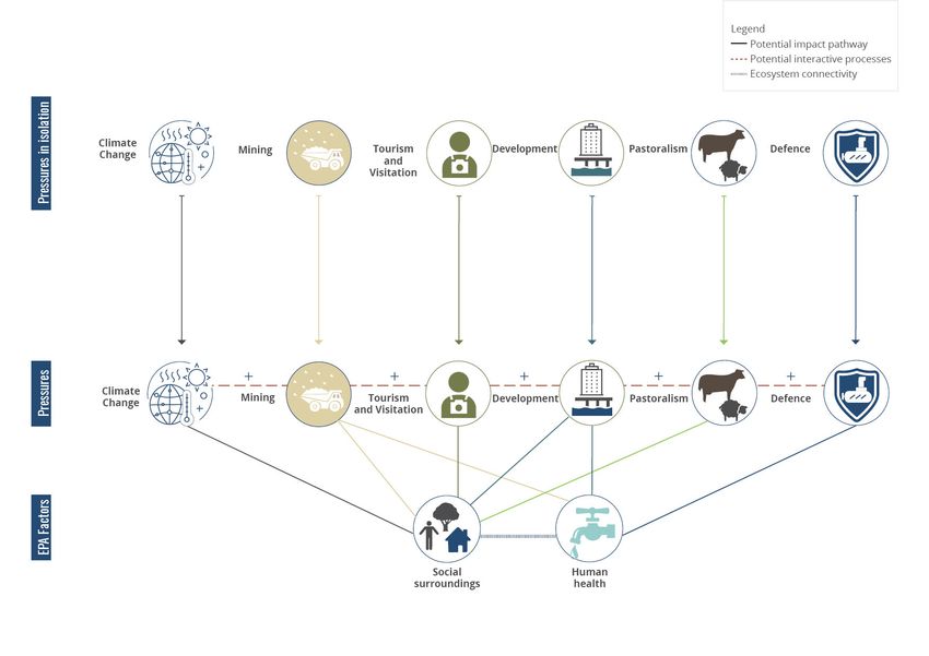
The EPA established an Exmouth Gulf Perspectives Group to support the process with the provision of
     advice and input encompassing a broad consideration of strategic issues pertaining to the Gulf. The
     group comprised six representatives from the following sectors: conservation; marine environment
     and fisheries; Exmouth Gulf community; ports and development; traditional owners; management and
     environment.

     The EPA extends its appreciation to those who generously contributed to the strategic advice, particularly
     WAMSI, members of the Perspectives Group, the Nganhurra Thanardi Garrbu Aboriginal Corporation,
     the Exmouth community, and all those who made submissions or were interviewed during the process.
     Their continued willingness to engage and provide valuable information was crucial to this process. Any
     omissions from the list of contributors are unintentional.

     Terminology

     The following terms hold specific meaning for the purpose of this advice:
     Exmouth Gulf is used to describe both the sea and adjacent land components of the environment.
     Key values encompass the environmental, social and cultural values of Exmouth Gulf, in the context of
     the definitions in the EP Act and the EPA’s framework of environmental factors and objectives.
     Foreseeable future means within the next five to 10 years; except for references to climate change, which
     includes the next 20 years.
     Drivers and pressures are presented in the context of drivers-pressure-state-response model; with
     drivers being organised by sectors (e.g. shipping, fishing, mining, tourism/visitation, pastoralism and
     defence) or forces (e.g. climate change) that may cause change in a system. Pressures being the events
     resulting from the driver. For example, shipping would be the driver; vessel strike is a potential pressure
     under shipping.
     Cumulative impacts encompass the successive, incremental and interactive impacts of one or more
     activities on the environment, arising from past, present and reasonably foreseeable future activities. The
     EPA recognises that cumulative impacts may act in numerous ways, including additive or interactive.

     The above terms should be read as described, unless specified otherwise.

10   Exmouth Gulf section 16(e) advice
Figure 1: Regional location of Exmouth Gulf with key land tenure and proposal boundaries
Exmouth Gulf section 16(e) advice 11Figure 2: Locations of interest in Exmouth Gulf 12 Exmouth Gulf section 16(e) advice
1.1     Overview of Exmouth Gulf
Physical geography
The Exmouth Gulf is a large, shallow embayment located on the eastern side of the North West Cape
peninsula within the Carnarvon Bioregion and Cape Range subregion (CAR1; Thackway & Cresswell
1995). The physical geography of the area is characterised by limestone ranges, a fringing coral reef, and
sandplains and dunes surrounding the shallow embayment (Russell 2004). The physical landscape reflects
geologic processes spanning over 150 million years, including tectonic and sedimentary activity, the
separation of the Gondwanan supercontinent and changes in climate and sea levels (Russell 2004). The
region is typified by semi-arid to arid, sub-tropical climate and vegetation, characterised by the possibility
of significant cyclonic activity (Kendrick & Mau 2002; Beard 2015).

The broad scale geomorphology of the North West Cape peninsula is composed largely of tertiary
and quaternary marine limestone and sediments (Wyrwoll et al. 1993; Kendrick & Mau 2002). Alluvial
sediments and coast deposits predominantly form the western Exmouth Gulf foreshore (Wyrwoll et
al. 1993), characterised by narrow coarse-grained pebble beaches abutting low intertidal limestone
platforms (Kolkovski & Machin 2004).

The southern and eastern shores of Exmouth Gulf are comprised primarily of extensive mud flats and
sand flats, with infrequent occurrences of limestone platforms and coral outcrops (Kolkovski & Machin
2004). Well-developed tropical-arid zone mangroves and blue-green algal mats are the dominant
benthic communities and habitats along the southern and eastern shores of the Gulf and behind these
communities is an extensive tidal salt flat up to 15 kilometres wide. The low-lying mud, sand and salt flat
areas are subject to large-scale inundation, particularly during storm and cyclone surge events (Kolkovski
& Machin 2004).

The North West Cape peninsula is dominated by the Cape Range landform, characterised by rugged
topography and a maximum elevation of about 300 metres, adjacent to the relatively flat coastal plains
and dunes adjacent to Exmouth Gulf (Allen 1993; Kolkovski & Machin 2004). The Cape Range landform
consists of sandstone and limestone formations, including the Tulki and Trealla Limestones that contain
extensive karst features such as caves and subterranean waterways.

The eastern Exmouth Gulf hinterland is primarily coastal deposits, sand dune and plains and alluvial
plains and valley systems, characterised primarily by low topography (Wyrwoll et al. 1993; Van de Graaff
et al. 1980). The southern Exmouth Gulf hinterland is characterised by more prominent topographical
relief, including the Giralia Range.

Human occupation and Exmouth settlement
The North West Cape peninsula has been utilised by the Baiyungu, Yinikurtira and Thalanyji (also
known as Jinigudira) people for at least 30,000 years (Morse 1993). The Exmouth Gulf and its surrounds
(including inshore islands) remain a significant area for traditional owners, represented by registered and
unregistered cultural heritage sites and continued use for cultural practices. These cultural practices are
sophisticated, reflecting deep understanding of the environmental systems of Exmouth Gulf and the
importance of ongoing stewardship and management by traditional owners (DBCA 2020a).

The town of Exmouth was established to provide services to the United States Naval Communication
Station Harold E. Holt and the Learmonth Royal Australian Air Force (RAAF) Base in the 1960s. The town
remains closely connected to Australian Defence services and operations. In addition to the defence
industry, the Exmouth economy is largely driven by tourism and visitation to the region, including the
Ningaloo Coast World Heritage Area, Cape Range National Park, and the Exmouth Gulf.

                                                                            Exmouth Gulf section 16(e) advice    13
The Shire of Exmouth experienced population growth of 20 per cent from 2006 to 2016, reporting a
residential population of 2,486 in 2016 (ABS 2017). The population of the town of Exmouth fluctuates
significantly over the course of each year, expanding to over 6,000 people during the peak tourist season
(generally April to October each year) (Shire of Exmouth n.d.).
The EPA received detailed public input regarding the strong connection the Exmouth Gulf community has
with their local environment, and the recognition of the unique location of their town in close proximity to
globally significant environmental assets (see Appendices D and E).
Land tenure and use of Exmouth Gulf
Current land tenure surrounding Exmouth Gulf is provided in Figure 1. Land tenure in and around the
Gulf is dominated by Crown land and leases, reserves, freehold land and Unallocated Crown Land (UCL).
Freehold land is concentrated around the town of Exmouth, and to its immediate south, including land
designated for residential, commercial and industrial purposes. The dominant land uses outside the town
of Exmouth includes defence, pastoral activities (i.e. grazing permitted stock), conservation and mining/
exploration leases (Kendrick & Mau 2002).
Crown lease tenure includes six pastoral stations adjacent to Exmouth Gulf, with boundaries of coastal
pastoral stations extending to 40 metres above the high-water mark. The pastoral stations in the region
are primarily stocked with cattle. Exmouth Gulf Station and Bullara Station have obtained diversification
permits under the Land Administration Act 1997, which allow for pastoral based tourism such as camping,
short-term accommodation and tours.
The Commonwealth of Australia is an important landowner within the region. The North West Cape
peninsula contains several Commonwealth land parcels used for Department of Defence purposes,
including the Learmonth RAAF Base, Naval Communication Station Harold E. Holt, and the Learmonth
Solar Observatory. The Shire of Exmouth leases the Learmonth airport from the Commonwealth for civil
aviation purposes, which services the local community and offshore operations.
Several inshore islands within the Exmouth Gulf embayment area are classified as nature reserve
within WA’s conservation estate. There are plans to increase the management and protection status of
inshore islands within the Gulf and along the Pilbara coast (DBCA 2020a). The northern portion of the
Gulf overlaps with the Ningaloo Coast World Heritage Area, including nature reserves and conservation
areas within the Muiron Islands Management Area (CALM 2005; UNESCO 2011). The northern portion of
the Gulf within the World Heritage boundary also contains areas designated for general use, recreation
and sanctuary zones. The Exmouth Gulf inshore islands and Ningaloo Coast World Heritage areas are
managed by the Department of Biodiversity, Conservation and Attractions (DBCA).
The southern and eastern portions of Exmouth Gulf are adjacent to the ex-Giralia pastoral station,
currently owned and managed by DBCA. The tenure of ex-Giralia is currently UCL and managed for
conservation purposes. Ex-Giralia and a large portion of the east coast of Exmouth Gulf is proposed for
inclusion in WA’s conservation estate as part of the State Government’s Plan for Our Parks (DBCA 2019).
Native Title was granted in 2019 to the Baiyungu, Yinikurtira and Thalanyji (also known as Jinigudira)
people for areas across the Gascoyne region (WCD2019/016). The Nganhurra Thanardi Garrbu Aboriginal
Corporation is the prescribed body corporate for management and protection of the land and sea
country of Exmouth Gulf. The corporation has entered into Indigenous Land Use Agreements (ILUAs) and
Joint Management Agreements with the State Government through DBCA for some parts of the North
West Cape peninsula, including areas within and adjacent to the Ningaloo Coast World Heritage area
(WI2020/011).
14 Exmouth Gulf section 16(e) advice1.2 Relevant policy, legislation and management
Exmouth Gulf represents a demarcation between the Gascoyne and Pilbara administrative regions. The
western and southern land portions are governed by the Shire of Exmouth, while the eastern land portion
falls within the Shire of Ashburton (see Figure 1).
Planning activities and related decision-making in the Exmouth area is subject to the Western Australian
planning framework, including the State Planning Policy 6.3 – Ningaloo Coast (WAPC 2004) (SPP 6.3). The
EPA considers the guiding principles and policy objectives of SPP 6.3 remain relevant and valuable for
planners, developers and planning decisions in Exmouth Gulf.
As part of the engagement process for this strategic advice, the EPA requested advice across government
for transparency in utilisation of Exmouth Gulf (see Appendices D and E). Table 1 provides information
regarding the key agencies, and government role for activities in the Gulf.
Table 1: Government role in Exmouth Gulf
Government agencies Role in Exmouth Gulf Key legislation
and organisations
Australian Bureau of Joint operation of the Learmonth Meteorology Act 1955
Meteorology (BOM) Solar Observatory (Commonwealth)
Australian Department of Operation of key infrastructure and Defence Act 1903
Defence (Defence) air space (Commonwealth)
Department of Management of land and sea Biodiversity Conservation Act 2016;
Biodiversity, Conservation reserves Conservation and Land Management
and Attractions (DBCA) Act 1984
Department of Jobs, Lead agency for State significant Government Agreements Act 1979
Tourism, Science and projects and State Agreements
Innovation (DJTSI)
Department of Planning, Administration of pastoral leases Land Administration Act 1997
Lands and Heritage (DPLH) and other Crown lands
Department of Primary Management of commercial and Biosecurity and Agriculture
Industries and Regional recreational fisheries; Biosecurity Management Act 2007; Fish
Development (DPIRD) management Resources Management Act 1994
Department of Water and Management and regulation of the Environmental Protection Act 1986;
Environmental Regulation environment and water resources Rights in Water and Irrigation Act
(DWER) 1914
Department of Transport Operation of Exmouth Boat Harbour Marine and Harbours Act 1981
(DoT)
Ningaloo Coast World Provides advice to Commonwealth Environment Protection and
Heritage Advisory and State on all matters regarding Biodiversity Conservation Act 1999
Committee (NCWHAC) the World Heritage Area (Commonwealth)
Pastoral Lands Board Administration of pastoral leases Land Administration Act 1997
(delivered through DPLH)
Shire of Ashburton Local Government Act 1995;
Local government authorities Planning and Development Act 2005
Shire of Exmouth
Tourism WA Tourism development and Western Australian Tourism
(delivered through DJTSI) opportunities in Exmouth Commission Act 1983
Exmouth Gulf section 16(e) advice 15The EPA notes that, while the above government agencies have a role in Exmouth Gulf, the coastal waters
and foreshore areas lack Gulf-wide coordination and management.
Previous recommendations by government for Exmouth Gulf
Exmouth Gulf has been the subject of various advice and recommendations by State and Commonwealth
Government over the past 50 years.
The eastern and southern portions of Exmouth Gulf, including nearshore waters, have been recognised as
a significant environmental asset since the 1970s (EPA 1975), with recommendations for inclusion in the
WA conservation estate multiple times since the 1990s (CALM 1994). Exmouth Gulf was also considered in
conjunction with the Ningaloo Reef for World Heritage listing; however, the final boundary for the World
Heritage area excluded most of the Gulf (WHCC 2005; UNESCO 2011).
16 Exmouth Gulf section 16(e) advice2 Key values and pressures
This section addresses the key questions from the Minister’s request (see Appendix A):
• section 2.1 addresses the current state of the key environmental, social and cultural values in
Exmouth Gulf
• section 2.2 addresses the potential impacts on key values posed by existing and proposed activities
and developments
• section 2.3 addresses the compatibility of future developments with key values in Exmouth Gulf.
The EPA’s advice and recommendations relating to the above are provided in section 3.
2.1 State of values in Exmouth Gulf
The EPA has considered the key values of Exmouth Gulf within the context of the definitions under the
EP Act and the EPA’s framework of environmental factors and objectives (EPA 2020). This comprises 14
environmental factors across five themes (sea, land, water, air and people; EPA 2020). A complete list of
the key values considered in this process are referenced in Appendix C.
The EPA’s framework, which is applied in the assessment of proposals and schemes under Part IV of the
EP Act, provided a useful structure for organising environmental information in the preparation of this
report.
The current state (i.e. condition) of all key values in Exmouth Gulf were evaluated on a scale ranging
from very good to very poor, based on existing knowledge gathered through relevant scientific and
other literature and expert input. Based on the preliminary evaluation of key values, no key values were
categorised in a state of very poor condition (see Appendix C). Most key values were considered as good
or very good condition; however, the EPA notes uncertainty is associated with the scoring of key values.
The EPA acknowledges that a lack of data and lack of understanding of the ecological system underpins
the considerable uncertainty about the state of many of the key values. Key values found to be in a poor
state should be the subject of further on-ground investigation and management to validate findings and
ensure current state conditions do not deteriorate to unsustainable levels through further activities and
development, particularly from cumulative impacts.
The EPA provides the following information regarding the key values of Exmouth Gulf, and current state
of these values within each of the EPA’s five themes. Section 2.3 provides a summary of the key values of
most concern across all themes (see Table 2).
Sea
EPA factors: benthic communities and habitats; coastal processes; marine environmental quality; and marine
fauna.
The sea environment of Exmouth Gulf is inherently connected and ecologically interdependent with the
adjacent Ningaloo Reef and Pilbara coast.
The coastal waters of Exmouth Gulf are characterised as a shallow and turbid embayment, with primarily
soft sediment communities dispersed with limestone reefs and coral bommies. Seagrass is found in
the shallow waters of the Gulf, which provide important feeding habitat for marine turtles and dugongs
(Dugong dugon). Sponges and filter feeders are associated with hard limestone areas with more significant
communities occurring in deeper water. Corals occur at Bundegi Reef, on isolated shoals and at low
densities on the pavement reefs.
Exmouth Gulf section 16(e) advice 17Exmouth Gulf is a significant location for marine fauna due to the relatively sheltered waters and diversity
of habitats, resulting in a biodiverse range of species including marine mammals, invertebrates, teleost
fish, elasmobranchs, and seabirds and shorebirds (Fitzpatrick et al. 2019).
The sea environment of Exmouth Gulf is an important location for humpback whales (Megaptera
novaeangliae), particularly for mother and calf pairs resting during seasonal migration. In addition, the
Gulf has significant habitat for many other conservation significant fauna (e.g. marine turtles, dugongs,
sawfish (Pristis spp.), sea snakes and whale sharks (Rhincodon typus)) and charismatic marine fauna (e.g.
dolphins and manta rays). Both traditional owners and the Exmouth community identified strongly with
the values associated with marine fauna.
The embayment also supports populations of marine fauna targeted for commercial purposes, including
the brown tiger prawn (Penaeus esculentus), western king prawn (Penaeus latisulcatus) and blue endeavour
prawns (Metapenaeus endeavouri), which are targeted species for prawn trawlers as part of the Exmouth
Gulf Prawn Managed Fishery.
East Exmouth Gulf
The eastern and southern portions of Exmouth Gulf are relatively intact environments with wide coastal
mudflats, tidal creeks, fringing mangroves, and algal mats dominating the landscape. This area includes
the largest discrete community of mangroves in WA, outside of the Kimberley region (ANCA 1996).
The entirety of the east coast of Exmouth Gulf, including the salt flats and sand dunes, is listed as a
wetland of national importance (WA007) due to its significant environmental values and ecological
function. The benthic habitats and communities of east Exmouth Gulf significantly contribute to fuelling
productivity within the larger embayment and provides significant feeding habitat for dugongs and
marine reptiles, and nursery habitats for marine fishes and crustaceans (WHCC 2005).
Mangrove communities in the eastern and southern portions of Exmouth Gulf also support an important
shorebird population. The area is recognised as a nationally and internationally significant bird area due
to species abundance and presence of migratory species.
The eastern portion of Exmouth Gulf is largely uninhabited and inaccessible from the land due to its
remote location and challenging terrain, although intermittent access occurs via small boats during
optimal tidal and weather conditions. Prawn trawlers do not operate within nearshore areas of the
eastern and southern portions of Exmouth Gulf, as these are designated nursery areas within the
Exmouth Gulf Prawn Managed Fishery (DPIRD 2018; see map reference in Appendix B).
The EPA considers the eastern and southern portions of Exmouth Gulf are critical assets to WA and
require a very high level of protection. The EPA makes a specific recommendation in this regard (see
section 3.1).
Current state
The current state of values for benthic communities and habitats, marine environmental quality, and
coastal processes of Exmouth Gulf ranges from poor to very good (see Appendix C). Coral communities
were found to be in a poor state due to sensitivity to bleaching after marine heat stress events, and the
presence of coral rubble in some portions of the embayment suggested degradation of coral over time.
The current state of values for marine fauna ranges from very good to poor condition. Humpback whales
were the only marine fauna categorised as in very good state for Exmouth Gulf; the EPA considers
that this rating may be an outcome of the protection and management associated with the species
listing under both the Environment Protection and Biodiversity Conservation Act 1999 and the Biodiversity
Conservation Act 2016. Marine fauna values found to be in a poor state include marine reptiles (sea snakes
and marine turtles), dugongs, and seabirds and shorebirds. These values were determined to be in a
poor state as a result of their conservation significance, regional and global population decline, historical
harvesting
18 Exmouth Gulf section 16(e) advicerates for marine turtles and dugongs, and distinct habitat requirements, which are threatened by
competing activities and use.
Further, seabirds and shorebirds were found to be in poor condition, primarily due to direct disturbance
of burrows and nests from trampling and unmanaged off-road vehicles on foreshore and coastal dune
areas.
The current state of teleost fish (e.g. bony fish), shovelnose rays, sawfish and dolphins in Exmouth Gulf
are unknown due to a lack of information. However, anecdotal evidence suggests the current state of
some teleost fish species such as trevally, red emperor and coral trout populations may be poor due to
their popularity as targeted recreational fishing species.
Mangrove, algal mats and samphire communities on the eastern and southern portions of Exmouth Gulf
are in good to very good condition, due to the remoteness of the location and lack of anthropogenic
impacts. The EPA considers that these intertidal communities should be retained intact because of their
ecological connectivity to the whole of the Gulf. As such, these intertidal communities should be protected
due to their environmental significance and important ecological function.
Land
EPA factors: flora and vegetation; landforms; subterranean fauna; terrestrial environmental quality; and
terrestrial fauna.
Exmouth Gulf represents a climatic transitional zone between the temperate winter rainfall zone to the
south, and the tropical summer rainfall zone to the north (CALM 2004). The hinterland of the Gulf is
characterised by limestone ranges, sand dune systems, coastal plains scrub and shrublands.
Coastal plain areas are characterised by Acacia shrublands and Triodia hummock grasslands. The Cape
Range peninsula limestone ranges support endemic and priority flora species, and disjunct populations of
flora and vegetation at the extent of their range. Systematic biological surveys, including identification and
mapping of flora and vegetation communities outside of the Cape Range peninsula have been identified
as key knowledge gaps for the region.
Terrestrial fauna in the area is typical of north-west coastal regions in WA; however, some reptile species
are endemic, and some reptile and amphibian populations represent unique species assemblages and
disjunct populations at the extent of their ranges.
Small islands are present along the shallow, nearshore areas in the eastern and southern portion of
Exmouth Gulf, providing critical refugia for mammals, reptiles, and seabirds and shorebirds. The inshore
islands of Exmouth Gulf are considered significant and sensitive locations due their remoteness and
provision of habitat for conservation significant flora and fauna (DBCA 2020a).
The Cape Range Subterranean Waterway runs the length of the eastern portion of Cape Range peninsula
(see Appendix B) and is listed as a wetland of national importance (WA006) due to the significant presence
of locally endemic subterranean fauna (stygofauna and troglofauna).
The Cape Range karst system spans the Cape Range peninsula and is characterised as a series of arid
subterranean landscapes, including caves, subsurface streamways and limestone formations (DEC 1998).
The karst system provides critical habitat for unique assemblages of troglofauna including the Camerons
Cave Troglobitic Threatened Ecological Community (TEC) and conservation significant stygofauna such as
the blind cave eel (Ophisternon candidum) and blind gudgeon fish (Milyeringa veritas).
Current state
The state of most land-based values, including terrestrial fauna, subterranean fauna, and terrestrial
environmental quality, could not be determined due to a lack of available information (see Appendix C).
Exmouth Gulf section 16(e) advice 19The current state of values for flora and vegetation ranged from good to poor condition, with coastal
dunes in Exmouth Gulf considered poor primarily due to extensive degradation of dune vegetation from
off-road vehicles and unmanaged camping.
The current state of the inshore island values of Exmouth Gulf are described as in good condition. The
EPA considers that, given the environmental significance and sensitivity of the inshore islands, the inshore
island of Exmouth Gulf should be protected and the condition of the values improved.
The key values of the karst system, reptiles, amphibians, and all subterranean fauna are of concern due
to limited available information; therefore, a precautionary approach should be applied with respect to
activities and development that may impact them. The EPA also considers that protection status may be
appropriate for these values due to their environmental significance and sensitivity to change.
Air
EPA factors: air quality and greenhouse gas emissions.
Little information regarding the air quality of Exmouth Gulf could be sourced for this strategic advice,
reflecting a lack of relevant publications and studies. However, the EPA received advice from Defence and
the Learmonth Solar Observatory that air quality conditions in Exmouth are optimal for radio-frequency
communications, and space and solar observation activities due to the low atmospheric pollution, reliably
dark skies, and distance from industrial areas including heavy pollution emitters.
Current state
Based on the abovementioned advice from Defence, the air quality values in Exmouth Gulf are described
as being in very good condition (see Appendix C). The EPA notes the importance of preserving the very
good condition of air quality in Exmouth Gulf, so as not to interfere with the abovementioned activities,
as well as for reasons of human health and amenity and dark sky tourism (discussed below under People
theme). The EPA recognises the unique position of the North West Cape peninsula for its very good air
quality and dark sky values.
Water
EPA factor: inland waters.
The coastal waters of Exmouth Gulf are adjacent to, and connect with, the anchialine system of the Cape
Range karst and unconfined aquifer (WHCC 2005).
Groundwater quality of the Cape Range peninsula ranges from hypersaline to fresh and slightly brackish,
with groundwater flowing east from the Cape Range towards Exmouth Gulf. Due to the unconfined and
karstic nature of the aquifer, it is highly sensitive to contamination (DoW 2011).
Groundwater flow patterns on the western portion of Exmouth Gulf are affected by the presence of the
karst features, forming the underground drainage system of Cape Range Subterranean Waterway. As
discussed above, the groundwater systems of Cape Range peninsula serve a critical role in supporting
high levels of biodiversity and endemism for subterranean fauna in the region.
The Cape Range peninsula provides a primary source of freshwater to the region via an unconfined
karstic limestone aquifer (karstic aquifer system), and areas of the water reserve are designated as
Priority 1 groundwater supply area (Water Reserve 34055) (DoW 2011).
The hinterland of Exmouth Gulf is incised by ephemeral rivers and creek lines that drain intermittently
into coastal waters during major rain events and cyclones (Start & McKenzie 1992).
20 Exmouth Gulf section 16(e) adviceQualing Pool is a series of ephemeral pools, fed from groundwater discharge that flows from Cape Range
intermittently into Exmouth Gulf (Allen 1993), located directly south of the light industrial area of the
town of Exmouth (see Figure 2 and Appendix B). Anecdotal evidence suggests that the pools attract birds,
mammals and reptiles as a freshwater source. The EPA notes that Qualing Pool is of significant social and
cultural value for Aboriginal people and the local community.
Current state
The current state of groundwater system values in Exmouth Gulf are described as poor due to the
limitation in freshwater resources, abstraction rates, low rainfall and high sensitivity to contamination (see
Appendix C). Groundwater systems are also significant in the provision of karst landforms and habitat for
endemic subterranean fauna. The EPA notes that degradation of groundwater systems from abstraction
and localised drawdown in Exmouth Gulf has been recognised as a risk to environmental values since
establishment of the Exmouth township in the 1960s.
The current state of surface water systems in Exmouth Gulf is also described as poor, particularly
on the Cape Range peninsula, due to previous disturbance and low rainfall. Per- and polyfluoroalkyl
substances (PFAS) have been detected in surface water adjacent to Defence infrastructure and found to
be a low-exposure risk to ecology (Defence 2019a; Defence 2019b; Defence 2019c). The EPA notes PFAS
contamination is being appropriately managed and remediated by Defence.
People
EPA factors: social surroundings and human health.
The key amenity values of Exmouth Gulf include wilderness and aesthetic qualities, significant dark sky
values, and the local community’s ability to access and use the Gulf for both land and sea recreational
activities. The amenity values around wilderness and aesthetic qualities were prevalent in the
communications received from the Exmouth community and are recognised as one of the outstanding
universal values in the neighbouring Ningaloo Coast World Heritage Listing (DAWE 2010; UNESCO 2011).
Exmouth Gulf contains significant spiritual, cultural and historical heritage for the Yinggarda, Baiyungu
and Thalanyji traditional owners, who have maintained their connection to country since the assertion of
European sovereignty.
For the Yinggarda, Baiyungu and Thalanyji traditional owners, Exmouth Gulf is an important connection
to country within a historical and current context, with several locations holding specific spiritual and
cultural significance: Qualing Pool; Tent, Doole and Roberts islands; and the eastern Gulf (see Figure 2).
Both traditional owners and the Exmouth community expressed strong connections and identified with
the amenity values as being integral to their well-being.
Land adjacent to Exmouth Gulf contains strategically significant infrastructure for Defence, who has
operated in the area for over 50 years and remains an important industry to the local economy. Other key
economic industries for Exmouth town are tourism, commercial prawn trawling, pastoralism and scientific
research (DBCA 2020b).
Tourism is particularly important to Exmouth and is a large contributor to the economy at a local, regional
and state level (DBCA 2020b). Tourism is largely seasonal and dependent on the unique and diverse
environmental values of the area, including access to the Ningaloo Coast. Tourism activities in Exmouth
Gulf include megafauna interactions, snorkelling and diving, recreational and charter fishing, and beach
recreation. Exmouth has been identified as an optimal location for viewing solar events due to its reliable
dark skies (as discussed in the Air theme above), including the April 2023 total solar eclipse.
Potable water supplies for Exmouth residents, industry and holidaymakers are dependent on the existing
Exmouth Town Water Supply (TWS) borefield (location map in Appendix B). The Department of Water and
Environmental Regulation has advised that, while groundwater extraction from the TWS borefield has
Exmouth Gulf section 16(e) advice 21been close to the licensed entitlement for a number of years, fresh groundwater supplies further south of
Exmouth town are currently underutilised.
Current state
The current state of values for social surroundings and human health in Exmouth Gulf ranges from good
to very good (see Appendix C). The current state of pastoralism values could not be determined due to a
lack of certainty and relevant information.
The current state of Aboriginal heritage and cultural values has not been formally characterised. However,
the EPA consulted with the Nganhurra Thanardi Garrbu Aboriginal Corporation, who described concerns
regarding the current state of fish stocks, an increase in people on country, and emphasised the need to
protect culturally and spiritually significant areas, such as Qualing Pool. The EPA acknowledges further
work should be undertaken with the traditional owners to integrate cultural knowledge and values to
improve the understanding of the state of Exmouth Gulf.
The current state of potable water for human use is good, however the EPA notes this condition is
dependent on the existing parameters for water use within the current water licence entitlement. Any
significant residential, industrial or tourism growth in Exmouth Gulf would likely require an extension of
the existing TWS borefield, to ensure the continued appropriate management of groundwater resources
(DoW 2011).
2.2 Existing and forecasted pressures
Historical activites
The EPA recognises that the current state of values in Exmouth Gulf have been shaped by a variety of
drivers and pressures operating across a range of timescales. The Gulf has been an important location
for Aboriginal people undertaking traditional activities for at least 30,000 years (Morse 1993), including
hunting, fishing, and collection of plants for traditional medicine and food. The Gulf has been utilised in
various capacities more recently, with pastoralism, defence and commercial fishing activities predating
establishment of Exmouth township and continuing through the present. The EPA notes that there
is relatively little information available that provides insights into how these historical activities have
impacted on the values of the Gulf.
The EPA has assessed proposals in Exmouth Gulf over the past 30 years across various industries,
including mariculture and commercial fishing, offshore and onshore oil exploration, coastal infrastructure,
limestone quarrying and salt farm projects. Some of these activities, such as limestone quarrying and
commercial fishing are still relevant and operational today, while others, such as oil exploration within the
Gulf, are no longer relevant or being actively pursued, at least within the foreseeable future.
While there is a broadly held view that Exmouth Gulf is a relatively pristine environment, the long history
of development has contributed to considerable environmental change. Existing and emerging pressures
are adding cumulatively to these environmental impacts. The evaluation of the current state of the key
values presented in section 2.1 reflects the impacts of these historical activities and developments.
Current and future activities and development
The EPA sought information from various stakeholders and the public regarding current and potential
future activities and developments within Exmouth Gulf. These are driven primarily by the following
sectors: shipping, fishing, mining, tourism/visitation, development, pastoralism, and Defence. These
drivers are intentionally broadly defined, and each encompasses a range of potential pressures and
therefore impacts. Description and details of the specific drivers and pressures considered are provided
in Appendix C.
22 Exmouth Gulf section 16(e) adviceYou can also read