Process evaluation of the Global Positioning System (GPS) Electronic Monitoring Pilot - Qualitative findings
←
→
Page content transcription
If your browser does not render page correctly, please read the page content below
Process evaluation of the Global
Positioning System (GPS) Electronic
Monitoring Pilot
Qualitative findings

Jane Kerr, Ellie Roberts, Malen Davies, Merili Pullerits.
NatCen Social Research

Ministry of Justice Analytical
Series 2019
Analytical Services exists to improve policy making, decision taking and practice
  by the Ministry of Justice. It does this by providing robust, timely and relevant
  data and advice drawn from research and analysis undertaken by the
  department’s analysts and by the wider research community.

Disclaimer
The views expressed are those of the authors and are not necessarily shared by the Ministry
of Justice (nor do they represent government policy).

First published 2019

© Crown copyright 2019

This publication is licensed under the terms of the Open Government Licence v3.0 except
where otherwise stated. To view this licence, visit nationalarchives.gov.uk/doc/open-
government-licence/version/3

Where we have identified any third-party copyright information you will need to obtain
permission from the copyright holders concerned.

Any enquiries regarding this publication should be sent to us at
mojanalyticalservices@justice.gsi.gov.uk

This publication is available for download at http://www.justice.gov.uk/publications/research-
and-analysis/moj

ISBN 978-1-84099-833-7
Acknowledgements
We would like to thank Giles Stephenson, Joseph Hillier and Helen Smith at the Ministry of
Justice for their support and guidance throughout the study. Our thanks also go to the GPS
pilot team for their input and support throughout.

At NatCen Social Research, we would like to thank Caroline Turley, Matt Barnard, Jane
Lakey, Hannah Piggott and former colleagues Ruth Hudson and Rupal Patel for their
involvement in the research.

We would also like to thank the two anonymous academic peer reviewers for their helpful
feedback on the report.

Finally, we are extremely grateful to the staff and GPS tag wearers across the pilot areas
who participated in this research, as well as those who helped to organise the fieldwork.
Without their contributions and assistance, this research would not have been possible.
Contents
List of tables
1. Summary 1
Key findings 1
Introduction and background 1
Methodology 2
Key findings 2
2. Context and approach 7
2.1 Policy and research background 7
2.2 Pilot overview 8
2.3 Evaluation aims and objectives 11
2.4 Methodology 12
2.5 Methodological considerations 13
2.6 Report outline 13
3. Setting up the GPS pilot 15
3.1 Pilot overview 15
3.2 Eligibility criteria 15
3.3 Timeframes 17
3.4 Infrastructure and resources 17
3.5 Communication, guidance and training 18
3.6 Early perceptions of GPS location monitoring 20
4. GPS pilot delivery 22
4.1 GPS cases 22
4.2 Factors influencing decision making 24
4.3 Monitoring conditions or requirements 27
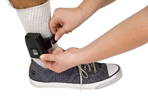
4.4 Fitting a tag 29
4.5 Support for wearers 31
4.6 Partnership working 32
5. GPS and offender management 34
5.1 Role of GPS monitoring in offender management 34
5.2 Perceived benefits for offender management 34
5.3 Perceived barriers to offender management 35
5.4 Compliance with the GPS tag 375.5 Non-compliance and breaching 38
5.6 Alternatives had GPS location monitoring not been in place 42
6. Wider impacts of GPS location monitoring 44
6.1 Perceived impact on wearers 44
6.2 Perceived impact on staff and their roles 46
7. Key learning for the wider rollout of GPS location monitoring 48
7.1 Key benefits and challenges of GPS location monitoring 48
7.2 Learning points 48
References 52
Annex A: Cost evaluation findings 54
8. Summary 55
9. Approach 56
9.1 Aims and objectives of the evaluation 56
9.2 Cost capture methods 56
10. GPS pilot cost estimates 59
10.1 Headline findings 59
10.2 Costs by stakeholder 60
10.3 Estimations and assumptions 60
10.4 Sensitivity analysis 64
10.5 Caveats 67
11. Conclusion and future directions 68
Annex B: GPS pilot overview 69
Annex C: Methodology 71
Annex D: Topic guides 74
Annex E: Context and background 77
Annex F: Description of tags used in the pilot 79
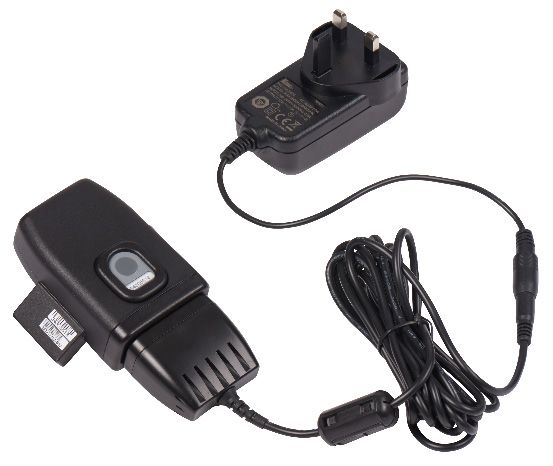
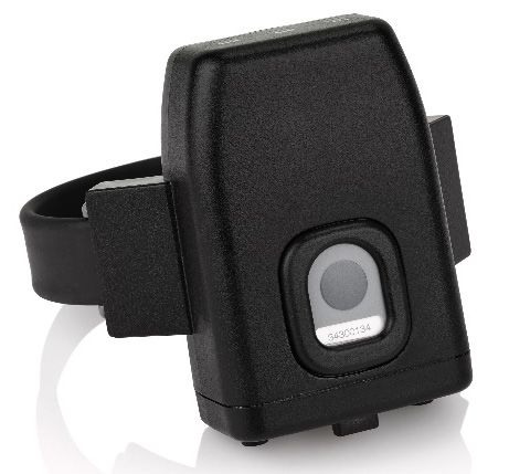
Glossary 80List of tables Table 4.1 Number of GPS tag wearers 22 Table A.1 Headline findings, GPS pilot cost capture 59 Table A.2 Additionality costs broken down by stakeholder 60 Table A.3 Estimated Absorbed Costs 61 Table A.4 Action for breaches 62 Table A.5 Impact of varying estimated costs and allowing for IOM wearers 65 Table A.6 Estimation of costs had peak throughput been maintained 66 Table B.1 Decision-making agencies for each cohort 69 Table C.1 Number of participants interviewed per participant group 71 List of figures Figure B.1 Information sharing between agencies throughout the monitoring period 70 Figure F.1 Attenti One Piece GPS Offender Tracking Device 79 Figure F.2 Tag fitted to ankle 79 Figure F.3 Mains charger connected to tag 79 Figure F.4 Portable battery powered charger 79
1.       Summary

Key findings
Eight police force areas in England were involved in a Ministry of Justice (MoJ) pilot of GPS
location monitoring between October 2016 and March 2018. This process evaluation used
qualitative methods to understand views and experiences of the implementation and delivery
of the pilot as well as perceived impacts from the perspective of strategic stakeholders,
delivery partners and GPS tag wearers. The key findings of the research are as follows.
     •   Partner agencies were enthusiastic about the prospect of using GPS location
         monitoring to help monitor and manage compliance with bail, sentence, and licence
         conditions.
     •   Clear and timely training and guidance for the staff involved in the setup and delivery
         of the pilot was highlighted as vital to effective delivery.
     •   The process of fitting tags was thought to have gone smoothly, although some
         concerns were raised in relation to the time taken to fit tags.
     •   GPS location monitoring was felt to support the effective management of offenders in
         the community and individuals on court bail in four key ways: supporting offender
         rehabilitation, facilitating risk management, informing decisions about whether a
         wearer should be recalled to custody or court, and providing evidence to either
         exonerate a wearer or link them to a crime.
     •   Key learning points include the importance of clear communication across and within
         partner agencies to enable a consistent approach to delivery, and the need for
         sufficient time and resources to develop the infrastructure to support the wider rollout
         of GPS location monitoring.

Introduction and background
This report presents the findings of the independent process evaluation of the Global
Positioning System (GPS) location monitoring pilot (GPS pilot), which used GPS tags to
remotely record information on the whereabouts of offenders and defendants within the
criminal justice system (CJS). GPS location monitoring aims to support offender
management, assist rehabilitation and introduce additional assurance to give decision
makers the confidence to impose a non-custodial outcome or order release on licence, for
individuals who would otherwise be in prison.

Eight police force areas in England (across two regional police force clusters) were involved
in an MoJ pilot of GPS location monitoring between October 2016 and March 2018. The pilot

                                                  1
covered a range of criminal justice pathways or cohorts, aiming to facilitate diversion
(including via a reduction in the use of custodial remand), as well as early release from
prison. Various conditions or restrictions could be monitored by the GPS tag, depending on
the cohort, and wearers’ and victims’ needs. These included monitoring a wearer’s location,
compliance with exclusion zones that aimed to prevent the wearer from entering an area or
address, and attendance at specific activities or appointments.
MoJ commissioned a qualitative process evaluation to explore the setup, delivery and
perceived outcomes of the pilot. Findings have implications for policy makers and staff
involved in electronic monitoring and offender management. They also offer evidence to
inform further rollout of monitoring offenders and defendants via GPS location monitoring.
Methodology
A qualitative case study design was used to obtain a comprehensive picture of the pilot in
four police force areas (across two police force clusters). Case study areas were carefully
selected to ensure diversity across: geographical size and context, pilot progress to date,
and model of delivery.1 In-depth interviews and small group discussions were undertaken
between April 2017 and February 2018, and captured the perspectives of those involved. A
total of 122 participants took part in the evaluation, including 108 strategic and operational
staff from the police, prison estate, courts system, probation service, parole, the Public
Protection Casework Section (PPCS),2 and the GPS monitoring centre.3 Fourteen individuals
across different wearer cohorts4 were interviewed to explore their views and experiences of
location monitoring.
Key findings
Early views and expectations of GPS location monitoring
Participants were enthusiastic about the potential of the GPS tag to help monitor and
manage compliance with bail, sentence and licence conditions. It was expected that location
1 Data was also collected from participants outside of the four case study areas where it was felt that this would
help to address the evaluation’s aims and objectives.
2 The PPCS is responsible for revoking prison licences following a breach of conditions, issuing recalls to
custody, and varying licence conditions.
3 A monitoring centre for the pilot was set up in Hertfordshire. It was operated by police staff who were
responsible for reviewing alerts generated by the tags, and for reporting any confirmed breaches to
responsible officers.
4 Five cohorts of wearers were eligible for the GPS tag when the pilot commenced. The cohorts covered a
range of offender groups as well as individuals on court-imposed bail who would otherwise have been
remanded in custody. Section 2 of this report provides further detail on the pilot cohorts.
2monitoring would offer additional assurance to CJS partners who may not have otherwise
been released, to manage individuals in the community, to relieve pressures on other
rehabilitative services, encourage desistence, and offer potential safeguarding for victims.
Pilot setup
Setting up the GPS pilot involved implementing necessary infrastructure, systems and
processes for delivery. This included: staffing a strategic team in HM Prison and Probation
Service headquarters and a police project manager in each cluster to oversee delivery,
setting up the monitoring centre to review data generated by tags, and liaising with staff in
the CJS and field teams to fit and remove tags.
The importance of clear and timely information, training and guidance was highlighted as
vital to ensuring the pilot could be delivered effectively. A range of training sessions and
guidance materials were produced including the pilot toolkit, awareness sessions and
practical training to support specific parts of the process (such as tag fitting). Overall, staff
spoke positively of the training and guidance, but some concerns were raised over the
accessibility and timeliness of what was provided. In response to this and over time,
additional resources were made available.
Uptake of the GPS tag
In total, 586 individuals were tagged, with uptake increasing over the course of the pilot. The
GPS tag was considered appropriate for individuals who would benefit from their
whereabouts being monitored, to deter them from certain areas and/or individuals, and
provide evidence if they did not comply with conditions set. This included a range of different
contexts, including where individuals were suspected of or had been involved in violent
offences (including domestic violence), harassment, gang crime, football related offences,
and theft, in cases where individuals had been convicted multiple times.
A range of agencies were involved in decisions about whether and how to impose GPS tags.
They considered factors such as individual risk levels, previous offending, motivation to
change, ability to manage the GPS tag and other sentence requirements. Decision making
was enabled through support from the monitoring centre and guidance such as the toolkit. In
order to recommend a GPS tag, decision makers needed a good understanding of and
confidence in the process.
Decision makers imposed a number of monitoring conditions alongside the GPS tag, which
in many cases included exclusion zones to manage where individuals went and when. While
3this was perceived to be a useful function of the tag, challenges with defining and
communicating exclusion zones were identified, which sometimes made it difficult for
wearers to understand zone boundaries and comply with licence, order or bail conditions.
Fitting the GPS tag
The process of fitting tags was thought to have gone smoothly and wearers reported being
given useful information to help them understand how the tag would work. However,
concerns were raised by some within the judiciary and field team about the length of time
between the decision being made to fit a tag and the tag actually being fitted, (which could be
up to 24 hours) as this was felt to increase the risk of reoffending and of harm to victims.
GPS location monitoring and offender management
GPS location monitoring was felt to support the effective management of offenders in the
community and individuals on court bail in four key ways:
• supporting offender rehabilitation
• facilitating risk management
• helping to inform decisions about whether a wearer should be recalled to custody or
court
• providing evidence to either exonerate a wearer or link them to a crime
Alongside these benefits, challenges in monitoring and managing wearers were identified.
These included perceived gaps in the infrastructure and staffing required to run the pilot.
There were also concerns about information sharing processes.
Levels of compliance were generally thought to be good. Ongoing support provided by the
field teams, monitoring centre and probation was considered essential in giving wearers the
best chance of complying with the requirements or conditions of their GPS tag. The tag itself
was also regarded as important, as it acted as a physical reminder of the need to comply
with requirements. Instances of unintentional and intentional non-compliance or breach were,
however, reported. Some wearers said they found it hard to comply due to a lack of clarity
over requirements and their ability to meet them.
The monitoring centre received alerts for all instances of non-compliance and investigated
each to validate. Confirmed breaches were passed to the responsible officer. Issues of non-
compliance deemed to be more serious elicited a more serious and quicker response.
4Responses were informed by a range of intelligence on wearers, and discretion in handling
non-compliance was considered vital to effective offender management.
GPS location monitoring as an alternative to custody
GPS location monitoring gave decision makers confidence that some individuals could be
more safely managed in the community than in custody. However, it was thought that some
individuals might have been effectively managed in the community without a GPS tag,
including for less serious offences or where risks were assessed as lower.
Wider outcomes of the GPS tag
The GPS tag was thought to provide wearers with a freedom to live in the community that
they may not otherwise have been granted. It also helped them preserve family links and find
or maintain employment. Negative impacts of the GPS tag related to it having an adverse
effect on health and wellbeing. For example, some wearers reported increased anxiety about
breaching conditions or sleeplessness connected with the large size and weight of the tag.
GPS location monitoring had the potential to reduce staff time and resources spent
managing individuals in the community. For example, it was reported that curfews previously
monitored in person could be remotely monitored by responsible officers. In contrast, the
pilot was also perceived to have had a negative impact on some staff roles, including in
courts, where participants reported that discussions over conditions took longer than the
usual time allocated for bail cases.
Learning from the GPS pilot
Overall, participants were positive about the potential for GPS location monitoring and
thought that it provided the CJS with another way to manage and monitor risk within the
community. Learning points to be considered at wider rollout included the need for:
• Clear and timely communication across and within partner agencies to help
increase awareness, knowledge and embed this form of monitoring across the CJS.
The need for clear communication with wearers, around the conditions and
requirements of a tag in particular, was also thought to underpin successful delivery.
• A consistent and well-informed approach across agencies supported by the use
of standardised guidance on processes and areas of responsibility. This should be
balanced with the need for a degree of discretion to allow decision makers to
manage offenders’ behaviour and risk in a way they see fit.
5• Equipment that enables offenders to engage more easily and positively in their
rehabilitation, by minimising discomfort and the need for lengthy and regular
charging.
• Sufficient time and resources to develop appropriate infrastructure to support the
rollout of GPS location monitoring. Partners across the CJS should have the means
to collaborate on key issues throughout the rollout, and ensure that resources are
allocated effectively in order to sustain GPS location monitoring in the long term.
62. Context and approach
This report presents the findings of the independent process evaluation of the GPS location
monitoring pilot which operated in eight police force areas between October 2016 and March
2018. This section briefly sets out the research and policy context, an overview of the pilot,
the aims and objectives of the evaluation, and the evaluation methodology.
2.1 Policy and research background
Electronic tags are fitted around an individual’s ankle. They use radio frequency (RF)
technology to monitor offenders’ compliance with a curfew, and have been used within the
CJS in England and Wales in various forms since 1988 (Mair and Nellis, 2013).
GPS location monitoring differs to curfew monitoring in that the tag remotely captures and
records information on an individual’s whereabouts at all times, rather than only confirming
whether individuals are at a particular address at a particular time. The tag receives location
signals from satellites and then communicates location data via a mobile phone network to a
case management system. Location monitoring via GPS tagging in the current pilot was
intended to support offender management, assist rehabilitation and introduce additional
assurance that may give decision makers confidence to impose a non-custodial outcome for
some offenders and defendants who would otherwise be in prison.
GPS location monitoring has been used prior to the current pilot. Between 2004 and 2006,
GPS tags were piloted by the Home Office in Greater Manchester, Hampshire and the West
Midlands, primarily with prolific and other priority offenders (Shute, 2007). Since then only a
small number of subjects have had a GPS tag imposed as part of an order or prison licence,
partly due to the limited availability of such tags. GPS tags have also been used in a small
number of cases by some police forces, usually with offenders on Integrated Offender
Management (IOM) schemes (Hudson and Jones, 2016). These schemes differ from the
current pilot in that they are voluntary. The pilot therefore represents the first large-scale use
of compulsory GPS location monitoring in England and Wales.
Evidence on the impact of GPS location monitoring, and electronic monitoring in general, is
limited. Meta-analyses have found that electronic monitoring has no significant impact on
reoffending, although some studies have reported benefits when it has been integrated with
other supporting interventions (Belur et al., 2017). Much of this evidence is from the United
States and findings may not be applicable to England and Wales. It was beyond the scope of
this study to carry out an evidence review. However, two recent systematic reviews provide a
7useful overview of the international literature on electronic monitoring (Belur et al., 2017,
Graham and McIvor, 2015).
2.2 Pilot overview
The pilot ran for 18 months across two regional police force clusters between October 2016
and March 2018. 5 Eight police force areas were covered:
• Leicestershire
• Nottinghamshire
• Staffordshire
• West Midlands
in the Midlands cluster, and:
• Bedfordshire
• Northamptonshire
• Cambridgeshire
• Hertfordshire
in the BeNCH cluster.
The areas were chosen to ensure sufficient volumes of referrals to the pilot and to include
both urban and rural areas. A total of 600 tags were made available across the two pilot
clusters and a project manager responsible for the operational delivery of the pilot was
appointed to both. The intention was to learn from the pilot before rolling out GPS location
monitoring nationally (National Offender Management Service (NOMS), 2016). 6
Cohorts
Five separate cohorts of wearers were eligible for the GPS tag when the pilot commenced.
The cohorts covered a range of offender groups as well as individuals on court-imposed bail
who would otherwise have been remanded in custody. Additional detail about the five
cohorts is provided in Annex B. 7 For most cohorts, location monitoring was intended to
provide an alternative to custody.
1. Individuals on court-imposed bail, who would otherwise be remanded in custody.
5 Seven areas went live in October 2016 and the final area went live in March 2017.
6 It was not an aim of the evaluation to investigate the tagging technology itself or how it worked beyond any
behavioural change it may have encouraged.
7 An additional cohort of offenders subject to Integrated Offender Management (IOM) on automatic release from
prison was introduced to the pilot in October 2017. However, they were not included in this evaluation.
82. Offenders given suspended sentence orders (SSO 8) or community orders
(CO 9), who would otherwise have been given a short custodial sentence.
3. Offenders released on Home Detention Curfew. 10 HDC boards were able to
impose a GPS tag for prisoners eligible for HDC and where it was felt that risks
could be managed more effectively by a GPS tag than a Radio Frequency (RF) tag.
4. Case managers from the National Probation Service (NPS) or Community
Rehabilitation Companies (CRCs) could recommend a GPS tag for offenders who
were not complying with their licence conditions and where enforcement action was
being considered (licence variation) and for offenders who were being considered
for re-release from prison after recall.
5. Offenders in prison on a life sentence or Imprisonment for Public Protection
(IPP 11), where the Parole Board had the option to impose a tag as a release
condition. For the pilot, it was envisaged that GPS location monitoring would be an
additional option for the Parole Board that may enable the release of offenders who
otherwise would not have been considered.
GPS tags and monitoring
A recommendation for a GPS tag could come from an offender’s existing offender manager,
a National Probation Service (NPS) offender manager in court, police, the Crown
Prosecution Service (CPS) or Parole Board. Agencies with overall responsibility for the
decision whether to use a tag or not varied according to the wearer cohort and included the
judiciary, a releasing prison’s Home Detention Curfew (HDC) board, Public Protection
Casework Section (PPCS), 12 the Parole Board and probation. Additional detail on the
agencies involved across the wearer cohorts is provided in Annex B.
A single monitoring centre for the pilot was set-up in Hertfordshire. The monitoring centre
was operational for 24 hours a day and was run by police staff responsible for reviewing
8 Short custodial sentences may be suspended for up to two years. This means that the offender does not go to
prison but is instead given the chance to live in the community and comply with up to 13 requirements set by
the court.
9 COs require offenders to carry out activities in the community as part of their sentence plan. Wearers within
this cohort would not have necessarily been given a custodial sentence if GPS monitoring had not been
available. CO requirements must be deemed suitable and commensurate with the seriousness of an offence
(Section 148 CJA 2003).
10 HDCs allow offenders to be released from prison earlier than their release date on licence in the community.
11 IPP sentences are indeterminate sentences designed to protect the public from serious offenders whose
crimes did not merit a life sentence. After offenders have completed a ‘minimum tariff’ or number of years in
custody they can apply to the Parole Board for release. If released they will be on a supervised licence for at
least 10 years. IPP sentences were discontinued in 2012.
12 The PPCS is responsible for revoking prison licences following a breach of conditions, issuing recalls to
custody, and varying licence conditions.
9alerts generated by tags. They would then report any confirmed breaches within 20 minutes
to responsible officers (who included police, NPS and CRC staff), who would consider what
action to take. Responses to alerts varied according to the cohort of the wearer and the
severity of the non-compliance. 13 As well as the ankle tag, supplementary equipment was
provided, including a stationary home beacon that was installed in the wearer’s approved
address, and two chargers (one portable and one stationary) to be used daily to ensure tags
remained charged. Annex F provides further information about the equipment.
Monitoring conditions
Various conditions or restrictions could be monitored by the tag, depending on cohort: 14
• exclusion zones which aimed to keep the wearer from entering an area or address
• attendance at a particular activity or appointment, such as a community offending
behaviour programme
• standalone monitoring15 which involved the monitoring of the wearer’s location.
This data was viewed retrospectively by responsible officers
• curfews 16 which aimed to confine the wearer to their home during specified hours
GPS monitoring data
MoJ issued a Code of Practice, setting out guidelines relating to the processing of data
gathered via electronic monitoring. 17 Accordingly, the monitoring centre was required to only
monitor a subject’s compliance with requirements of the order and not to access extraneous
data without a lawful reason. The document also explained that wearers would receive a Fair
Processing Notice, to explain the purpose and use of data collected, and that data would be
shared with Criminal Justice Agencies ‘where necessary and proportionate to do so’. Apart
from the monitoring centre and MoJ, responsible officers were to be securely given
information to help monitor compliance within their own particular area of responsibility.
For example, the Code of Practice explained that NPS staff would be given access to
13 The Ministry of Justice developed detailed process maps for each cohort that outline the processes to deal
with various types of non-compliance. These are available at:
https://www.gov.uk/government/publications/electronic-monitoring-global-positioning-system
14 For individuals on prison licence, legislation permits a location monitoring requirement to be imposed either as
a condition in its own right or as a condition to monitor compliance with another requirement of the licence,
such as an exclusion zone. For community sentences, legislation was commenced in the pilot areas to allow
for location monitoring to be imposed as a requirement in its own right. Legislation already permitted electronic
monitoring to be used to monitor another requirement imposed on the order. For Court Bail, location
monitoring can only be imposed to monitor compliance with another requirement of the Order.
15 Standalone monitoring was not available for court-imposed bail cases.
16 Curfews were added in May 2017 and can only be used if at least one of the other four conditions is imposed.
17 The MoJ Code of Practice for electric monitoring data can be accessed here:
https://assets.publishing.service.gov.uk/government/uploads/system/uploads/attachment_data/file/563630/An
nex_J_-_Code_of_Practice.pdf
10electronic monitoring data on orders and licences where they were acting as the responsible
officer.
Responsible officers could also request routine retrospective data for orders that they
managed. Again, this was limited to information considered necessary for the managing of
offenders or defendants. To ensure processing was compliant with data protection principles,
if a responsible officer or other stakeholder required access to data that they had a legitimate
need for and would not otherwise routinely be given access to, they had to submit an
external agency request (EAR). 18 Each case was considered individually.
2.3 Evaluation aims and objectives
NatCen Social Research (NatCen) was commissioned by the MoJ to carry out a process
evaluation of the GPS location monitoring pilot to inform wider rollout. The evaluation aimed
to understand views and experiences of the implementation and delivery of the GPS pilot as
well as perceived impacts from the perspective of strategic stakeholders, delivery partners,
GPS tag wearers and victims.
The study did not seek to identify the impact of the GPS location monitoring pilot. Instead,
the specific objectives of the research were to:
• describe the implementation of GPS location monitoring for offender management
• understand how decisions to use GPS location monitoring were taken
• identify factors affecting successful implementation of GPS location monitoring
• describe the perceived impacts of GPS location monitoring on wearers, offender
management and the wider CJS
A further aim of the evaluation was to provide an estimation of the resource implications of
running the GPS pilot and the time and costs involved. This work was conducted by
Manchester Metropolitan University (MMU) and further detail on the aims, approach and
findings is included in Annex A.
18 More information and brief guidance on EARs can be found here:
https://www.gov.uk/government/uploads/system/uploads/attachment_data/file/591843/Annex_Q_EAR_Guidan
ce_and_request_from.docx
112.4 Methodology
The NatCen process evaluation involved two phases of data collection: scoping work and
qualitative case studies. Further detail on both phases is provided below.
The scoping phase was carried out between October 2016 and March 2017 and aimed to
provide the research team with a thorough understanding of contextual issues relating to the
pilot and different participant groups. It involved a review of key documents about: the setup
and implementation of the pilot, desk-based scoping on the pilot areas, three stakeholder
workshops, and three in-depth interviews with key members of staff. Findings from the
scoping phase were used to inform the research design of the mainstage fieldwork.
Qualitative case study fieldwork took place between April 2017 and February 2018 and
involved in-depth interviews in four of the eight police force areas. 19 These case study areas
were carefully selected on the basis of: geographical size and context, pilot progress to date,
model of delivery, and existence of Approved Premises. 20 Some data was collected from
participants outside of the four case study areas where it was felt that this would help to
address the evaluation’s aims and objectives. For example, due to their integral role in the
pilot, field staff were interviewed across the eight police force areas and wearers from
outside the case study areas were also included.
Interviews and small group discussions involving between two and six participants were
carried out with a broad range of stakeholders, staff and decision makers identified in the
scoping phase as playing a role in pilot implementation and/or delivery. They focused on
participants’ views and experiences of pilot setup and delivery, and perceived impacts and
outcomes of the pilot. Fourteen GPS tag wearers 21 were also interviewed about their
understanding of how the tag worked, and experiences and impacts of wearing the tag.
In total, 75 encounters with 122 participants were completed across this strand of the
evaluation. A breakdown of interviews by participant group and further details about the
methodology, including sampling, recruitment, interviewing and analysis is provided in
Annex C.
19 These were Nottinghamshire and West Midlands from the Midlands cluster, and Northamptonshire and
Cambridgeshire from the BeNCH cluster.
20 Approved Premises provide supervision and accommodation in the community to offenders, ex-offenders and
defendants. They are run by voluntary organisations or the NPS.
21 We use the term ‘wearer’ to refer to all individuals who have had experience of wearing a GPS tag on the pilot.
The term ‘offender’ is not used as some individuals given a tag may have not been convicted of an offence
(i.e. the court imposed bail cohort).
122.5 Methodological considerations
A key aim of this process evaluation was to comprehensively represent the views of a broad
range of individuals. Verbatim quotations and examples from the interviews are used
throughout to illustrate the findings. The study was robust in terms of the sampling, data
collection and analysis, and this report provides an accurate account of the data collected.
As is the case with all qualitative research, the evaluation did not aim to quantify the
prevalence of particular views and experiences. Instead the robust qualitative methodology
used for this study captured information from a range of different perspectives.
As with all research, the methodology had limitations, and it is a marker of high quality
research to acknowledge them. In addition to some changes to the GPS tagging policy, the
main methodological challenge associated with this study involved the recruitment of
participants. 22
It was our intention to carry out up to 22 interviews with tag wearers. Different attempts were
made to contact and encourage wearers to participate, but recruitment was challenging.
Interviews were carried out with 14 individuals in different cohorts, providing useful insight on
their views and experiences. It is possible that the evaluation did not capture the full range of
experiences of all tag wearers.
Recruitment of staff was also challenging. Participants stated that busy schedules and a lack
of direct involvement in pilot delivery made it difficult to take part. Flexibility in the timing and
mode of interviews and a joint letter of support from MoJ, CPS and HM Courts and Tribunals
Service helped facilitate staff recruitment by providing additional information and assurance
about the study.
2.6 Report outline
The structure of the report is as follows:
• section 3 explores the setup of the GPS location monitoring pilot
• section 4 examines the delivery of the GPS location monitoring pilot, including
facilitators and barriers
• section 5 explores the role of GPS location monitoring in the management of
wearers across the eligible cohorts
22 More detailed information on the methodological challenges encountered is described in Annex C.
13• section 6 explores the perceived outcomes of the GPS location monitoring pilot on
wearers, staff across the CJS, and on offender and risk management more widely
• section 7 sets out the report’s conclusions and recommendations
143. Setting up the GPS pilot
This section explores how the GPS pilot was set up from the perspective of strategic and
operational staff including views on infrastructure, delivery processes and the usefulness of
training. It also explores early perceptions of GPS location monitoring.
3.1 Pilot overview
Eight police forces were selected to participate in two pilot areas (the BeNCH and Midlands
clusters) to generate a sufficient number of referrals and to include both urban and rural
areas. Other reasons included previous experience of the use of GPS location monitoring on
a voluntary basis with wearers, and the potential for effective partnership working between
police forces and CJS partners within each cluster. Previous experience of working together
was felt to have facilitated setup.
“Most police forces have good relationships with their criminal justice partners … but
where there were stronger relationships, they generally had better systems in place to
kind of join up and have good local working relationships on a regular basis, largely
through criminal justice boards, or … those types of meetings.” Staff participant,
police
To ensure GPS location monitoring could be widely tested, a decision was taken to include
additional cohorts across the pilot areas, which included prisoner wearer cohorts in the
Midlands cluster and extending eligibility to an IOM cohort. 23 It was hoped that this would
increase uptake, and expand understanding of how GPS location monitoring might be used
and the overall value of the intervention with a range of cohorts and in different settings.
3.2 Eligibility criteria
The pilot guidance stated that GPS location monitoring could be used in the following
circumstances if subjects:
• lived in one of the two geographical areas (BeNCH or Midlands)
• were over the age of 18
• fell into one of the five cohorts detailed in 2.2 (cohorts include court imposed bail,
SSOs and COs, HDC, licence variation and Parole Board cases)
23 GPS location monitoring was introduced for an additional cohort of offenders who were subject to IOM on
automatic release from prison from October 2017 onwards. However, this group was outside the scope for the
pilot and were not included in this evaluation.
15In addition, the guidance indicated that GPS tags should not be used with individuals who did
not have a fixed abode or who had ‘serious identified mental health or learning disabilities’.
These factors were regarded as potentially detrimental to a wearer’s ability to comply with
conditions.
Staff described some confusion over eligibility criteria at the beginning of the pilot. For
example, some were unsure of the exact geographical areas within scope and how the tag
should be used alongside other conditions of the order. Furthermore, staff from one prison
described how they had initially thought that they should release all offenders on HDC with a
GPS tag including those who would have been released anyway without one, 24 rather than
only using tagging as a direct alternative to keeping an offender in custody.
Staff were keen to consider how eligibility could be further extended 25 and identified other
groups that they felt could be usefully monitored using the GPS tag. Suggestions included
the following.
• Cases that would otherwise be managed in the community without a GPS
tag, 26 including lower level anti-social behaviour. In these cases location monitoring
would be used to improve offender management but not as an alternative to custody.
• Young people who would otherwise be held in secure accommodation for
public protection. However, an alternative view among the judiciary was that a GPS
tag was less suitable for young people, who may find it difficult to understand how
the tag works.
• Individuals with no fixed or ‘appropriate’ address. One view within the CRC was
that the requirement of a fixed address was a barrier to using the tag as a proportion
of the individuals they managed did not have a fixed address or appropriate
accommodation. 27 While it was hoped there might be opportunities in the future to
include individuals with no fixed abode, it was noted that a number of practical issues
such as access to charging the tag would need to be overcome.
24 Standard HDC releases use a Radio Frequency (RF) tag to monitor a curfew.
25 As described in sections 2 and 3, the eligibility criteria for the pilot had already been extended to include IOM
offenders on automatic release.
26 As described in section 2.2, GPS location monitoring was intended as an alternative to custody for most
cohorts, although in a minority of cases this was not the intent (such as IOM cases).
27 Subjects of ‘no fixed abode’ were ineligible for GPS tags as per the pilot guidance. However, tagged subjects
could reside at Bail Accommodation Support Services (BASS) or Approved Premises and were not prevented
from moving accommodation (providing this was supported by their responsible officer).
163.3 Timeframes
Pilot areas were given nine months to set up the pilot, which was launched in October 2016
and ran for 18 months to March 2018, when the final tags were removed. Staff said that they
found setup timeframes challenging as they were asked to prepare for launching it more
quickly than originally anticipated. One police force started delivering the pilot later than
intended (in March 2017 rather than October 2016). A range of reasons were given for this,
including difficulties engaging key staff and a recent restructure of the police force in this
area. As outlined later in this section, timeframes had an impact on how quickly and
effectively agencies were able to deliver pilot activities in the early phases of the pilot.
3.4 Infrastructure and resources
Setting up the pilot involved a significant amount of work. This included recruiting a
commercial contractor to provide the tags and software, setting up an operational monitoring
centre and staffing the field teams. A team was also appointed within MoJ and HM Prison
and Probation Service (HMPPS) who had responsibility for scoping, designing and managing
the pilot and providing support to the pilot areas and agencies.28 Working alongside this
team, the pilot was overseen by a programme director and a police project lead within each
cluster. These were dedicated roles for the duration of the pilot, and their responsibilities
included: managing the funding provided by MoJ for police forces to deliver the pilot,
developing the relevant policy and processes for the pilot, and management of the field
teams. The project leads also served as a central point of contact between the police, CJS
partners and the MoJ, and were thought to be an important source of information and
coordination.
Field teams were recruited for each police force area to fit and remove the tags and, where
necessary, deal with any issues arising for wearers, including faulty equipment and strap
tampers. In both clusters, field teams were recruited from non-police backgrounds, but in the
Midlands, roles were also taken on by police staff. These field team officers therefore had
additional powers to breach wearers and could access data from the Police National
Computer database. Participants reported that these additional capabilities were useful in
managing wearers. However, the speed at which some field staff had been recruited,
especially from IOM teams, led to concerns about the readiness of field teams to deliver at
the point the pilot went live.
28 This included engaging eight police forces in the pilot, developing the underpinning polices and processes and
designing and delivering communication and training sessions. Additional detail on their role is provided in
Annex E.
173.5 Communication, guidance and training
Communication
The importance of clear and timely information about the nature of the pilot was highlighted
as a key part of the setup stage, especially as GPS location monitoring was a new approach
to many of the staff involved. However, some participants felt restricted by the extent to
which they were able to share information across the CJS. This was described in two ways.
Firstly, concerns were highlighted by some participants about restrictions placed on more
public-facing communications, such as with the media. This perception was thought to have
prohibited more open forms of communication and was especially felt by partners sitting
outside of MoJ such as the police and judiciary, who reported that it had had a negative
impact on their awareness of the pilot early on.
Secondly, the onus was placed on strategic leads and staff to cascade information across
and within relevant agencies. This meant that some information did not get to the right
agencies or individuals in order to facilitate preparation for the pilot. While this method of
cascading information was valued (and was perceived to have improved over time), there
was a concern among some that the process might have been too piecemeal to deliver
timely and consistent messaging.
Communication was also found to be challenging given the disparate nature of some key
stakeholders such as magistrates. More open and timely communication targeted at pilot
areas would have been welcomed to facilitate early awareness and information sharing
across stakeholders. Participants said this may have helped partners feel engaged and
consulted from the outset, and would have encouraged greater commitment to the pilot.
Guidance and training
Part of the setup stage involved providing guidance around how the pilot worked and the
roles and responsibilities of key delivery partners. A toolkit was produced by the HMPPS pilot
team which detailed how the processes were supposed to work (NOMS, 2016). In addition,
other formal training, briefings and written guidance were provided by the HMPPS pilot team,
the independent tag provider and partner agencies. This included high-level training, such as
the HMPPS awareness sessions about the nature of the pilot and GPS location monitoring
technology which were delivered across the CJS. Briefing packs were also distributed to
delivery partners about GPS processes including decision making, the wording of licence
18conditions, and handling issues of non-compliance. The suite of training materials provided
by the pilot team is listed in Annex E.
Staff generally welcomed the training and guidance, and thought it was an important part of
the setup process, especially given the multi-agency nature of the pilot. However, concerns
were raised over its accessibility and timeliness. One view was that staff did not have enough
time to read the guidance provided, especially the toolkit. In response to this, additional
guidance and resources were made available, which participants found very useful. For
example, a shorter, two-page guide was issued after the pilot was launched which set out
key information and was tailored to different CJS partners. This highlights an important
flexibility in the HMPPS pilot team as they responded to feedback and provided additional
material to support understanding of GPS location monitoring over time.
More specific training was also provided to the field teams and monitoring centre staff around
systems and processes relevant to their roles. For field teams this included some standard
police training modules (for example in data protection and health and safety) and training to
fit and remove a tag. Participants highlighted the importance of practical training and being
able to put this training into practice within a reasonable timeframe. In response, a video of
the fitting process was made available so that this guidance was even clearer for staff.
“It's okay being trained in a ‘doing’ thing, but then if you don't do it ... the
expectation that you're going to suddenly do it on your own at seven o'clock at
night in some offender's house ... three months after some training, it's kind of a
bit unrealistic.” Staff participant, police
Gaps in training and knowledge
Staff participants acknowledged that, over time, it was likely the guidance and training
provided to support GPS location monitoring would improve as the programme became
embedded within the CJS. However, suggestions for specific areas where additional
guidance and training would have been useful included:
• Additional training for a wider pool of staff on how to fit tags properly and resolve any
fitting issues (such as tags being too tight). This would enable practical issues to be
dealt with quickly, including in the absence of the field team.
• Guidance on police protocols, specifically about managing personal risk for staff
visiting wearers’ homes. This would have been welcomed by field team staff from a
non-police background who recognised the potential for them to be placed in
dangerous situations.
19“I feel that we could have a bit more training … like being prepared for a situation
really because the thing is with this kind of role you just don't know what is gonna
happen … We've always been told if an offender's not happy to be tagged and
they're violent … you just leave. So you just hope that an offender would never
lock us in or you know, we can't escape or things like that.” Staff participant,
police
• Information about the type of GPS data that responsible officers could request from
the monitoring centre to support effective offender management. For example, some
staff thought that they would be able to monitor and view wearers' locations in real
time and access the data via a central IT system, which was not the case.
• Some wider partners working with both victims and wearers (for example in
Approved Premises) reported that they were not aware of the pilot until it
commenced, and would have welcomed some light-touch training in order to properly
understand the purpose of the pilot and how they might support it.
Barriers to attending training on the pilot included: partners having limited resource and time
available, not perceiving the pilot as forming a significant part of their job role, and the timing
of training sessions. For example, magistrates found it difficult to attend training scheduled
over lunchtimes. 29
3.6 Early perceptions of GPS location monitoring
Staff and stakeholders were asked to reflect on their early perceptions of the pilot, and their
expectations for managing different wearer cohorts via GPS location monitoring. They were
enthusiastic about the approach, which they hoped would expand capabilities to monitor
compliance, manage risk and, for offender cohorts, offer rehabilitative support. A number of
potential benefits were discussed.
• Additional monitoring capabilities via GPS technology which provided assurance
that relevant authorities would be alerted to non-compliance quickly.
• GPS location monitoring was generally felt to offer an alternative to custody by
enabling individuals who might otherwise be in prison, including individuals released
on parole, to live more safely and securely in the community. It therefore extends
opportunities to a wider pool of potential wearers than may have been considered for
other requirements, such as Radio Frequency tagging. The pilot was also viewed as
29 In response to feedback from magistrates, the pilot team subsequently arranged additional training sessions
which were held at the beginning and end of the day.
20an important part of a perceived wider strategy to reduce the prison population and
thus potentially save money, while effectively managing risk.
“I think … the pilot was aiming to find out whether this technology would be
favoured by the judiciary to such an extent that it could save the state money to
enable it to reduce the prison population.” Staff participant, court
• A further view was that location monitoring could relieve pressures on other
rehabilitative services. This included housing, widely acknowledged as a protective
factor from reconviction (see for example, Brunton-Smith and Hopkins, 2014). For
example, more offenders could reside safely at private addresses because of
wearing a tag, which in turn could create space in Approved Premises for other
offenders released on license.
• Potential for desistance as the tag could act as a physical reminder to wearers
about the requirements of their order and therefore reduce their risk of reoffending.
Furthermore, location information provided by the tag could help wearers counter
false allegations and, for some, support rehabilitation in the community (discussed in
section 5).
• Potential safeguarding for victims through the use of exclusion zones. Participants
reported that GPS location monitoring may help victims feel safer and limit the
likelihood of further offences being committed.
Alongside the potential benefits described, hypothetical concerns were also raised about
impacts the pilot may have on staff workloads and about how conditions would be enforced.
In addition, staff questioned whether and how potential risks to victims would be fully
considered when making decisions about order, bail or licence conditions. A view within the
judiciary was that the risk to victims could be better managed if they were given alarms which
would be triggered if a wearer removed their tag or entered their exclusion zone, though this
functionality was beyond the scope of the pilot.
214. GPS pilot delivery
This section explores delivery of the GPS pilot, including:
• the profile and types of cases considered for GPS
• the role of decision makers in using GPS location monitoring and setting bail, order
or licence conditions
• the processes involved in fitting a tag
• supervision and monitoring of wearers
• the role of partnership working in pilot delivery
4.1 GPS cases
Numbers tagged
As outlined in section 3, one of the pilot aims was to test demand for GPS location
monitoring. Prior to knowing how widely the GPS approach would be used, accurately
predicting the number of tags required for the pilot was difficult. MoJ made a total of 600 tags
available, as it was necessary to ensure a tag was fitted to every person allocated one. It
was thought that this approach would support the widest possible testing of the GPS tag in
different contexts and with different wearer cohorts, and provide important learning on the
number of tags required for national rollout. As has been experienced in other pilots and
programmes of this nature (especially in the early stages of delivery), uptake was initially low.
With the expansion of the pilot and greater awareness however uptake subsequently
increased, and at the end of the pilot 586 individuals had been tagged, as shown in
Table 4.1. 30
Table 4.1 Number of GPS tag wearers 31
Wearer cohort Number of tags
Court imposed bail 220
Community orders 17
Suspended sentence orders 7
Home Detention Curfew 87
Release after recall 113
30 As described in sections 2 and 3, the IOM cohort became eligible for the GPS pilot partway through the pilot.
Although not included in the evaluation and the numbers reported here, the inclusion of the IOM cohort meant
that in total 684 individuals were tagged by the end of the pilot. The number of wearers may have been higher
if the rate of uptake at the end of the pilot had been maintained throughout. If this had been the case, MoJ
predicted that the total number of tags fitted may have been closer to 1,500.
31 Data collected by the monitoring centre.
22Wearer cohort Number of tags
Licence variation 60
Parole Board 82
Total 586
This table highlights variation in the numbers of wearers in each cohort. 32 Participants
thought this variation might be linked to the extent to which different partner agencies
responsible for recommending a tag were aware of and had embedded the pilot, as well as
the available pool of eligible wearers within the cohorts. Additional explanations are detailed
below.
• Numbers across cohorts may have increased due to changes to policies partway
through the pilot. These meant for example that GPS location monitoring could be
used for a curfew alongside other conditions monitored by GPS, 33 and may have
meant the tag could be deployed to support a greater range of scenarios.
• It was felt that the number of Parole Board cases may have increased due to a
proactive decision taken by the Parole Board to raise awareness of the pilot and use
systems to flag cases that might be eligible for a GPS tag among colleagues.
• The number of COs and SSOs were lower than anticipated. A suggestion for this
was that there may have been a limited pool of wearers from this cohort that the tag
could be effectively used with. For example, for COs it was felt likely that judges
would have decided that individuals did not need a custodial sentence and would
therefore need another convincing reason for using a tag.
Findings here are supported by internal work conducted by the HMPPS pilot team to improve
understanding of variation in cohort numbers. This identified a preference among sentencers
to use a curfew over a GPS tag for community orders, and a reluctance to use both together,
which may have meant that GPS location monitoring was not used as much as it could have
been for this cohort.
Types of cases monitored
Participants felt that GPS location monitoring was an appropriate option for individuals who
would benefit from continuous monitoring of their whereabouts to help deter them from
certain areas and/or individuals. Offences deemed appropriate by staff for GPS monitoring
included violent offences such as domestic violence (DV), harassment, some sex offences,
32 A level of variation was expected between cohorts and pilot areas due to differences in the eligible population.
33 This functionality was initially only available for HDC and Parole Board cases.
23You can also read