Weather Encounter and Subsequent Collision into Terrain Bali Hai Helicopter Tours, Inc. Bell 206B, N16849 Kalaheo, Hawaii September 24, 2004 ...
←
→
Page content transcription
If your browser does not render page correctly, please read the page content below
Weather Encounter and Subsequent
             Collision into Terrain
    Bali Hai Helicopter Tours, Inc.
                Bell 206B, N16849
                  Kalaheo, Hawaii
              September 24, 2004

  aviation             ACCIDENT REPORT
                           NTSB/AAR-07/03
                            PB2007-910404
this page intentionally left blank

Aircraft Accident Report
Weather Encounter and Subsequent
 Collision into Terrain
Bali Hai Helicopter Tours, Inc.
Bell 206B, N16849
Kalaheo, Hawaii
September 24, 2004

                                                                      R A N S PO
                                                                 LT
                                                          A

                                                                                           RT
                                                       NATI ON

                                                                              RI
                                                                          P LU B US UNUM
                                                                                               AT I O N
                                                                      E

                                                                                               D
                                                          SA

                                                                 FE                        R
                                                                      T Y B OA

NTSB/AAR-07/03
PB2007-910404               National Transportation Safety Board
Notation 7862A                           490 L’Enfant Plaza, S.W.
Adopted February 13, 2007                 Washington, D.C. 20594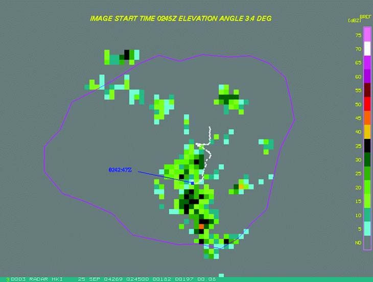
National Transportation Safety Board. 2007. Weather Encounter and Subsequent Collision into
     Terrain, Bali Hai Helicopter Tours, Inc., Bell 206B, N16849, Kalaheo, Hawaii, September 24, 2004.
     Aircraft Accident Report NTSB/AAR-07/03. Washington, DC.

     Abstract: This report explains the accident involving a Bell 206B helicopter, N16849, registered to and
     operated by Bali Hai Helicopter Tours, Inc., of Hanapepe, Hawaii, which impacted mountainous terrain in
     Kalaheo, Hawaii, on the island of Kauai, 8.4 miles northeast of Port Allen Airport, in Hanapepe. The safety
     issues discussed in this report include the influence of pilot experience and operator scheduling on in-flight
     decision-making; the lack of Federal Aviation Administration (FAA) oversight of 14 Code of Federal
     Regulations Part 91 air tour operators; the need for national air tour safety standards; and the lack of direct
     FAA surveillance of commercial air tour operators in Hawaii.

The National Transportation Safety Board is an independent Federal agency dedicated to promoting aviation, railroad, highway, marine,
pipeline, and hazardous materials safety. Established in 1967, the agency is mandated by Congress through the Independent Safety Board
Act of 1974 to investigate transportation accidents, determine the probable causes of the accidents, issue safety recommendations, study
transportation safety issues, and evaluate the safety effectiveness of government agencies involved in transportation. The Safety Board
makes public its actions and decisions through accident reports, safety studies, special investigation reports, safety recommendations, and
statistical reviews.

Recent publications are available in their entirety on the Web at . Other information about available publications also
may be obtained from the Web site or by contacting:

     National Transportation Safety Board
     Records Management, CIO-40
     490 L’Enfant Plaza, S.W.
     Washington, D.C. 20594
     (800) 877-6799 or (202) 314-6551

Safety Board publications may be purchased, by individual copy or by subscription, from the National Technical Information Service. To
purchase this publication, order report number PB2007-910404 from:

     National Technical Information Service
     5285 Port Royal Road
     Springfield, Virginia 22161
     (800) 553-6847 or (703) 605-6000

The Independent Safety Board Act, as codified at 49 U.S.C. Section 1154(b), precludes the admission into evidence or use of Board reports
related to an incident or accident in a civil action for damages resulting from a matter mentioned in the report.
iii Aircraft Accident Report
Contents
Figures . . . . . . . . . . . . . . . . . . . . . . . . . . . . . . . . . . . . . . . . . . . . . . . . . . . . . . . . . . . . . . v
Abbreviations . . . . . . . . . . . . . . . . . . . . . . . . . . . . . . . . . . . . . . . . . . . . . . . . . . . . . . . vi
Executive Summary . . . . . . . . . . . . . . . . . . . . . . . . . . . . . . . . . . . . . . . . . . . . . . . . . viii
1. Factual Information . . . . . . . . . . . . . . . . . . . . . . . . . . . . . . . . . . . . . . . . . . . . . . . . . . . 1
1.1 History of Flight . . . . . . . . . . . . . . . . . . . . . . . . . . . . . . . . . . . . . . . . . . . . . . . . . . . . . . . . 1
1.2 Injuries to Persons . . . . . . . . . . . . . . . . . . . . . . . . . . . . . . . . . . . . . . . . . . . . . . . . . . . . . . 4
1.3 Damage to Helicopter . . . . . . . . . . . . . . . . . . . . . . . . . . . . . . . . . . . . . . . . . . . . . . . . . . . 4
1.4 Other Damage . . . . . . . . . . . . . . . . . . . . . . . . . . . . . . . . . . . . . . . . . . . . . . . . . . . . . . . . . 4
1.5 Personnel Information . . . . . . . . . . . . . . . . . . . . . . . . . . . . . . . . . . . . . . . . . . . . . . . . . . . 4
1.5.1 The Pilot . . . . . . . . . . . . . . . . . . . . . . . . . . . . . . . . . . . . . . . . . . . . . . . . . . . . . . . . . . 4
1.5.1.1 Flight Time and Duty Period . . . . . . . . . . . . . . . . . . . . . . . . . . . . . . . . . . . . . . . . 5
1.5.1.2 72-hour History . . . . . . . . . . . . . . . . . . . . . . . . . . . . . . . . . . . . . . . . . . . . . . . . . . . 7
1.6 Helicopter Information . . . . . . . . . . . . . . . . . . . . . . . . . . . . . . . . . . . . . . . . . . . . . . . . . . 8
1.6.1 General . . . . . . . . . . . . . . . . . . . . . . . . . . . . . . . . . . . . . . . . . . . . . . . . . . . . . . . . . . . 8
1.6.2 Maintenance Information . . . . . . . . . . . . . . . . . . . . . . . . . . . . . . . . . . . . . . . . . . . . . 8
1.7 Meteorological Information . . . . . . . . . . . . . . . . . . . . . . . . . . . . . . . . . . . . . . . . . . . . . . . 9
1.7.1 Federal Aviation Administration Weather Radar Data . . . . . . . . . . . . . . . . . . . . . . . 9
1.7.2 Airmen’s Advisories and Area Forecast . . . . . . . . . . . . . . . . . . . . . . . . . . . . . . . . . 12
1.7.3 Witness Weather Observations . . . . . . . . . . . . . . . . . . . . . . . . . . . . . . . . . . . . . . . . 12
1.7.4 Local Weather Information Sources . . . . . . . . . . . . . . . . . . . . . . . . . . . . . . . . . . . . 13
1.7.5 Hawaii-Specific Weather Challenges . . . . . . . . . . . . . . . . . . . . . . . . . . . . . . . . . . . 13
1.8 Aids to Navigation . . . . . . . . . . . . . . . . . . . . . . . . . . . . . . . . . . . . . . . . . . . . . . . . . . . . . 14
1.9 Communications . . . . . . . . . . . . . . . . . . . . . . . . . . . . . . . . . . . . . . . . . . . . . . . . . . . . . . 14
1.10 Airport Information . . . . . . . . . . . . . . . . . . . . . . . . . . . . . . . . . . . . . . . . . . . . . . . . . . . . 14
1.11 Flight Recorders . . . . . . . . . . . . . . . . . . . . . . . . . . . . . . . . . . . . . . . . . . . . . . . . . . . . . . . 15
1.12 Wreckage and Impact Information . . . . . . . . . . . . . . . . . . . . . . . . . . . . . . . . . . . . . . . . 15
1.13 Medical and Pathological Information . . . . . . . . . . . . . . . . . . . . . . . . . . . . . . . . . . . . . 16
1.14 Fire . . . . . . . . . . . . . . . . . . . . . . . . . . . . . . . . . . . . . . . . . . . . . . . . . . . . . . . . . . . . . . . . . 16
1.15 Survival Aspects . . . . . . . . . . . . . . . . . . . . . . . . . . . . . . . . . . . . . . . . . . . . . . . . . . . . . . 16
1.16 Tests and Research . . . . . . . . . . . . . . . . . . . . . . . . . . . . . . . . . . . . . . . . . . . . . . . . . . . . . 16
1.17 Organizational and Management Information . . . . . . . . . . . . . . . . . . . . . . . . . . . . . . . . 17
1.17.1 General . . . . . . . . . . . . . . . . . . . . . . . . . . . . . . . . . . . . . . . . . . . . . . . . . . . . . . . . . . 17
1.17.2 Pilot Training . . . . . . . . . . . . . . . . . . . . . . . . . . . . . . . . . . . . . . . . . . . . . . . . . . . . . . 17
1.17.3 Pilot-Scheduling Practices . . . . . . . . . . . . . . . . . . . . . . . . . . . . . . . . . . . . . . . . . . . . 18
1.17.3.1 Daily Tour Schedules . . . . . . . . . . . . . . . . . . . . . . . . . . . . . . . . . . . . . . . . . . . . . 18
1.17.3.2 Pilot Lunch and Rest Breaks . . . . . . . . . . . . . . . . . . . . . . . . . . . . . . . . . . . . . . . . 19
1.17.4 Weather-Related Tour Cancellations . . . . . . . . . . . . . . . . . . . . . . . . . . . . . . . . . . . 19
1.17.5 Ridge-Crossing Practices . . . . . . . . . . . . . . . . . . . . . . . . . . . . . . . . . . . . . . . . . . . . 20
1.17.6 Federal Aviation Administration Surveillance – Honolulu
Flight Standards District Office . . . . . . . . . . . . . . . . . . . . . . . . . . . . . . . . . . . . . . . . . . . . 21Contents iv Aircraft Accident Report
1.17.6.1 Staffing Levels . . . . . . . . . . . . . . . . . . . . . . . . . . . . . . . . . . . . . . . . . . . . . . . . . . 22
1.17.6.2 Geographical Surveillance Unit . . . . . . . . . . . . . . . . . . . . . . . . . . . . . . . . . . . . . 23
1.18 Additional Information . . . . . . . . . . . . . . . . . . . . . . . . . . . . . . . . . . . . . . . . . . . . . . . . . 24
1.18.1 Helicopter Operations in Reduced Visibility . . . . . . . . . . . . . . . . . . . . . . . . . . . . . 24
1.18.2 Spatial Disorientation . . . . . . . . . . . . . . . . . . . . . . . . . . . . . . . . . . . . . . . . . . . . . . . 25
1.18.3 Helicopter Pilot Fatigue Issues . . . . . . . . . . . . . . . . . . . . . . . . . . . . . . . . . . . . . . . . 26
1.18.4 Flight Time and Duty Period Limitations . . . . . . . . . . . . . . . . . . . . . . . . . . . . . . . . 26
1.18.5 Special Federal Aviation Regulation 71 . . . . . . . . . . . . . . . . . . . . . . . . . . . . . . . . . 27
1.18.5.1 Certificate of Waiver or Authorization to Deviate from
Special Federal Aviation Regulation 71 . . . . . . . . . . . . . . . . . . . . . . . . . . . . . . . . . . . . 28
1.18.5.2 Formal Air Tour Safety Meetings . . . . . . . . . . . . . . . . . . . . . . . . . . . . . . . . . . . . 29
1.18.6 Automatic Dependent Surveillance-Broadcast Program . . . . . . . . . . . . . . . . . . . . . 30
1.18.7 Previous Related Safety Recommendations . . . . . . . . . . . . . . . . . . . . . . . . . . . . . . 31
1.18.8 National Air Tour Safety Standards . . . . . . . . . . . . . . . . . . . . . . . . . . . . . . . . . . . . 34
1.18.8.1 Notice of Proposed Rulemaking . . . . . . . . . . . . . . . . . . . . . . . . . . . . . . . . . . . . . 34
1.18.8.2 Final Rule . . . . . . . . . . . . . . . . . . . . . . . . . . . . . . . . . . . . . . . . . . . . . . . . . . . . . . 35
1.18.9 Requirements for Part 135 Air Tour Operators . . . . . . . . . . . . . . . . . . . . . . . . . . . . 35
2. Analysis . . . . . . . . . . . . . . . . . . . . . . . . . . . . . . . . . . . . . . . . . . . . . . . . . . . . . . . . . . . . 36
2.1 General . . . . . . . . . . . . . . . . . . . . . . . . . . . . . . . . . . . . . . . . . . . . . . . . . . . . . . . . . . . . . . 36
2.2 Accident Sequence . . . . . . . . . . . . . . . . . . . . . . . . . . . . . . . . . . . . . . . . . . . . . . . . . . . . . 36
2.3 Human Performance . . . . . . . . . . . . . . . . . . . . . . . . . . . . . . . . . . . . . . . . . . . . . . . . . . . 37
2.3.1 Spatial Disorientation . . . . . . . . . . . . . . . . . . . . . . . . . . . . . . . . . . . . . . . . . . . . . . . 37
2.3.2 Pilot’s Decision-making . . . . . . . . . . . . . . . . . . . . . . . . . . . . . . . . . . . . . . . . . . . . . 38
2.3.2.1 Inexperience with Local Weather Patterns . . . . . . . . . . . . . . . . . . . . . . . . . . . . 38
2.3.2.2 Overconfidence and Decision Bias . . . . . . . . . . . . . . . . . . . . . . . . . . . . . . . . . . . 40
2.3.2.3 Bali Hai’s Pilot-Scheduling Practices . . . . . . . . . . . . . . . . . . . . . . . . . . . . . . . . . 40
2.3.2.4 Management Pressure . . . . . . . . . . . . . . . . . . . . . . . . . . . . . . . . . . . . . . . . . . . . . 42
2.4 Federal Aviation Administration Surveillance . . . . . . . . . . . . . . . . . . . . . . . . . . . . . . . 42
2.4.1 Oversight of Part 91 Air Tour Operations . . . . . . . . . . . . . . . . . . . . . . . . . . . . . . . . 42
2.4.2 Honolulu Flight Standards District Office Surveillance of Bali Hai . . . . . . . . . . . 43
2.4.3 Honolulu Flight Standards District Office Staffing Issues . . . . . . . . . . . . . . . . . . . 44
2.4.4 Air Tour Safety Meeting Requirements . . . . . . . . . . . . . . . . . . . . . . . . . . . . . . . . . 45
2.5 Safety Impact of Special Federal Aviation Regulation 71 . . . . . . . . . . . . . . . . . . . . . . 46
2.6 Need for National Air Tour Safety Standards . . . . . . . . . . . . . . . . . . . . . . . . . . . . . . . . 46
2.7 Implementing Automatic Dependent Surveillance-Broadcast in Hawaii . . . . . . . . . . . 48
3. Conclusions . . . . . . . . . . . . . . . . . . . . . . . . . . . . . . . . . . . . . . . . . . . . . . . . . . . . . . . . . 50
3.1 Findings . . . . . . . . . . . . . . . . . . . . . . . . . . . . . . . . . . . . . . . . . . . . . . . . . . . . . . . . . . . . . 50
3.2 Probable Cause . . . . . . . . . . . . . . . . . . . . . . . . . . . . . . . . . . . . . . . . . . . . . . . . . . . . . . . 52
4. Safety Recommendations . . . . . . . . . . . . . . . . . . . . . . . . . . . . . . . . . . . . . . . . . . . . . 53
5. Appendixes
A: Investigation. . . . . . . . . . . . . . . . . . . . . . . . . . . . . . . . . . . . . . . . . . . . . . . . . . . . 55v Aircraft Accident Report Figures 1. Map of Kauai, showing accident site and some of Bali Hai’s site-specific locations . . . . . . . . . . . . . . . . . . . . . . . . . . . . . . . . . . . . . . . . . . . . 2 2. Radar data for the last 2 minutes of the accident flight plotted over a topographical map . . . . . . . . . . . . . . . . . . . . . . . . . . . . . . . . . . . . . . . . . . . 3 3. Weather radar at 1634 . . . . . . . . . . . . . . . . . . . . . . . . . . . . . . . . . . . . . . . . . . . . . . . . . . . . 10 4. Weather radar at 1639 . . . . . . . . . . . . . . . . . . . . . . . . . . . . . . . . . . . . . . . . . . . . . . . . . . . . 11 5. Weather radar at 1645 . . . . . . . . . . . . . . . . . . . . . . . . . . . . . . . . . . . . . . . . . . . . . . . . . . . . 11
vi                 Aircraft Accident Report

Abbreviations

  ADS-B     automatic dependent surveillance-broadcast
  agl       above ground level
  AIRMET    airmen’s meteorological information
  ASI       aviation safety inspector
  ATC       air traffic control
  ATIS      automated terminal information service
  CERAP     air route traffic control center and radar approach control
  CFR       Code of Federal Regulations
  dBZ       decibels
  DOT       Department of Transportation
  DUATS     direct user access terminal system
  FAA       Federal Aviation Administration
  FSDO      Flight Standards District Office
  FSS       flight service station
  GAATA     General Aviation and Air Taxi Activity
  GSU       geographical surveillance unit
  IFR       instrument flight rules
  IMC       instrument meteorological conditions
  IOE       initial operating experience
  LIH       Lihue Airport, Lihue, Hawaii
  LOA       letter of authorization
  McIDAS    Man computer Interactive Data Access System
  msl       mean sea level
  NOE       nap of the Earth or nape of the Earth
  NPG       National Flight Standards Work Program Guidelines
  NPRM      notice of proposed rulemaking
Abbreviations                         vii              Aircraft Accident Report

     NWS        National Weather Service
     PAK        Port Allen Airport, Hanapepe, Hawaii
     PIC        pilot-in-command
     POI        principal operations inspector
     S/N        serial number
     SIC        second-in-command
     SFAR       Special Federal Aviation Regulation
     UTC        coordinated universal time
     VFR        visual flight rules
     VMC        visual meteorological conditions
     WSR-88D    Weather Surveillance Radar-1988 Doppler
viii Aircraft Accident Report
Executive Summary
On September 24, 2004, about 1642 Hawaiian standard time, a Bell 206B
helicopter, N16849, registered to and operated by Bali Hai Helicopter Tours, Inc., of
Hanapepe, Hawaii, impacted mountainous terrain in Kalaheo, Hawaii, on the island of
Kauai, 8.4 miles northeast of Port Allen Airport, in Hanapepe. The commercial pilot and
the four passengers were killed, and the helicopter was destroyed by impact forces and
postimpact fire. The nonstop sightseeing air tour flight was operated under the provisions
of 14 Code of Federal Regulations Part 91 and visual flight rules with no flight plan filed.
Instrument meteorological conditions prevailed near the accident site.
The National Transportation Safety Board determines that the probable cause of
this accident was the pilot’s decision to continue flight under visual flight rules into an
area of turbulent, reduced visibility weather conditions, which resulted in the pilot’s
spatial disorientation and loss of control of the helicopter. Contributing to this accident
was the pilot’s inexperience in assessing local weather conditions, inadequate Federal
Aviation Administration (FAA) surveillance of Special Federal Aviation Regulation 71
operating restrictions, and the operator’s pilot-scheduling practices that likely had an
adverse impact on pilot decision-making and performance.
The safety issues discussed in this report include the influence of pilot experience
and operator scheduling on in-flight decision-making; the lack of FAA oversight of
Part 91 air tour operators; the need for national air tour safety standards; and the lack of
direct FAA surveillance of commercial air tour operators in Hawaii.
Nine safety recommendations are addressed to the FAA regarding local
weather-training programs for newly hired Hawaii air tour pilots; evaluation of
operational practices for commercial air tour helicopter pilots; Honolulu Flight Standards
District Office control of the annual safety meetings, as required under approved
certificates of waiver or authorization; evaluation of the safety impact of the altitude
restrictions in the State of Hawaii; national air tour safety standards; and the potential
benefits of automatic dependent surveillance-broadcast technology for Hawaii air tour
operators.1 Aircraft Accident Report
1. Factual Information
1.1 History of Flight
On September 24, 2004, about 1642 Hawaiian standard time,1 a Bell 206B
helicopter, N16849, registered to and operated by Bali Hai Helicopter Tours, Inc., of
Hanapepe, Hawaii, impacted mountainous terrain in Kalaheo, Hawaii, on the island of
Kauai, 8.4 miles northeast of Port Allen Airport (PAK) in Hanapepe. The commercial
pilot and the four passengers were killed, and the helicopter was destroyed by impact
forces and postimpact fire. The nonstop sightseeing air tour flight was operated under the
provisions of 14 Code of Federal Regulations (CFR) Part 912 and visual flight rules
(VFR) with no flight plan filed.3 Instrument meteorological conditions (IMC) prevailed
near the accident site.
The air tour flight was conducted under Special Federal Aviation Regulation
(SFAR) 71, “Special Operating Rules for Air Tour Operators in the State of Hawaii,” and
in accordance with a certificate of waiver or authorization approved for Bali Hai by the
Federal Aviation Administration’s (FAA) flight standards district office (FSDO) in
Honolulu, Hawaii. The minimum altitude for tour flights specified in SFAR 71 is
1,500 feet above ground level (agl) and no closer than 1,500 feet to any person or
property, unless otherwise authorized. Bali Hai’s certificate of waiver or authorization
allowed its pilots to deviate from the minimum altitude requirement and to fly transition
segments4 at 1,000 feet agl, cross ridgelines at 500 feet agl, and cross razorback
ridgelines5 at 200 feet agl.
The flight, which was the pilot’s eighth and final tour flight for the day, was
scheduled to depart PAK about 1600 and fly clockwise around the island of Kauai for a
45-minute sightseeing tour over a number of site-specific locations,6 including Waimea
Canyon, the Na Pali Coast, Waialeale Crater, and Manawaipuna Falls (see figure 1).
1
Hawaiian standard time is coordinated universal time minus 10 hours. Unless otherwise indicated, all
times are Hawaiian standard time based on a 24-hour clock.
2
According to Federal Aviation Regulations, 14 CFR Part 91 commercial air tour flights are
authorized as long as they are conducted as “nonstop sightseeing operations in non-common carriage” in
accordance with 14 CFR 119.1(e)(2) and 135.1(a)(5), which specify that the flights must begin and end at
the same airport and must be conducted within a 25-statute-mile radius of that airport.
3
Personnel at the company office logged tour departure times and knew the usual tour routes, but they
did not track the flights or perform flight-following services.
4
Bali Hai’s FAA-approved transition segments were established with the Honolulu FSDO and were
outlined in the certificate of waiver or authorization.
5
The certificate of waiver or authorization does not define razorback ridgeline. Generally, the
description refers to a sharp, narrow ridge.
6
Bali Hai’s site-specific locations were approved by the Honolulu FSDO, which maintained a master
map that identified the locations for the operators. Bali Hai’s certificate of waiver or authorization allowed
its pilots to descend to 500 feet agl over site-specific locations.Factual Information 2 Aircraft Accident Report
Digital, time-stamped still images recovered from a passenger’s camera showed that,
when the helicopter departed, the weather near PAK appeared sunny with good visibility.
Subsequent images taken during the tour showed low clouds and precipitation near some
site-specific locations.
N
Princeville
Hanale
Hanalei
t
as
li Co
Pa
i Valley
Na
Mount Waialeale
Waimea Canyon
Waialeale Crater
Accident Site
lls
na lley
Fa
ipu Va
Ridge
wa e
Lihue Airport
na pep
Maana
Kahili
H
Kalaheo
Hanapepe
Port Allen Airport
0 3.75 7.5 11.25 15 Miles
Figure 1. Map of Kauai, showing accident site and some of Bali Hai’s site-specific
locations.
A review of air traffic control (ATC) radar data from the FAA’s air route traffic
control center and radar approach control (CERAP) facility in Honolulu showed the
helicopter’s ground track entered the area north of Mount Waialeale about 1635;7
however, the helicopter’s flight altitudes could not be determined.8 The radar data showed
that, about 1641, the helicopter crossed a 2,000-foot ridge that extended east from Kahili
Ridge (see figure 2), the main ridgeline 3,000 feet south of Waialeale Crater. Shortly
7
Radar coverage on the island of Kauai was limited due to the location of the radar station and the
high terrain in the center of the island; the CERAP facility had no radar data for the helicopter before 1635.
8
The helicopter was equipped with a mode C transponder, which is designed to transmit the
helicopter’s identification code and altitude information in response to interrogation signals received from
ground-based radar equipment. During the accident flight, however, the helicopter’s transponder transmitted
only a constant altitude of 1,000 feet mean sea level; thus, the helicopter’s actual flight altitudes before the
accident could not be determined.Factual Information 3 Aircraft Accident Report
thereafter, the helicopter tracked west toward a pass at the top of Kahili Ridge, then
crossed Kahili Ridge. About 1642, the radar track depicted the helicopter on the west side
of Kahili Ridge as it turned toward the north. The helicopter’s ground track then made a
180º clockwise turn toward the south and crossed back to the east side of the Kahili Ridge
in a zigzag pattern before it was lost from radar at 1642:46. The wreckage was located on
the east side of Kahili Ridge about 200 feet below the top of the ridgeline and southeast of
the last radar return.9
Figure 2. Radar data for the last 2 minutes of the accident flight plotted over a
topographical map.
When the helicopter failed to return to PAK as scheduled, Bali Hai personnel
notified the tower controllers at Lihue Airport (LIH) in Lihue, on the island of Kauai, and
the U.S. Coast Guard that the flight was overdue. Bali Hai, other air tour companies, and
the Coast Guard conducted visual aerial searches, but clouds obscured the location of the
crash site. The Coast Guard located the wreckage about 1420 on September 25, 2004.
Recovery of the victims and the wreckage took 10 days because of the terrain and weather
conditions. According to recovery personnel, heavy downdraft wind conditions and low
cloud cover affected the area.
9
The wreckage debris was scattered in a west-southwest direction. The duration and directions of the
helicopter’s ground track between the location of the last radar return and the accident site are not known.
For more information about the wreckage debris path, see section 1.12.Factual Information 4 Aircraft Accident Report
1.2 Injuries to Persons
Table 1. Injury chart.
Injuries Flight Crew Cabin Crew Passengers Other Total
Fatal 1 0 4 0 5
Serious 0 0 0 0 0
Minor 0 0 0 0 0
None 0 0 0 0 0
Total 1 0 4 0 5
1.3 Damage to Helicopter
The helicopter was destroyed by impact forces and a postcrash fire.
1.4 Other Damage
Trees and other vegetation at the accident site were damaged as a result of the
accident.
1.5 Personnel Information
1.5.1 The Pilot
The pilot, age 39, held a commercial pilot certificate with a rating for rotorcraft
helicopter issued on May 6, 2004. His most recent FAA first-class airman medical
certificate was issued on October 20, 2003, with no restrictions.
The pilot was a citizen of India and was retired from the Indian Air Force, in which
he served from 1986 to 2003. He received his initial helicopter training at an Indian Air
Force training school in Hyderabad, India. During his military career, he acquired a
military helicopter pilot certificate with an instrument rating; was qualified as a rotorcraft
instructor, instrument instructor, and pilot examiner in single- and twin-turbine
helicopters; and was trained in military flying profiles, including nap-of-the-Earth (NOE)
flight.10 In a résumé dated June 3, 2004, the pilot reported he had accumulated 4,005 total
10
NOE flight (sometimes also referred to as “nape” of the Earth) is low-level, military tactical flying
that is intended to increase stealth and mission security. NOE flight requires the pilot to make continuous
changes in the helicopter’s speed, altitude, and heading to fly close to the ground and among obstacles.Factual Information 5 Aircraft Accident Report
flight hours, which included 3,900 hours in turbine-powered helicopters, 2,820 hours
pilot-in-command (PIC), 1,350 hours second-in-command (SIC), and 800 hours as an
instructor pilot.
The pilot moved to Michigan in November 2003. The FAA issued him a U.S.
private pilot certificate with a rating for rotorcraft helicopter in February 2004 on the basis
of his foreign pilot license.11 The pilot logged no flight time from February 2003 to
March 2004. Between March and April 2004, the pilot accumulated 20 hours of civilian
flight experience in Enstrom F28C2 helicopters while preparing for the FAA practical test
for his commercial pilot certificate.
The pilot was hired by Bali Hai in July 2004, and he moved to Hawaii to begin
work. It was his first civilian pilot job, and he had no previous Bell 206 helicopter
experience. According to Bali Hai personnel, they provided the pilot 22 hours of ground
instruction, 5 hours of flight instruction, and 1.7 hours of supervised PIC flight time
between July 8 and July 31, 2004. Bali Hai’s owner stated that the pilot demonstrated very
good skills and controlled the helicopter well during training. The pilot passed an FAA
SFAR 71 checkride12 on July 22, 2004. Company records indicated that the pilot
accumulated 120 hours of flight experience in the company’s helicopters between
August 1, 2004, and the accident date.
A search of driver history records in Hawaii found no history of driver’s license
revocations or suspensions.
1.5.1.1 Flight Time and Duty Period
Bali Hai did not maintain, and was not required to maintain, records of pilot flight
time or duty periods.13 Bali Hai personnel stated that they kept records of only scheduled
revenue flight hours. On the day of the accident, the pilot arrived at the company office
about 0800, performed a preflight inspection of the helicopter, washed the turbine engine
compressor, and helped the line service technician transport the helicopter to the airport.
He was scheduled to fly eight tours consisting of five 45-minute tours and three 55-minute
tours departing every hour, on the hour. During tours, the pilot’s duties, in addition to
flying, included narrating the tour for the passengers.
During the 5 to 15 minutes of ground time between the tours, the pilot sat in the
cockpit and monitored the fuel gauge while the line service technician added fuel to the
11
According to 14 CFR 61.75, a person who holds a current foreign pilot license may apply for and be
issued a U.S. private pilot certificate with the appropriate ratings on the basis of the foreign pilot license if
the requirements of the regulation are met. Under this provision, a pilot who meets the requirements would
not have to demonstrate proficiency to be issued the U.S. private pilot certificate.
12
The SFAR 71 checkride is administered by the FAA and is required for Hawaii air tour pilots who fly
for an operator that holds a certificate of waiver or authorization to deviate from SFAR 71. The checkride
was designed to evaluate the pilot’s knowledge of SFAR 71 regulations and the company’s approved
deviations, among other criteria.
13
Part 91 air tour operators, unlike Part 135 and Part 121 operators, are not subject to any pilot flight
time and duty period limitations or any pilot rest requirements.Factual Information 6 Aircraft Accident Report
helicopter, and he did not leave the helicopter to take a lunch break.14 Interviews with
company personnel and an examination of company scheduling records indicated that, on
the day of the accident, the pilot had been on duty about 8.7 hours, had been at the controls
of the helicopter with the rotors turning for at least 7.7 consecutive hours, and had flown
about 6.5 revenue flight hours15 by the time the accident occurred (see table 2).
Table 2. Revenue hours flown by the pilot on the day of the accident.a
Duration Turnaround
Tour Number of Passengers Start Time Stop Time (minutes) (minutes)
1 3 0900 0955 0:55 0:05
2 4 1000 1045 0:45 0:15
3 4 1100 1155 0:55 0:05
4 4 1200 1245 0:45 0:15
5 4 1300 1345 0:45 0:15
6 4 1400 1455 0:55 0:05
7 3 1500 1545 0:45 0:15
8 4 1600 1642 0:42 ----
Totals 30 ---- ---- 6:27 1:15
a
All flight times are based on scheduled tour times, not actual tour times. The duration of the last
flight is based on the estimated time of the accident.
With the exception of a continuous 9-day leave of absence from September 5 to
September 13, 2004,16 company scheduling records indicated that the pilot was on duty
each week for the 6 weeks from August 1, 2004, to the day of the accident.17 The pilot’s
average daily revenue flight time, recorded in a company spreadsheet, was 3.5 hours.
According to the spreadsheet, the day before and the day of the accident were the pilot’s
longest days of flying, and the pilot was credited with 6.7 and 6.45 revenue flight hours,
respectively.
14
For more information about Bali Hai’s pilot-scheduling practices, see section 1.17.3.
15
Revenue flight hours include only the time that the helicopter was in use during tour flights.
Additional flight time would have been required for the pilot to start the helicopter, maneuver it off the
trailer, and land it nearby at the company’s loading/unloading area.
16
During his leave, the pilot traveled to Michigan to visit his family and obtained a permanent resident
card.
17
During that time, the pilot had three 6-day workweeks, two 5-day workweeks, and one 4-day
workweek. In late August, the pilot worked 7 days in a row.Factual Information 7 Aircraft Accident Report
1.5.1.2 72-hour History
The pilot lived alone, and little information was available regarding his nonwork
activities in the 72 hours before the accident. The pilot’s wife still resided in Michigan
with their child but planned to join the pilot in Hawaii in October 2004. She last spoke
with him by telephone about 1700 on September 21, 2004, 3 days before the accident. She
stated that the pilot sounded “normal” and “very happy.” He told her that he had been
going to bed early, getting up early, and going for morning walks. Based on the pilot’s
recent sleeping schedule, his wife estimated that he might have gone to bed between 2100
and 2130 that evening.
Two acquaintances of the pilot told investigators that they visited with the pilot for
about an hour as he walked to his apartment after work 2 or 3 days before the crash. They
reported that the pilot was very friendly during their discussion and told them he was
looking forward to reuniting with his family.
The day of the accident was the pilot’s fourth consecutive day of work after a
2-day weekend. According to the company’s scheduling records and interviews, on
September 22, 2004, the pilot flew two 45-minute tours and one 55-minute tour between
1300 and 1600.18 On September 23, 2004, the pilot flew four 45-minute tours, three
55-minute tours, and one 60-minute tour between 0900 and 1700.19
On the day of the accident, the pilot was the only pilot on duty at Bali Hai, and the
customer service representative stated that the pilot appeared “fine” when he arrived at the
office. The pilot’s first tour began at 0900, and the line service technician stated that the
pilot appeared “fine” between his tours. A passenger on the fourth tour stated that the pilot
was “very nice” and “professional” and appeared relaxed as he narrated the tour. The
passenger stated that he never saw the pilot get out of the helicopter and that he could not
tell if the pilot was tired. The line service technician stated that, before departing on the
sixth tour, the pilot asked how many tours he had left.
Passengers on the seventh tour stated that the pilot looked “extremely tired” before
their flight and that he got out of the helicopter to stretch and walk around. When the line
service technician boarded the four passengers for the eighth tour, he reminded the pilot
that this was his last tour for the day. He stated that the pilot looked “fine” but was
wearing sunglasses and that he couldn’t see the pilot’s eyes or determine if he looked
tired.
18
Company records indicate that the pilot was credited with 2.37 hours of flight pay, rather than the
2.42 hours he was scheduled to fly.
19
Company records indicate that the pilot was credited with 6.7 hours of flight pay, rather than the 6.75
hours he was scheduled to fly.Factual Information 8 Aircraft Accident Report
1.6 Helicopter Information
1.6.1 General
The helicopter, serial number (S/N) 2355, was manufactured in 1978 and was
equipped with a 420 shaft-horsepower Rolls-Royce 250-C20B engine, S/N CAE 832474.
The helicopter’s flight instruments included an airspeed indicator, attitude indicator, and
heading indicator; the helicopter was not certificated for instrument flight rules (IFR)
operations. The pilot’s seat was positioned at the front right, a passenger seat was
positioned at the front left, and a bench seat in the back accommodated three passengers.
The pilot’s seat was equipped with a four-point restraining system, and each passenger
seat was equipped with a lapbelt restraining system. The helicopter’s second set of cockpit
flight controls, normally located at the front left seat, was removed, except for the
antitorque pedals.20
1.6.2 Maintenance Information
The helicopter was used only for Part 91 operations and was required to undergo
annual and 100-hour inspections.21 Also, the operator was required to maintain records, in
accordance with 14 CFR 91.417, and to adhere to the replacement times for life-limited
parts, as specified in the helicopter’s specifications, type certificate data sheets, or other
documents approved by the FAA.22
According to the helicopter’s airframe and engine maintenance logbooks, the
helicopter’s most recent 100-hour inspection was completed on September 16, 2004, at an
airframe total time of 15,963.1 hours and an engine total time of 13,281.5 hours.
According to the logbooks, the helicopter’s most recent annual inspection was completed
on March 2, 2004, at an airframe total time of 15,392.6 hours and an engine total time of
12,711.0 hours.
A review of Bali Hai’s records revealed numerous discrepancies between the
airframe total time and engine total time recorded in the respective logbooks and the times
recorded in the airframe and engine component status reports.23 Other records, including
component historical service records, also showed discrepancies. The discrepancies in
various maintenance records included conflicting airframe and engine total times,
20
Antitorque pedals are foot-pedal controls for the tail rotor system.
21
A Part 91 operator must comply with 100-hour and annual inspections unless the operator elects to
participate in a progressive inspection program, the manufacturer’s approved maintenance/inspection
program, or an FAA-approved continuous airworthiness inspection program.
22
Some records that the operator was required to maintain, according to 14 CFR 91.417, included
records of maintenance, preventive maintenance, alteration, 100-hour inspection, annual inspection,
progressive inspection, and other required or approved inspections for each aircraft, engine, rotor, and
appliance; records of total time in service of the airframe, engine, and each rotor; records of the current
status of life-limited parts of each airframe, engine, rotor, and appliance; records of the time since last
overhaul for each installed item that is required to be overhauled on a specified basis; and copies of the
forms required for each major alteration to the airframe, engine, rotors, and appliances.Factual Information 9 Aircraft Accident Report
component times, types of maintenance or overhaul, installation and/or maintenance
dates, and S/Ns. Further, the records indicated no evidence of compliance with a number
of mandatory inspections, including special retorque inspections.
Bali Hai’s mechanic stated that the company did not use daily discrepancy records
and that, instead, the pilots relayed airworthiness issues to him verbally at the end of each
day. He stated that, if he noted any issues, he would fix them and would make a
maintenance logbook endorsement only when he believed the repair to be a “safety
factor.” Review of the maintenance records for the year before the accident revealed no
record of any minor discrepancies having been reported or repaired.
The mechanic stated that he did not use the helicopter’s Hobbs hour meter24 to
track airframe and engine time because it was unreliable. He stated that he, instead,
tracked these times by calling the sales office each day to obtain the total scheduled trip
times for the tours flown that day.25 Review of various records revealed no evidence that
time accumulated on the helicopter during nonrevenue operations, such as any flight
before, between, and after tours, or during training and maintenance flights, were recorded
at all for maintenance purposes as required.26
A review of historical correspondence between Bali Hai and the FAA revealed
that, as far back as 1996, the accident helicopter was deemed unairworthy on at least two
occasions because of improper maintenance practices and record-keeping.
1.7 Meteorological Information
1.7.1 Federal Aviation Administration Weather Radar Data
The FAA’s Weather Surveillance Radar-1988 Doppler (WSR-88D) located on the
island of Kauai provides a three-dimensional volume scan of the atmosphere at varying
degrees of elevation. Figures 3 through 5 display the WSR-88D images generated from
data downloaded from Unidata and displayed using the Man computer Interactive Data
Access System (McIDAS)27 and depict the base reflectivity images at 1634, 1639, and
1645.28 At the accident site, the radar beam center is about 2,800 feet above mean sea level
23
Bali Hai’s airframe and engine component status report dated September 29, 2004, listed the airframe
total time as 15,982.3 hours and the engine total time as 10,862.3 hours; this recorded engine time was about
2,000 hours less than what was recorded in the engine logbook for the annual and 100-hour inspection
entries dated about 6 months and 2 weeks earlier, respectively.
24
A Hobbs hour meter is a time-recording device that activates by sensing such things as aircraft
electrical power “on,” oil pressure, or other criteria. According to FAA Advisory Circular 43-9C, such a
recording device can be helpful in determining time in service for maintenance purposes.
25
Sales office personnel did not record the helicopter’s actual time in service; they logged how many
45- and 55-minute tours were flown each day and provided those totals to the mechanic.
26
For example, the accident pilot’s training record showed he received 1.5 hours of flight instruction on
July 13, 2004, and flew 1.5 hours with the owner on July 14, 2004, however, company flight schedules
showed only revenue flights were logged, and there was no indication that the time accumulated on the
helicopter during these training flights had been recorded at all for maintenance purposes.Factual Information 10 Aircraft Accident Report
(msl). The weather radar echo intensities are represented in decibels (dBZ) (see color bar
on the right side of each figure). In the figures, the ground track of the accident flight from
1635:11 to 1642:46 is plotted in white, and selected radar plot times are noted in blue.
Figure 3. Weather radar at 1634.
27
WSR-88D Doppler Weather Radar Level III products were acquired using tools made available to the
research and education communities through the University Corporation for Atmospheric Research’s
Unidata Program, funded by the National Science Foundation. These data originated in the U.S. National
Weather Service McIDAS. McIDAS is an interactive meteorological analysis and data management
computer system and is administered by personnel at the Space Science and Engineering Center at the
University of Wisconsin at Madison. Data are accessed and reviewed on a Hewlett-Packard 9000/C360
workstation running McIDAS-X software.
28
The weather radar product images display time in coordinated universal time, or Zulu, as denoted by
the designator “Z.” The times in the figure captions have been converted to Hawaiian standard time.Factual Information 11 Aircraft Accident Report
Figure 4. Weather radar at 1639.
Figure 5. Weather radar at 1645.Factual Information 12 Aircraft Accident Report
1.7.2 Airmen’s Advisories and Area Forecast
At 120029 on the day of the accident, the National Weather Service (NWS)
Forecast Office in Honolulu issued an airmen’s meteorological information (AIRMET)
advisory for turbulence. AIRMET Tango Update 3 was valid until 1800, and it reported,
“over and immediately south through west of mountains, all islands temporary moderate
turbulence below 5,000 feet.”
The area forecast, issued September 24, 2004, at 1140 and valid until midnight,
contained the following information:
North through east coastal and mountain sections and adjacent waters of the
remaining islands, including central Oahu (includes Kauai), scattered clouds at
2,500 feet, broken to overcast at 4,500 feet, tops to 8,000 feet, temporary
2,500 feet broken, isolated 1,500 feet broken, tops 12,000 to 15,000 feet, visibility
3 to 5 miles, and moderate rain showers.
1.7.3 Witness Weather Observations
According to a tour pilot for another company conducting operations from PAK on
the day of the accident, the weather was “really nice” in the morning but deteriorated later
in the day. He also reported that he flew by Kahili Ridge about 1 hour after the accident
and that the ridgeline was obscured by clouds.
A passenger on the accident pilot’s fourth tour on the day of the accident stated
that skies were clear when the tour departed the airport but that the flight encountered
turbulence and rain along the Na Pali Coast and in Hanapepe Valley. Passengers from the
accident pilot’s tour before the accident tour stated that, when the helicopter crossed
Kahili Ridge (near the accident site), it encountered strong winds and rain in that area.
They also stated that the helicopter encountered rain, mist, and clouds inside Waialeale
Crater and that clouds sometimes completely obscured ground references.
Time-stamped digital images recovered from a passenger’s camera showed clouds
and precipitation were at some locations along the accident tour, including areas along the
Na Pali Coast, in the mountains south of Hanalei, and over the foothills east of Mount
Waialeale. The last photograph recorded by the camera, which was taken about 5 minutes
before the accident, showed a location about 4 miles from the accident site. The
photograph showed that a broken layer of clouds appeared to be in front of the helicopter
with some cloud bases below the horizon. The visibility below some clouds appeared to be
degraded by mist and/or rain, and areas of coastline behind the line of clouds appeared to
be brighter than the land in the foreground.
29
Airmen’s weather information products are transmitted in coordinated universal time. However, the
times in this section have been converted to Hawaiian standard time.Factual Information 13 Aircraft Accident Report
1.7.4 Local Weather Information Sources
According to Bali Hai personnel, weather information was available from local
television broadcasts, the Internet, and the FAA’s flight service station (FSS) in Honolulu,
but they did not know what resources, if any, the pilot used the day of the accident. There
was no record that the pilot obtained a weather briefing from the local FSS. Bali Hai did
not have a direct user access terminal system (DUATS) at its office.
There were no weather information update capabilities at Bali Hai’s ramp area at
PAK. After a pilot left the company office, he or she could visually assess the weather
from the airport or during tour flights, or the pilot could request reports from other tour
pilots using the helicopter’s communications radios or by cellular telephone. A pilot
would also have the option of contacting other Kauai airports at Princeville, Barking
Sands military airfield, or LIH by cellular telephone.
1.7.5 Hawaii-Specific Weather Challenges
Many local air tour pilots,30 some with several years’ flying experience on the
island of Kauai, stated that helicopter operations there could be particularly challenging
because of the terrain, mountain winds, and rapidly changing cloud conditions. They also
stated that conditions were more challenging in winter. Many reported that, because
weather conditions on Kauai changed so rapidly, traditional sources of pilot weather
information, such as automated reporting stations, automated terminal information service
(ATIS), and FSS briefings, were not very useful for flight planning.
Of the eight weather-related31 air tour accidents that occurred in Hawaii since
SFAR 71 was implemented, four involved pilots, including the accident pilot, who were
relatively new to air tour operations in Hawaii, three of whom had been flying in the
islands for less than 2 months.32 For example, on September 23, 2005, an Aerospatiale
AS350BA air tour helicopter crashed off the northern coast of Kauai after encountering
heavy rain and other adverse weather conditions, killing three of the five passengers.33 The
pilot had been conducting tour flights in Kauai since August 8, 2005. The pilot survived
and reported to investigators that he obtained a weather printout from a DUATS before his
first flight that morning. He also stated that he listened to the LIH ATIS before he departed
from LIH on the accident flight and that he observed good weather and visibility at the
airport. One surviving passenger reported that, when the tour began, the visibility was
30
Air tour pilots contacted during the investigation included former Bali Hai pilots and pilots who had
flown or were flying for other air tour operators in Hawaii.
31
When these data were compiled, some accidents remained under investigation, and the classification
“weather-related” was derived from collected factual information. For completed investigations, the
classification was derived from published probable causes and factors.
32
The four accidents are this accident, LAX98FA211, LAX04FA190, and SEA05MA199.
33
The description of this accident, SEA05MA199, can be found on the Safety Board’s Web site at
.Factual Information 14 Aircraft Accident Report
good, but, as the tour progressed, the helicopter entered thick clouds and encountered
heavy rain and reduced visibility.
Another pilot, who was involved in the April 18, 2004, accident on the island of
Hawaii, had been employed by the tour company for 11 days and was conducting her first
14 CFR Part 135 revenue tour flight.34 Interviews with Honolulu FSDO inspectors
revealed that, after that accident, they discussed whether initial operating experience
(IOE)35 should be required for all local new-hire tour pilots to familiarize them with not
only the tour routes, but also the changing weather patterns in the islands. The FSDO
inspectors stated that they believed IOE would be the best way to provide guided
experience to new air tour pilots, but a requirement for IOE was not implemented.
The experienced Kauai air tour pilots interviewed stated that they believed that a
pilot’s ability to assess local weather-related changes and to anticipate the effect of such
changes on flying conditions improved as the pilot’s local flying experience increased.
During its investigation of the previously mentioned September 23, 2005, air tour
accident, the National Transportation Safety Board identified three relatively experienced
Kauai air tour pilots who encountered the same storm as the accident pilot. Of the three,
one pilot chose to cancel his tour and return to base rather than attempt to enter the storm.
The other two pilots chose to enter the storm and, although neither flight resulted in an
accident, both pilots encountered visibility conditions below what is allowed under
SFAR 71.
1.8 Aids to Navigation
Not applicable.
1.9 Communications
There were no known radio communications between the accident flight and any
ATC facilities or other aircraft.
1.10 Airport Information
Bali Hai operated its tour flights from PAK, a general aviation airport 1 mile
southwest of Hanapepe on the southwest side of Kauai. Located on a flat peninsula, PAK
34
The accident involved a Piper PA-28-161 airplane. The description for this accident, LAX04FA190,
can be found at the Safety Board’s Web site at .
35
IOE is described as the initial actual aircraft flying experience a pilot performs after completing
simulator training and ground school. IOE is usually performed under the oversight of an instructor or check
airman, and a minimum number of IOE hours are typically required before a pilot is allowed to fly as part of
a crew during a revenue flight. This type of oversight of flights is most commonly encountered in 14 CFR
Part 121 operations, though some Part 135 operators choose to use this training method.Factual Information 15 Aircraft Accident Report
has one paved 2,400-foot runway and an adjacent, unpaved helicopter-parking apron that
has no buildings or shelters.
1.11 Flight Recorders
Not applicable.
1.12 Wreckage and Impact Information
The helicopter’s wreckage was located on the east side of Kahili Ridge about
200 feet below the crest of the ridge at an elevation of 2,850 feet. According to Kauai Fire
Department personnel, who were the first to reach the accident site, the wreckage was
located on a 75º slope covered by thick vegetation. The wreckage was oriented
west-southwest, and the debris field remained within a 50-foot radius of the main impact
area with the main concentration of debris scattered to the southwest up the steep slope.
Nearly all the wreckage was recovered and transported to a hangar at LIH for
examination.
Most of the fuselage structure was destroyed by impact and fire damage. The
landing skids and crossover tubes were fragmented into numerous pieces. The top of the
cockpit and cabin structure was crushed and was deformed upward. The left side cabin
and cockpit doors were deformed; the right side cabin and cockpit doors were
significantly more fragmented and deformed than the left side doors. Cockpit flight
controls were found in the wreckage debris, but damage prevented investigators from
determining control continuity.
The tail boom was separated from the fuselage at the fuselage junction area, was
not fire-damaged, and was deformed downward. The transmission and the main rotor mast
remained intact and were attached to the roof structure. Examination of the airframe, flight
control system components, main rotor system, transmission components, and the tail
rotor system components revealed no evidence of a precrash mechanical malfunction.
Examination of the main rotor mast revealed no evidence of a mast-bumping event.36
The engine was separated from the airframe attach mounts, and the oil, air, and
fuel lines showed impact and/or fire damage. From November 2 to 3, 2004, the engine was
examined at the Rolls-Royce Corporation facility in Indianapolis, Indiana, under Safety
Board supervision. Examination revealed that the compressor impeller shroud displayed
rotational scoring and gouging throughout the entire circumference of the shroud, heavy
rub damage was evident within the turbine section, and the engine fuel control unit’s
36
According to the FAA’s Rotorcraft Flying Handbook, Chapter 11, “Helicopter Emergencies,” a
mast-bumping event occurs when the main rotor hub comes in contact with the rotor mast, which could
result in severe damage to the rotor mast or the separation of the main rotor system from the helicopter.
Mast-bumping events typically result from improper pilot control inputs or from turbulence that can subject
the helicopter to low-gravity conditions.Factual Information 16 Aircraft Accident Report
pointer indicated the throttle was full open. No evidence of precrash engine malfunction
was observed.
On May 13, 2005, the attitude indicator from the cockpit instrument panel was
disassembled and was examined at the Safety Board’s materials laboratory. Visual and
microscopic examination of the internal rotor and its housing revealed that each showed
circumferential scoring consistent with rotor rotation at impact.
Damage precluded testing of the helicopter’s mode C transponder.
1.13 Medical and Pathological Information
Tissue and fluid specimens from the pilot were sent to the FAA’s Civil Aerospace
Medical Institute in Oklahoma City, Oklahoma, for toxicological testing. According to the
toxicology report, the specimens tested negative for carbon monoxide, cyanide, and a
wide range of legal and illegal drugs.37 Traces of pseudoephedrine, a drug found in
common, over-the-counter decongestants, were found in the pilot’s liver. Quantities of
ethanol were detected in the brain, muscle, and blood; however, the report noted, “the
ethanol found in this case may be the result of postmortem ethanol production.”
1.14 Fire
A fuel-fed fire erupted after the helicopter impacted the ground.
1.15 Survival Aspects
An autopsy was performed on the pilot on September 29, 2004, by the Wilcox
Memorial Hospital Department of Pathology, Lihue. According to the autopsy report, the
cause of death for the pilot was “multiple traumatic injuries.”
According to the autopsy reports for the passengers, the cause of death for each
was “multiple traumatic injuries sustained in a helicopter crash and fire.”
1.16 Tests and Research
None.
37
The drugs tested for included the following: amphetamine, opiates, marijuana, cocaine,
phencyclidine, benzodiazepine, barbiturates, antidepressants, antihistamines, meprobamate, methaqualone,
and nicotine.Factual Information 17 Aircraft Accident Report
1.17 Organizational and Management Information
1.17.1 General
Bali Hai began conducting its Part 91 sightseeing operations in 1986. Its office
included an enclosed garage, which served as the company’s maintenance facility. The
company had two Bell 206B helicopters that operated from PAK, which was about 1 mile
from the office. The helicopters were transported each day from the office to the airport on
a flatbed trailer pulled by the company’s fuel truck and were returned each evening in the
same manner.
The company operated tours 7 days per week. Company personnel stated that the
summer season and the Christmas and New Year’s holidays were the company’s busiest
tour periods. Bali Hai did not record operating statistics, but the owner estimated that the
company flew 1,000 to 1,200 flight hours and carried about 4,500 passengers per year.
Review of company scheduling records for the 60 days preceding the accident indicated
that the company flew 410 tours, 335 revenue flight hours, and 1,479 passengers during
that time period.
At the time of the accident, Bali Hai was the only Part 91 helicopter air tour
company on Kauai; the other helicopter air tour companies on the island were certificated
and operated under Part 135. Bali Hai was a family-operated business in which the owner
himself was pilot-certificated, his son was the company’s sole mechanic,38 his daughter
was the office manager, and his son-in-law served as a customer service representative.39
Nonfamily employees included the senior pilot, the accident pilot, and the line
service technician. The pilots received a flat monthly salary plus flight-hour pay, which
was an hourly rate applied to the number of revenue flight hours flown.
1.17.2 Pilot Training
Bali Hai’s owner, mechanic, and other company pilots40 provided the accident
pilot some initial company training, as their tour schedule permitted. Bali Hai was not
required to have company-specific initial training;41 the owner stated that each pilot
received as much training as the owner felt was needed for the pilot to fly safely and to
38
The mechanic held an aviation mechanic’s certificate with airframe and powerplant ratings. He stated
that he gained his helicopter knowledge through on-the-job training at Bali Hai.
39
The customer service representative’s duties included providing the passenger safety briefing and
providing a calculated weight and balance sheet in the form of a “boarding pass” to the passengers while
they were at the company’s office. After the passengers arrived at the helicopter staging area at PAK, they
would give the weight and balance sheet to the line service technician, who would give it to the pilot before
the flight.
40
Besides the senior pilot, Bali Hai had one other pilot when the accident pilot was hired. That pilot
was no longer with the company on the date of the accident.
41
Part 91 air tour operators, unlike Part 135 and Part 121 operators, are not subject to any initial
pilot-training requirements.Factual Information 18 Aircraft Accident Report
pass the initial SFAR 71 checkride. Because Bali Hai held a certificate of waiver or
authorization to deviate from SFAR 71, its pilots were required by the FAA to pass an
SFAR 71 checkride every 12 calendar months. The owner stated that, whenever a pilot
required a biennial flight review,42 the company would pay a certificated flight instructor
and supply a helicopter so that the pilot could complete the required ground and flight
training.
Bali Hai did not provide, and was not required to provide, recurrent flight
training.43 According to the owner, he believed the required SFAR 71 checkrides and
annual air tour safety meetings44 provided an opportunity for the pilots to refresh their
knowledge of SFAR 71 and Bali Hai’s deviation authorization. The accident pilot had not
been employed with Bali Hai long enough to have attended one of the air tour safety
meetings.
1.17.3 Pilot-Scheduling Practices
1.17.3.1 Daily Tour Schedules
According to company personnel, unless there was a gap in the tour schedule, the
helicopter would be kept running with its rotors turning continuously all day, to reduce
engine wear associated with engine start cycles. On the day of the accident, the pilot did
not shut down the helicopter.
The customer service representative stated that the pilots typically flew no more
than seven or eight tours per day. A review of scheduling records for the 3-month period
before the accident showed that the senior pilot and the accident pilot averaged six tours
per day when serving as primary pilot.45 During that timeframe, the accident pilot flew as
many as 8 tours per day, and the senior pilot flew as many as 10 tours per day.
Former Bali Hai pilots stated that the company sometimes added tours to the end
of the day’s schedule, which would depart at 1700 or later, and that they sometimes felt
too tired to fly these tours. Some former pilots reported flying as many as 13 tours per day.
One former pilot stated, “There are only so many flights you can do where you feel strong
enough.”
42
According to 14 CFR 61.56, a flight review requires ground and flight training from a certificated
flight instructor.
43
Part 91 air tour operators, unlike Part 135 and Part 121 operators, are not subject to any recurrent
pilot-training requirements.
44
For air tour pilots who are approved to deviate from SFAR 71, the FAA requires, in addition to the
SFAR 71 checkride, that pilots participate in at least one formal air tour safety meeting each year. For more
information about the meetings, see section 1.18.5.2.
45
Company personnel stated that Bali Hai typically scheduled pilots each week to fly 2 full days and
2 half-days, plus 1 additional full or half-day, depending on the demand for tours. The pilot scheduled to
work a full day was considered the primary pilot.You can also read