Public Informational Meeting #1 - Project Framework & Existing Conditions Tuesday March 15, 2022, 6:00 PM - Project Framework ...
←
→
Page content transcription
If your browser does not render page correctly, please read the page content below
Public Informational
Meeting #1
Project Framework &
Existing Conditions
Tuesday March 15, 2022, 6:00 PM
Public Meeting Notes and Procedures
Notification of Recording

•    This virtual public meeting will be recorded. The Massachusetts Department of Transportation may
     choose to retain and distribute the video, still images, audio, and/or chat transcript. By continuing
     attendance with this virtual public meeting, you are consenting to participate in a recorded event.

•    If you are not comfortable being recorded, please turn off your camera, keep your microphone muted,
     and refrain from chatting in the Q&A box. Else you may choose to excuse yourself from the meeting.

Other Important Notes

•    Your microphone and webcam are automatically disabled upon entering this meeting.

•    The meeting will be open to questions and answers at the end of the formal presentation.

•    Please take time to respond to our survey! Your feedback is important.

    It is important to note all comments are welcome and appreciated, however we do request that
                               you refrain from any disrespectful comments.
Zoom Controls
        • Ask a question and share comments

        • Drop down menu to check microphone and speakers                 If you have trouble
    ^
                                                                          with the meeting
        • Raise your hand                                                 technology during
                                                                          the presentation,
                                                                          please call:
        • If you cannot access the internet or have technical problems,
                                                                          [1-888-799-9666]
          please call into the meeting at 301-715-8592, Webinar ID: 883
          4425 6875

             ***Closed captioning automatically generated by Zoom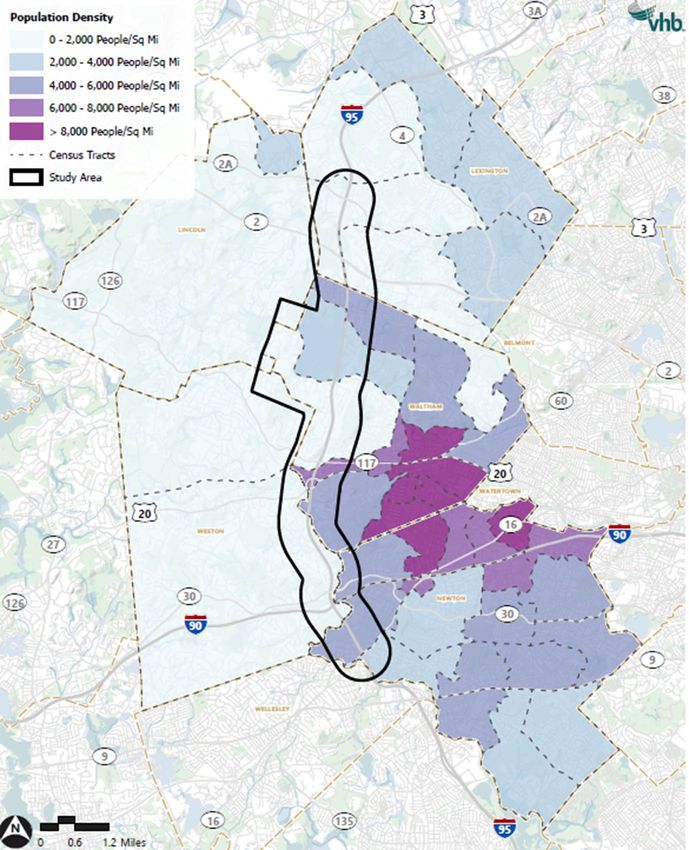
Agenda

• Project Overview
   •   Process
   •   Public Involvement
   •   Study Area

• Goals, Objectives, & Evaluation Criteria

• Existing Conditions

• Next Steps

• Public Comment
Project Team

       Economic development/   Equity/EJ, shuttles/transit   Cost estimating
          business impacts          planning, TDM            and scheduling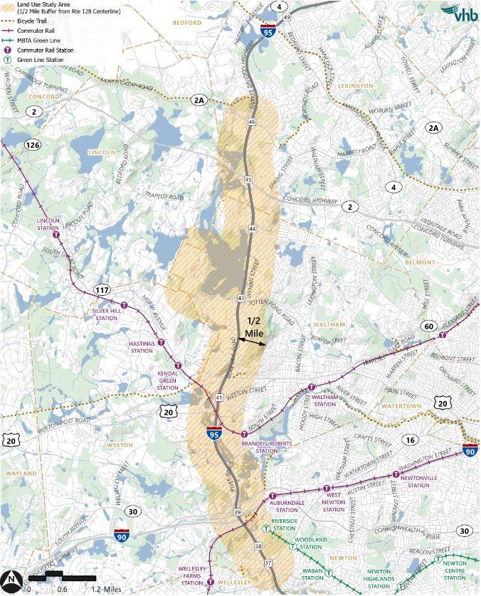
Project
Overview
Project Overview
The Route 128/I-95 Land Use and Transportation Study will
establish the future land use, housing, and economic
development assumptions.
The study area includes Route 128/I-95 between Newton and
Lexington.
The study will develop and analyze alternatives, present
recommendations and develop an implementation plan.
Study       Task 1: Study Area Goals and Objectives,
Process   Evaluation Criteria, Public Participation Plan

           Task 2 - Existing Conditions & Documenting
                          Relevant Efforts
                                                           We are here
           Task 3 - Future Year No-Build Conditions &
                       Issues Identification

               Task 4 - Alternatives Development

                  Task 5 - Alternative Analysis

          Task 6 - Recommendations & Implementation
                            Plan

                 Task 7 - Draft and Final Report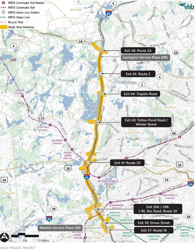
Study         Task 1: Study Area Goals and Objectives,
Process &   Evaluation Criteria, Public Participation Plan
Outreach
Phases
             Task 2 - Existing Conditions & Documenting
                            Relevant Efforts                 Reflect
             Task 3 - Future Year No-Build Conditions &
                         Issues Identification

                 Task 4 - Alternatives Development
                                                             Explore
                    Task 5 - Alternative Analysis

            Task 6 - Recommendations & Implementation
                              Plan
                                                             Confirm
                   Task 7 - Draft and Final Report
Public Involvement
•   Working Group – 6 meetings
    • The studies Working Group is comprised of elected
      officials, municipal leaders, and business community
      representatives from the five municipalities included in
      the study area: Lexington, Lincoln, Newton, Waltham,
      and Weston.
    • The Working Group will provide valuable insight to the
      needs of the region and their constituents and will help
      inform and shape the study.
•   Public Informational Meetings – 3 meetings
    • The public will be invited to learn about the progress of
      the project and provide feedback on the study analysis
      and alternatives. Three public information meetings will
      be scheduled according to major project milestones.
Online Engagement
• MassDOT Project Website
https://www.mass.gov/route-128i-95-study
• Sign up for Study updates
• General project information
• Virtual Room for online engagement
• Linked from MassDOT Project Website
• Comment form and mapping survey
• Project information, documents, and materialsStudy Area
Land Use & Environmental
Study Area
• ½ mile from Route 128/I-95 Center Line
• Captures development along Winter Street
  with primary access via Exit 43 (old Exit 27)
Transportation Study Area

• Route 128/I-95 mainline & ramps
• 42 study area intersections
• Transit – commuter rail, rapid transit,
  bus/shuttle, paratransit
• Active Transportation facilities
• Safety
Goals,
Objectives &
Evaluation
Criteria
Goals, Objectives &
Evaluation Criteria
Goals define the general intentions and purposes.
Objectives describe ways that the goals could be
accomplished.
Evaluation criteria are used to measure how well
alternatives meets the goals and objectives which
drives study recommendations
Study Goals & Objectives (1 of 2)
Improve Access, Safety, and Mobility for All                       Advance Social Equity Throughout
•   Induce a mode shift                                            •   Advance programs/policies that improve transportation choice
•   Minimize multimodal delays & improve reliability               •   Equitably distribute both benefits and burdens
•   Enhance safety                                                 •   Address lack of housing diversity, affordability, and access
•   Integrate technologies & improve customer experience           •   Maintain an open and inclusive process
•   Contribute to state of good repair                             •   Protect and preserve adjacent residential neighborhoods

Support Strategic Land Use and Economic
Vitality
•   Encourage strategies to support mobility, accessibility, and
    transportation demand management (TDM)
•   Provide connectivity & capacity to support access to jobs
•   Support local and regional plans
•   Promote placemaking
Study Goals & Objectives (2 of 2)
Contribute Environmental and Health
Benefits
• Reduce air/noise pollution, GHG emissions, & energy
consumption
• Protect the cultural and natural environment
• Promote improvements resilient to climate change impacts
• Address local environmental concerns
• Contribute to improving public health outcomes
Develop Recommendations with Lasting
Benefits
• Prioritize projects that are implementable and address needs
• Establish organizational capacity to advance
recommendations
• Leverage various funding sources to finance improvements
• Identify cost-effective solutionsInteractive Poll #1
» Which of the study goals are most important to you?
• Improve Access, Safety, and Mobility for All
• Support Strategic Land Use and Economic Vitality
• Advance Social Equity Throughout
• Contribute Environmental and Health Benefits
• Develop Recommendations with Lasting BenefitsExisting Conditions Review - Context
2021 Project Kick-off
Previous Planning Documents
                                                                                                                                                                 2021

                                                                                                                                                                          2022*
   Statewide/                                                                                                       2018-2019                                             MBTA Bus
   Regional               2011                                                                                      MassDOT Statewide                                     Network Redesign
                          MAPC Route 128                                                                            Modal Plans      2021
   Planning &             Central Corridor                                                                                            Preparing2020
                                                                                                                                                for the Future of
                                                                                                                                                                          2022*
                                                                                                                                               MBTA    Rail Vision of     Future of
   Investments            Plan                                                                                       2019             Work in the Commonwealth
                                                                                                                                                                          Telework
                          2011                                                                                       MBTA Focus40 PlanMassachusetts
                          MAPC Central                                                                               2019 and on-going
                          Massachusetts Joint                                                                        Congestion in the
                          Trail/Busway Right of                                                                      Commonwealth Report &
                          Way Study                                                                                  Follow-on Studies

                                                                                                      2017                                       2020                       2022*
                                                                            2015                      Newton Leads 2040                          Town of Weston             Bedford/Hartwell
                                                                                                      A Transportation
  Local                                                                     Town of Weston
                                                                            Housing                   Strategy for Newton
                                                                                                                                                 Community
                                                                                                                                                 Preservation Plan
                                                                                                                                                                            Complete Streets
                                                                                                                                                                            Transportation
  Planning &                                                                Production Plan            2017                                                                 Project
  Investments                                                               2015                       Town of Weston Open
                                                                                                                                 2018-2020
                                                                            South Lexington            Space and Recreation
                                                                                                       Plan                      Lexington Trends
                                                                            Transportation                                       Reports
                                                                            Study                      2017
                                                                                                       City of Waltham           2019
                                                                                                       Transportation            Riverside Vision
                                                                                                       Master Plan               Plan
* Expected completion date
Studies completed prior to 2011: 2007 Waltham Community Development Plan & 2009 Lincoln Comprehensive Plan
Route 128/I-95: What defines our baseline? • We reviewed and evaluated: • WHO makes up Study Area residents and employees? • HOW do people move around today? • WHAT are the conditions driving these decisions?
Population &
Housing
• The Route 128/I-95 corridor, in general, has a
  low residential density. Almost all residences
  are single-family detached.
• Directly along the corridor, multifamily housing
  is sparse, as is rental housing, and affordable
  housing in general. Most housing is not
  attainable to low-income buyers/renters.
• There has been little residential construction
  in the corridor over the past twenty years,
  even as the population has steadily increased
  throughout the study area.
Educational
Attainment & Income
• There is a high rate of householders with a
  Bachelor’s Degree or higher, ranging from 54%
  in Waltham, to 85% in Lexington. This is
  notably higher than the statewide rate of 44%.
• Income levels are also high. Whereas the
  median household income in Massachusetts
  was $81k in 2019, many study area tracts
  earned significantly higher.
• However, this shouldn’t mask the fact that the
  study area also contains low-income tracts,
  particularly in western Waltham, within the
  corridor.
Environmental
        Justice
        • With the exception of Weston, each of the
          municipalities have some Census Tracts that meet
          at least one environmental justice threshold
        • Consider these populations through alternatives
          analysis for fair distribution of benefits or impacts

EJ Thresholds
     1.   The annual median household income is not more than 65 percent of the statewide annual median household
          income
     2.   Minorities comprise 40 percent or more of residents
     3.   At least 25 percent of households have limited English proficiency
     4.   Minorities are 25 percent or more of the population and the annual median household income of the municipality
          is less than 150 percent of the statewide annual median household income
Land Use & Economic Conditions • The Study Area is a strong jobs center. The corridor is home to over 15 million SF of office space, with 10% growth from 2011 to 2021. • The Study Area is also home to 795k SF of retail space, with almost 30% growth from 2011 to 2021. • Industrial space is limited in the corridor (679k SF) and has decreased over the ten-year period. • During the 20-year period between 2001 and 2021, the Boston metro area increased multifamily inventory by almost 40%; in the Route 128/I-95 corridor, there was zero growth in multifamily inventory.
Employment                                                             2020 Market Profile

• There are over 39,000 employees across the
  study area tracts.
                                                                                    18%
                                                                      24%
• No single industry comprises more than 20% of
  the total employees. The highest share of
                                                                 5%                          17%
  workers are in the Professional, Scientific and                 6%
  Management, and Tech Services industry, with                        7%
                                                                                   15%
                                                                            8%
  over 7,000 employees.
• This number grew by over 14% between 2011
  and 2021, signaling strong continued growth in
                                                    Professional, Scientific, and Management, and Tech Services
  this job base.                                    Educational Services
                                                    Health Care and Social Assistance
• These are typically high-paying jobs, so this     Manufacturing
  growth contributes directly to inflation in the   Finance and Insurance
                                                    Retail Trade
  local economy and housing market.                 Accommodation and Food Services
                                                    Other (Industries with less than 5% of total employment)
Mode Share & Vehicle Ownership • Mode shares differ significantly between municipalities - related to development density and availability of transit and active transportation facilities • Less than 2% of households do not own a vehicle
Existing Travel Patterns
• Many trips among study area municipalities (45%)
    • Shorter trips that conducive to walking or biking
• Majority of worker trips (65%) outside the study area
    • Regional study area workforce driven by a lack of
      local housing options
• Over 50% of resident trips among study area
  municipalities
    • Connection of high-income earners working/living
      within the study area
• Between 8-10% of trips from/to Boston
    • Significant O-D pair served by limited transit
      options
Public Health • Study area has a similar average risk for chronic diseases to the surrounding study area municipalities and Boston Metro Area • Commuting time and commute mode were found to have a strong correlation with all of the chronic diseases except for asthma • Asthma prevalence is greater than it is nationally focus improved walkability and decreased vehicle miles travelled/emissions.
Environmental Conditions
• An inventory of study area environmental
  conditions was conducted to set the stage for
  Alternatives Development/Analysis:
   • Natural Resources
   • Historic and Archaeological Resources
   • Oil and Hazardous Materials
• The study area contains a variety of
  environmental resources that are important to
  the health and quality of life of the intersecting
  municipalities and the region more broadly
Existing
Conditions
Review -
Transportation
How does the context relate to
transportation conditions?
• We reviewed and evaluated existing
transportation conditions:
• Roadways & Intersections: Route 128/I-95
and study area intersections
• Transit – commuter rail, rapid transit,
bus/shuttle, paratransit
• Active Transportation
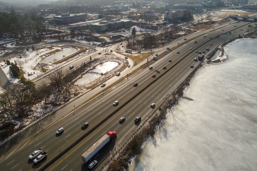
• SafetyRoute 128/I-95
Northbound 3 PM:
20 min on average, can vary
• Route 128/I-95 Traffic Patterns up to 35 min
• 184,000 daily vehicles
• Extended “rush hour” periods
• 2% average growth per year
• During the pandemic, daily volumes
dropped 29%
• Completed HCS analysis of average Southbound
annual condition and reviewed Inrix
data to understand reliability
• Level of Service (LOS) E/F
conditions on several mainline
segments, ramps and weave areas
during both peak hours
• Travel times vary widely and in Source: INRIX. Jan-Dec 2019 Tues-Thurs average.
5 PM:
some hours of the day nearly double 20-25 min on average, can
– resulting in unreliability for vary up to 40 min
travelersStudy Area Intersections (North)
• Intersection operations are tied closely with AM LOS
PM LOS
mainline operations – in some cases, queues = LOS A/B
= LOS C/D
spillback to adjacent intersections = LOS E/F
• Several intersections with operational
deficiencies
• Route 2A/Mass Ave
• Route 2A/128 NB ramps
• Trapelo Road/Data Drive/128 SB on-rampStudy Area Intersections (Center)
• Intersection operations are tied closely with AM LOS
PM LOS
mainline operations – in some cases, queues = LOS A/B
= LOS C/D
spillback to adjacent intersections = LOS E/F
• Several intersections with operational
deficiencies
• Route 117/Jones Road
• Route 117/Green Street
• Route 117/Bear Hill Road
• Route 117/Stow Street
• Route 20/Summer StreetStudy Area Intersections (South)
• Intersection operations are tied closely with AM LOS
PM LOS
mainline operations – in some cases, queues = LOS A/B
= LOS C/D
spillback to adjacent intersections = LOS E/F
• Several intersections with operational
deficiencies
• Route 30/Newton Street
• Route 30/Park Road
• Route 30/128 SB ramps
• Park Road/90 EB ramp
• Grove Street/Asheville Road/Quinobequin Road
• Grove Street/MBTA driveway
• Route 16/ Quinobequin Road
• Route 16/128 NB rampsTransit - Rail
• MBTA Commuter Rail – 2 lines, 6 stations
in/near the study area
• 60 min headways
• Approximately 1,800 daily boardings
• Nearly 600 parking spaces
• MBTA Rapid Transit – Green Line D Branch, 2
stations in/near the study area
• 7 min headways
• Approximately 650 daily boardings
• Riverside has the highest number of boardings of
D Branch surface stations
• Nearly 1,500 parking spacesTransit - Bus
• MBTA Bus – 5 routes in/near the study area
• Headways range 10-90 min
• Approximately 10,300 daily boardings on routes serving
the study area
• Route 70 is a high-ridership route
• Route 558 is the only MBTA bus route to travel on Route
128/I-95 in the study area
• 128 Business Council - 6 routes stop within the study
area
• 30-60 min headways
• Approximately 500 daily boardings
• Routes stopping in the study area carry approximately
70% of 128 Business Council ridership
• RTAs, Lexpress, MIT Shuttle – 5 routes in/near the
study area
• Headways every 60 minutes or less
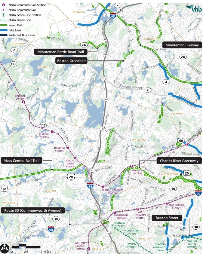
• The RIDE – MBTA paratransit serviceActive Transportation • 5 trails/paths in close proximity to the study area • Intermittent sidewalks and on-street bike accommodations • Limited north-south connections
Safety
• Hot spots at interchanges correlates to
congestion and influenced by entering and
exiting traffic maneuvers
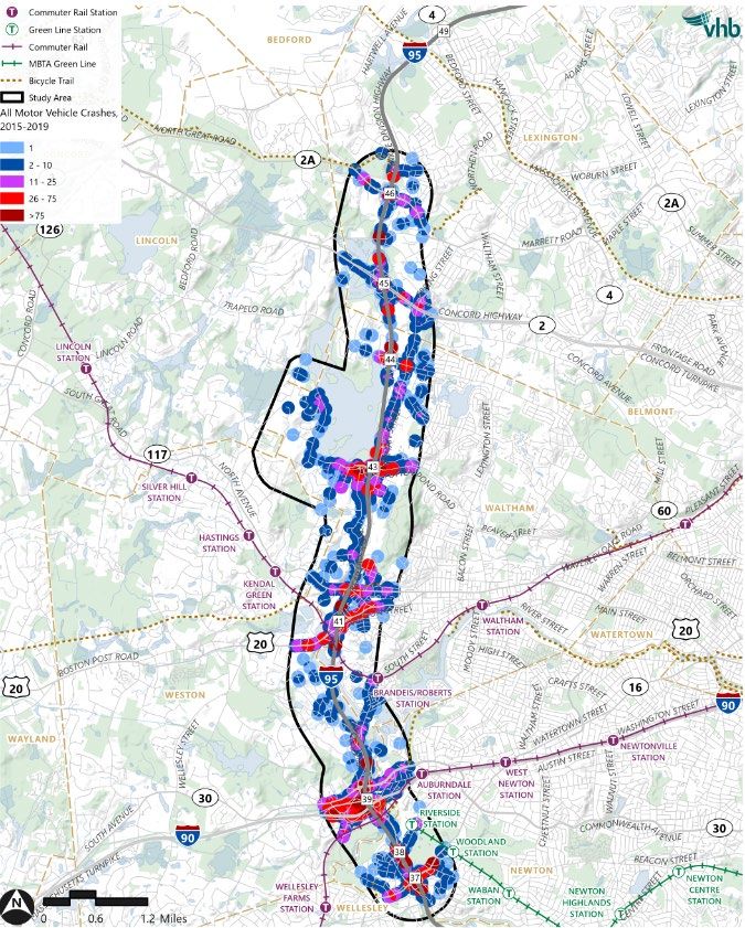
• Crash trends (2015-2019)
• Fatalities = 3 occurred along Route 128/I-95
• Ped/Bike = 60 within study area
• Risk sites identified by MassDOT as
locations that can be improved to help
reduce fatal/injury crashes
• Ped/bike – segments of Totten Pond Road,
Route 117, Route 20
• Large Vehicle – along Route 128/I-95 and I-90Interactive Poll #2
» What is the biggest challenge to traveling in this area?
• Limited transit options
• Lack of pedestrian/bicycle facilities
• Traffic congestion on the highway
• Traffic congestion on the local roads/ramps to the highway
• Unreliable travel times
• Safety concerns
• OtherLook Ahead
Our next steps

     1                         2                     3                       4

Incorporate stakeholder   Advance Future        Working Group           Refine issues,
input                     Conditions analysis   Meeting #3:             opportunities, &
                          Summarize issues,     Future Conditions       constraints
                          opportunities, &      Review & Alternatives
                          constraints           Development
                                                (Spring 2022)
2040 Future Conditions Under development based on: • Statewide Travel Demand Model employment & population projections • Known developments in the pipeline • Planned infrastructure improvements
Schedule

                     WG 1                           WG 2       Public    WG 3         Public               WG 4

Project                     Existing                       Future               Alternatives            Alternatives
Framework                   Conditions                     Conditions           Development             Analysis
Summer/Fall 2021            Fall/Winter 2021/2022          Winter 2022          Spring 2022             Summer/Fall 2022

    WG 5    Public   WG 6

Recommendations Draft & Final Report
Fall 2022                   Winter/Spring 2023
                                                                                                         Working Group Meeting
                                                                                                WG

                                                                                                         Public Meeting
                                                                                               Public
Public Comment
Share Your Questions and Comments

          • “Raise your hand” to be unmuted for verbal questions

          • Submit your questions and comments using the Q&A button

          • Please state your name before your question

          • Please share only 1 question or comment at a time, limited to 2 minutes, to
   1        allow others to participate.

          • To ask a question via phone, dial *9 and the moderator will call out the last 4-
   *9       digits of your phone number and unmute your audio when it is your turn.

          • You will receive a survey after the meeting. Please take a few minutes to let
            us know how we did and can improve.

   Please be advised that all Q&A and chats are subject to disclosure for public records,
              therefore use these functions for project related business only
Thank You Project Website https://www.mass.gov/route-128i-95-study Liz Williams – Project Manager liz.williams@state.ma.us
You can also read