Rajgad GPB: A megaporphyritic Cow Beld, Western Deccan Volcanic Province, India
←
→
Page content transcription
If your browser does not render page correctly, please read the page content below
J. Earth Syst. Sci. (2020)129:113                                                                                  Ó Indian Academy of Sciences
https://doi.org/10.1007/s12040-020-1375-3      (0123456789().,-volV)(0123456789(
                                                                             ).,-volV)

Rajgad GPB: A megaporphyritic Cow Beld, Western
Deccan Volcanic Province, India

PRIYANKA SHANDILYA1, POUSHALI CHATTERJEE2, KONDEPUDI PATTABHIRAM1,
MAKARAND BODAS2, KANCHAN PANDE1 and VIVEK S KALE3,*
1
  Department of Earth Sciences, Indian Institute of Technology Bombay,
                                                                 Powai, Mumbai 400 076, India.
2
  Geological Survey of India (CR), SU: Maharashtra, Alandi Road, Pune
                                                                 411 006, India.
3
 Advanced Center for Water Resources Development and Management (ACWADAM), Kshipra Society,
Pune 411 058, India.
*Corresponding author. e-mail: dr.vivekale@gmail.com

MS received 2 November 2019; revised 1 February 2020; accepted 7 February 2020

We describe the distribution and characters of a megaporphyritic basalt Cow Beld that was arguably the
earliest described ‘giant phenocryst basalt’ (GPB) from the Deccan Volcanic Province (DVP). It is a
marker horizon exposed in a[30,000 km2 area below the Mahabaleshwar Formation in the western DVP.
Its presence, distribution and stratigraphic importance as a regional marker horizon are enumerated.
Available geochronological and paleomagnetic data suggest that the stratigraphic position of the Rajgad
GPB coincides with polarity reversal in Chron 29 recorded from the basaltic lava sequence of the Western
DVP.
Keywords. GPB; Basalt lava Cow Beld; Deccan Volcanic Province; Chron 29.

1. Introduction                                                                          occurring at multiple levels in the vertical sequence
                                                                                         of the Deccan volcanics for marking stratigraphic
The earliest description of a megaporphyritic                                            boundaries in the western DVP was recorded by
basalt Cow from the Deccan Volcanic Province                                             Beane et al. (1986), Bodas et al. (1988), Khadri
(DVP) India may be attributed to Sowani and                                              et al. (1988, 1999), Godbole et al. (1996) and
Peshwa (1964) who described its exposure in the                                          Hooper et al. (1988). Similar GPBs have been
Purandar hills (about 30 km southeast of Pune).                                          subsequently described from different parts of the
They coined the term ‘giant phenocryst basalt’                                           DVP in the maps of the Geological Survey of India
(=GPB) to describe this basaltic Cow in which the                                        (GSI 1994, 2001) and other authors (e.g., Ghosh
plagioclase phenocrysts were *100 times larger                                           2011; Talusani 2012; Alexander and Purohit 2019).
than the groundmass grain size. It was pointed out                                       Their petrogenetic significance was discussed by
that such giant phenocrysts are present only in                                          Sen (2001, 2002), Higgins and Chandrasekharam
parts of the GPB, while other parts display large                                        (2007), Sheth (2016) and Krishnamurthy (2019).
phenocrysts visible to the naked eye in exposures                                          The GPB from Purandar fort-hill was named as
(Karmarkar et al. 1971). The utility of GPBs                                             ‘M4’ in the lithostratigraphy of the Western DVP

Supplementary materials pertaining to this article are available on the Journal of Earth Science Website (http://www.ias.ac.in/
Journals/Journal˙of˙Earth˙System˙Science).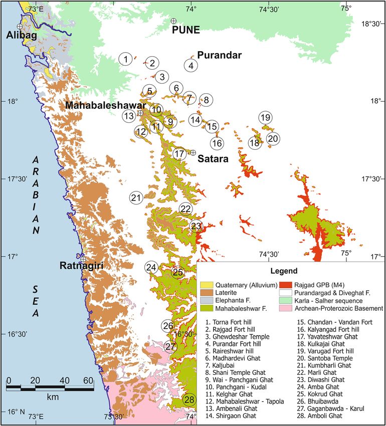
113       Page 2 of 11                                              J. Earth Syst. Sci. (2020)129:113

(Godbole et al. 1996; Kale et al. 2019). This hori-           have named it as the Rajgad Giant Porphyritic
zon, however, Bnds no mention in the literature of            Basalt (Rajgad GPB – for short). Its petrogenesis
chemical stratigraphy (Cox and Hawkesworth                    and related implications are beyond the purview of
1985; Beane et al. 1986; Subbarao and Hooper                  this contribution, which focuses on its wide-spread
1988), barring a passing reference many years later           distribution, volcanological description and rele-
to the occurrence of megaporphyritic basalt within            vance in the stratigraphy of the western DVP.
the (chemical) Mahabaleshwar Formation (Jay
2005). We describe the occurrence, distribution,              2. Rajgad GPB
general volcanological and petrological characters
of this megaporphyritic horizon across an area of             2.1 Distribution and Beld relations
*150 km 9 *250 km, south and southwest of
Pune city (Bgure 1). It is constituted of more than           This horizon from the western DVP was Brst
one lava Cow and hence is recognised as a Cow-                described from exposures in the hill-fort of Puran-
Beld. To avoid nomenclatural confusion with the               dar south of Pune city (Sowani and Peshwa 1964;
(lithostratigraphic) Purandargarh Formation, we               Karmarkar et al. 1971) and then traced south and

Figure 1. Geological map of the western DVP south of Pune depicting the occurrence of Rajgad GPB. The basemap was
compiled using the data from GSI (1994, 2001). The lithostratigraphic classiBcation of the DVP (Kale et al. 2019) has been
followed. The locations of the measured vertical sections of the Rajgad GPB (see table 1) are marked by numbers 1–28.
J. Earth Syst. Sci. (2020)129:113                                                                      Page 3 of 11 113
Table 1. Locations, elevations and thicknesses of the exposures of the Rajgad GPB (M4) measured in different sections of
Western DVP. NA indicates that this horizon is at the top of the hill; and consequently the thickness is incomplete (indicated by a
+ sign). The base of the Amboli Ghat (#28) section is tentative, since intense weathering has masked the exposures. The Kulkajai
Ghat (#18) section has two megaporphyritic Cows, with an intervening non-megaporphyritic Cow.

                                                                               Exposure elevation
                                                             Position          in meters above msl
                    Section measured                                                                      Exposed thickness
No.            (refer Bgure 1 for location)            Latitude Longitude        Base        Top             in meters
1     Torna Fort hill                                  18.28°N     73.62°E       1220       1354                  134
2     Rajgad Fort hill                                 18.25°N     73.68°E       1212        NA                  +93
3     Ghewdeshwar Temple                               18.15°N     73.73°E       1214        NA                  +21
4     Purandar Fort hill                               18.28°N     73.98°E       1197       1228                   31
5     Raireshwar                                       18.02°N     73.74°E       1090       1150                   60
6     Madhardevi Ghat                                  18.04°N     73.87°E       1085       1142                   57
7     Kaljubai                                         17.98°N     73.95°E       1059       1105                   46
8     Shani Temple Ghat                                17.99°N     74.02°E       1064        NA                  +48
9     Wai–Panchagani Ghat                              17.93°N     73.84°E       1022       1065                   43
10    Panchgani–Kudal                                  17.92°N     73.79°E       1020       1072                   52
11    Kelghar Ghat                                     17.89°N     73.73°E       1014       1090                   76
12    Mahabaleshwar–Tapola                             17.87°N     73.68°E       1115       1145                   30
13    Ambenali Ghat                                    17.92°N     73.63°E       1065       1076                   11
14    Shirgaon Ghat                                    17.88°N     74.05°E        995       1105                  110
15    Chandan–Vandan Fort                              17.83°N     74.06°E        936        996                   60
16    Kalyangad Fort hill                              17.78°N     74.13°E        942        992                   50
17    Yavateshwar Ghat                                 17.69°N     73.86°E        911       1027                  116
18    Kulkajai Ghat                                    17.79°N     74.38°E        956       1047                   91
19    Varugad Fort hill                                17.85°N     74.44°E        925        937                   12
20    Santoba Temple                                   17.82°N     74.49°E        945        970                   25
21    Kumbharli Ghat                                   17.39°N     73.67°E        672        726                   54
22    Marli Ghat                                       17.29°N     73.95°E        776        830                   54
23    Diwashi Ghat                                     17.27°N     73.98°E        763        864                  101
24    Amba Ghat                                        16.98°N     73.78°E        520        603                   83
25    Kokrud Ghat                                      16.96°N     73.96°E        746        763                   17
26    Bhuibawada                                       16.55°N     73.83°E        461        528                   67
27    Gaganbawada–Karul                                16.53°N     73.83°E        506        531                   25
28    Amboli Ghat                                      15.95°N     73.99°E      *615         632                 *15

east-wards across large distances during the map-                 Rajgad and Purandar hill-forts and their sur-
ping by the Geological Survey of India as ‘M4’ (GSI               roundings), it occurs at elevations of 1200 m
1994, 2001; Chatterjee and Dash 2017). Figure 1 is                above msl. About 20 km southwards, it occurs at
a compiled map from these inputs, based on its                    elevations of 1100 ± 20 m in the Mandhardevi
lateral continuity established during this study.                 hills. In the Wai–Panchgani–Mahabaleshwar
During the traverses, the elevations of various                   plateau, the elevations of the base of the Rajgad
contacts were recorded using GPS measurements                     GPB are *1000 m above msl, and progressively
and tallied with the Survey of India topographic                  reduce further in the Kolhapur and Sangli dis-
data. Table 1 is a compilation of the altitudes and               tricts to around 700 m above msl. It appears to
thicknesses of this horizon in the sections studied               die-out south-eastwards beyond Jat (Jath) and is
by us. Its volcanological characters and interrela-               not encountered in the eastern side of the Sola-
tions with the overlying and underlying lava Cows                 pur district beyond the present course of the
were recorded in these sections.                                  River Krishna. This shows that there is a regio-
   The district-wise composite stratigraphic logs                 nal dip of the order of 18–38 towards south to
(Bgure 2) are compiled to represent the difference                south-east for the base of this horizon on the
in altitudes of the exposures of the Rajgad GPB.                  Deccan Plateau, with local undulations having
In the northern hill ranges (hosting the Torna,                   amplitudes of a few 10s of metres (table 1).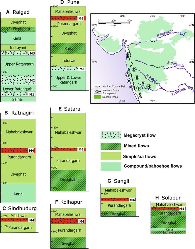
113        Page 4 of 11                                                  J. Earth Syst. Sci. (2020)129:113

Figure 2. Composite district-wise logs of the lithostratigraphic sequence of lava Cows exposed in the districts south and west of
Pune. The locations of the logs are given in the inset map that depicts the outline of the DVP. The lithostratigraphic formation
boundaries are plotted at average altitudes within that district, based on an overlay analysis of the DRM sheets (GSI 2001) on
Google Earth DEM data (Kale et al. 2019), and validated by GPS measurements during Beld studies. The elevations of the
occurrence of M4 may vary by ±20 m from its plotted position in different sections within the district. Note that the logs A–C are
in the Konkan Coastal Belt, separated from the other logs by the Western Ghats Escarpment. There is no exposure of M4 in the
Raigad District, which is given to depict the relation of the Rajgad GPB (M4) with the other stratigraphically significant
megaporphyritic horizons in the lower sequences of basaltic Cows.

   GSI (2001) recorded the occurrence of this                     Escarpment) are deeply weathered and often cap-
horizon (M4) at variable elevations between *520                  ped by a lateritic cover, making it difBcult to
and *150 m above msl in the Ratnagiri and                         examine them. Whether this elevation difference of
Sindhudurg districts, respectively (Bgure 2). These               more than 300 m across the Western Ghats
exposures in the Konkan Coastal Belt (separated                   Escarpment is a result of the westward tilting of
from the Deccan Plateau by the Western Ghats                      the stack of Deccan Trap lavas, or simply a steeper
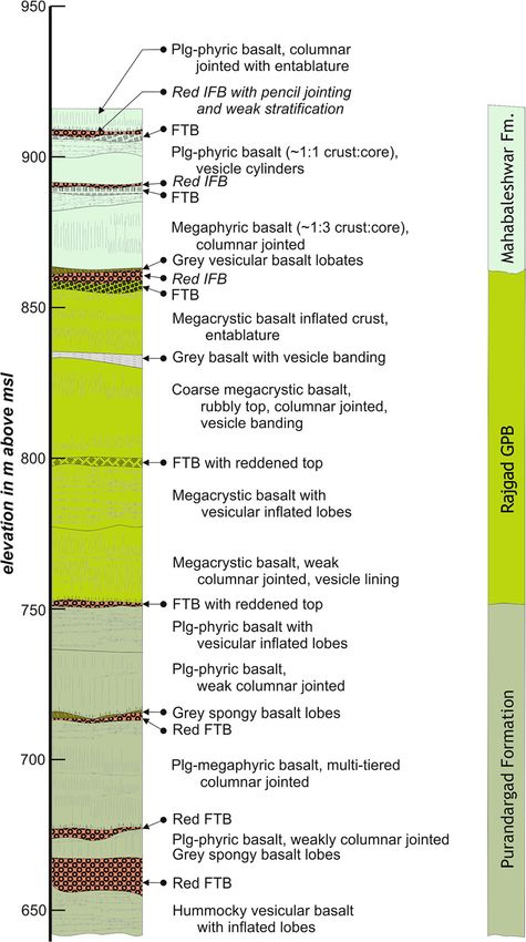
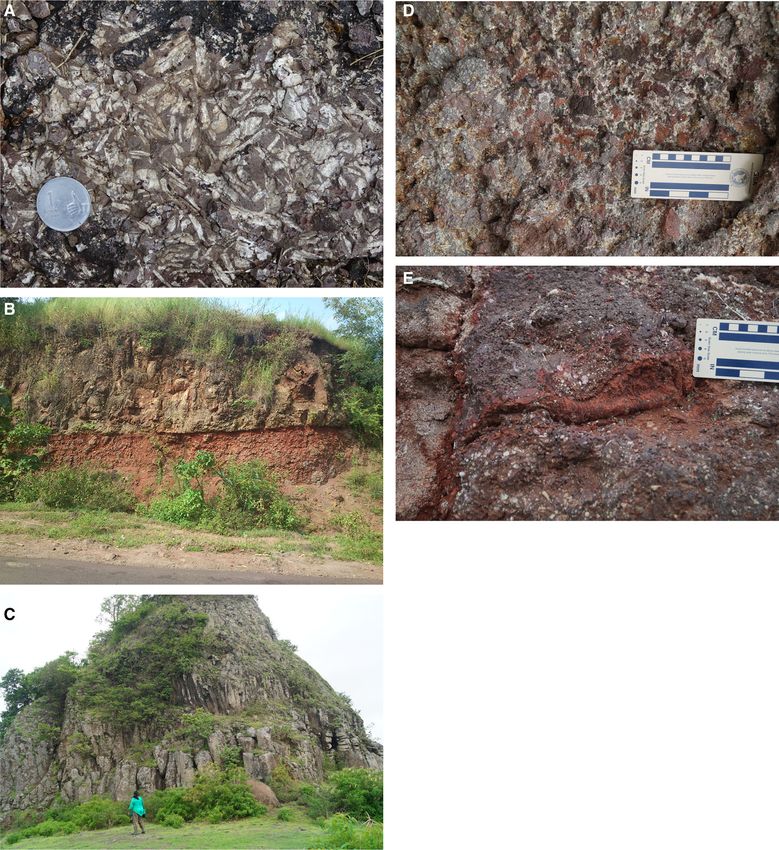
J. Earth Syst. Sci. (2020)129:113                                                                    Page 5 of 11 113

Figure 3. (A) GPB exposed in the Rajgad fort hill. Note the presence of vesicles occurring as small open cavities. (B) Sharp,
gently undulating contact between (i) the megaporphyritic Cow and (ii) the underlying red powdery tuAaceous interCow horizon
resting with a gradational contact on the Cow-top breccia of the underlying Cow in the Diwashi Ghat section. (C) Multi-tiered
columnar jointing in the core portion of a megaporphyritic Cow exposed at Kalyangad. Note the difference in the diameters of the
columns in different layers. (D) Flow-top breccia containing fragments of glassy material as well as vesicular megaporphyritic
basalt exposed in Kalyangad section. (E) Ropy striations encountered at the chilled glassy margin of a lobe and the subvertical
red tachylitic squeeze-up on the left within the Cow-top breccia of the megaporphyritic Cow exposed at Kalyangad.

regional dip of the stratum contours; or a result of             section (#2 in table 1 and Bgure 1) is an incom-
intervening concealed blind faults (with western                 plete one. Based on the quality of exposures
downthrow) is open to conjecture at this stage.                  (Bgure 3A) and ease of sampling, we therefore
  The thickness of this horizon is variable, with the            propose the formal name of ‘Rajgad GPB’ for this
maximum thickness in the Torna fort hill followed                horizon (see: Supplementary data #1) that is
by the Yavateshwar Ghat section. However, since                  continuously traceable across a very large area as a
the horizon does not have a capping Cow in the                   marker horizon. It’s commonly recorded thick-
Rajgad fort hill, the measured thickness in that                 ness ranges between 50 and 60 m, but displays a
113        Page 6 of 11                                              J. Earth Syst. Sci. (2020)129:113

                                                                2.2 Volcanological characters

                                                                The exposures of the Rajgad GPB are charac-
                                                                terised by large plagioclase phenocrysts that
                                                                are visible in weathered and fresh surfaces to the
                                                                naked eye (see Bgures 3A and Supplementary
                                                                Bgures S1–S5). We have used established parame-
                                                                ters such as presence of interCow horizons (often
                                                                referred to as interCow red-boles), Cow-top breccias
                                                                and reddened chilled glassy crusts to demarcate the
                                                                boundaries between individual Cows and lobes.
                                                                Most of the lava Cows in these sequences (including
                                                                the megaporphyritic basalts) were classiBed as
                                                                ‘simple’ Cows (sensu Deshmukh 1988). They dis-
                                                                play a tripartite internal layering constituted of the
                                                                lower vesicular zone (LVZ), compact core and
                                                                upper crust (Keszthelyi et al. 1999). The LVZ is
                                                                usually\10% of the thickness of the Cow, while the
                                                                ‘crust:core’ thickness ratio is normally in the range
                                                                of 1:1.5 to 1:2. Morphologically, these Cows display
                                                                characters of slabby or rubbly pahoehoe Cows
                                                                (Duraiswami et al. 2014) and may be classiBed as
                                                                ‘sheet lava Cows’ (Kale et al. 2019; Kale 2020).
                                                                   The lower vesicular zone (LVZ) rests on the
                                                                underlying Cow or interCow horizon with a sharp
                                                                contact (Bgure 3B). The LVZ often contains pipe
                                                                vesicles and cavities of variable sizes (Supplemen-
                                                                tary Bgure S6). In some exposures, the high vesic-
                                                                ularity of LVZ gives it a spongy appearance.
                                                                Sometimes, small bun-shaped toes (Supplementary
                                                                Bgure S7) or lobes with chilled glassy rinds (up to
                                                                50 cm thick and a few metres wide) are encoun-
                                                                tered at the base of the LVZ. Squeeze-down,
Figure 4. Composite log of the Diwashi Ghat section
(17°160 5200 N, 73°580 0300 E) depicting the exposures of the
                                                                squeeze-up, axial clefts and ropy striations on the
horizon marked as M4 in the GSI DRM sheets. The Rajgad          chilled contacts of such subordinate lobes are seen
GPB comprises of three lava Cows in this section. The           at places in the different exposures.
elevations of contact vary by ±7 m in different parts of this      The compact core of these Cows is significantly
hill-range as a result of undulating contacts and pinching of
                                                                depleted in vesicles as compared to crust or the
some of the Cows.
                                                                LVZ. The core displays columnar joints (often
                                                                multi-tiered: Bgure 3C) horizontal vesicle bands
pinch-and-swell geometry across its exposures.                  (Supplementary Bgure S8) and vesicle cylinders.
The thicker exposures (exceeding 80 m) do not                   Entablatures are occasionally seen. This is gener-
appear to following any speciBc geographic                      ally the thickest part in the Cow, occupying more
distribution.                                                   than half its thickness. The upper vesicular crust in
   Significantly, this horizon does not necessarily             these Cows is commonly disrupted into a Cow top
rest on the same lava Cow from the underlying                   breccia (FTB) which contains unsorted, angular to
Purandargad Formation (Chatterjee and Dash                      semi-rounded clasts of vesicular basalt embedded
2017). This indicates that the lavas that had been              in a ferruginous tuAaceous Bne-grained matrix
erupted prior to the Rajgad GPB may have had                    (Bgure 3D). Presence of glassy and tuAaceous veins
relatively limited lateral extent as compared to it,            and small toes entrapped into the vesicular crust
and that they occasionally pinched out. The GPB                 (Bgure 3E) suggests that some components of this
Cow Beld overstepped several such underlying                    material remained viscously mobile during the last
Cows.                                                           phases of its cooling and consolidation. When not
J. Earth Syst. Sci. (2020)129:113
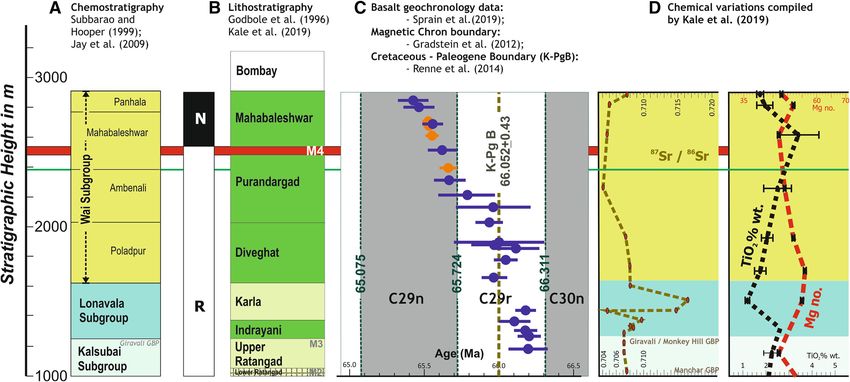
Figure 5. Compilation of the (A) chemostratigraphic column, (B) lithostratigraphic column, (C) geochronology, and (D) chemical variations in the sequence of the basaltic
Cows occurring in the Western DVP based on various sources. The position of the Rajgad GPB (M4) in this is marked by the red band, while the boundary between the chemical
Mahabaleshwar and Ambenali formations is marked by a thin green band. Note that the paleomagnetic change in polarity recorded within the Mahabaleshwar Formation
(chemical) by Jay et al. (2009) corresponds exactly with the stratigraphic position of the Rajgad GPB. The precision age of the C29n–C29r boundary has been recomputed at
65.724 ± 0.013 Ma by Sprain et al. (2018).
Page 7 of 11 113113 Page 8 of 11 J. Earth Syst. Sci. (2020)129:113
fragmented completely, such vesicular crusts dis- places. The distribution of phenocryst concentra-
play a slabby appearance. Locally, domed up crust tions within the lava Cow does not follow any sys-
(akin to large tumuli) may be observed yielding a tematic pattern, although larger phenocrysts
hummocky appearance to the lava Cow. appear to be more common in the upper parts of
A noteworthy aspect that our studies show is the core or in the crust than in the lower parts of
that the Rajgad GPB is not a single lava Cow. the Cows. Phenocryst concentrations and sizes also
Some sections display presence of a single lava Cow, display variations laterally along the length of the
but most have more than one. It is a Cow-Beld same lava Cow in this horizon.
constituted of up to three individual megapor- It is relevant to note that samples collected from
phyritic lava Cows stacked one above the other and the different exposures conBrm the chemical con-
separated by an interCow horizon or by a chilled sistency of the composition of this horizon across
tachylitic rim. The Kulkajai section is unique in its length and width. Whether it occurs as a single
that it displays an intervening non-megapor- lava Cow unit or as a series of 2–3 lava Cows sep-
phyritic lava Cow interlayered between megapor- arated by interCow horizons, this petrological
phyritic Cows. The Diwashi Ghat section south of consistency of the Rajgad GPB Cow-Beld is unde-
the Koyna River valley (Bgure 4) is a perfect niable. The presence of such uniformity in petro-
example of the multiple megaporphyritic Cows. logical character across such a wide area, barring
Similar constitution of multiple Cows comprising the variations in the concentrations and sizes of the
this horizon can also be studied in the Rajgad, plagioclase phenocrysts is remarkable. The anor-
Torna and Kalyangad sections (Bgure 1). The thite contents of the labradoritic plagioclase in the
Rajgad GPB horizon is therefore recognised as a phenocryst phase (see Supplementary data) vary
‘Cow-Beld’ rather than single lava Cow. between 66.2% and 57.9%; while in the groundmass
the An-contents of plagioclase are slightly lower
(57.2%–50.5%). The marginally higher Ca contents
2.3 Petrological characters in the phenocrysts than the groundmass is an
indication of a slightly more evolved composition of
The Rajgad GPB lava Cows are constituted of typical the latter than the former, but does not provide a
megaporphyritic basaltic Cows. The (labradorite) significant differentiation between them.
plagioclase phenocrysts are visible to the naked eye However, as mentioned earlier, the detailed
occurring as glomeroporphyritic aggregates as well as petrogenesis is outside the purview of this manu-
single large phenocrysts. The groundmass is usually script pending additional data. The lack of mean-
Bne grained, although at some places, medium ingful compositional differences (other than normal
grained groundmass is also observed. The subophitic zoning in the plagioclase) between the phenocryst
groundmass is made up of subequal parts of plagio- and groundmass phase needs to be explained while
clase and pyroxenes (Fe-pigeonite and augite) with doing so, since it appears to contradict the sug-
minor amounts of ilmenite, titano-magnetite and gestion that the phenocryst phase evolved prior to
occasional vesicular cavities lined with glassy mate- the emplacement of the lava on the surface (e.g.,
rial. Representative chemical analyses of samples of Higgins and Chandrasekharam 2007; Sheth 2016).
the GPB and plagioclase (both phenocryst and Large phenocrysts in partially molten lava have
groundmass phase) compositions based on EPMA been demonstrated to aAect its rheology and vis-
analyses are given in the Supplementary data. In cosity (Costa et al. 2009; Del Gaudio et al. 2013).
addition, binary plots of the composition of these The morphological characters in different sections
GPB samples with that of published compositions of do not appear to adhere to any speciBc pattern,
other GPB horizons from the western DVP are thereby adding to the question of whether the
included in the Supplementary data #3. phenocryst phase was indeed crystallised prior to
Laths up to 5 cm long have been recorded from the emplacement of the lava on the surface.
most of the exposures of this horizon. However, it is
also noted that such giant phenocrysts are not
evenly present across the entire Cow, but tend to 3. Discussion
cluster in patches or layers. The other parts display
a megaporphyritic character consistently. Cross- Although Brst recorded more than 50 years ago, the
twins (see Supplementary Bgures S2, S5) and par- Rajgad GPB Cow-Beld has been curiously missed in
allel-oriented laths have been recorded at different most subsequent studies in the Western DVPJ. Earth Syst. Sci. (2020)129:113 Page 9 of 11 113
except in the work of the Geological Survey of recognised as the local exposure of the Rajgad
India. This is a persistent and widespread Cow-Beld GPB.
that serves as a notable marker horizon in the Godbole et al. (1996) and GSI (2001) place M4
exposures across the entire southern part of the (= the Rajgad GPB) at the base of the Maha-
western DVP (Bgure 1). We focus here only on its baleshwar Formation. We endorse that the Rajgad
stratigraphic importance and note that its petro- GPB provides a physical marker enabling the
genetic implications and implications on the vis- unambiguous separation between the lithostrati-
cosity of the lava and its capacity to spread across graphic Mahabaleshwar and Purandargad Forma-
large areas are subjects of work-in-progress. We re- tions; but refrain from clubbing it with either of the
emphasised that this megaporphyritic horizon is a two. This also emphasises the robust nature of the
Cow-Beld comprising of more than one sheet lava lithostratigraphic classiBcation using physical vol-
Cows that display a remarkable compositional canological characters and Cow-by-Cow mapping
consistency across the large area of its exposures. (see: GSI 2001; Kale et al. 2019) and its advantage
over the prevailing chemical stratigraphy of the
sequence of Deccan Trap lavas in the western
3.1 Stratigraphic
DVP.
The prevailing chemical stratigraphy of this part of Figure 5 provides a snapshot of the stratigraphic
the DVP comprises of the Wai Subgroup, divided position of the Rajgad GPB Cow-Beld on the
into the Poladpur, Ambenali and Mahabaleshwar backdrop of the comparison between chemical and
formations (Cox and Hawkesworth 1985; Subbarao lithological classiBcations and allied data on this
and Hooper 1988; Jay and Widdowso 2007). sector of the DVP. It is concluded that the earlier
Absence of a GPB Cow separating these formations base of the (chemically deBned) Mahabaleshwar
(Sheth 2016: p. 721) was marked as being a char- Formation needs to be reassigned to the upper
acter of the Wai Supgroup differentiating it from boundary of the Rajgad GPB horizon (Bgure 4).
the older Kalsubai Subgroup constituted of for- This raises the elevations of the base of the
mations with picritic lavas at the base and GPB Mahabaleshwar Formation by not less than 100 m
lavas on their top (Hooper et al. 1988). The Wai in the sections south and southwest of Pune than
Subgroup (hosting the Cretaceous–Palaeogene those mapped by earlier workers.
(K–Pg) boundary) has been inferred to represent a
phase of volumetrically larger and swifter volcanic 3.2 Paleomagnetic
eruptions in the DVP, dramatically different from
the earlier eruptive rates (Richards et al. 2015; The position of this horizon in the Wai–Panchgani
Renne et al. 2015). The magnetic polarity change section matches exactly with the location of the
(from reverse to normal) occurs within the Maha- change in paleomagnetic polarity recorded in the
baleshwar Formation according to this stratigra- basaltic lavas from the western DVP (Jay et al.
phy and model (Jay et al. 2009). 2009). It is therefore likely that the Rajgad GPB
The chemical boundary between the Ambenali Cow Beld marks the transition between magnetic
and Mahabaleshwar formations deBned by Cox and chrons 29r and 29n. The Mahabaleshwar Forma-
Hawkesworth (1985: p. 363) is based on a change in tion resting above the Rajgad GPB is a normal
the Sr87/Sr86 ratio ‘from 0.704 to 0.705’ and a polarised sequence.
change in Ni and Ba contents. They marked this The exercise of weighted mean recalibrated ages
boundary at 900 m above msl in the Mahabalesh- from the western DVP (Kale et al. 2019) indicated
war plateau, Kelghar and Wai–Panchgani sections that the entire sequence from (chemical) Jawahar
(Bgure 5); as reafBrmed by other workers (NajaB to Ambenali Formations have mutually indistin-
et al. 1981; Subbarao and Hooper 1988; Mitchell guishable ages that plot within the paleomagnetic
and Widdowson 1991; Jay et al. 2009; Sheth 2016). chron 29r and straddle the Cretaceous–Paleogene
The boundaries between the formations of the Wai boundary. The recent precision dating of the
Subgroup based on chemical parameters are over- sequence in the western Deccan (Renne et al. 2015;
lapping and non-diagnostic (Kale et al. 2019). The Sprain et al. 2019; Schoene et al. 2019) are consis-
passing mention of the megaporphyritic basalt at tent with this conclusion. We therefore conclude
an elevation of around 1000 m within (chemical) that the Rajgad GPB marks the transition between
Mahabaleshwar Formation by Jay (2005) is now the thick reverse polarised sequence of the Deccan113 Page 10 of 11 J. Earth Syst. Sci. (2020)129:113
Traps on either side of the Western Ghats and the IITB-DST National EPMA Facility) for analytical
thinner normal polarised lavas from the Maha- data. MB and PC thank the GSI authorities for the
baleshwar Formation at its top. permission to publish this manuscript. Financial
support from DST and IRCC, IIT Bombay (to K
Pande) and DST and MoES (to VSK) is gratefully
4. Concluding remarks acknowledged. The participation in Beld studies
and discussions by Seema Dash (GSI), Gauri Dole
The significance of the Rajgad GPB Cow Beld in the (SPPU), Devdutt Upasani (FC) and Shilpa Patil
stratigraphic and magmatic evolution of the Wes- Pillai (SPPU) contributed to this study. We are
tern DVP cannot be underrated. It is curious why thankful to Prof. V V Peshwa, Prof. N V Chalap-
this horizon that is not only easily recognisable in the athi Rao and the anonymous referees for con-
exposures, but also is extensive and consistent in its structive suggestions in improving the manuscript.
occurrence, has been missed out by previous work-
ers. It provides a reliable and replicable marker
horizon across western DVP. Its position suggests
strongly that it may have been emplaced at or during References
the transition between the magnetic chrons 29r and
29n. Future paleomagnetic studies are required to Alexander P O and Purohit M K 2019 Giant plagioclase basalt
validate this suggestion. from the Deccan Volcanic Province (DVP), Sagar district,
The Rajgad GPB Cow Beld has a gently south- Madhya Pradesh, India: First report and implications; J.
ward dipping regional disposition, but displays Geol. Soc. India 94 139–141.
Beane J E, Turner C A, Hooper P R, Subbarao K V and Walsh
undulating contacts in all its exposures; besides J N 1986 Stratigraphy, composition and form of the Deccan
localised pinching and swelling of its thickness. The basalts, Western Ghats, India; Bull. Volcanol. 48 61–63.
elevations of its exposure (table 1) provide a Bodas M S, Khadri S F R and Subbarao K V 1988 Geology and
glimpse of the dislocations of the lava Cows across stratigraphy of the Jawhar and Igatpuri Formations,
the Western Ghats Escarpment as well. Although Western Ghats lava pile, India; In: Deccan Flood Basalts
(ed.) Subbarao K V, Geol. Soc. India Memoir 10 235–252.
it may not display giant plagioclase phenocrysts
Chatterjee P and Dash S 2017 Building-up of 3D volcanic
(sensu stricto – having a ratio of more 100:1 with facies architecture of Diveghat Formation of Deccan Traps;
the groundmass plagioclase) across the length and Geol. Surv. India Open File Report RP/CR/MH/2014/69,
thickness of this Cow Beld, the glomeroporphyritic 337p.
clusters of large phenocrysts can be easily recog- Costa A, Caricchi L and Bagdassarov N 2009 A model for the
nised in all its exposures. rheology of particle-bearing suspensions and partially
molten rocks; Geochem. Geophys. Geosyst. 10 13p.,
Besides its stratigraphic significance, the con- https://doi.org/10.1029/2008gc002138.
tinuously traceable Rajgad GPB Cow Beld provides Cox K G and Hawkesworth C J 1985 Geochemical stratigra-
a unique opportunity for examining the physical phy of the Deccan Traps at Mahabaleshwar, Western
volcanological dynamics of the spreading of Cood Ghats, India, with implications for open system magmatic
basalt lavas across a vast area. Assuming the processes; J. Petrol. 26 355–377.
Del Gaudio P, Ventura G and Taddeucci J 2013 The eAect of
computed area of roughly 37,500 km2 and an
particle size on the rheology of liquid–solid mixtures with
average thickness of 50 m yields a volume of not applications to lava Cows: Results from analogue experi-
less than 1800 km3 for this megaporphyritic lava ments; Geochem. Geophys. Geosyst. 14 2661–2669,
that must have been emplaced in a single event of https://doi.org/10.1002/ggge.20172.
eruption. Future studies of this Cow-Beld (includ- Deshmukh S S 1988 Petrographic variations in compound
ing mapping the distribution of morphological Cows of Deccan Traps and their significance; In: Deccan
Flood Basalts (ed.) Subbarao K V, Geol. Soc. India Memoir
types and its detailed petrogenesis) are bound to 10 305–319.
have a significant impact on the emplacement Duraiswami R A, Gadpallu P, Shaikh T N and Cardin N 2014
dynamics and the controls on them in continental Pahoehoe – a transitions in the lava Cow Belds of the
Cood basalt provinces. western Deccan Traps, India – implications for emplace-
ment dynamics, Cood basalt architecture and volcanic
stratigraphy; J. Asian Earth Sci. 84 146–166.
Acknowledgements Ghosh B 2011 Giant plagioclase basalt from northern part of
Jhabua district, Madhya Pradesh, central India; In: Topics
in igneous petrology (eds) Ray J, Sen G and Ghosh B,
PS and K Pattabhiram thank IIT-Bombay for Springer BV, pp. 181–189, https://doi.org/10.1007/978-90-
research fellowships and SC Patel (Convenor, 481-9600-5˙9.J. Earth Syst. Sci. (2020)129:113 Page 11 of 11 113 Godbole S M, Rana R S and Natu S R 1996 Lava stratigraphy Mitchell C and Widdowson M 1991 A geological map of the of Deccan Basalts of western Maharashtra; In: Deccan Southern Deccan Traps, India and its structural implica- Basalts (eds) Deshmukh S S and Nair K K K, Gondwana tions; J. Geol. Soc. London 148 495–505. Geol. Soc. Spec. Publ. 2 125–134. NajaB S J, Cox K G and Sukheswala R N 1981 Geology and Gradstein F M, Ogg J G and Schmitz M (eds) 2012 The geochemistry of the basalt Cows (Deccan Traps) of the Geological Time Scale 2012 v. 1 & 2. Elsevier, Boston, 1144p., Mahad–Mahableshwar section, India; In: Deccan volcanism https://doi.org/10.1016/b978-0-44-59425-9.00004-4. and related basalt provinces in other parts of the world GSI 1994 Geological Quadrangle Map Series; Geological (eds) Subbarao K V and Sukheswala R N, Geol. Soc. India Survey of India Publications, Kolkata. Memoir 3 300–315. GSI 2001 District Resources Map Series for Maharashtra; Renne P R, Deino A L, Hilgen F J, Kuiper K F, Mark D F, Geological Survey of India Publications, Kolkata. Mitchell W S, Morgan L E, Mundil R and Smit J 2014 Time Higgins M D and Chandrasekharam D 2007 Nature of sub- scales of critical events around the Cretaceous-Paleogene volcanic magma chambers, Deccan Province, India: Evidence boundary; Science 339 684–687, https://doi.org/10.1126/ from quantitative textural analysis of plagioclase megacrysts science.1230492. in the Giant Phenocryst Basalts; J. Petrol. 48 885–900. Renne P R, Sprain C J, Richards M A, Self S, Vanderkluysen Hooper P R, Subbarao K V and Beane J E 1988 Giant L and Pande K 2015 State shift in Deccan Volcanism at the plagioclase Basalts (GPBs) of the Western Ghats, Deccan Cretaceous–Paleogene boundary possibly induced by Traps; In: Deccan Flood Basalts (ed.) Subbarao K V, Geol. impact; Science 350 76–78, https://doi.org/10.1126/ Soc. India Memoir 10 135–144. science.aac7549. Jay A E 2005 Volcanic architecture of the Deccan Traps, Richards M A, Alvarez W, Self S, Karlstrom L, Renne P R, Western Maharashtra, India: An integrated chemostrati- Manga M, Sprain C J, Smit J, Vanderkluysen L and Gibson graphic and palaeomagnetic study; Ph.D. thesis, Open S A 2015 Triggering of the largest Deccan Eruptions by the University, Milton Keynes. Chicxulub impact; Geol. Soc. Am. Bull. 127(11/12) Jay A E, MacNiocaill C, Widdowson M, Self S and Turner W 1507–1520. 2009 New paleomagnetic data from the Mahabaleshwar Schoene B, Eddy M P, Samperton K M, Keller C B, Keller G, plateau, Deccan Flood Basalt Province, India: Implications Adatte T and Khadri S F R 2019 U–Pb constraints on on volcanostratigraphic architecture of continental Cood pulsed eruption of the Deccan Traps across the end- basalt provinces; J. Geol. Soc. London 166 13–24. Cretaceous mass extinction; Science 363 862–866, Jay A E and Widdowson M 2007 Stratigraphy, structure and https://doi.org/10.1126/science.aau2422. volcanology of the SE Deccan continental Cood basalt Sen G 2001 Generation of Deccan Trap magmas; Proc. Indian province: Implications for eruptive extent and volumes; J. Acad. Sci. (Earth Planet. Sci.) 110 409–431. Geol. Soc. London 165 177–188. Sen G 2002 Giant Plagioclase Basalts, eruption rate versus Kale V S 2020 Cretaceous volcanism in the Indian Plate: time: Response to Sheth’s comments and some additional Rajmahal and Deccan Traps; In: Geodynamics of the Indian thoughts; Proc. Indian Acad. Sci. (Earth Planet. Sci.) 111 Plate: An evolutionary perspective (eds) Gupta N and 487–488. Tandon S K, Springer, 233–298, https://doi.org/10.1007/ Sheth H C 2016 Giant plagioclase basalts: Continental Cood 978-3-030-15989-4˙8. basalt – induced remobilization of anorthositic mushes in a Kale V S, Dole G, Shandilya P and Pande K 2019 Stratigraphy deep crustal sill complex; Geol. Soc. Am. Bull. 128 and correlations in the Deccan Volcanic Province, India: 916–925. Quo vadis? Geol. Soc. Am. Bull. 132(3–4) 588–607, Sowani P V and Peshwa V V 1964 Porphyritic basalt Cows at https://doi.org/10.1130/b35018.1. Purandar; J. Univ. Pune 28 85–88. Karmarkar B M, Kulkarni S R, Marathe S S, Sowani P V and Sprain C J, Renne P R, Clemens W A and Wilson G P 2018 Peshwa V V 1971 Giant Phenocryst Basalts in the Deccan Calibration of chron C29r: New high precision geochrono- Traps; Bull. Volcanol. 35(4) 965–974. logic and paleomagnetic constraints from the Hell Creek Keszthelyi L, Self S and Thordarson T 1999 Applications of region, Montana; Geol. Soc. Am. Bull. 130 1615–1644, recent studies on the emplacement of basaltic lava Cows to https://doi.org/10.1130/B31890.1. the Deccan Traps; In: Deccan Volcanic Province, (ed.) Sprain C J, Renne P R, Vanderkluysen L, Pande K, Self S Subbarao K V, Geol. Soc. India Memoir 43 485–520. and Mittal T 2019 The eruptive tempo of Deccan volcan- Khadri S F R, Subbarao K V, Hooper P R and Walsh J N 1988 ism in relation to the Cretaceous Paleogene boundary; Stratigraphy of Thakurwadi Formation, Western Deccan Science 363 866–870, https://doi.org/10.1126/science. Basalt Province, India; In: Deccan Flood Basalts (ed.) aav.1446. Subbarao K V, Geol. Soc. India Memoir 10 281–304. Subbarao K V and Hooper P R 1988 Reconnaissance map of Khadri S F R, Subbarao K V and Walsh J N 1999 Stratigraphy, the Deccan Basalt group in the Western Ghats, India. Scale form and structure of the east Pune basalts, western Deccan 1: 1,000,000; In: Deccan Volcanic Province (ed.) Subbarao Basalt Province, India; In: Deccan Flood Basalts (ed.) K V, Geol. Soc. India Memoir 10. Subbarao K V, Geol. Soc. India Memoir 43 179–203. Talusani R V R 2012 Giant plagioclase basalts from north- Krishnamurthy P 2019 Giant Plagioclase Basalts (GPBs) from eastern Deccan volcanic province, India: Implications for the Deccan Volcanic Province (DVP) and Deccan Volcanic their origin and petrogenetic significance; Int. J. Geosci. 3 cycle (DVC), India; J. Geol. Soc. India 94 223–226. 1027–1032, https://doi.org/10.4236/ijg.2012.35103. Corresponding editor: N V CHALAPATHI RAO
You can also read