Regional Weather and Climate Guide
←
→
Page content transcription
If your browser does not render page correctly, please read the page content below
Regional
Weather and
Climate Guide
In the last 30 years in the North East
Annual rainfall has been relatively stable
Rainfall has decreased in the autumn and spring months
Winter rainfall has been reliable compared to other seasons, with summer being
the most unreliable
Dry years have occurred 10 times and wet years nine times
The autumn break usually occurs by mid-to-late April in the south, mid-to-late May
around Wangaratta and Corryong, and not until June in the region’s north west
Spring frosts have been more common and have been occurring later
There have been more hot days, with more consecutive days above 38 °C
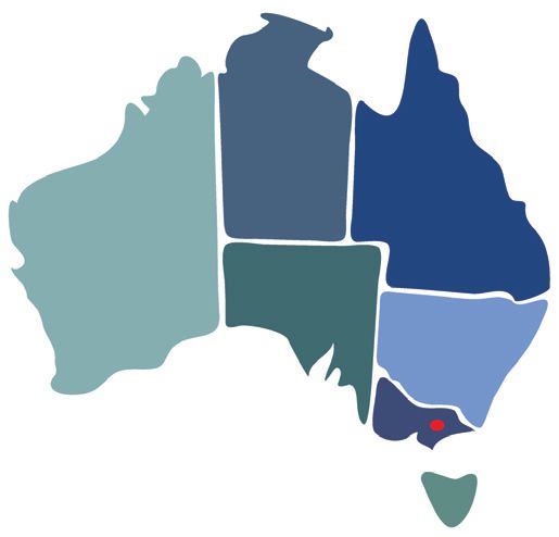
North East Victoria at a glance
The North East Victoria region
covers 1.96 million hectares, of
which 35% is under agricultural
production. Dairy, beef, lamb, wool,
cropping, horticulture and forest
products are among its major
industries. The region contributed
around $421 million to the
Australian economy in 2017–18.
Natural Low Level Dryland Irrigated Intensive Water
Environments Production Production Production Uses Bodies
A guide to weather and climate in North East Victoria
Primary producers make decisions using their knowledge and expectations of regional weather patterns.
The purpose of this guide is to provide insight into the region’s climate and an understanding of changes
that have occurred through recent periods. This information can potentially assist primary producers and
rural communities make better informed decisions for their business and livelihoods. This guide is part of
a series of guides produced for every Natural Resource Management area around Australia.
A climate guide for agriculture
North East, Victoria
Annual Rainfall
Annual rainfall in the North East has been relatively stable
Annual average rainfall in the North
East has been relatively stable,
falling by around 30 mm from about
1090 mm to about 1060 mm (-3%)
over the past 30 years (1989–2018)
when compared to the previous 30
years (1959–1988). The charts show
annual rainfall (blue bars), with a
10-year running average (solid blue
line) for Corryong and Wodonga.
Although the average annual rainfall
has been relatively stable, it still
fluctuates from year to year with
natural variability.
In the past 30 years (1989–2018),
dry years (lowest 30%) have oc-
curred 10 times and wet years
(highest 30%) have occurred nine
times, while the remaining years
were in the average range. Note
the Millennium drought accounted
for seven of these dry years in the
recent period. During the previous
30-year period (1959–1988), dry
years occurred nine times and wet
years occurred 11 times.
For more information on future projections, Want to know more about the guides?
visit the Climate Change in Australia website Try Frequently Asked Questions at
> www.climatechangeinaustralia.gov.au > www.bom.gov.au/climate/climate-guides/
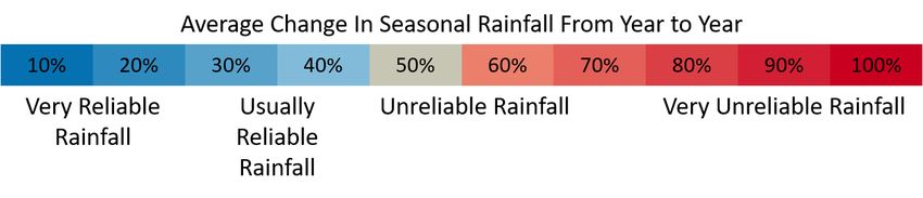
North East Victoria winter rainfall is reliable; summer is unreliable
Average rainfall reliability maps for the past 30 years (1989–2018) show winter rainfall has been moderately
reliable across the region (blue areas), usually changing by about 110 mm from one winter to the next. This
is in contrast to spring and autumn rainfall, which has been less reliable (light red and beige areas).
Summer rainfall has been mostly unreliable across the region’s north west (red areas). Although there have
been some wet summers in the past 30 years, some have been very dry. Overall, summer rainfall has not
been reliable from year to year.
Winter Spring Summer Autumn
2 A climate guide for agriculture North East, Victoria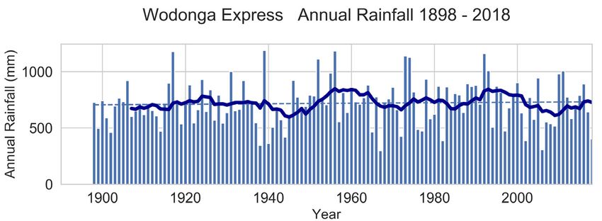
Rainfall Timing
There has been a decrease in rainfall in the autumn and spring months
Rainfall in the late autumn and
early spring months decreased at
Corryong and Wangaratta
between 1989–2018 (orange bars)
compared with 1959–1988 (blue
bars). In the summer months, as
well as in June, average
monthly rainfall totals increased.
Other locations around the North
East Victoria region showed a
similar pattern.
Over the past 30 years, winter
growing season rainfall (April to
October inclusive) for Wangaratta
was 370 mm; 66 mm lower than
the 426 mm average for the
previous 30-year period (1959–
1988). For Corryong, growing
season rainfall has declined 17
mm over the same period, from
530 mm to 513 mm to 370 mm.
For more information on the latest observations and science behind
these changes, refer to the State of the Climate Report
> www.bom.gov.au/state-of-the-climate/
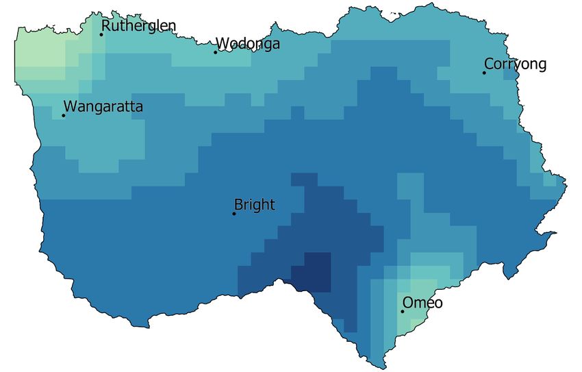
Timing of the autumn break in the North East region
In North East Victoria, the autumn break
can be defined as at least 25 mm over three
days prior to the commencement of sowing.
The map shows that over the past 30 years
(1989–2018), the break typically occurred
from mid-to-late April in the alpine regions
in the south of the region around Bright (blue
areas), mid-to-late May around Wangaratta
and Corryong (blue-green areas), and not
until June in the north, west of Rutherglen
(light green areas).
Across the northwest and around the
Victorian Alps in the southeast part of the
region in the last 30 years, the autumn break
is occurring up to a month later than it did in
the previous 30-year period (1959–1988).
A climate guide for agriculture North East, Victoria 3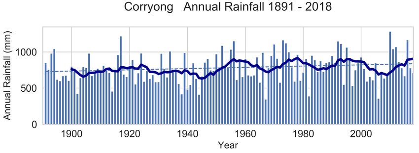
A climate guide for agriculture North East, Victoria
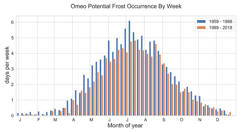
Frost
Later and more frequent frosts
The number of potential frosts has increased at Rutherglen and decreased at Omeo between 1989–2018 (or-
ange bars) compared with 1959–1988 (blue bars). Frost frequency increased in spring, with an average of six
more spring nights at Rutherglen with the potential for frost between 1989–2018 compared to 1959–1988.
Rutherglen’s frost risk usually ended within the second week of November, but can occasionally extend into
December. A potential frost night in December has happened twice in the last 30 years at Rutherglen. Omeo,
in the alpine region, has typically seen the last frost of the year by the end of November, but a night with a
potential for frost can happen at any time of the year.
In the northwest of the region, around Wangaratta and Rutherglen, more frosty nights have tended to occur
through dry winter and spring periods, when soil moisture is low and cloud cover infrequent. On average,
Wangaratta gets twice as many winter and spring frosts during and following a dry winter than a wet winter.
Rutherglen has had around seven more frost nights during spring following a dry winter than after a wet
winter. Other locations in the river valleys and open plains show a similar pattern, however higher elevation
locations, such as Omeo do not show a strong link between potential frost nights and winter rainfall.
Temperature
North East Victoria has experienced more hot days in the past 30 years
The chart shows the annual
number of days above 38 °C (red
bars), with a 10-year running
average (solid red line) for Ruth-
erglen. Rutherglen experienced
an average of seven days per year
above 38 °C between 1989–2018,
compared to an average of three
days per year above 38 °C between
1965–1988. Over the last 30 years,
temperatures above 44 °C have
been recorded for Rutherglen eight °C twice, both in 1939. Missing ob- In 2014 and 2019, Rutherglen expe-
times, including three times in servations during summer months rienced periods of seven or more
January 2019. Between 1965–1988 between 1957 and 1964 excluded days in a row above 38 °C. Each of
the temperature at Rutherglen these years from the counts of these runs also included five days
exceeded 44 °C only once, in 1968. hot days. Instances of consecutive in a row above 40 °C. The last time
Before 1956 the recorded tempera- days above 38 °C have also been runs of this magnitude were re-
ture at Rutherglen rose above 44 more frequent in the past 30 years. corded in Rutherglen was in 1939.
Regional Weather and Climate Guides are produced as a partnership between Bureau of Meteorology, CSIRO and FarmLink
© 2019 Bureau of Meteorology and the CSIRO. The information contained in this
publication cannot be reproduced without the written permission of Bureau of
Meteorology and the CSIRO. Requests and enquiries concerning reproduction and
rights should be addressed to the Bureau of Meteorology. DISCLAIMER: The infor-
mation contained in this publication is offered by the Bureau of Meteorology and
CSIRO solely to provide general information. While all due care has been taken in
compiling the information, the Bureau of Meteorology and CSIRO and its employ-
ees, accept no liability resulting from the interpretation or use of the information.
Information contained in this document is subject to change without notice.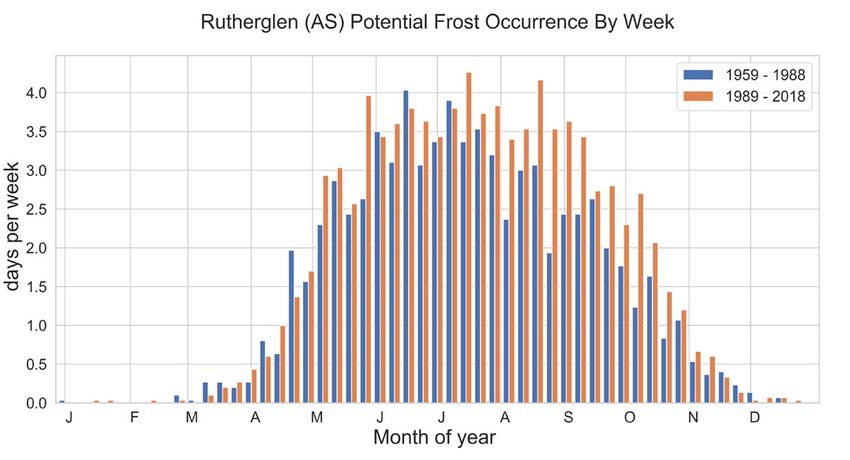

You can also read