The Winter of 2019/20 - Dawn from Met Éireann HQ, December 1st 2019 - A Marginal Night
←
→
Page content transcription
If your browser does not render page correctly, please read the page content below
The Winter
of 2019/20
Dawn from Met Éireann HQ, December 1st
2019 – A Marginal Night

A Milder and Wetter than Average Season
• Eighth (8th) mildest season in the
  22 year series
• Average Road Minimum
  Temperature of 3.8 °C
• 1.03 °C lower than last year, the
  2018/2019 season, which remains
  the mildest season in the 22-year
  series.
• 0.21 °C higher than the previous
  year, 2017/2018 which
  incorporated Storm Emma.
Largest number of stations to date
• The statistical analysis was
  performed across more than 100
  stations for the first time.
• Analysis was carried out on 101
  stations compared to 89 last
  year as the road monitoring
  network continues to expand.

The lowest road temperature of the season
was -6.4 °C.

                         - 6.4C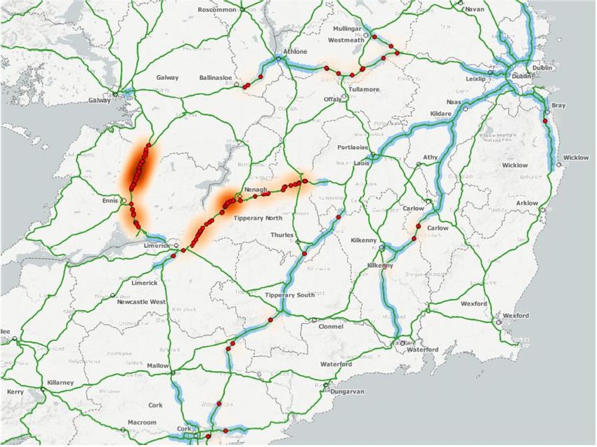
Coldest night for Road & Air temperature
• 19th January 2019
• Lowest Road Surface
  Temperature was -6.4 °C
  recorded at Milltown Pass in Co.
  Westmeath
• Lowest Air Temperature -6.9 °C
  was reported at Baltinglass Co.
  Wicklow

The Season of 2019/2020

 Aftermath of hail shower at Birdhill in County Tipperary which caused multi car
collisions on 11th December 2019 courtesy of James O’Dwyer via Stephen Smyth.
The Season of 2019/2020

 Snow lying at Knock Airport on Jan 27th 2020 courtesy of Ireland
                   West Airport Twitter Page
The Season of 2019/2020

Tree down near Fermoy during the passage of Storm Brendan on
                       Jan 13th 2020
The Season of 2019/2020

 April 2020 Daily Sunshine and Temperature values at Valentia
            Observatory, Dublin Airport & Belmullet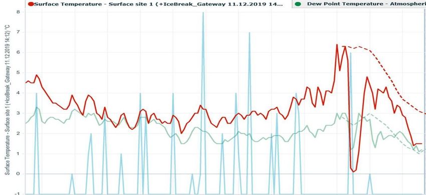
How did that translate to RSTs?
Instances of Frost
• The average percentage frost across the 101 stations examined for
  2019/2020 was 14.6%
• Emyvale, Co. Monaghan returned the highest % of night frosts at 31.2% or
  63 frost nights over the season.
• Emyvale was followed by Baltinglass, Co. Wicklow (26.9%) and Funshog,
  Co. Louth (26.1%)
• Comparing to last year 2018/2019: Lough Mourne, Co. Donegal had the
  highest % of frost nights last year with 20.24%. This year Lough Mourne
  recorded 22.1% of frost nights.
Instances of Frost … Continued
• The mildest station was Waterville, Co Kerry which reported just 2.4%
  of night frosts during the entire season equating to 5 nights.
• Dublin Port Tunnel, Limerick Tunnel, Bunratty, Co. Clare, Dublin
  Airport M50 and Dublin Airport M1 all reported less than 5% of night
  frosts (they all had either 9 or 10 frost nights over the entire season).
• Waterville, Limerick Tunnel and Bunratty were among the mildest
  stations last year also.
Graph of % frosts
Frequency of Night Frosts in different temperature ranges over
                       the last 5 years
Monthly Breakdown of frosts across the Network
Comparing that to last couple of years….
Marginal Nights –
when RSTs of less than
2°C were observed.
• 2019/2020 had the highest
  number of marginal nights in the
  last 5 years.
• 3051 nights or 19% of nights
  were in the 0 to +2 degrees
  Celsius range
• Compared with 12.8% in
  2018/2019 , the mildest season
  in the series, and 16.7% in
  2017/2018, the coldest season in
  the last 5 years.
Statistical Analysis
of 2019/2020
Season
• The analysis was performed
  between October 1st 2019        Brace Yourselves,
  and April 30th 2020
• A total of 212 days across      Statistics are
  101 sites
• 20,746 observational days
                                  Coming….
• The season returned 3,026
  site frosts – resulting in an
  average of 30 frost days per
  station across the network.
The Statistical Analysis was executed only on
“Critical Site Days”
• Critical Site Days refer to days
when the RST < 5 °C
• There were 13,211 Critical Days
or 63.2% of valid days during the
period
• On 3,951 or 19% of all valid
nights, the minimum RST lay
between 0 and 2 °C – marginal
nightsForecast versus Persistence
Statistically how did the forecast perform?
Bias
• The average bias across the 101
  stations was 1.19 (optimal value is 1)
• 53 stations had a bias >1 (over
  forecasting of frost)
• 41 stations had a bias
Summary of statistical results
• Percentage Correct = 87.7%
• Mean Square error (MSE) = 76%
• False Alarm Rate (FAR) = 8.6%
• Probability of Detection (POD) = 77%
• Critical Success Indicator (CSI) = 57.8%
• True Skill Statistic = 68.6%
• Mean Error = 0.01
Factors not captured in the Statistical Analysis
• No evaluation of tabular hazard matrix and text
• No assessment of the consultancy service
• No validation was made of the thermal maps

(On marginal nights , the thermal maps will generally produce lower
temperatures (often below zero) over a contiguous sections of road)
Case from last December…
And Gweedore…..
Hazard Matrix
A quick look at Hail Events
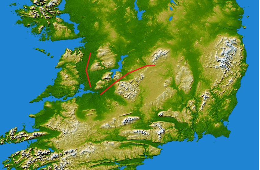
Where & When do we get hail?
• Most common in western parts of Ireland where it occurs most
  frequently in winter and early spring.
• The land is cold compared to the sea at this time of year so showers
  form over the North Atlantic driven by the heat energy of the sea.
• Once the showers reach the cold land they tend to lose their driving
  force (the relatively warmer sea) so there will tend to die out before
  they get too far inland.
Where do we get hail?
• However, sometimes if
  the atmospheric
  conditions are right
  higher up in the air, the
  showers can continue
  even over the cold land
  and may affect central
  and eastern parts of
  Ireland too.
• Showers (not just hail
  showers!) will often form
  over hills where moving
  air is forced to rise over
  them
Zooming in on this area
Relief Map
What does a hail shower look like in a graph?
Other examples
How does it look for this Winter?
• La Nina is established in the tropical Pacific. Models agree that La
  Nina conditions will continue well into the winter, with some
  predicting a strong event.
• Correlations between Euro-Atlantic climate and ENSO yield only weak
  and inconclusive results – but the evidence suggests a positive NAO is
  favoured.
Monthly Forecast from ECMWF
• Drier conditions over the coming week, especially in the west.
• Colder than average by between 1 to 2 degrees in a predominantly
  northerly airflow.
• Week 2 suggests low pressure to the south of Ireland steering a more
  southerly airflow in, so temperatures likely returning to normal.
• No strong signal for week 3
• Wetter than average in the north and west during week 4 (start of
  Nov) with average temperatures
Thank you for
your attention.
You can also read


