Review of Macro Strategic Plan of DP 2011 and Proposed DP 2025 for Bhuj Area, Kutch: A Study
←
→
Page content transcription
If your browser does not render page correctly, please read the page content below
GRD Journals | Global Research and Development Journal for Engineering | Emerging Research and Innovations in Civil Engineering
                                                                                                   (ERICE - 2019) | February 2019
                                                                                                                e-ISSN: 2455-5703

   Review of Macro Strategic Plan of DP 2011 and
  Proposed DP 2025 for Bhuj Area, Kutch: A Study
               1Prashitha.    C 2Gayathri. M. P 3Bhagyashree Sisode 4Dr. Krupesh A. Chauhan
                                1,2
                                    M.Tech Student 3Ph.D. Scholar 4Associate Professor
                                         1,2,3,4
                                                 Department of Civil Engineering
                                            1,2,3,4
                                                    SVNIT, Surat, Gujarat, India

                                                            Abstract
The development plan is a macro strategic plan document that defines the direction of growth and envisions the city wide
infrastructure for the entire development area. It is a comprehended document that looks at all the components of development and
makes specific proposals with respect to each. Bhuj city is the administrative headquarter of Kutch District, Gujarat. BHADA has
taken up effective steps in the journey of development to achieve the well-determined vision to provide infrastructure facilities,
new town planning of the earthquake affected city of Bhuj, rehabilitation of the earthquake affected people of the city at newly
developed relocation sites and to make Bhuj a well-planned city. This paper is based on the study of the existing scenario and road
infrastructure of BHADA. The study concludes with the comparison of the revised DP of 2011 and the proposed DP 2025.
Keyword- Macro Strategic Plan, Rehabilitation, Development Plan, Infrastructure
__________________________________________________________________________________________________

                                                      I. INTRODUCTION
Gujarat has a fairly good and robust legislative framework for urban planning as compared to other states in India. This is, the
Gujarat Town Planning and Urban Development Act (GTPUDA), enacted in 1976 by the parliament. The GTPUDA mandates the
delineation of a “Development Area” around a city or a town for planning purposes. Bhuj Area Development Authority, which is
well-known by its short name ‘BHADA’, was established after the disastrous earthquake of 26th January 2001, under section 22
of Gujarat Town Planning and Urban Development Act 1976 on 9th May 2001 for rehabilitation and reconstruction of the city.
During the short span of its establishment, BHADA has taken up effective steps in the journey of development to achieve the well-
determined vision to provide infrastructure facilities, new town planning of the earthquake affected city of Bhuj, rehabilitation of
the earthquake affected people of the city at newly developed relocation sites and to make Bhuj a well-planned city. Its jurisdiction
covers the total area of 5642.67 hectares comprising of Bhuj City and also includes nearby areas of Mirzapar & Madhapar villages.

                                                   II. NEED OF THE STUDY
To undertake the preparation of development plans under the provisions of Section 23 of the Gujarat Town Planning & Urban
Development Act, for the urban development area. To carry out surveys in the urban development area for the preparation of
development plans and town planning schemes. To execute works in connection with supply of water, disposal of sewerage and
provision of other services and amenities. To control the development activities in accordance with the development plan in the
urban development area.

                                                        III. STUDY AREA
Bhuj is a Muncipality and District Headquarter of Kutch District in the state of Gujarat. Bhuj has a total area of 56sq.km and an
average elevation of 110 meters (360ft). On the Eastern side of the city is a hill known as Bhujia Hill that separates Bhuj city and
Madhapar town. It has two lakes namely Hamirsar and Dehdasar.

                                                                             All rights reserved by www.grdjournals.com           113
Review of Macro Strategic Plan of DP 2011 and Proposed DP 2025 for Bhuj Area, Kutch: A Study
(GRDJE / CONFERENCE / ERICE - 2019 / 024)
Fig. 1: Study area: Bhuj
IV. OBJECTIVES OF THE STUDY
– To review the changes in development plan of 2011 and 2025.
V. EXISTING SCENARIO
As per Census 2011, BHADA area has witnessed an increase in population in the last decade from 170221 to 188236 at a growth
rate of 10.58% which is significantly lower than India (21.54%) and Gujarat (22.796). This is attributed due to the Earth-quake of
2001. The total population in the BHADA area is expected to go up to 247621 by 2021 and 277336 by the year 2025.
A. Land use Zoning
The sanctioned Development plan covered an area of 56.23 Sq.km of which 10.4 Sq.km of area is covered under agriculture
whereas 27.56 Sq.km is covered under residential. Total vacant agricultural area is 38.58%. Table 1 shows the land use distribution
of Bhuj area.
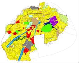
Fig. 2: Revised Development Plan 2011 Fig. 3: Proposed Development Plan 2025
Sr.No Use of land Proposed Land use(sq.m) % Land use
1 Residential 2756.9 49.2
2 Gamtal 152.19 2.7
3 Commercial 244.48 4.4
4 public/Institutional 253.6 4.5
5 Industrial 262.77 4.7
6 Graveyard 14.551 0.3
7 Recreational 374.19 6.7
8 Defense area 216.97 3.9
9 Water Bodies 177.74 3.2
All rights reserved by www.grdjournals.com 114Review of Macro Strategic Plan of DP 2011 and Proposed DP 2025 for Bhuj Area, Kutch: A Study
(GRDJE / CONFERENCE / ERICE - 2019 / 024)
10 Agriculture 580.02 10.4
11 Road and Transport 507.27 9.1
12 Forest land 48.23 0.9
13 Reservation 11.6 0.2
Total 100.0
Table 1: Land use Distribution
(Source: Revised Bhuj Development plan 2011)
The Above table denotes the land use zoning distributed as per Bhuj Development plan 2025. Fig 2 shows land use
distribution as per DP 2011 and fig 3 shows proposed DP 2025 The maximum percentage of land is covered under the Residential
Zone which is 2756.9sq.km. It consumes 49.2% of the total land distributed.
B. Housing
A set of proposals and recommendations have been identified to cater to the housing needs and make provisions for housing units
that can be afforded by the EWS, LIG and MIG segments.
Sr.No Housing Need and Demand Number
1 Present Households 42597
2 Present Population 188236
3 Present Housing Need 47059
4 present Housing Gap 4462
5 Population Projection for year 2025 277336
6 Future Housing Demand 69334
Table 2: Housing need and demand
(Source: Proposed Bhuj Development plan 2025)
C. Source of Water
Bhuj has 74.7 % household, which have access to open drainage and 21.3 % household don’t have access to any drainage. Hence,
the major Chunk of water generated by 78.7 % household in city would reach for disposal in Khari River. There is no treatment
facility except decentralized wastewater system which has capacity of 0.03 MLD and 0.095 MLD respectively.
D. Social Infrastructure
Educational institutions: Bhuj has eleven Pre Primary schools, thirty Higher Secondary schools, four Colleges and a University.
Bhuj has several institutions that provide special education including Music schools, Private Classes. Training institutes etc.
E. Health
Bhuj has few multi-specialty hospitals. Apart from public hospitals, private hospitals and clinics for specialized treatments, modern
pathological centers and alternative modes of treatment are also there in Bhuj to serve its people as well as those who come here
from outside.
F. Fire and Emergency Services
Fire and emergency services are a municipal function in Gujarat. Fire services in Bhuj have well-trained fire fighters along with
all types of modern equipment to handle sudden fire and reduce the loss of life and property especially when fire is caught in multi-
storied buildings.
G. Road Network Scenario
The Bhuj City follows radial pattern of road network at macro-level in the Development plan grid-iron pattern of road network
inTown planning schemes. Street network before the 2001 Earthquake was not following any regular pattern, but the
implementation of first development plan-2001 and later of 2011 and existing 2025 lead to follow the roads in systematic way. No
road in the walled city was more than 6 feet before T.P. Schemes, but the implementation of T.P. Schemes introduced all roads
more than 36 feet width which helped to cater busy city centre traffic.
The three ring roads - Inner, middle and outer ring roads are the major transportation corridors of the city. Gaurav path of
Bhuj lengths 90m from Managalam Garden to Khengarji Park and is the well street furnished road of Bhuj city.
VI. LANDUSE CHANGES IN REVISED DP 2011 AND PROPOSED DP 2025
– In the development plan 2025, new land for the residential purpose has been reserved around the outermost ring road (Airport
Ring Road) in the North West Zone of the city.
– In DP 2011, the area reserved for agriculture was around 249180 m², from which around 245720 m² of land is converted to
residential purpose which is 98.6% remaining land of around 3460 m².is reserved for agriculture.
– There were many plots reserved on the other side of the Hamirsar lake in 2025 DP and hence the land reserved for public
purpose were shifted to the airport ring road area. The area of new residential land is around 5120m².
– In DP 2011 area reserved for public purpose in the North West zone of city, is converted to residential zone in DP 2025.
All rights reserved by www.grdjournals.com 115Review of Macro Strategic Plan of DP 2011 and Proposed DP 2025 for Bhuj Area, Kutch: A Study
(GRDJE / CONFERENCE / ERICE - 2019 / 024)
– Some land in the North East Zone of the city was reserved for agriculture purpose in 2011 DP but converted into residential
area to support the population increase and housing demand in 2025 DP.
– Some of the plots reserved for residential zone is converted into public place in DP2025.
– the proposed location for stadium in the and sports complex in DP 2011 in north east zone is converted into residential area in
DP 2025 to support the population growth and housing demand of future.
– Industrial area in north east zone proposed in DP 2011 is reduced in DP 2025.
– An area of around 20680 m², which was reserved for residential purpose in DP 2011, is converted to commercial purpose in
DP 2025.
Fig. 4: Inventory Data Collection from BHADA
VII. IDENTIFICATION OF ISSUES
– Jubilee circle is the most traffic congested junction.
– Waste water is being dumped in outskirts of city.
– The excavated earth material of the development and the demolished trash of building and pavements are simply thrown along
both sides of the outer ring road.
– Even after the implementation of TPS in the core city, the road pattern does not follow regular grid-iron system.
– The whole city is not getting continuous supply of water.
– Due to non-availability of storm water drainage, during monsoon, the middle ring road is under water when excessive rains
and thus leads to shutting of traffic movement in those days.
VIII. FINDINGS
– Provide street furniture, signalling of junction and traffic cops at Jubilee circle.
– Waste water treatment and disposal strategic plan need to be worked out.
– A strategic plan for city level efficient water network should be prepared.
– Since 44% of water supply source is ground water so recharge wells to be constructed at different locations in city to conserve
groundwater
– Provide storm water drainage near the middle ring road.
IX. CONCLUSION
The existing scenario of Bhuj Area Development Authority was studied and the changes in development plan of 2011 and 2025was
analyzed. The revision work includes the various planning task like updation of Cadastral Map, Existing land use survey, Total
station and DGPS survey, Stakeholder consultation, etc. The main purpose of DP 2025 is to decentralize the Services. The existing
road infrastructure under BHADA was studied. The city has about 250 km of road network. With respect to road condition 656 of
the roads are surfaced and 3576 are roads with earthen surfaces. There were inner ring road, middle ring road and outer ring road.
ACKNOWLEDGEMENT
This study is prepared out of the academic exercise carried out by the group of students for the study of the development plan of
Bhuj Area Development Authority. The exercise was done by students undertaking master’s degree in urban planning at SVNIT
All rights reserved by www.grdjournals.com 116Review of Macro Strategic Plan of DP 2011 and Proposed DP 2025 for Bhuj Area, Kutch: A Study
(GRDJE / CONFERENCE / ERICE - 2019 / 024)
Surat. We are thankful to Officer in charge BHADA, Office staff of BHADA and Sree.Kiritbhai Sonpure, Ex. Chairman of
BHADA who has helped us in guiding the procedure and giving access to the required data.
REFERENCES
[1] Bhuj Area Development Authority: Revised Draft Development Plan, 2011 AD; Part I, Vol. I and II
[2] Government of Gujarat (1976): Gujarat Town Planning and Urban Development Act, 1976.
[3] Government of Gujarat, Gujarat Town Planning and Urban Development Act, 1976 and Rules, 1979.
[4] Institute of Town Planners (1996): Urban Development Plans Formulation and Implementation.
All rights reserved by www.grdjournals.com 117You can also read